EVALUATION OF THE ADAPTABILITY AND RESPONSE OF POTENTIAL INDEGENOUS TREES TO WATER HARVESTING
IN THE REHABILITATION OF KURIFTU LAKE CATCHMENT
BY
WONDWOSSEN GEBRETSADIK
July, 2009
MSc Thesis Mountain Forestry
UNIVERSITY OF NATURAL RESOURCES AND APPLIED LIFE SCIENCES (BOKU), VIENNA, AUSTRIA
EVALUATION OF THE ADAPTABILITY AND RESPONSE OF POTENTIAL INDEGENOUS TREES TO WATER HARVESTING
IN THE REHABILITATION OF KURIFTU LAKE CATCHMENT
BY
WONDWOSSEN GEBRETSADIK
SUBMITTED TO: UNIVERSITY OF NATURAL RESOURCES AND APPLIED LIFE SCIENCES, VIENNA
IN PARTIAL FULFILLMENT OF THE REQUIRMENTS FOR THE DEGREE OF MASTER OF SCIENCE IN MOUNTAIN FORESTRY
UNIVERSITY OF NATURAL RESOURCES AND APPLIED LIFE SCIENCES, VIENNA, AUSTRIA
DECLARATION
I, Wondwossn G/Tsadik, hereby declare that this thesis is part of my own work and it has not been submitted to any other universities or colleges before.
__________________________ _________________
Wondwossen G/Tsadik Date
I, main advisor of the student confirm that this thesis has been examined and got my approval.
_______________________________
Glatzel, Gerhard O.Univ.Prof.Dipl.-Ing.
Dr.nat.techn.
P.O Box E-mail:
I
Abstract
Accelerated soil erosion and land degradation is peculiar to hill side lake catchments that are devoid of vegetation cover. When trees and shrubs on hill sides are removed the soil on the site will be exposed and it will easily be eroded by various agents of erosion since it loses its aggregation and stability. Subsequently up slopes will lose their productive potentiality and transported top soils to down slope cause problems of displacement and drying of lakes through time. With the prevalence of such phenomena hill sides will ultimately doom to irreversible conditions of site degradation. The study aimed at evaluating the potential of adaptability and performance of five tree species to rehabilitate the degraded hill side of Kuriftu Lake catchment and the role of artificial water harvesting structures, such as infiltration pits, in the process. The study shows that different tree species have significantly varying potentials to adapt and rehabilitate such degraded hill sides. In addition water harvesting structures significantly augment seedling establishment of some tree species on hill sides while other species could establish without them.
According to this study a significant decline in the height growth of Acacia abyssinica in steeper slope classes was redeemed by infiltration pits. Tree species like Dodonaea angustifolia showed no need for water harvesting structures especially in gentler slope classes. Comparable mean height growth indicates comparative hardiness. It was also found that planting of tree species like Acacia seyal to rehabilitate such hill sides should be restricted to gentler slopes and augmented by infiltration pits. Height growth of this species showed a significant decline on steep slopes that could not be redeemed through the use of pits. Olea africana performed better on gentle slopes with water harvesting pits. The results indicate that comparable performances of this species could be attained in steeper slope classes when seedlings are planted with infiltration pits. Euclea schimperi has been found to perform poorest among the species evaluated in this rehabilitation study.
Key words: Hardiness, infiltration pits, Kuriftu Lake catchment, land degradation, water harvesting.
II
Acknowledgement
Most of all, my profound thanks go to the Almighty God for His mercy, care and protection throughout the course of my study and fieldwork.
I would like to express my deepest appreciation to the North South Dialogue scholarship program for offering me the opportunity of scholarship to join Mountain Forestry Masters Program at the University of BOKU and explore about the international study atmosphere.
I would like to extend my heartfelt thanks and appreciation to my academic advisor Prof. Dr. Gerhard Glatzel for giving me permission and advice to base my field work and thesis on an ongoing research project that I initiated three years ago.
I would also like to express my profound appreciation to the dedicated secretary Miss Melanie Gertheienrich at the Institute for assisting me in final wording and formatting of my thesis.
I am very grateful for the staff of Forestry Research Division at Debre Zeit Agricultural Research Center for their unreserved and dedicated participation and support especially in the construction and maintenance of earthwork structures in the study area and their assistance in carful data collection activities.
I would like to acknowledge the collaboration of the Orthodox Church community at the hilltop of the study area towards the realization and success of the project.
Finally, I really thank my wife Ejgayhu Gashaw for the unreserved motivation she has always given me all the way through my undertakings and for her care, affection and patience with our kids in all the time that we have been separated.
III
Table of content Page
Declaration I
Abstract II
Acknowledgement III
Table of content IV
List of figures V
List of tables VI
Abbreviations VII
1. Introduction 1
1.1. General background 1
1.2 .Objectives 2
2. Literature Review 3
2.1. Intimacy and impact of man on forests 3
2.2. Soil loss on hillsides 4
2.2.1. Agents of soil erosion on hill sides 5
2.3. Topographic description of Ethiopia 6
2.3.1. Soil loss and land degradation in Ethiopia 7
2.3.2. Consequences of deforestation 8
2.4. Fundamental Ideas about soil 9
2.4.1. The need for Soil and water conservation 11
2.4.2. Water harvesting general overview 12
2.4.3. Contour bunds for trees 14
3. Materials and method 15
3.1. Description of the study area 15
3.2. Description of trees for evaluation 17
3.3. Experimental design and field layout 21
3.4. Data collection and analysis 28
4. Result 28
4.1. Height growth 23
4.2. Stem diameter 35
4.3. Survival of planted trees 39
5. Conclusion and recommendation 42
5.1. Conclusion 42
5.2. Recommendations 43
6. References 45
7. Appendices 49
IV
List of figures Page
Figure 1: Major types of water harvesting structures 13
Figure 2: Location of the study area 16
Figure 3: Acacia abyssinica in the field 18
Figure 4: Euclea schimperi in the field 18
Figure 5: Olea africana in the field 19
Figure 7: Acacia seyal in the field 20
Figure 8: Alignment of contour bunds, cross ties and infiltration pits 22 Figure 9: Alignment of bunds, infiltration pits and Cross ties in the field 23
Figure 10: Planting position for seedlings 24
Figure 11: Illustrations of planting positions in the experimental area 25
Figure 12: Field layout and randomization 26
Figure 13: Assignment of treatments within a block in the field 27 Figure 14: Mean height distribution of evaluated tree species 31
Figure 15: Acacia abyssinica with pits in slope class II 32
Figure 16: Acacia abyssinica with pits in slope class I 32
Figure 17: Dodonaea angustifolia with pit in slope class I 32 Figure 18: Dodonaea angustifolia without pit in slope class II 32 Figure 19: Height growth differences of species after three years 33
Figure 20: Acacia seyal with pit in slope class I 34
Figure 21: Olea africana with pits in the study area 35
Figure22: Performance of Euclea schimperi in the field 35
Figure 23: Mean diameter distribution of evaluated tree species 38 Figure 24: Mean survival distribution of evaluated tree species 41
V
List of tables Page
Table 1: Analysis of variance table for height 29
Table 2: Multiple mean height comparison of tree species evaluated 30
Table 3: Analysis of variance table for diameter 36
Table 4: Multiple mean diameter comparison of tree species evaluated 37
Table 5: Analysis of variance table for survival 39
Table 6: Multiple mean survival comparison of tree species evaluated 40
VI
Abbreviations
AEZ- Agro Ecological Zone ANOVA- Analysis of Variance A.S.L- Above Sea Level
B.S.L- Below sea Level
DMRT- Duncan’s Multiple Range Test
DZARC - Debre- Zeit Agricultural Research Center FAO- Food and Agricultural Organization
MOA- Ministry of Agriculture
NRSC- Natural Resource Conservation Service OTA- Office of Technology Assessment
UNEP- United Nations Environment Program WWF- World Wildlife Fund
VII
1. Introduction
1.1. General background
Many hillsides in the Ethiopian highlands have been excessively degraded to address smallholder farmers’ demands of mainly firewood and food. These hillsides are commonly owned and their management and rehabilitation has been very complicated.
A study conducted in Northern Wello, Ethiopia however demonstrated that with sufficient seed source from the surrounding remnant vegetation in the soil seed bank natural regeneration is a potential solution to rehabilitate degraded hillsides.
Otherwise, if regeneration under natural condition cannot be effected, rehabilitation of such hillsides is carried out by planting using potential tree species that can withstand the prevailing condition of the site.
Among the major lakes of potential scenic value found in the Ada Liben woreda East Shoa zone, Oromia is Lake Kuriftu with an estimated total area of 4 hectare and with an elevation of 1883m a.s.l. It is located at 8046’28”N and 39000’38”E.
The total annual rainfall in the area where the lake is located for the year 2002 is 745.6 mm (station record), which would be adequate for normal tree growth and establishment.
Apart from some minor uses for recreation and water supply, the potentials of the lake are not fully utilized in an environmentally friendly approach. Presently it is very difficult to find naturally growing trees on the hillsides of the lake due to severe soil degradation process that resulted from encroachment and cultivation of the site for years.
As to the role of role of repeated cultivation in reducing regeneration potential of a site Demel (1996) states that if the soil is disturbed and brought under continuous cultivation, these activities effectively prevent the recovery of woody vegetation and create favorable condition for the accumulation of herbaceous species which will later on be replaced by weeds. Although it has been pointed out that the annual rainfall in the study area is sufficient to maintain tree growth, according to FAO (1987) on top of sufficient rainfall, soil moisture and depth ought to be maintained to grow trees in the tropics to make up for the shallow soil depth and poor moisture storage.
1
The soil in the study area is mainly Andosol, which according to Mesfin (1998) is characterized as fine textured and among the most productive soils of Ethiopia given adequate supply of water. In spite of this, Driessen & Dual (1991) strongly indicated that even though Andosols are relatively productive and resistant to water erosion due to their permeability, up on deforestation and air drying they are highly liable to wind and water erosion. There should be a mechanism to assist water infiltration and moisture status for these soils and thereby contribute to tree growth and establishment especially on degraded hill sides like the study area. This calls for the use of water harvesting techniques along different slope classes of the study area to assess the adaptability of potential tree species.
According to FAO (1991) water harvesting is the collection of run off for productive purposes instead of it being left to cause erosion. In semi arid and drought prone areas it is a directly productive form of soil and water conservation.
Apart from the impact of continuous cultivation that reduces the regeneration potential of trees by abandoning seeds of climax species, the study area experiences the negative impact of the relation that exists between slope and soil depth. Slope is the angle formed by the surface of the soil with the horizontal.
According to (Toumey, 1974), slope controls runoff and drainage and hence this will have effect on the water content of the soil. Soil depth and moisture status vary almost directly with the gradient when other conditions are held similar.
These makes the classification of the study area in to different slope classes and study the role of water harvesting structures to moisture retaining and early seedling establishment important.
Adequate information on the type of tree species adaptable to the hillside particularly with respect to moisture stress and poor soil depth is not available.
Knowledge of integrating water harvesting with tree planting on hillsides is not well full-fledged though not new to the area. Therefore the existing hillside soil erosion and land degradation problems call for the research task of identifying adaptable potential tree species through water harvesting under the prevailing conditions of the study area.
1.2. Objectives:-
: Evaluate the adaptability potential of indigenous tree species for the rehabilitation of the degraded hillside.
: Evaluate the role of water harvesting structures for adaptability of seedlings on degraded hillsides.
2
2. Literature Review
2.1. Intimacy and Impact of Man on Forests
Humans have a long time history of dependency on forest and forest products.
Forests provide timber as well as non timber forest products that have direct utility in the day to day lives of people. In addition forests provide indirect use of preventing soil erosion by runoff through their canopies (excepting canopy drips) and root system and they are also involved in modifying the microclimate of an area. Generally speaking forests are sources of basic necessities of life, natural homes for biodiversity, collectors and storerooms of water, ecosystems of complex food webs of life and shelters for diverse forms of life on earth.
Forests offered the first bipedal ancestors of Homo sapiens on wooded grasslands of East Africa with food in the form of plants and animals, and water. After the discovery of fire, wood was used for burning, and later on for making tools. As life evolved, humans started clearing land for agriculture and opted for more and more settled way of life (WWF, 2006).
The major change in human history that affected the environment was the beginning of domesticated plants and animals. These events, independent in various places in the world resulted in agriculture, an increase in predictable food supplies and a rise in the human population. With the advent of agriculture humans transformed ecosystems and dominated them to the extent that they created new ones by substituting domesticated plants and animals in the areas once occupied by wild organisms. A consequence of agriculture was the domination of ecosystems by humans. Domestication provided a dependable and predictable food supply unlike what hunters and gatherers faced most of the time.
Dependence upon domesticated plants led to land clearance to increase the area dedicated to food production.
This advance in human history marked the beginning of deforestation which is the primary visible impact imposed by man on forests. This brought with it the start of one of one of the major processes of deforestation: forest clearing for food production. Patterns of shifting cultivation were developed that depended on the reinvasion of the forest to restore the fertility of the land (Kimmins, 1987).
Shifting cultivation has little effect on the forest provided that the fallow periods are long enough and size of population is small. However with increasing population and more demand for agricultural products, more land will be cleared 3
and the fallow periods get shorter. Extensive deforestation brings with it loss of soil fertility, higher surface runoff and soil erosion, increase in water pollution and flooding, increase in green house effect and loss of plant and animal species (http://library.thinkquest.org/26993/consequences.htm).
These days the ecosystem that gave us life is under severe threat. Early humans were hunter - gatherers, and later farmers, and because the population was small, the impact on the environment was minimal. But in the past couple of thousand years, the growing demands of an ever - increasing human population has halved the Earth's original forest cover. Forests are the Earth's largest and most productive ecosystem, and trees their most visible and important constituent.
Humankind's past is linked to the forest, and it is easy to see how its survival will map our future as well (WWF, 2006).
2.2. Soil Loss on Hillsides
Unwise utilization of soils results in the total loss in the productive potentiality of soil. Soils on hillsides that are devoid of vegetation cover are subject to accelerated soil erosion since the intensity of runoff increases with gradient. Erosion is the physical wearing away of the earth’s surface by the agents of wind, ice, water, or movement in response to gravity. Surface soil material is removed in the process.
The severity of erosion depends on a combination of many factors, including the amount and intensity of precipitation, the texture of the soil, the steepness of the slope, and the amount of ground cover. Erosion is often quantified in terms of tons of soil loss per acre per year. A ton of soil may be visualized as the thickness of a sheet of paper spread over an acre (Hillel, 1998).
There are two basic types of erosion namely Natural (also called geological) Erosion and Accelerated Erosion.Natural erosion occurs when soil is in its natural environment, surrounded by its natural vegetation. This type of erosion has been taking place over millions ofyears. While existing soil is gradually lost, new soils can be formed through the slow weathering of parent rock material, and from soil particles moved in by air and water. Under normal climate conditions, and with stable ground cover, soil losses from this type of soil erosion often can balance out, or even be less than the rate of soil production. On the other hand accelerated erosion is caused by the activities of human beings. By removing surface vegetation and plant residue cover, the soil becomes more vulnerable to removal by wind or water. Agricultural production can contribute to accelerated erosion, as can forest harvesting, surface mining, housing and construction, and urban highway construction, all of which eliminate stable plant cover (Zachar, 1982).
4
Whenever vegetation is removed, as when forests are cleared for agriculture, and the ground is exposed to rainfall, soil erosion by water and wind may increase. On sloping land it far exceeds the rate under natural conditions. Accelerated erosion, widespread throughout the tropics, is one of the most serious environmental and socioeconomic problems affecting rural people (Chamberlain, 1990).
The most prominent cause of soil loss on hillsides is water erosion. Raindrops can contribute to soil erosion when they strike bare soil. With an impact of up to 30 miles per hour, rain can blast apart good soil structural units and splash the soil into the air. If the ground is on a slope, the flying soil is easily picked up by water flowing overland and can be carried far away. Water erosion could take the form of sheet erosion, rill erosion and gulley erosion. Sheet erosion is the primary removal of the soil in thin layers from a sloping land, while rill erosion and gulley erosion are subsequent forms that cause removal of soil with water from land with poor surface drainage and advanced removal of soil with heavy loads of water out of fields respectively (wild,1993). Though soil erosion is a phenomenon that can never be stopped there are various measures that could be applied to minimize its consequences.
2.2.1 Agents of Forest Decline and Soil Erosion on Hillsides
The loss of protective vegetation through deforestation, over-grazing, plowing, and fire makes soil vulnerable to being swept away by wind and water. In addition, over-cultivation and compaction cause the soil to lose its structure and cohesion and it becomes more easily eroded. Erosion will remove the topsoil first. Once this nutrient-rich layer of soil is gone, few plants will grow in the soil again. The presence of vegetation prevents or reduces the likelihood of soil erosion. Plant roots form a network in the O- and A-horizons that bind soil particles together.
Where vegetation is sparse or absent, such as in arid or cleared areas, this binding agent is absent. Wind or running water easily erodes soils under these conditions.
Additionally, the canopy of leaves provided by vegetation lessens the erosive force of rain impacting on soil. Plants also reduce wind velocity near the ground surface, thereby lessening the ability of winds to erode and transport soil particles.
Wind and water are the main agents of soil erosion. The amount of soil they can carry away is influenced by two related factors; speed - the faster either moves, the more soil it can erode away, and plant cover - plants protect the soil and in their absence wind and water can do much more damage. The occurrence and rates of soil erosion depend primarily on amount and type of vegetation, slope, amount of rainfall, soil type, and any human activities (White, 2000).
The likelihood of soil erosion is directly related to the slope of the land. In flat or gently sloping areas, water infiltrates into pore space in the soil before beginning to run off at the surface. For short duration rainfall events, there may be little or no runoff, and therefore little or no soil erosion. In addition, the velocity of surface water movement is slower on gentle slopes, so that running water has less ability to erode and transport soil particles.
On the other hand White (2000) relates that on steeper slopes water begins to run off at the surface before all of the pore spaces are full. Running water also has a greater velocity on steeper slopes and therefore a greater ability to remove and transport particles. Both slope gradient and length will have an effect on the amount of erosion. Naturally, the steeper the slope of a field, the greater the amount of soil loss will be from erosion by water. Soil erosion by water also increases as the slope length increases due to the greater accumulation of runoff.
Consolidation of small fields into larger ones often results in longer slope lengths with increased erosion potential, due to increased velocity of water which permits a greater degree of scouring.
2.3. Topographic Description of Ethiopia
Ethiopia has extremely varied topography. The complex geological history that began long ago and continues, accentuates the unevenness of the surface; a highland complex of mountains and bisected plateau characterizes the landscape.
According to some estimates about 50 percent of African mountains, about 371,432 square kilometers above 2,000 meters, are in Ethiopia. Altitudes range from 126 meters b.s.l in the Dalol (Afar) Depression on the northern border, to the highest mountain, Ras Dejen in the Semen Mountains north of Lake Tana rising to 4,620 meters. The plateau in the northern half of the country is bisected by the East African Rift Valley, which runs more than 600 kilometers north–northeast of the Kenyan border to the Koka Dam on the Awash River south of Addis Ababa. The rift then descends to the northeast and its lateral escarpments begin to diverge from each other crossing the Afar depression toward the Red Sea coast (Mengistu, 2003).
Although the whole of Ethiopia lies within the tropical altitudes, the climate is cool in the highlands and warm in the lowlands. The annual range of temperature is relatively small because of the proximity of the equator. Rainfall variability generally increases as rainfall total decreases, and thus is generally greatest in the lower rainfall areas of the north and northeast highlands. The rainfall is mostly uni- modal. The climate is mostly determined by the altitude, which dominates all aspects of land use because of its influence on temperature (Bishaw, 2001).
The lowlands, the major grazing land of Ethiopia, form a wide apron surrounding the highland massif and part of the Great Rift Valley. This arid, hot zone, with up to 90 growing days per year, is suited mainly to extensive grazing. It includes the lowest elevation in the country at 126 meters below sea level. The lowlands make up nearly 61 - 65 percent of the land-mass, and are the major nomadic pastoralist and agro-pastoralist areas. The topographic diversity of the country has resulted in the formation of a multitude of agro-ecological zones and sub zones with varied farming systems (Mengistu, 2003).
2.3.1 Soil Loss and Land Degradation in Ethiopia
The dry land areas in Ethiopia extend from the Afar depression which is located at 120m below sea level to the elevation of 2700m a.s.l. Ethiopian land which falls within the UNEP’s definition of desertification is estimated to cover 71.5% of the country’s total land area. Overgrazing, deforestation, poor farming practices and using dung for fuel are the major causes of land degradation in Ethiopia. The recorded annual soil erosion (surface soil movement) in Ethiopia ranges from low of16 tons/ha/yr to high of 300 tons/ha/yr depending mainly on the slope, land cover, and rainfall intensities. The total estimated annual soil loss (surface soil movement) from the cultivated, range and pasture lands (780,000 km2) in Ethiopia is estimated to range from low of 1.3 to an average of 7.8 billion metric tons per year (Hawando, 2000).
The wide spread practices of burning dung, burning crop residues for fuel and for seed bed preparation under state farm conditions, burning of forests and range lands, deforestation for cultivation, fuel wood and construction materials, as well as poor farming practices particularly in the areas practicing cereal mono-culture farming system and cultivation of steep slopes, increase the susceptibility of the land resources to erosion in dry sub humid and semi-arid areas.
The alarming rate of desertification can be explained by the combined effects of several factors related to population pressure, such as deforestation, overgrazing, expansion of cropland, unsustainable use of the natural resources and unbalanced crop and livestock production. As the rural population in Ethiopia largely depends on agricultural production, land degradation is a serious threat to the livelihood and food security of millions of people. Other undesirable consequences are the undermining of sustainable socio-economic development and loss of biodiversity (Katrien, 2007).
7
Soil degradation in Ethiopia can be seen as a direct result of past agricultural practices in the highlands. The dissected terrain, the extensive areas with slopes above 16% and the high intensity of rain fall led to accelerated soil erosion once deforestation occurs. In addition some of the farming practices in the highlands encourage erosion. These include cultivation of cereal crops such as tef (Ergrotis tef) and wheat (Triticum sativum), which require the preparation of a finely tilled seed bed, the single cropping of fields and down slope final plowing to facilitate drainage. Furthermore the socio political influences, especially insecurity of land and tree tenure have discouraged the farmers from investing in soil conservation practices. Soil degradation is thus the most immediate environmental problem facing Ethiopia (Bishaw, 2001).
To a larger extent farming in Ethiopia is highly subsistent. The lag in agricultural productivity advancement behind population growth has caused intense land use conflicts, particularly between the agricultural and the forestry sectors in Ethiopia.
To compensate for the low agricultural productivity, deforestation for arable land expansion has been the principal land use change employed in Ethiopia for centuries. Rate of deforestation in Ethiopia, which amounts to 163,000 - 200,000 ha yr-1, is one of the highest in tropical Africa (Reusing, 1998; Lemenih, 2004).
2.3.2. Consequences of Deforestation
The protective value of trees on hill sides outweighs their economic value especially for those trees on steeper slopes. The rapid increase in human and livestock populations in Ethiopia has resulted in major changes in land use systems mainly through deforestation. Conversion of native forests to farmland and grazing has been commonly practiced in the highlands for several decades. Such activities have caused widespread soil nutrient losses. Consequently, many agricultural soils have reached the point of no return, for example in the mountainous areas of the northern and central highlands. Loss of soil fertility is manifested not only through deforestation, soil erosion and forest conversion, but also through the use as household fuels and animal feeds of animal dung and crop residues that would otherwise have been left on the site to replenish soil nutrient levels (yimer, 2007).
A change in land use, mainly through conversion of native vegetation to cropland and/or grazing, may influence many natural phenomena and ecological processes, leading to a significant change in soil physical, chemical and biological properties (Turner, 1989; yemer2007).Deforestation has innumerable consequences that include alteration of local and global climate through the disruption of the carbon cycle and the water cycle. Forests act as a major carbon store because carbon
dioxide (CO2) is taken up from the atmosphere and used to produce the carbohydrates, fats, and proteins that make up the tree. When forests are cleared, and the trees are either burnt or rot, this carbon is released as CO2. This leads to an increase in the atmospheric CO2 concentration. CO2 is the major contributor to the greenhouse effect. It is estimated that deforestation contributes one-third of all CO2 releases caused by people. On the other hand trees draw ground water up through their roots and release it into the atmosphere (transpiration) plying an important role in the hydrological cycle. Removal of trees will disrupt the cycle and this in turn leads to drier climate conditions (Collins, 2001).
Deforestation has other negative effects on the soil also.With all the lushness and productivity that exist in tropical forests, it can be surprising to learn that tropical soils are actually very thin and poor in nutrients. The underlying “parent” rock weathers rapidly in the tropics’ high temperatures and heavy rains, and over time, most of the minerals have washed from the soil. Nearly all the nutrient content of a tropical forest is in the living plants and the decomposing litter on the forest floor.
When an area is completely deforested for farming, the farmer typically burns the trees and vegetation to create a fertilizing layer of ash. After this slash-and-burn deforestation, the nutrient reservoir is lost, flooding and erosion rates are high, and soils often become unable to support crops in just a few years. If the area is then turned into cattle pasture, the ground may become compacted as well, slowing down or preventing forest recovery (Lindsey, 2007). This phenomenon contributes to land degradation.
According to OTA (1983),degradation of tropical land is a physical, chemical, and biological process set in motion by activities that reduce the land’s inherent productivity. This process includes accelerated erosion and leaching, decreased soil fertility, diminished natural plant regeneration, disturbed hydrological cycle, water logging, flooding, or increased drought risk, as well as the establishment of weedy plants that displace more desirable plant species. Evidence that the degradation process is advancing includes, for example, a reduction in the water-holding ability of the soil, a decrease in the amount of soil nutrients available to plants, and a reduction of the soil’s ability to hold nutrients, or soil compaction or surface hardening. This definition implies a strong interrelationship between inappropriate land-use practices and land degradation. In some places degradation is manifest (e. g. erosion and desertification), whereas in others it is inferred (e.g., declining crop yields).
2.4. Fundamental Ideas about Soil
Soil as an entity is defined in many different ways. The explanations given to it widely differ from discipline to discipline. Soils range in depth form just a few inches to tens of meters and in many instances they have been transported many kilometers from the site of their initial formation and then deposited over materials such as bedrock which is much different than the original source of the soil materials. The effects of five soil forming factors alter the soil material: climate, time, relief, organisms, and parent material. These factors act together to differentiate individual bodies of soil. This is accomplished through four basic processes acting on the parent material to alter its properties and differentiate one soil from another. These are (A) Translocations, (b) Transformations, (c) Additions, and (d) Losses. It is the interaction of these soil forming factors in various combinations that gives us the great variety of soils we see today. The effects of these soil forming factors (weathering) results in the formation of layers with in the soil from the surface down to varying depths depending on the intensity of the weathering .These layers are called horizons. The combination of these layers in a sequence from the surface of the soil down represents a soil profile (NRCS, 2006).
The layers in a soil profile which are identified by letters A, E, B, C, O, and R.
called horizons. Horizons within a soil survey vary in thickness and have somewhat irregular boundaries, but all of the boundaries generally parallel the earth’s surface. Since the weathering of the soil profile starts at the earth’s surface and works its way downward, the uppermost layers have been changed the most, while the deepest layers are most similar to the original parent material. Exceptions to this vertical aging process occur when transport mechanisms move the soil material and deposit it on the surface of previously formed soil profiles. Soil horizons are sometimes very easily identified and at other times are very gradual and faint. As to its composition soil possesses mineral matter, organic matter, air and water. The organic matter of soils is made up of undecomposed and partially decomposed residues of plants and animals and the tissue of living and dead microorganisms. Organic matter contains appreciable quantities of nitrogen, phosphorus and sulfur which become available to higher plants as decomposition occurs. Furthermore, the decomposition of organic matter helps to produce substances that make all of the plant nutrients more available. From a physical point of view, organic matter improves the aeration of soils, increases the water- holding capacity of the soil, and contributes to aggregate stability by supplying food for microorganisms whose function it is to produce chemicals which hold the soil particles together (NRCS, 2006).
10
A soil that is degraded is either poor or lacks one or more of the above mentioned constituents. The loss in these premium qualities of soil will therefore make the use of soil and water conservation activities very important to cope up with the ever increasing trends of land degradation and loss of productive land especially on hillsides.
2.4.1 The Need for Soil and Water Conservation
Soil erosion happens when particles of soil come loose and are carried away by water or the wind. When it rains so much that the water cannot seep into the soil fast enough, the extra water flows down the slope, carrying soil particles with it.
Erosion problem is likely to be more severe on certain types of soils, on steep slopes, where there is intense rainfall, and where the vegetation is removed. Soil conservation aims at reducing the amount of soil erosion and maintaining soil fertility. It relies on increasing the amount of water seeping into the soil, reducing the speed and amount of water running off, and keeping enough vegetation to protect the soil surface and to bind the soil together.
Soil conservation efforts should be able to control erosion sufficiently, maintain the organic matter of the soil, soil physical properties and the appropriate level of nutrients in the soil. Equally important soil conservation is related with water conservation also. Water conservation efforts focus on stopping the water from becoming concentrated in the first place (by ensuring a protective cover of vegetation on the soil surface), slowing down the flow of running water (for example, with pits and dams), and spreading the water out over a large area for example, with contour ditches(Untitled doc). Soil and water conservation activities could be carried either with mechanical methods, biological methods or with the combination of both. With respect to the biological methods of soil and water conservation grasses and multipurpose tree species play an important role.
In this regard (Nair, 1984) emphasizes that trees play a crucial role in augmenting the overall capacity of the land to produce by modifying the physical property of the soil. The removal of the vegetative cover from the soil results in increases in bulk density decreases in porosity and reduction in infiltration rate.In line with this analogy, researches have demonstrated influence of trees in reversing this problem.
Under Prosopis cineraria plantation in Semi-arid areas in India, silt and clay content of soil have increased up to a depth of 120 cm as compared to the surrounding open fields which are devoid of trees (Gebrehiwot, 2004).
These changes in soil physical properties resulted in the maintenance of soil moisture beneath the trees (Shankarnarayan et al., 1987; Gebrehiwot,2004) The
effect of a conservation measure in reducing soil loss generally varies with soil type, topography, climate and intensity of the measure, e.g., the distance between terraces or density of vegetation cover (Esser et al 2002).
Role of trees in protecting soils of dry lands against rainfall is also of paramount importance. Risks of soil erosion can be reduced by the combined cumulative effects of tree canopies, ground cover of annual crops or pasture grasses, legumes and shrubs, and a surface litter on rainfall erosive (Wiersum, 1984; Gebrehiwot, 2004). When the protective vegetation cover is removed, the structurally unstable soils are exposed to the beating action of rains. Tree crowns lessen solar radiation on the soil, reduce soil temperature, and thereby reduce moisture loss through evaporation from the surface soil where most annual food crops draw their moisture and nutrient uptakes. Most of the data in assertion to this come from tropical forests (Wilkinson and Ania, 1976; Gebrehiwot, 2004). Generally, trees have multiples of positive influences on the soil and water conservation tasks through their effect on soil physical properties, chemical properties, the hydrological balance and microclimate.
2.4.2. Water harvesting General Overview
The term water harvesting was probably used first by Geddes of the University of Sydney. He defined it as the collection and storage of any form of water either runoff or creek flow for irrigation use. These days water harvesting has become a general term for collecting and storing runoff water or creek flow, resulting from rain in soil profile and reservoirs both over surface /under surface. Previously it was used for arid and semi arid areas, but recently its use has been extended to sub humid and humid regions too (Sivanappan, 2004). In the semi-arid drought-prone areas where it is already practiced, water harvesting is a directly productive form of soil and water conservation. Both yields and reliability of production can be significantly improved with this method .Water harvesting can be considered as a rudimentary form of irrigation. The difference is that with water harvesting the farmer (or more usually, the agro-pastoralist) has no control over timing. Runoff can only be harvested when it rains (FAO, 1991). Water harvesting like many techniques in use today is not new. It is practiced as early as 4500 B.C. by the people of Ur and also latest by the Nabateans and other people of the Middle East.
While the early water harvesting techniques used natural materials, 20th century technology has made it possible to use artificial means for increasing runoff from precipitation (Sivanappan, 2004).There are various ways of classifying water harvesting schemes adopted by different authors which some of them disagree in
terminologies but the general idea behind water harvesting is to use the run off created from a given catchment area on a cultivated area.
Water harvesting techniques could be of either rain water harvesting or flood water harvesting. The former refers to the collection of runoff and its use for the irrigation of crops, pastures and trees while the latter uses the floodwater of ephemeral streams and rivers. In arid and semi-arid regions, where rainfall is not sufficient to sustain a good seedling / tree growth, water harvesting for afforestation is applied. Parameters of most importance while selecting a water harvesting technique for afforestation are: (1) rainfall distribution and rainfall intensity, (2) topographical condition, (3) runoff / infiltration characteristics of the location, (4) water storage capacity of soils, cisterns and reservoirs, (5) the type of fruit, nut, or forest tree, (5) available technologies and socio-economic conditions and preferences of the cultivator (Prinz,2001). Among the various water harvesting systems the most prominent ones are: (1) Negarim micro catchments,
"Negarim" is derived from the Hebrew word for runoff - "Neger", (2) Semi circular bunds, (3) V shaped, (4)trapezoidal bunds and contour bunds for trees. Each technique has its own design variations, technical details, suitability and limitations. Schematic representation of some of the systems is given below.
Negarim micro catchment Trapezoid
Semi circular v shaped Figure1: Major types of water harvesting structures.
Source: Water Harvesting.AGL/MISC/17/91 13
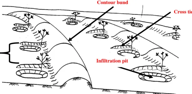
2.4.3. Contour Bunds for Trees
Contour bunds for trees are a simplified form of micro catchments. Construction can be mechanized and the technique is therefore suitable for implementation on a larger scale. As its name indicates, the bunds follow the contour, at close spacing, and by provision of small earth ties the system is divided into individual micro catchments. Micro catchments are simply ditches that concentrate surface runoff around the plant, thus reducing runoff and increasing infiltration to the plant roots.
This system is more economical, particularly for large scale implementation on even land since less earth has to be moved. A second advantage of contour bunds is their suitability to the cultivation of crops or fodder between the bunds. As with other forms of micro catchment water harvesting techniques, the yield of runoff is high, and when designed correctly, there is no loss of runoff out of the system (FAO, 1991).
This system consists of small trash, earth or stone embankments, constructed along the contour lines. The embankments strap the water flow behind the bunds allowing deeper infiltration into the soil. The height of the bund determines the net storage of the structure. The water is stored in the soil profile and above ground to the elevation of the bund or overflow structure (Rebeka, 2006).
Contour bunds for trees are applicable to arid and semi arid areas where rain fall is between 200-700 mm. The topography has to be even without gullies or rills.
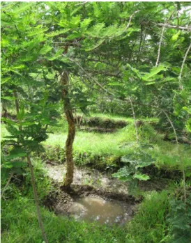
Contour bunds are not suitable for uneven or eroded land as overtopping of excess water with subsequent breakage may occur at low spots. Bunds are formed with soil excavated from an adjacent parallel furrow on their upslope side. Small earth ties perpendicular to the bund on the upslope side subdivide the system into micro catchments.The cross-ties extend upslope from the main bund at an angle of 90° to the main bund; at least 30 cm should be left between the cross-tie and the infiltration pit to allow sufficient space for planting the seedling. Infiltration pits are excavated in the junction between ties and bunds. Excavated soil from the infiltration pit is used to form the ties. The pit is excavated in the junction of the bund and the cross-tie. A pit size of 80 cm x 80 cm and 40 cm deep is usually dug in the furrow above the bund and water collected in the furrow will then drain into the pit and supply the adjacent seedling. Diversion ditch protects the system where necessary. The system is more flexible, because the micro catchment size can be easily altered by adding or removing cross-ties within the fixed spacing of the bunds(FAO, 1991).
14
3. Materials and Method
3.1. Description of the Study Area
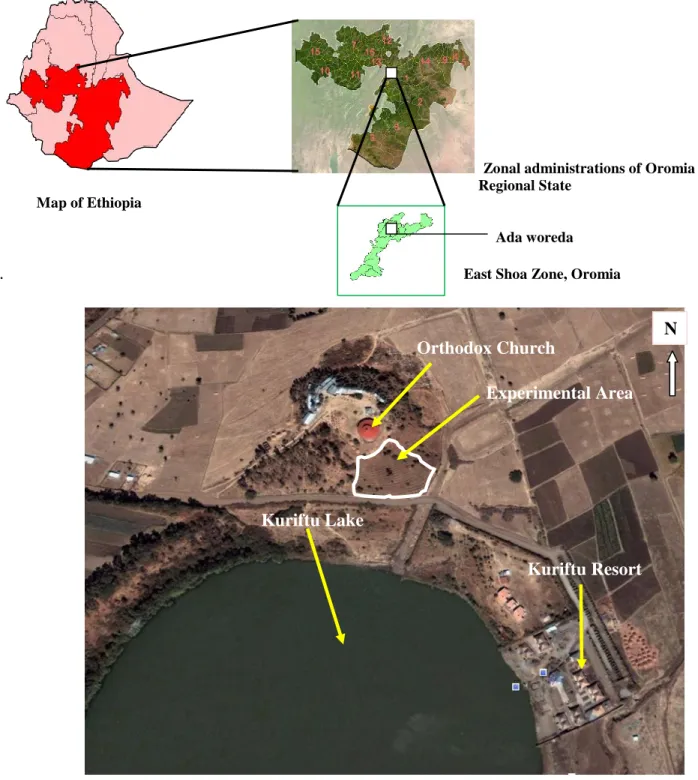
Kuriftu Lake catchment is located in the outskirts of the town of Debre zeit (Bishofftu) some 45km South East of Addis Ababa which is the capital of Ethiopia. It is found at an altitude of 1883mt a.s.l with total annual rainfall and average monthly temperature of 745.6 mm and 18.3 0c respectively for the year 2002(station record). As to its position the lake located at 8046’28”N and 39000’38”E. Lake Kurifftu is among the major lakes of potential scenic value found in the Ada Liben woreda East Shoa zone, Oromia regional state, with an estimated total area of 4 hectare and maximum depth of 6 meter. Unlike many other bigger lakes like Hora and Bishoftu in the proximity of the town of Debre zeit, Lake Kuriftu is not a crater lake with underground water source but the result of accumulation of different seasonal streams that drain out in a very huge depression that gave the lake its shape. It was formed as a result of diverting and damming the tributary of the perennial Mojo River which is Belbela River for irrigation activity in the area. The lake gains water primarily from the Belbela River, with a small contribution from precipitation. Groundwater inflow plays a minor role in the water balance of this lake as the static water level in the area is well below the lake and the occurrence of loss of water through seepage is not well known (Seifu Kebede et al., 2001). During summer small scale irrigation associations pumped out the water from the lake to cultivate vegetables in the nearby flat and fertile lands. This has brought a substantial decline in the water level of the lake and the quality of small fish habitat. However in the year 2007, a resort hotel was built on one portion of the catchment that banned the use of motor pumps for irrigation and the lake receives relatively reduced interference from the nearby population these days.
Presently, the Medhanialem Orthodox church is enclosing the area where this study is conducted. Even though repeated attempts were underway to grow trees of exotic origin on the hills, the majority gave rise to very low survival percentages presumably due to poor moisture reserve for the growing period that continues beyond the rainy season. Seedlings planted on the site for prior observation in the last growing seasons showed a very poor survival rate, too. The site used to be cultivated over and over without rehabilitations.
15
Zonal administrations of Oromia Regional State
Map of Ethiopia
Ada woreda
. East Shoa Zone, Oromia
Figure 2: Location of the study area
Sources: http://www.maplibrary.org/stacks/Africa/
: http://en.wikipedia.org/wiki/Wikipedia_help_desk.
: Google Earth
16
Orthodox Church
Experimental Area
Kuriftu Lake
Kuriftu Resort N
The soil in the study area is basically Andosol. According to Fisseha .I (1992) the major soil types occupying the upper part of topographic position in Debre Zeit are Vertic Andosols which are highly liable to wind and water erosion. Though less is documented about the geology of the soil in the study area it is known that mostly Andosols occur in volcanic regions all over the world and the parent material from which the soils of the study area are developed could be volcanic ash or other volcanic ejecta. The study was conducted on the degraded hillside of the lake catchment within the boundary of the presently enclosed area by the Orthodox Church.
3.2. Description of the Tree Species Selected for Evaluation
It is known that there are a considerable number of species of indigenous origin whose environmental requirements may match with the study area. However, the following five indigenous tree species have been selected for assessment based on two environmental requirements i.e. total annual rain fall and temperature.
Basically the natural growing zone of the species has been taken as a basic selection criterion. Careful attempts have been made to reconcile the environmental requirements of the species with the conditions of the testing site and all of them could qualify as multipurpose trees and shrubs with relatively high tolerances to environmental stress.
All the species can grow from the agro ecological ranges of dry Woyna Dega to Wet Woyna Dega zone according to the traditional (Ethiopian) agro ecological zone classification. Very strictly speaking the study area is in the Dry Woyna Dega agro ecological zone that is characterized by annual rainfall of less than 900mm and altitude range between 1500and 2300. This is SM2-5 i.e. Tepid to cool sub moist plains and plateau (MOA 1998). The following tree species were considered for evaluation of their adaptability on the hillside:
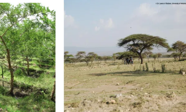
A/ Acacia abyssinica:
It is an indigenous tree species found on woodland or grasslands of the moist and Wet Kolla and Woyna Dega ACZ within the altitude ranges of 500-2000m. Flat- crowned tree 6–15 m high; bark rough and fissured, brown to nearly black Young trees establish ramifying root system before stem growth. The tree is noted apart from other acacias by its umbrella shaped canopy (Azene et al., 1993).
17
Figure 3: Acacia abyssinica in the field
B/ Euclea schimperi:
This is a small indigenous tree/shrub that grows in dry wood land, bush land, riverine forests and marginal arid areas in Dry, Moist and Wet Kolla and Woyna Dega ACZ, with in the altitude ranges of 1500-2300m. The wood is very hard and can be used for firewood, farm tools, live fence, etc. The wood is hard and it coppices (Azene et al., 1993).
Figure4: Euclea schimperi in the field
C/ Olea africana:
This is an indigenous tree species that does best in good forest soils. However it is hardy and drought resistant once established, even in poor soils. It grows in Moist, and Wet Woyna Dega and lower Dega agro climatic zones. It can be used for charcoal, timber, bee forage, milk flavoring. The wood produces a fierce heat on burning and its poles are very durable in the ground (Azene etal., 1993).
Figure 5: Olea africana in the field
D / Dodonaea angustifolia:
This indigenous tree species grows in a variety of habitats from riverine forests to rocky soils or arid marginal areas in Dry and Moist Kolla and lower Woyna Dega AEZ from 1100-1800m. It can be used for windbreak, soil conservation, live fence and firewood. It is evergreen growing 3-8m ht. It is fast growing and usually useful as a tree to reclaim poor land from marshes to sand dunes (Azene et al., 1993).
19
Figure 6: Dodonaea angustifolia in the field
E/ Acacia seyal:
This indigenous tree species grows in Dry and moist Woyna Dega agro climatic zones within the altitude ranges of 1200-2100m.It can be used for fire wood, charcoal, bee forage, nitrogen fixation and soil conservation. It is medium to fast growing and withstands lopping and pollarding. In Western Ethiopia the tree is used as shade to coffee (Azene et al., 1993).
Figure7: Acacia seyal in the field
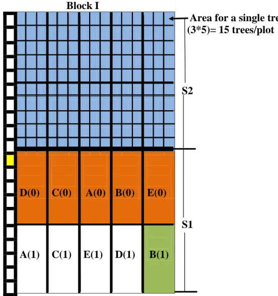
3.3. Experimental Design and Field Layout
The whole study area of the hillside was first classified in to two slope classes. As slope controls runoff and soil water infiltration and hence has impact on seedling establishment it was thus considered as the first factor (factor1) with the two different classes as its levels. The two slope classes identified for this research task were slope class I (0-17%) and slope class II (18-27%) and hence the first factor comprised two levels in it. Classification of the study area in to slope classes was done using the impulse hypsometer that operates through generation of IR radiation.
Species type was considered as the second factor (factor2). It is known that different tree species have variability in coping up with the prevailing condition of the site and stay survived. Accordingly the five different tree species listed in the species description part (section 3.2) were considered as levels for the second factor.
The last factor considered for the research was water harvesting structure.
Different literature sources agree that provision of infiltration pits(Water harvesting structures) assists soil water infiltration on hillsides where runoff tends to persist and cause erosion and low seedling survival rate. Based on this fact the five different species for evaluation were treated under conditions where they were given with infiltration pits as well as without infiltration pits in different slope classes at the time of planting (figure 9). Therefore the last factor was considered to have two levels in it i.e. level zero which referred to a condition where seedlings are planted without infiltration pits adjacent and level one where seedlings were planted with infiltration pits adjacent to them.
Contour bunds for trees, which according to (FAO 1999) are the most simplified forms of micro catchments for better soil and moisture conservation were constructed following the contour over the whole study area. As the name indicates, the bunds follow the contour at close spacing, and by provision of small earth ties (cross ties) the system is divided in to individual micro catchments. To bring alignment of the bunds along the contour the Line level technique was used.
21
Figure 8: Alignment of contour bunds, cross ties and infiltration pits in the field.
Source: FAO, Water Harvesting.AGL/MISC/17/91
To serve the purpose of the experiment various modifications regarding the recommended bund spacing, bund height and size of infiltration pits were made.
After the alignment of the contour bunds was settled with the help of line level and small wooden pegs, contour bunds were made by digging a furrow along the alignment following a somewhat curved path and heaping up the soil down slope.
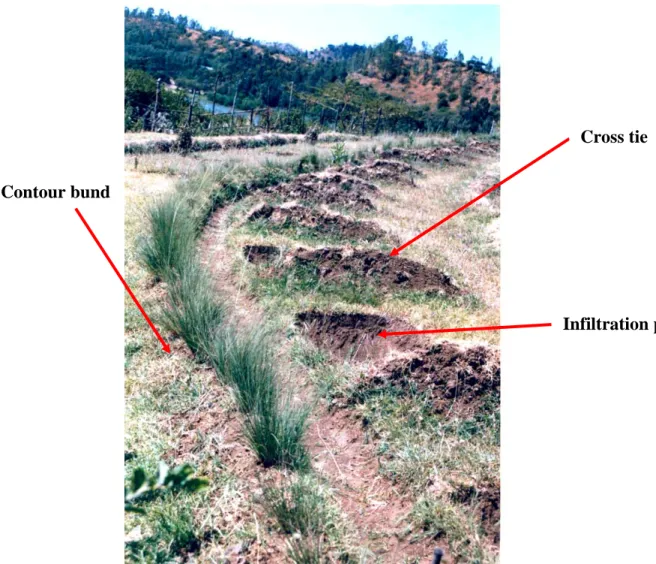
This was followed by compaction and stabilization of the structure by planting grass species and construction of infiltration pits of dimension 40cm*40cm*20cm in each micro catchment area. The soil dug out of the pits was used for the construction of cross ties that point to the contour bund at right angle (figure 8 and figure 9).The junction between the contour bunds and cross ties at the right angle was left open along the furrow so as to minimize the risk of seedling death due to excess water accumulation.
22
Cross tie
Infiltration pit A micro
catchment
Contour bund
Figure 9: Alignment of bunds, infiltration pits and cross ties constructed in the field (1st year. June,2005)
On average a bund height of minimum 25cm for lower slope classes and 30 cm for higher slope classes was maintaind for all the bunds constructed through out the study area based on the recommendation given in most litratures for arid and semi arid areas.The spacing between the bunds was wider(3m) in lower slope classes(0-17%) and narrower(2.5m) in higher solpe classes(18-27%).In this regard the overall recommendation of bund spacing was followed with some modifications for the purpose of making the experimntal area more managable with in the given and available resource and to make it fit to the existing situation of the study area.However there was no overtopping of the bunds with excess runoff and subsequent damage on the earthwork structures encountered throughout the life span of the experiment as a result of adopting a modified bund spacing.The total length of earthwork construction is presented in appendix 1.
23
Cross tie
Infiltration pit Contour bund
The whole study area was then divided in to three blocks. The most appropriate experimental design that handles the variations that arise from the three important factors mentioned earlier in this section is the Split-Split Plot design. Therefore split split plot design was used and the first factor which is slope (S1or S2 )was assigned to the main plot , water harvesting structure(H 0 or H 1) to sub plot factor and species type(A,B,C,D,E) to sub sub plot (split- split plot) factor. As a result there are 3 blocks (I-III) each with 2 main plot treatments (slope class I & slope class II) attached with 2 sub plot treatments (H 0& H 1) and this combination was further attached to 5 treatments (figure 12) which are the five tree species for evaluation (A-E) in split-split plots. The assignment of treatments and levels was carried out through step wise randomization procedure(appendix 3) of the split split plot design .Assignments of factors and levels is also presented in fig.13.
Pure and viable seeds of the selected tree species were collected and their seedlings were raised in the nursery at DZARC using the standard procedures and substrate mixtures in June 2004which is the year ahead of the field work. To come up with an optimum seedling size (about 40cm) of the various tree species for planting 7-10 months were needed in the nursery.
Fifteen seedlings of each species were planted on individual plots of size about 50 sq. m across the slope with a spacing of 1.5 m in the space between the infiltration pit and the crosstie (figures 10 and 11). Planting was carried out after the first runoff had been harvested in June 2005.
24
Figure10: Planting positions for seedlings
Source: FAO, Water Harvesting, 1991
Figure 11: Illustrations of planting positions in the experimental area
25
Olea africana Dodonaea angustifolia
Acacia seyal document or the summary of an interesting point. You can position the text box anywhere in the document. Use the Text Box Tools tab to
change the formatting of the pull quote text box.]
Acacia abyssinica
Figure 12: Field layout and randomization
Tree species:
BLOCK I BLOCK II BLOCKIII A=Acacia abyssinica B=Euclea schimperi C=Olea africana
D=Dodonea angustifolia 0 0 0 E=Acacia seyal
E C D A B E B C D A A C D B E Slope:
S1= Slope 0-17%
S2= Slope 18-27%
S2
Water harvesting:
1 1 1 0=Seedlings planted
Without pits
A B C D E A D C B E E D B A C 1=Seedlings planted
With pit
0 1 0
D C A B E C D A E B D B C E A S1
1 0 1
A C E D B E A D B C C B D A E
Block I Area for a single tree
(3*5)= 15 trees/plot Species: A=Acacia abyssinica B=Euclea schimperi C=Olea africana
D=Dodonaea angustifolia E=Acacia seyal
S2
(0)= Seedlings without pit (1)= Seedlings with pits
S1=Slope class I (0-17%)
S2=Slope class II (18-27%)
Main plot
S1 Subplot
Sub- sub plot
Figure 13: Assignment of treatments within a block in the field
27
D(0) C(0) A(0)
B(0) E(0)
A(1) C(1) E(1) D(1) B(1)
3.4. Data collection and analysis
The major tree characteristics about which data was collected were tree height, collar diameter and survival. For this data collection formats were developed (appendix2&4).The raw field data was then summarized by mean values of 15 trees per plot per species for the variables height, diameter and survival count and then transferred to data summary sheet of split-split plot design prior to subsequent analysis using statistical software.
Data collected on survival, height and diameter of trees starting from the onset of the dry season were then subjected to the Mstat c statistical software for analysis to see if there is significant difference among treatment means at p=0.05. This was carried out by generating ANOVA table using the data for input variables under consideration from summary sheets (appendix 4). Survival percentage values were subjected to logarithmic transformation before parametric tests. This is because in order to apply ANOVA for test of significance among treatment means basic assumptions behind the use of ANOVA have to be fulfilled. Experimental data which comprise whole number such as survival percentage data often tend to follow Poisson distribution where the mean and the variance tend to be equal or proportional giving rise to an unsymmetrical distribution. Such data have to be transformed so that ANOVA becomes applicable. To identify treatment means that are significantly different among each other DMRT test for mean separation at p=0.05 was used.
4. Results
4.1. Height Growth
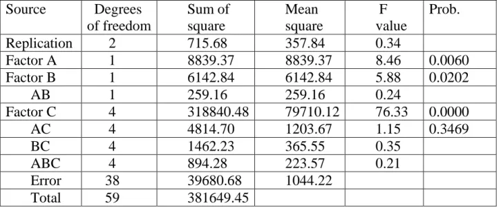
As it can be seen from the ANOVA table (Table 1) there exists significant difference among treatment means with respect to the variable height at P= 0.05.
This implies that under the prevailing conditions of the study area the five different tree species evaluated for their adaptability have shown significantly different performance by widely differing mean heights.
Once significance has been established the next step would be to find which of the means are the most significant ones or the best performing ones in terms of the variable under consideration which is height. This was done through DMRT.
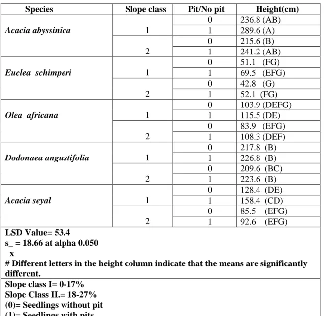
Accordingly Acacia abyssinica with mean height of 289.7cm was the found out to be the best performing tree species(Table 2) in terms of the variable height at P=0.05. The species attained this significantly higher performance in the lower