GEF-6 PIF Template-Aug-2016 1
For more information about GEF, visit TheGEF.org
PART I: PROJECT INFORMATION
Project Title: Sustainable Land Management in target landscapes in Angola’s southwestern region
Country: Angola GEF Project ID:1
GEF Agency: FAO GEF Agency Project ID: 644107
Other Executing Partner: Ministry of Environment (MINAMB) Submission Date: 2 March 2017
GEF Focal Area: Land Degradation Project Duration (Months) 60
Integrated Approach Pilot IAP-Cities IAP-Commodities IAP-Food Security Corporate Program: SGP Name of parent program: N/A (not applicable) Agency Fee ($) 250,774
A.INDICATIVE FOCAL AREA STRATEGY FRAMEWORK AND6OTHER PROGRAM STRATEGIES2 Objectives/Programs (Focal Areas, Integrated Approach Pilot, Corporate
Programs) Trust
Fund (in $)
GEF Project Financing Co-financing LD1 - Program 1 [Agro-ecosystems / Agro-ecological intensification] GEFTF 1,725,726 2,000,000 LD3 - Program 4 [Integrated Landscapes / Scaling-up Sustainable Land
Management through Landscape Approach] GEFTF 914,000 10,000,000
Total Project Cost 2,639,726 12,000,000
B.INDICATIVE PROJECT DESCRIPTION SUMMARY
Project Objective: To reverse negative land degradation trends in selected landscapes in southwestern Angola by combining sustainable and rational approaches to planning, decision-making and land-use stabilization with participatory approaches to capacity building of local stakeholders.
Project Component
Type
3 Project Outcomes Outputs Trust Fund GEF Project (in $)
Financing Co-financing
1. Agro- ecological zoning (AEZ) integrated planning
TA Outcome 1.0)
Improved national capacity for carrying out AEZ analysis, and applying it for sustainable land use planning, making rational decisions on land allocation and for monitoring of land degradation, covering the entire national territory.
Core indicators:
- AEZ central unit is operational and connected to hubs.
- Number of useful AEZ products at different scales (e.g. manuals, maps, a management interface, a user-friendly platform, mobile
1.1. A national data analysis unit
dedicated to Agro-Ecological Zoning (AEZ) is set-up within MINAMB, it is adequately capacitated for serving its purpose and it has good prospect of being sustainably
maintained by project end.
1.2. A fine-scale decision-support system for sustainable land use planning,
ecosystems management, agricultural productivity and suitability is rolled out nationally, producing by end of year 1 useful analyses and GIS planning products upon demand.
1.3 Identification of land-degradation hotspots across the country and adequate long-term monitoring of LDN indicators, including continuous monitoring of status and trends of critical ecosystems services, in coordination with GEF global project on rangeland monitoring (GEF ID 5724).
GEFTF 914,000 2,000,000
1 Project ID number will be assigned by GEFSEC and to be entered by Agency in subsequent document submissions.
2 When completing Table A, refer to the excerpts on GEF 6 Results Frameworks for GETF, LDCF and SCCF and CBIT guidelines.
3 Financing type can be either investment or technical assistance.
PROJECT IDENTIFICATION FORM (PIF)
P
ROJECTT
YPE:
FULL-SIZED PROJECTT
YPE OFT
RUSTF
UND: GEF
TRUST FUND
GEF-6 PIF Template-Aug-2016 2
Project Component
Type
3 Project Outcomes Outputs Trust Fund GEF Project (in $)
Financing
Co-financing
applications etc.), as assessed by users.
- Measures of system robustness (e.g. data security, cohesion and level of normalization).
- Measures of institutional sustainability.
- Young talent nurtured and number of people trained.
1.4. Provincial capitals and selected municipalities (e.g. Bibala in Namibe province, where a new Agro-Ecological center will be eventually operational) serve as ‘two-way hubs’ for the AEZ system, both collecting data for the system and
channeling demand for its products.
2. Sustainable management and
rehabilitation of landscapes
Inv Outcome 2.1)
Pressures on natural resources are attenuated and land productivity is gradually restored within target landscapes, totaling at least 80,000 ha, where land-use will be stabilized and monitored (locations in the provinces of Cunene, Namibe, Huila and Benguela, with exact municipalities to be confirmed during PPG). This is measured through
improvements in Land Degradation Neutrality (LDN) indicators:
LDN indicators:
Proportion of land that is degraded over total land area:
a. land cover and land cover change
b. land productivity c. carbon stocks above and
below ground.
Outcome 2.2)
Farmer-Field Schools (FFS) and Agro-Pastoral Field Schools (APFS) and other community based approaches become effective and widely disseminated ‘vehicles’ of local capacity building, SLM and cooperative landscape- level management, while also contributing to food security in southern Angola (Provinces
2.1. Landscape-level rehabilitation and productivity plans are prepared – and implemented – in a participatory fashion for target landscapes in selected municipalities in Southern Angola, using inputs from the agro-ecological approach and prioritizing core objectives of land-degradation neutrality and land-use stabilization.
2.2 A local landscape governance forum is supported for bringing together decision- makers and stakeholders in each of the target landscapes with the aim of negotiating and endorsing the landscape- level plans, paving the way for making them enforceable and ensuring that that they prime principles of LDN and responsible land tenure governance.
2.3. A network of Agro-Pastoral Field Schools (APFS) and Farmer Field Schools (FFS) is supported to implement a cooperative strategy for multiplying a successful model of knowledge uptake by local community members (including women), with aim of accelerating the land rehabilitation process at the local level.
2.4 A system for monitoring and evaluating field interventions and the effective implementation of the landscape- level plan is set up and it links up to both the AEZ system foreseen under Component 1 and the economic analysis in Component 3 – it also paves the way for implementing land-use plans.
2.5 Multi-tiered SLM training program is institutionalized and delivered through the Bibala Agro-Ecological Center, in Namibe province: (i) SLM in-service certification training program for technical and mid-level management civil servants; (ii) municipal and village level SLM short courses; and (iii) APFS methodology and approach and
GEFTF 1,200,000 8,250,000
GEF-6 PIF Template-Aug-2016 3
Project Component
Type
3 Project Outcomes Outputs Trust Fund GEF Project (in $)
Financing
Co-financing
of Cunene, Namibe, Huila and Benguela).
Core indicators:
- Relevant metrics for assessing the
effectiveness of training and capacity building.
practical trials for SLM to be adapted by communities through APFS.
3. Economic and financial leverage approaches to SLM
TA Outcome 3.0) Project actions under Component 3 increase the availability of funding for, and investments in, land restoration/rehabilitation in Southwestern Angola.
Core indicators:
- Number and types of people trained / sensitized, plus their evaluation of the quality of training sensitization (through surveys) - Number and types of
mainstream and innovative finance options for SLM
3.1. Economic analyses on the cost of land degradation in southern Angola are carried out and disseminated among key decision- makers, with the intention of bringing financial leverage and scale to the actions needed for restoring/rehabilitating land in that part of the country.
3.2 As a follow up on to the study under Output 3.1, both mainstream and innovative finance options for SLM are assessed, explored/probed and enabling action for operationalizing them is taken.
3.3. As a local ramification from
implementing Output 3.2, community-based SLM finance, public-private partnerships and targeted matching grants are designed and implemented (if the availability of direct and specific co-funding to so permits).
GEFTF 400,000 1,750,000
Subtotal 2,514,000 12,000,000
Project Management Cost (PMC)4 125,726 0
Total Project Cost 2,639,726 12,000,000
For multi-trust fund projects, provide the total amount of PMC in Table B, and indicate the split of PMC among the different trust funds here: (__).
C.INDICATIVE SOURCES OF CO-FINANCING FOR THE PROJECT BY NAME AND BY TYPE, IF AVAILABLE
Sources of Co-financing Name of Co-financier Type Amount ($)
Recipient Government Ministry of Environment In-kind 2,000,000
Recipient Government Provincial governments in Southwest Angola In-kind 1,000,000
Recipient Government Ministry of Agriculture In-kind 3,500,000
Donor Agency Multilateral partners yet to be confirmed (under negotiation) Grants 5,000,000
GEF Agency Food and Agriculture Organization Grants 500,000
Total Co-financing 12,000,000
4 For GEF Project Financing up to $2 million, PMC could be up to10% of the subtotal; above $2 million, PMC could be up to 5% of the subtotal. PMC should be charged proportionately to focal areas based on focal area project financing amount in Table D below.
GEF-6 PIF Template-Aug-2016 4
D.INDICATIVE TRUST FUND RESOURCES REQUESTED BY AGENCY,COUNTRY AND THE PROGRAMMING OF FUNDS GEF
Agency
Trust Fund
Country/
Regional/
Global
Focal Area* Programming of Funds
(in $) GEF Project
Financing (a) Agency
Fee (b)b) Total (c)=a+b
FAO GEFTF Angola Land Degradation n/a 2,639,726 250,774 2,890,500
Total GEF Resources 2,639,726 250,774 2,890,500
a) Refer to the Fee Policy for GEF Partner Agencies.
E.PROJECT PREPARATION GRANT (PPG)5
Is Project Preparation Grant requested? Yes [X]
PPGAMOUNT REQUESTED BY AGENCY,TRUST FUND, COUNTRY AND THE PROGRAMMING OF FUNDS
GEF Agency
Trust Fund
Country/
Regional/Global Focal Area* Programming of Funds
(in $) PPG (a) Agency
Fee6 (b) Total c = a + b
FAO GEFTF Angola Land Degradation n/a 100,000 9,500 109,500
Total PPG Amount 100,000 9,500 109,500
F.PROJECT’S TARGET CONTRIBUTIONS TO GLOBAL ENVIRONMENTAL BENEFITS7
Provide the expected project targets as appropriate.
Corporate Results Replenishment Targets Project Targets
2. Sustainable land management in pro- duction systems (agriculture, range- lands, and forest landscapes)
120 million hectares under sustainable land
management 80,000 Hectares
PART II: PROJECT JUSTIFICATION 1)PROJECT DESCRIPTION
1. Summary. Land degradation is a serious threat to ecosystem services and livelihoods in Angola, but there have been very few attempts to systematically address it so far. The extent of land degradation across the national territory, and its impacts on the agricultural economy – including its growth potential – are yet to be assessed. The southwest region is located on the “long fringes” of the Iona Desert’s barren lands. Land cover change in Namibe, Cunene, Huila Provinces, and as far north as into Benguela Province, is intensifying. The region can be considered, at first sight, a “hotspot” for land degradation within Angola. This project focuses on demonstrating a combined approach to both preventing land degradation and rehabilitating already degraded land in Angola’s southwestern region, where the loss of land productivity has been particularly accentuated.
2. More specifically, this project will contribute to reversing negative trends of land degradation in Angola through activities in three main fronts: First, it will build national capacity for analyzing the country’s agricultural potential through Agro-Ecological Zoning (AEZ), delivering a science based, home-grown and interactive system, including with open-access interfaces. AEZ analysis will be used in rational decision-making on land allocation and in the monitoring of land degradation. The scope will be the entire national territory. Secondly, the project will deliver SLM on the ground and thereby decrease pressure on natural resources, putting land in target landscapes (to be specifically selected during PPG, but expected to cover up at least 80,000 ha) into a path of restoration/rehabilitation.
This will be achieved through land-use planning and enforcement, combined with participatory stakeholder consultation and capacity building. Products from the AEZ will be widely used to support decision making on the ground. With a focus on selected landscapes in southwest Angola, the project will demonstrate through practical experiences how land-use can be rationally allocated and stabilized on the basis of existing collaborative and legal frameworks for land-use management and protection. Principles of principles of LDN and responsible land tenure governance will prime the land use planning and implementation work. These local efforts will be underpinned by the upscaling of Farmer-Field Schools (FFS) and Agro-Pastoral Field Schools (APFS) and other community-based approaches. These models for participatory capacity building have been adopted by several development projects, but are relatively new in Angola. FFS and APFS have otherwise been tested, including by FAO, in other countries as and contexts. The Field Schools will serve as vehicles for imparting practical knowledge on SLM, which will be consolidated and widely disseminated at the local level. Thirdly, strategic
5 PPG requested amount is determined by the size of the GEF Project Financing (PF) as follows: Up to $50k for PF up to$2m (for MSP); up to $100k for PF up to $3m;
$150k for PF up to $6m; $200k for PF up to $10m; and $300k for PF above $10m. On an exceptional basis, PPG amount may differ upon detailed discussion and justification with the GEFSEC.
6 PPG fee percentage follows the percentage of the Agency fee over the GEF Project Financing amount requested.
7 Provide those indicator values in this table to the extent applicable to your proposed project. Progress in programming against these targets for the projects per the Corporate Results Framework in the GEF-6 Programming Directions, will be aggregated and reported during mid-term and at the conclusion of the replenishment period.
There is no need to complete this table for climate adaptation projects financed solely through LDCF, SCCF or CBIT.
GEF-6 PIF Template-Aug-2016 5
economics studies will facilitate the identification of most suitable options for SLM finance. Both mainstream and innovative finance may come into play, as the project will attempt to develop relevant partnerships and ensure the ‘trickle-down’ of resources for land restoration (in particular to communities), complementing the efforts towards land degradation neutrality (LDN) developed under the other components. Accent will be put into facilitating access to local finance through partnerships – an element to be further developed during the PPG.
1. The global environmental and/or adaptation problems, root causes and barriers that need to be addressed.
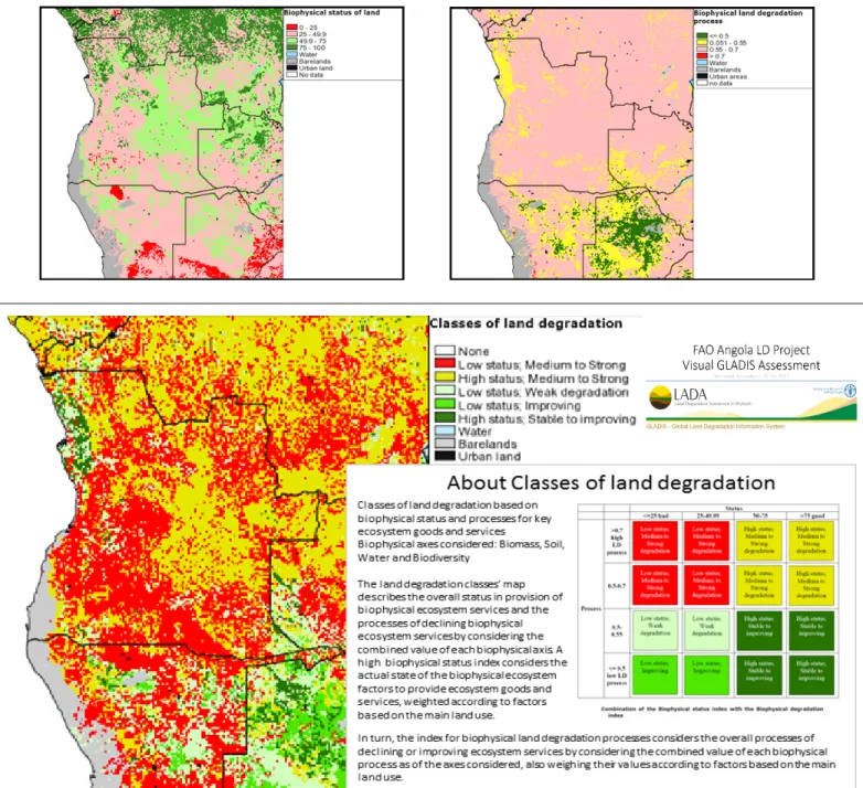
3. Context. With a land surface of 1,246,000 sq km, Angola’s terrestrial ecosystems range from the desert biome of the southwest, through arid savannas of the south, shifting to extensive miombo woodlands in the southeast and in the interior plateau, and to the rainforests of Cabinda, Zaire and other northern provinces. The climate is predominantly tropical and more variable towards the south and center. Vulnerability to climate change impacts is considerable, both with respect to the economy, people’s health and the natural environment. Land degradation affects a large portion of the Angolan territory, but little is known about how it manifests itself, how to prevent it and how to reverse the process, once the more obvious signs of land erosion become visible. A simplified output analysis from FAO’s Global Land Degradation Information System (GLADIS) would e.g. classify approximately 60% of Angola’s land surface as displaying ‘medium to strong’ signs of land degradation and a ‘low status’ for provision of ecosystem goods and services (see Figure 2 in the PIF Annex). Although useful, rich in data and accessible, global assessments like GLADIS are too generic to be of any help.
More accuracy is needed for ‘framing’ the problem of land degradation in specific locations (or even nationally) and for devising solutions. This project will contribute towards these goals.
4. Angola is a country rich in natural resources, notably oil, gas and minerals, but also land, water and varied ecosystems. In Angola’s post war context, the majority of its people are yet to benefit from the country’s natural bounty. The rural areas of Angola still face challenges such as poverty, reliance on subsistence agriculture and limited access to social services.
5. In an effort to diversify the economy away from oil proceeds, the Government of Angola (GoA) is betting heavily on exploiting the country’s agricultural potential, as part of a broad economic development strategy for the current post-conflict recovery era. New investments, bound to come to fruition in the upcoming decade, will certainly help towards this goal. From the government’s side alone, a number of new programs are being mobilized (as it will be elaborated in the finance baseline assessment). In addition, the World Bank is channeling funds for a new investment program. This is backed by government policies for the agricultural sector.
6. The quest towards mainstreaming SLM into the modernization efforts of the agricultural sector in Angola is a complex challenge that the country should aspire to face. This implies ensuring not only that land is used sustainably within this context (that there is no worsening of LDN indicators e.g.), but that also it contributes effectively to food security, to fighting poverty and inequality, while also preserving natural areas and the flow of ecosystem services across landscapes that may be susceptible to land degradation.
7. The region of southwest Angola. For the purposes of this project, the focus region comprises the provinces of Namibe, Cunene, Huila and Benguela, and it is of particular interest for GEF investments. This is where land degradation has a comparatively stronger impact on livelihoods. The combination of a pronounced rainfall variability and poor soils (typical in certain landscapes of southwest Angola), with an inappropriate management of available land resources (soil, fuelwood, grasslands and water) can severely undermine the potential for food production in the region. At the local level, there are signs that this is already happening in certain sites, while in others there is room for a preventive approach.
8. The predominant agro-ecological zones of southwest Angola are generally characterized by a dry climate with an average annual rainfall of 200 mm and a mean temperature of 20-24°C, varying from desert barren lands (parts of Namibe) to drylands (Benguela), while in Huila province the climate presents a variation from dry in the south to humid in the north, where landscapes are dominated by miombo type vegetation.
9. Parts of Huila and Cunene harbor large numbers of livestock raised in systems that range from nomadic to semi-intensive, often in association with sedentary farming. Competition between small holders and commercial farmers is on the increase, with potential conflicts being exacerbated by the presence of returning refugees and internally displaced people (IDPs) reclaiming land tenure rights.
Adding to this, low soil fertility and limited availability of agricultural areas with adequate rainfall currently pose a challenge to the government’s capacity to effectively regulate land access and land use.
10. Furthermore, the Ministry of Environment (MINAMB) is implementing a comprehensive national program to both strengthen the country’s existing protected area (PA) network and create new areas. The priority setting exercise that selected new sites was based on criteria of ecosystem representation (based on vegetation maps) and land availability. In fact, MINAMB counts on GEF support for the purpose. In terms of land use governance, as the PA program progresses, the presence and viability of these protected sites will need to be taken into account in any land allocation decision-making, either at the community, municipal, provincial or national levels.
11. For illustrating the challenges with respect to competition for land in southwest Angola, the following example is instructive.
Serra da Chela is a 20,000 ha site in the process of being established as a new site within MINAMB’s PA strengthening and expansion program. The area is wedged between the towns of Humpata and Bibala, near Huila’s provincial capital Lubango. The area was proposed as a new PA in 2011 for preserving unique afro-montane habitats and for securing valuable ecosystem services downstream. Initial studies that will lead to Serra da Chela’s proclamation are still being carried out, but the presence of a large commercial agriculture undertaking on the volcanic plateau within the polygon initially proposed for Serra Chela has been detected. A decision needs to be
GEF-6 PIF Template-Aug-2016 6
made about the exact shape of the Serra da Chela PA and what would be needed for managing it sustainably (e.g. which trade-offs to consider for the PA to peacefully co-exist with its neighbors). Until then, and similar to other afro-montane sites slated to be protected throughout Angola, Serra da Chela faces significant pressure from the expanding agricultural frontier in the booming southwest part of the country. Land use planning at the landscape level, based on state-of-the art Agro-Ecological Zoning (AEZ) can be instrumental for integrating the presence of new PAs into land-use allocation processes and for resolving through rational decision-making issues of competition for land altogether. Currently MINAMB does not possess these tools.
12. Institutions and management instruments. In the management of land-use in rural areas—and specifically for the target landscapes described further down, where neither mining nor oil exploration are significantly at play—three sets of government entities are particularly important, in addition to provincial and local authorities: (1) the Ministry of Agriculture (MINADER), which not only defines agricultural policies but, is also responsible for managing forest reserves8 and the rural Land Cadaster through subsidiary entities;
(2) the Ministry of Territorial Administration (MAT) and the Ministry of Urban Development and Housing (MUH), due to their central role in statutory commissions responsible for land-use and spatial planning (ordenamento do territorio), along with the recently created National Institute of Territorial Planning and Urban Development (INOTU) under MAT; and last but not least (3) MINAMB, given its mandate for ensuring environmental protection, including the management of protected areas as important features within the landscapes. Furthermore, Agro-ecology and the establishment of Agro-Ecological Centers is an emerging ‘flagship program’ of MINAMB, but tools, collaboration frameworks and in-house capacity are still in the process of being developed.
13. A key legal instrument in the management of landscapes is the 2004 Law on Land-Use Management (Lei do Ordenamento do Território e do Urbanismo), which outlines a number of principles that are well aligned with the objectives of this project and make provisions for enforceable landscape-level planning exercises: (a) protection of core values: environmental, rural, landscape-level, historical, cultural, urban and architectural; (b) rational use of natural resources, ensuring through their (legal) instruments, conditions that are conducive to sustainable use under the regulatory terms of the law; (c) equity; (d) the fair and balanced distribution of lands and the territory; (d) sustainability and intergenerational solidarity; and (e) public participation.
Project target landscapes.
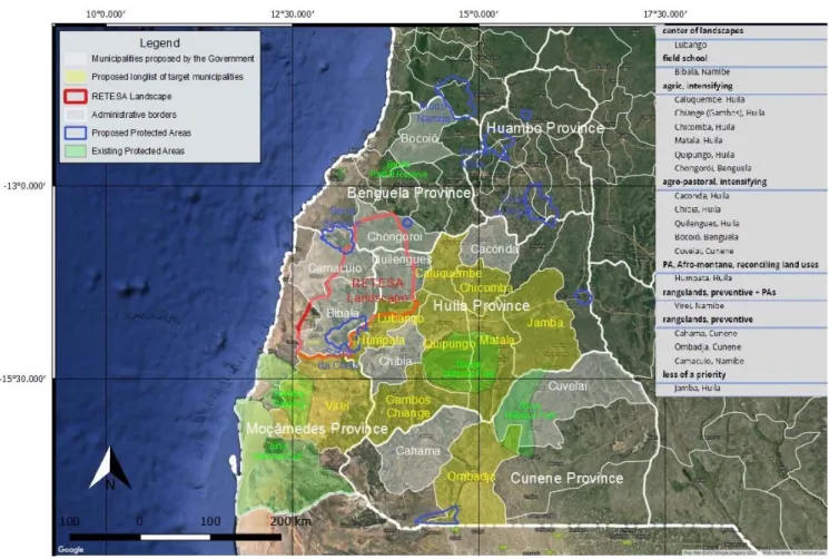
14. Demonstrative landscapes where SLM approaches will be rolled out will be more precisely selected during the PPG. At this stage, a longlist of municipalities has been elaborated and included as harboring potential sites for sustainable landscape-level management through the project. They are located in the Provinces of Namibe, Cunene, Huila and Benguela (see map on the last page of the PIF). Together, they include samples of the different agro-ecological conditions within southwestern Angola and encompass at the same time areas where land degradation is moderate to severe – and land needs to be restored –, as well as other areas where a preventive approach to land degradation is bound to show results. Within the macro-landscape (where demonstration sites will be more precisely selected) there is the presence of protected areas being established and also already existing protected areas. Bicuar National Park and Mupa National Park dominate much of Huila’s landscapes, whereas Iona National Park and Namibe National Reserve are important features in Namibe Province. The integration of these PAs into landscape level planning is important. Population pressure and livestock density are both high in Huila Province, and so is competition for land mostly among smallholders and nomadic tribes in the south (Cunene and Namibe). Drylands abound in Namibe Province and the availability of water resources is dependent on rainfall and rather variable. Bushfires are frequent and land cover change is active in Huila and Benguela, as the agricultural frontier makes its way into more or less intact ecosystems in those provinces.
The extent of Angola’s land degradation problem: Status and Trends
15. Land degradation processes are complex and there are many inter-related drivers and pressures. Generally, it is triggered by drought, population growth, inadequate farming practices, overexploitation of natural resources, urbanization and climate change.
Behind these direct causes are harmful policies and economic drivers.
16. Through a literature review, the 2013 National Adaptation Plan of Action (NAP or PANCOD, after its Portuguese acronym9) concluded, that at least 31.18% of the land surface in Angola is “susceptible to desertification”. This was however based on aridity indicators only and referred to the approximate surface of the country within the arid, semi-arid and sub-humid climatic zones. While one third of the country’s surface is a significant portion of it, the national measure presented in the PANCOD was a mere indication that some areas are more prone to land degradation—and desertification, as an extreme form of it—than others. Also, because of the climate and soil conditions in southwest Angola, the region should be an immediate priority for a land degradation intervention.
However, as previously referred, gauging the extent of land degradation, nationally and locally is a much more complex task. The work under the PANCOD highlighted the difficulties faced by the national experts with respect to making qualified assessments on the matter of land degradation and addressing it effectively through strategies and actions.
17. Beyond the GLADIS’s visual assessment (see Figure 2 in the PIF Annex), a summary analysis, using LDN indicator proxies with available data, is herein presented, aiming at illustrating how land degradation manifests itself in the landscapes of southwestern Angola:
8 Forest reserves, under the purview of MINAGRI, are not part of Angola’s protected area network – even though they could potentially make an important contribution to the conservation of biodiversity and the provision of ecosystem services, including carbon, if they would be sustainably managed.
9 PANCOD - Programa de Acção Nacional de Combate à Desertificação.
GEF-6 PIF Template-Aug-2016 7
18. Loss of vegetation cover, as a proxy for LDN indicators (a) ‘land cover and land cover change’ and (c) carbon stocks above and below ground: Angola is only beginning to properly assess land use change nationally to the extent that it considers benefitting from REDD/REDD+ mechanisms. Currently, there are no comprehensive national systems for monitoring deforestation and forest degradation, which could shed light on the issue of land cover and land cover change, plus carbon stocks.
19. By turning to global assessments, it is notable that between 2001 and 2014 Angola lost some 1.7 million ha of forest coverage (calculated at min. 30% canopy cover) – or an average of 120,000 ha per year – amounting to 3.4% of the total baseline forest cover of 2000.10 This raises concerns, in particular because of the accelerating trend. At the same time, a quick visual analysis of forest cover loss from Global Forest Watch shows that deforestation is a much more serious problem elsewhere in Angola (e.g. Central Plateau, Zaire Province) than in the southwestern region.
20. More careful analysis of land cover change in southwest Angola using forest loss as a proxy would require adjusting parameters to the conditions of miombo woodlands and savannas. By bringing the readings of canopy cover down to min. 10%, the provinces of Namibe, Huila and Cunene would display a loss of forest cover corresponding to 1%, 6% and 1%, respectively, since 2000.
For Huila, the rate is double the national average and therefore significant.
21. Most importantly, the review of the loss of forest coverage highlights the need for a more sophisticated analysis of land cover change. In drylands and grasslands, time series for NDVI readings, upon which most global assessments are based, need to take into account the influence of climatic variability (including seasonal and inter-annual variabilities), as well as the nuances in the types of vegetation cover that may have implications for land degradation assessments. Some global assessments include those parameters, but the scale is often not sufficient fine to corroborate solutions.
22. Additionally, the impacts of livestock on land management parameters should be better analyzed and understood. For agro- pastoral systems in southwest Angola, there is a general risk that overgrazing in certain areas will result in land degradation. However, grazing systems are dynamic and, if well managed, grazing can even be beneficial in terms of land restoration.
23. As for the management of rangelands in southwestern Angola – and here considering only those areas in the drier spectrum of aridity, where only purely pastoralist systems can persist— land use is mostly ‘self-governed’ and follows the traditions of the local tribes that have occupied the area for centuries. Generally, land degradation is less of a problem in those areas, which seem to be in equilibrium. In reality the status and trends are not well studied.
24. Overall, there is a need to understand the dynamics of land cover change in southwestern Angola before proposing solutions for it. It may well be that the arid zones in fringes of the Iona desert are prone to desertification due to poor soils and a harsh climate, while the core desert is simply classified as ‘barren land’. However, if those lands are sufficiently productive to sustain wildlife (and which prompted the creation of a national park in that area), then that land is not degraded. The rapid pace of land conversion observed around Lubango in Huila province, are more likely to lead to loss of carbon stocks overtime, as well as the loss of soil micro-nutrients, resulting in tangible decreases in productivity. That would in turn constitute land degradation.11
25. With respect to carbon metrics, loss of biomass contained in forests, woodlands and grasslands is a good proxy for the loss of carbon stocks above ground. As for below ground carbon, national data is virtually non-existent. At the same time, the carbon found below ground tends to be proportional to the above ground readings – with a few exceptions. One of them are rangelands, where below ground carbon can be surprisingly high, pointing out to the importance of maintaining and restoring pasture. A global assessment on carbon and rangelands showed that many rangelands are dominated by C4 grasses, which are among the most efficient sequesters of atmospheric carbon. Additionally, the majority of rangeland biomass is sub-surface, where it has a high degree of permanence, as long as those lands are not ploughed.12
26. Soil erosion, as a proxy for LDN indicator (b) ‘land productivity’: Loss of top soil causes impacts such as soil sedimentation in streams and rivers, decreasing of soil depth and fertility, altering the soil structure, decreasing soil organic matter, thereby reducing the water holding capacity with consequent leaching of nutrients. Angola’s southwestern region is dominated by soils that are generally susceptible to erosion. In 2006, total soil erosion was assessed by the GoA at approximately 20 million tons per year as a country average. GLADIS assessments show some “red flags” for the Cunene river basin, where water erosion and loss of micro-nutrients should be watched and addressed.
27. Other measures of land productivity such as agricultural yields and livestock conversion rates could be corroborate in the LDN assessment (and could be cited), but aggregate official data for agriculture in Angola is scant, patchy and possibly unreliable. In addition, such data would only be meaningful, if context and purpose specific.
Drivers behind the main causes of land degradation
28. The basic model that summarizes the driving forces of land degradation can be simplified in the diagram in Figure 1 below, which includes direct and indirect causes of land degradation, and where the latter are the drivers behind the process:
10 WRI, Global Forest Watch Portal (http://www.globalforestwatch.org), accessed on 17 Feb 2017.
11 Regarding the subject matter of this paragraph, GLADIS assessments were considered useful for some of those parameters, but less so for others.
12 Tennigkeit and Wilkes, 2008. The authors have e.g. estimated that there is scope globally to rehabilitate 5000 Mha of rangeland which would sequester an additional 1300-2000 MtCO2.
GEF-6 PIF Template-Aug-2016 8
Figure 1. Proximate and underlying driving forces of LD
Source: Adapted from Geist and Lambin (2004) by Davies et al., 2015 [Davies J., Ogali C., Laban P. and Metternicht G., 2015. Homing in on the Range:
Enabling Investments for Sustainable Land Management. Technical Brief 29/01/2015. Nairobi: IUCN and CEM. vi+23p].
29. For this project, all of the drivers apply but to different degrees. The driver analysis is from the 2013 PANCOD, but uses the framework in the above figure. The PANCOD points out to the following main causes of land degradation and desertification in Angola:
farming practices, hunting, deforestation and bushfires. The main degradation types are soil erosion, declining biomass productivity, degradation of soil properties (chemical, physical, and biological), and loss of vegetative cover due to forest clearing for agricultural or pasture conversion or fires. The degradation and desertification processes are perceived by local stakeholders as having the following direct causes (pressures): unsustainable agricultural management, deforestation and unsustainable use of forests, overgrazing in rangelands areas, pollution from mining and lack of rehabilitation of mining areas, and climate change. Socio-economic pressures (indirect causes or drivers) include low level of awareness by both the farmers/herders and local leaders on the economic benefits of soil protection and investments, the degraded state of agricultural equipment and infrastructure (e.g. warehouses, silos, water points), and poverty. All of these are aggravated by the poor provision of extension services.
30. Croplands. The specific dynamics of land degradation in croplands in southwestern Angola can be complex and closely linked to the sustained quality of soils, the availability of water, as well as the agricultural techniques applied. Agricultural systems in southwestern region are varied and it is possible to observe the co-existence of subsistence agriculture practiced by small-holders side- by-side with modern commercial enterprises that aim at supplying remote markets in other parts of the country.
31. Rangelands. Although the dry southern part of Namibe Province has been spared from massive land clearing cycles caused by war displacements—those were otherwise experienced in several other parts of the country—fighting has reduced the areas where pastoralists used to roam. A situation of equilibrium in the management of rangelands can be disturbed by climate shifts and/or competition for land. When the rains are plentiful, there is a tendency towards growth in the livestock population, to the extent that palatable grasses become available. When these are diminished, sustaining the high stock numbers will either require more land or increased mobility – or else, it will result in overgrazing and in the degradation of land as a consequence. Furthermore, commercial cattle ranchers encroach upon traditional grazing lands and cattle corridors are being closed. Finally, perceived expansion of the desert into lands that are marginally suitable agricultural production areas is resulting in less edible pasture and adding further constrains. This can either be a natural phenomenon or man-made.
Solutions and Barriers to be overcome
32. The solution to the problems outlined in the project’s background description is to strengthen the focus on land-use planning, governance and capacity building, in order to favor the sustainable management of land and associated resources across Angola. Where needed, enforcement of applicable compliance measures may come into play.
33. Overall, Angola needs to build on experience with spatial planning and spatial governance in the post-conflict period. The country also needs to strengthen the protection of its ecosystems, both the biodiversity that they harbor and the services that they render.
These are crucial for maintaining land productivity across the landscapes. Angola’s agricultural potential can be gradually realized. This will help the country address not only recurrent food security problems, but also bring income to rural populations eager to engage in production with improved and sustainable techniques. An agricultural resurgence in Angola will also contribute towards diversifying the economy away from the extractive sectors. Southwestern Angola can play an important part in it, according to the agro-ecological vocation of its landscapes. The process of allocating land to realize this solution is best done through rational planning, and decision-
GEF-6 PIF Template-Aug-2016 9
making, based on accurate information made available to decision-makers about the stakes and options at the landscape-level—and, most importantly, through the rule of law.
34. The capacity for supporting the above-described development path is on high demand in today’s Angola, given that, (i) many rural people have been deprived of access to essential social services (including schooling, agricultural extension and rural credit), and (ii) government services are under pressure to improve service delivery, but may not have the means or the human resources needed for it. Both rural communities and government officials therefore face a learning curve before they can master the techniques implied in SLM and apply this knowledge to the management of landscapes. Finally, investment in land productivity is also on high demand in Angola, but the stakes, risks and the expected return on this investment are not well known.
35. In sum, there are two overarching barriers to realizing the mentioned solution within the project landscapes: land-use governance and capacity. Components 1 and 2 refer directly to these. However, because the GEF envelope for this project can be limited, an additional barrier would refer to the finance aspect and this is linked to Component 3.
36. More specifically, a request from the GoA for this project was to bring as much ‘leverage’ as possible to SLM solutions, exactly because land degradation is a very serious and widespread problem in the country. This is true, even if the land degradation problem is not well quantified or assessed in its full parameters – and neither are all the solutions known, especially on the ground, where the context is as diverse as the country’s ecosystems and its ethnic groups. For this reason, the GoA requested that the project should bring about solutions, not just to a few thousand hectares of landscapes, but that it should create powerful and ‘nationally-appropriated’
economic and financial instruments for fighting land degradation.
37. In this light, the following is a summary of the specific barriers that stand in the way for realizing the envisaged solutions:
38. Barrier #1. Capacity for complex and geo-based data handling in Angola is limited.
39. As a concept, SLM is still relatively new to Angola. Notably, the country reported for the first time to the UNCCD in 2013 through the PANCOD. At the same time, the GoA took this as an opportunity to officially endorse the PANCOD as a strategy and action program through a Presidential Decree. The PANCOD points out to major deficiencies in the knowledge base for SLM. Vegetation maps and agro-ecological zoning all date back to the 1970’s. No new comprehensive exercise along those lines has been carried out since.
40. It is understandable that a post-conflict country faces additional capacity challenges. National capacity in general is departing from a low baseline of available education opportunities at all levels—primary, secondary and tertiary—and for the latter, encompassing various subject matters that would be useful in realizing SLM solutions.
41. Clearly, building national capacity for managing and fully exploiting big-data applications cannot be acquired from one day to another. At the same time, within the mining and oil industry, the techniques, applications and geo-based datasets are state-of-the-art.
However, because holding this data and running these applications may constitute a business advantage for oil and mining companies, they tend not to share, not even piecemeal. Although some of the data could, in theory, be of use to the agricultural or environment sector (e.g. soils, contour, vegetation cover), there have been no initiatives towards sharing them for the public good.
42. Another aspect is institutional (which is also related to Barrier #3). The Ministry of Agriculture (MINAGRI) has a clear agricultural development agenda, and possibly regards ‘ecology’ and the need to ensure ‘soil adequacy’ based on agro-ecological conditions as a lower priority. The Ministry of Environment (MINAMB), the proponent of this project, has a different agenda, which includes not just the SLM “flag”, but also biodiversity protection, its mainstreaming into sectoral policies, the adequate management of ecosystem services, climate change and environmental due diligence – to mention a few. Finding common ground in defining the scope of a truly national agro-ecological zoning system, its ramification and subsidiary applications, would require careful negotiations and collaboration with MINAGRI, as well as other sectors – and last but not least also the mining and oil sectors. A key barrier is where to start this process and to have a clear idea of what an AEZ system would entail.
43. Barrier #2. The local capacity for land-use allocation on the ground and SLM has significant gaps.
44. Historically, land-use allocation for agriculture in Angola has followed the path of least resistance until land started to become scarce, inaccessible or degraded. Planning its allocation did not seem necessary during the early days of colonization. Rather, land users occupied productive landscapes with the impression that land and associated resources were almost “endless”. Southwestern Angola remained to a large extent under the control of local tribal groups, who kept (and still keep) their traditions, within which livestock and mobility are of great importance.
45. Once a large exporter of coffee, cotton, sisal, sugar cane, bananas and tobacco, Angola’s agricultural sector suffered widespread destruction during the conflict and has not fully recovered since. Before the war, the country was self-sufficient in all food crops except wheat. The exodus of Portuguese settlers after independence and the ensuing civil war that ravaged the country meant the loss of technical capacity and infrastructure destruction, cutting production areas from markets. This is being gradually addressed through recent infrastructural investments.
46. An added challenge has been the large-scale population displacement in rural areas and the legacy of land mines and unexploded devices (as many as 10 million) – a matter that is a limiting factor for a sustainable development within the agricultural sector, but which is being dealt with through various demining and social inclusion interventions.
GEF-6 PIF Template-Aug-2016 10
47. In today’s Angola, managing and allocating land is much more complex than it has been historically, because of the recent development gains. It means not only re-learning agricultural techniques once mastered, as well as new ones, but in particular it means allocating land in a rational, participatory and equitable manner. The legal frameworks for managing land and associated resources is being developed, but there is still limited practical experience in applying it. A law of note is the 2004 Land Use Planning and Urban Development Law (LOTU - Lei do Ordenamento do Território e Urbanismo), along with its regulations of 2006. The LOTU legal package can be a powerful vehicle for ensuring SLM on the ground, but for which the GoA currently lacks support in implementing and enforcing it in rural areas.
48. Along the same lines of capacity gaps, land managers and land users face many challenges linked to productivity and the dynamics of land allocation at the local level. Local governments are ill-equipped to provide adequate extension services and the current geographical coverage of FFS/APFS is still limited. On the plus side, the approach is more and more accepted and embraced by donors, NGOs as well as the government, but the upscaling of the model and its institutionalization pose additional challenges to national capacity. In addition, local approaches to building the capacity of local farmers and agro-pastoralists lack both adaptability and some form of standardization – even though the curriculum cannot and will not be fully standardized, because it needs to be tailored to local agro-ecological conditions.
49. Barrier #3. Institutional capacity, stakeholder roles and, financial leverage impede the scaling up of SLM approaches.
50. The 2013 PANCOD points out the following about land use governance in Angola: “In a given location, where agriculture is practiced to provide food necessary for the survival of local people, the conversion of natural habitats into agricultural land is perfectly justifiable, as opposed to land-use for wildlife. However, habitats are often destroyed in favor of itinerant agriculture or other short- lived gains, thereby resulting in a loss of ‘wealth’ by these local communities. Particularly in areas where agriculture faces major constraints, the value of land use for wildlife should be more carefully assessed by establishing the gains from ecosystem management, aiming for a more intensive and sustainable use of wildlife, and comparing it against possible compensations for habitat destruction caused by other uses.”
51. The above analysis is useful and instructive, even though it seems to consider only the economic use of wildlife, while both wildlife and intact ecosystems hold value for conservation purposes without the need for deriving economic gains from it. Regardless, the statement makes a very strong point about the need for economic and financial analyses for underpinning decision-making in land- use allocation. Currently, this analysis has not been carried out at scale in Angola, missing out major opportunities of investment in SLM.
52. Under the auspices of the UNCCD, a number of countries are realizing the potential leverage of impact investment geared towards SLM under the LDN initiative. Angola is yet to reform its financial sector to more fully participate in those and other initiatives that can potentially bring home the much-needed finance to restore and rehabilitate landscapes.
53. A new World Bank (WB) project on Commercial Agriculture in Angola summarizes the issue of finance within the sector as follows: “Access to finance is a serious hindrance to commercial agricultural development. Notwithstanding the high credit growth from 2004 to 2014 (going from 5 percent to 22 percent of GDP), the share of credit going to agriculture has remained very low at less than 5 percent of overall credit provided. Additionally, despite the general increase in access to finance over the five years between 2010 and 2014 (with an increase of two-thirds of branches, doubling of ATMs, and tripling of Points of Sale), there has been a clear urban/rural divide in access with Luanda accounting for the bulk of financial sector outreach. Specifically, Luanda, which has 27 percent of the population, accounted for 83 percent of credit, 94 percent of deposits and the majority of bank branches, ATMs and POS in 2015. Government programs such as the Angola Investe, offer subsidized credit, guarantees and a public risk capital fund, however most supported projects belong to non-agribusiness sectors and tend to be concentrated in Luanda. The Angola Development Bank also offers some lines of credit to the agriculture sector. Finally, the enabling environment for promoting agriculture finance (including agriculture insurance, warehouse receipts, equipment leasing, moveable collateral registry) is yet to be developed.”
2. The baseline scenario or any associated baseline projects.
Baseline Programs and Projects.
54. The baseline investment for this project shown below is sub-divided into three main groups, to the extent that they respectively relate to the subject matter of the project’s components. They are namely: (1) land-use governance and institutional / capacity development; (2) investments in the agricultural sector with focus on smallholders in southwestern Angola; and (3) investment in land productivity more broadly.
55. A cursory baseline finance assessment for this project point out to several program, projects and initiatives that are relevant and concur to the same objective as the project. Some initiatives have already been mentioned as the baseline for other GEF projects and are therefore reflected in Section 5 further down, regarding ‘collaboration and synergies’. The Matrix that follows provides an overview of the specific financial baseline for this project and it includes amounts that can potentially provide co-financing to the project, and for which negotiations with the partners are advanced.
GEF-6 PIF Template-Aug-2016 11
Matrix 1. Financial Baseline Overview – rounded-off estimates based on relevance to the project
# Short title, and basic information on baseline interventions Duration
Relevance viz. project's Components
TOTAL
$ million C1) AEZ
C2) SLM
C3) Lever-
age
1
Government of Angola – Central Budget (OGE), estimates in USD covering four central government investment programs that were deemed to be well aligned with the project’s objective for 2017/18: (1) Management of Natural Resources (Programa de Gestão Sustentável dos Recursos Naturais) ($1.4M); Family- farming Agricultural Development Program (Programa de Desenvolvimento da Agricultura Familiar) ($27.9M); (3) Research and Technological Development (Programa de Investigação e Desenvolvimento Tecnológico) ($8.8M); and (4) Strengthening of agricultural Statistics (Reforço das Estatísticas Agrícolas) ($0.9M).
2018-2022 1,2,3 39.0 13.0 13.0 13.0
2
Government of Angola – Central Budget (OGE), rough estimates in USD and projections for provincial allocations for southwestern Angola dedicated to
fighting land degradation at the sub-national level. 2018-2022 3 3.3 3.3
3
WB Angola: Commercial Agriculture Development Project – Pipeline. The program aims to promote commercial agriculture development, increasing production and employment within selected value chains, in targeted areas in Angola – total amount is $230 million, of which $21.1 million is directly relevant to the project.
from 2017 (end date
tbd)
1,2,3 21.0 7.0 7.0 7.0
4
FIIAPP funded by the European Union on improving municipal governance that are working with FAS “Fundo de Acção Social” - 30 M EUR, of which an equivalent to $5M (converted) would be relevant to the FAO LD project, as it relates to the following FIIAPP's Components: (ii) Local Economic Development;
(iii) Strengthening Local Capacities at the Institutional Level.
2015-2020 1 5.0 5.0
TOTAL 68.3 25.0 20.0 23.3
56. Although the above list includes a small count of projects, programs and initiatives, it constitutes a strong financial baseline with investments that will help this project achieve its ambitious goals. At this stage, and based on available information, the financial baseline for this project has been calculated at $68.3 million. The analysis may be refined at PPG stage, as needed.
57. The Current ‘Baseline Scenario’ points out to a strong commitment from the government and partners towards supporting SLM actions in different ways, both directly and indirectly. However, there are visible gaps in the status quo. In the baseline scenario, land degradation will continue to be a visible and serious problem in Angola, but it will remain poorly quantified and assessed. Capacity for SLM on the ground will remain limited and the southwestern region of Angola will face increasing threats to ecosystem services linked to biodiversity, soil, water and carbon. Land will continue to be managed largely in an unsustainable way, even though short-term increases in productivity are possible with certain techniques that may not be fully adequate from an agro-ecological point of view.
Finally, the economics of land degradation in Angola will not be specifically assessed, missing out on opportunities to leverage funding for addressing the tall challenges of land restoration and rehabilitation. These represent major gaps that are linked to the project’s baseline. The GEF intervention is needed to consistently address these gaps.
58. The Theory of Change (TOC) behind the project is summarized in Box 1 in the PIF Annex with a linked figure containing a graphic representation of it.
3. The proposed alternative scenario, GEF focal area strategies, with a brief description of expected outcomes and components of the project
GEF focal area strategies
59. Vis-à-vis the GEF’s Land Degradation Focal Area Strategy for GEF-6, this project aims to enhance the sustainability of land management in Angola in two different fronts. In particular, it will focus on agro-ecological intensification (LD-1) as a key objective.
Activities foreseen under Component 1 are directly linked to the development of national capacity for AEZ. Products from the AEZ will be useful for an informed and rational decision-making process, both nationally, but also on the ground, which will be done through Component 2. Secondly, the Landscape Approach is applied and this justifies the selection of another focal area objective, namely (LD- 3) for scaling-up sustainable land management through the landscape approach. The choice of LD-3 is also highly appropriate for the project, given its Component 2 activities. As for Component 3 it contributes to both LD1 and LD3. Adequate focal area indicators will be selected and assessed, as relevant, during the PPG.
Project Strategy Description / Components
60. Three components are foreseen under the project. They synergistically combine actions towards the project’s objective:
“To reverse negative land degradation trends in selected landscapes in southwestern Angola by combining sustainable and rational approaches to planning, decision-making and land-use stabilization with participatory approaches to capacity building of local stakeholders.” The list of outputs and outcomes are in Part I of this document, where a good level of detail is provided regarding outputs and outcomes. Herein is a description of their purpose per component.
GEF-6 PIF Template-Aug-2016 12
Component 1 Agro-ecological zoning (AEZ) integrated planning
61. Work under Component 1 aims at supporting Angola in building capacity for AEZ analysis, which will be used to assess and monitor land degradation across the country and, most importantly, as a powerful tool for land-use decision-making. The AEZ system, its methodologies and approaches will be primed by rational, scientific and evidence-based ways of working.
62. AEZ can be regarded as a set of core applications, leading to an assessment of land suitability and potential productivity, and a further set of advanced or peripheral applications, which can be built on the inventories and results of the core AEZ studies. Outputs of core applications include maps showing agro-ecological zones and land suitability for different combinations of crops, input levels and water supply, and quantitative estimates on potential crop areas, yields and production. Given the availability of future climatic models and scenarios, projected crop potential productivity is also assessed. Such information provides the basis for advanced applications such as land degradation assessments, livestock productivity modelling, population support capacity assessment and land- use optimization modelling as well as a quantification of the impacts of climate change on the agricultural sector. Economic assessment information that will be produced through Component 3 of the project will eventually also be integrated in the geo-referenced systems.
63. AEZ activities imply the establishment of an Agro-Ecological Central Unit, which will initially gather existing geo-referenced resources on soil, terrain, land cover and climate, as well as on the crop suitability ratings for soil qualities and climatic conditions.
Later, the work may be supported by ‘two-way hubs’ located in selected municipalities (e.g. Bibala in Namibe province, where a new Agro-Ecological center will eventually be operational, or in Cabinda, where another Center was inaugurated in 2016). These will have roles as data collectors and demand channeling centers.
64. The focus of the AEZ Center is a GIS analysis, which will identify combinations of soil, climatic characteristics and landforms etc. and combine these with data on land allocation and land use change and other relevant data. There will be a special focus on LDN indicators. The envisaged decision-support system will handle fine-scale data and produce reports and maps with a focus on sustainable land use planning, ecosystems management and agricultural productivity and suitability. This will imply the following:
Gathering of available geo-referenced data on land resources and associated socio-economic data, including indigenous knowledge and agricultural practices that lead to sustainable landscape rehabilitation and food security.
Spatial estimation of crop suitability and productivity in current and future climatic conditions for relevant crops and identified agricultural practices.
Compilation of a geo-referenced climatic resources in an inventory containing a variety of relevant agro-climatic indicators (NPP, LGP, ET) for current and future climatic projections.
Spatial estimation of yield gaps (difference between potential and actual crop production) to identify suitable areas for sustainable agricultural intensification.
Yielding of standard and customized reports on the above, according to needs and demand.
Maintenance of an open-data platform for the public.
A communication and e-inclusion strategy is implemented in connection with the system,
The training of civil servants in GIS databases and the maintenance of the system for an adequate custody hand-over after the project’s end.
65. Training young Angolan talent to participate in and contribute to the work of the Agro-Ecological Unit and Center(s) is part of the strategy. In addition, from the onset, plans will be made for a sustainable hand-over of the infrastructures, equipment and data to MINAMB by project end—but in particular the capacity (know-how), so the investment can have an impact and be sustainably maintained beyond the project. The engagement of young talent serves the same purpose of ensuring that new institutions created with project funds will be stable and more permanent.
Component 2. Sustainable management and rehabilitation of landscapes
66. The second component of the project has a focus on activities on the ground. It is geared towards not only building capacity at the local level, but also towards applying the decision-making tools that will be produced from the AEZ system.
67. Landscape-level rehabilitation and productivity plans will be prepared in a participatory fashion for each of the selected landscapes targeted by the project. In the long-term, activities are expected to stabilize land use, where a general target for selected intervention areas is expected to reach at least 80,000 ha -- possibly more. This will be more carefully assessed during the PPG.
68. In the municipalities, where the selected landscapes will be located, a specific landscape-level planning legal instrument is foreseen in the 2004 LOTU, Article 28 and it is titled ‘Special Plans’. These are thus described: “Special Plans […] cover areas defined according to specific planning purposes, such as areas of tourism interest, industrial areas, ecological nature reserves, repopulation, defense and security, recovery, reconversion, re-qualification, revitalization, rehabilitation of infrastructure with historical value and remodeling of areas, such as ports and airports”.
69. The above clause fits well with activities envisaged under Component 2, aimed at not just the planning itself, but also the consultations around them with the communities, and the joint implementation of the plans, which can be enforced within the framework