Submitted17 November 2015
Accepted 1 March 2016
Published21 March 2016
Corresponding author
John F. McEvoy, johnfmcevoy@gmail.com
Academic editor
David Johnston
Additional Information and Declarations can be found on page 16
DOI10.7717/peerj.1831
Copyright
2016 McEvoy et al.
Distributed under
Creative Commons CC-BY 4.0
OPEN ACCESS
Evaluation of unmanned aerial vehicle
shape, flight path and camera type for
waterfowl surveys: disturbance effects
and species recognition
John F. McEvoy, Graham P. Hall and Paul G. McDonald
Centre for Behavioural and Physiological Ecology, Zoology, University of New England, Armidale, NSW, Australia
ABSTRACT
The use of unmanned aerial vehicles (UAVs) for ecological research has grown rapidly in recent years, but few studies have assessed the disturbance impacts of these tools on focal subjects, particularly when observing easily disturbed species such as waterfowl. In this study we assessed the level of disturbance that a range of UAV shapes and sizes had on free-living, non-breeding waterfowl surveyed in two sites in eastern Australia between March and May 2015, as well as the capability of airborne digital imaging systems to provide adequate resolution for unambiguous species identification of these taxa. We found little or no obvious disturbance effects on wild, mixed-species flocks of waterfowl when UAVs were flown at least 60m above the water level (fixed wing models) or 40m above individuals (multirotor models). Disturbance in the form of swimming away from the UAV through to leaving the water surface and flying away from the UAV was visible at lower altitudes and when fixed-wing UAVs either approached subjects directly or rapidly changed altitude and/or direction near animals. Using tangential approach flight paths that did not cause disturbance, commercially available onboard optical equipment was able to capture images of sufficient quality to identify waterfowl and even much smaller taxa such as swallows. Our results show that with proper planning of take-off and landing sites, flight paths and careful UAV model selection, UAVs can provide an excellent tool for accurately surveying wild waterfowl populations and provide archival data with fewer logistical issues than traditional methods such as manned aerial surveys.
SubjectsAnimal Behavior, Conservation Biology, Ecology, Zoology
Keywords UAV, Aerial survey, Drone, Disturbance, Flight initiation distance
INTRODUCTION
are heavily reliant upon accurate population counts that are typically taken from manned aerial surveys, particularly in countries such as Australia where water bodies are often ephemeral and widely dispersed (Kingsford, Porter & Halse, 2011;US Fish and Wildlife Service Division of Migratory Bird Management, 2009). To date, most waterfowl surveys of large water bodies are undertaken using fixed wing aircraft carrying trained observers (Kingsford, 1999;Petrie, Shannon & Wilcox, 2002). The reliability of results from aerial surveys can depend on the experience and training of observers, variation in detectability of different species, and the disturbance caused by flying an aircraft over a wetland at low altitude and high speed (Caughley, 1974;Fleming & Tracey, 2008). While there are many advantages to the use of satellite imagery, ground images can often be obscured by cloud or have poor coverage and be difficult to access for researchers in some countries. Satellite imagery is often sufficient for larger taxa, such as several mammal species on the African savannah (Yang et al., 2014) but is considered unsuitable for smaller taxa such as waterfowl (Conant, Groves & Moser, 2007).
In recent years rapid advances in the quality, availability and range of sensors in commercial unmanned aerial vehicles (UAVs) have lead to their widespread use in the fields of ecology and conservation (Anderson & Gaston, 2013;Chabot & Bird, 2015;Goebel et al., 2015;Jones, Pearlstine & Percival, 2006). UAVs can provide a cheaper, safer and less labour intensive approach compared to traditional aerial surveys. While a single survey flight may cover less ground than a standard aerial survey, they can be used to target specific areas of interest with greater precision and with lower workplace safety risks to employees than travel in manned aircraft entails. Applications include biodiversity assessments (Getzin, Wiegand & Schoning, 2012), counting of colonial species (Grenzdörffer, 2013;Ratcliffe et al., 2015;Sarda-Palomera et al., 2012), observations of target species for conservation management (Brooke et al., 2015;Ditmer et al., 2015;Hodgson, Kelly & Peel, 2013;Koh & Wich, 2012;Vermeulen et al., 2013), and fine scale sensing of habitat composition (Chabot, Carignan & Bird, 2014) and environmental variables in inaccessible terrain (Berni et al., 2009). With the increase in the deployment of UAVs particularly in the study of vulnerable or sensitive species, there is a need to balance the potential disturbance to the animals present with the benefits gained from close observation. The application of UAVs for wildlife surveys is a rapidly advancing field and in 2015 alone there have been several studies that have attempted to quantify the response of animals in wild situations to the presence of an overhead UAV (Chabot, Craik & Bird, 2015;Ditmer et al., 2015;Goebel et al., 2015;Pomeroy, O’Connor & Davies, 2015;Vas et al., 2015). In the studies published to date that have examined this question, researchers have often relied on a single type of UAV (typically a small multirotor model) without comparing potential disturbance effects of the different fixed wing and multi-rotor UAVs that are commercially available. Given the different acoustic profiles, flight patterns and shape of available platforms, it would be unwise to extrapolate a focal species’ response or tolerance between different models of UAVs, such as multirotor versus fixed wing configurations, as animals may react very differently to each type.
counted, verified and archived for future analysis or audit. This creates a transparent census technique that increases the usability and cost effectiveness of information gathered if images are made available to other researchers. While aerial photography taken from both manned aircraft and UAVs has proven effective for monitoring large terrestrial mammals (Terletzky & Ramsey, 2014;Vermeulen et al., 2013), identifying much smaller and often more mobile avian taxa to species has thus far proved more challenging. This is particularly true for the identification of waterfowl due to the relative small size of these birds, their camouflaged plumage and similarity in shape and colouration across species (particularly for females and males in eclipse plumage). The acquisition of the high-quality images needed to overcome this challenge has been limited by the resolution and portability of available digital cameras that can be carried by commercially available UAVs.
Recent technological advances appear to have overcome these issues, so the present study had two central aims: (1) To assess disturbance effects on waterfowl from various UAV models that may render a survey invalid, and (2) to assess whether an airborne digital imaging system could provide adequate resolution for unambiguous identification of small bodied waterfowl.
MATERIALS AND METHODS
This work was carried out under scientific permits from the New South Wales Office of Environment and Heritage (licence no.: SL101457) and was approved by the University of New England Animal Ethics Committee (authority no.: AEC14-104).
Study sites
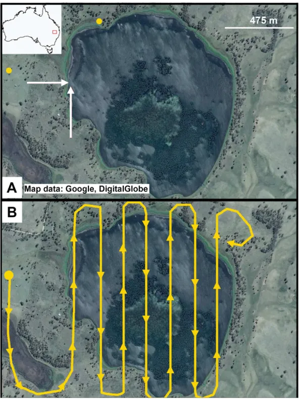
Field tests of disturbance from UAVs were undertaken at two locations in New South Wales, Australia between March and May 2015 with both sites visited on a total of 6 separate occasions. Little Llangothlin Lagoon (Fig. 1) is a permanent natural wetland in the north east of the state (S-30.086277◦, E151.783650◦); it is a protected Ramsar wetland that
provides an important refuge for numerous waterfowl species during drought. The lagoon is 1 km2in area with approximately half of the water surface covered with vegetation. The surrounds are characterised by a narrow band of eucalypt dominated open woodland and agricultural pasture (Fig. 1). Whilst the bird community composition did fluctuate between visits, the same species were observed at each survey and included all typical waterfowl for the region. Total bird numbers regularly exceeded 2,000 individuals, with a minimum of 1,000 ducks seen at each visit. The most common waterfowl observed included Eurasian coot (Fulica atra), Pacific black duck (Anas superciliosa), grey teal (Anas gracilis), hardhead (Aythya australis), Australasian shoveler (Anas rhynchotis), pink-eared duck (Malacorhynchus membranaceus), musk duck (Biziura lobata), blue billed duck (Oxyura australis), and black swan (Cygnus atratus). For a complete species list for each site see supplementary material. While birds were present in every area of the lake, distribution of taxa was not uniform; for example dabbling duck species (Anas sp.) were more common near the shore whilst diving birds and swans preferred open water.
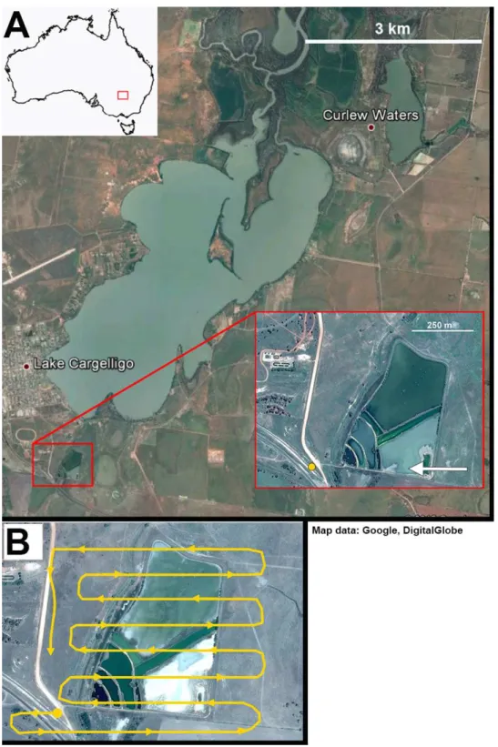
Figure 2 Lake Cargelligo, NSW, Australia.The main lake is approximately 24 km2and is managed to
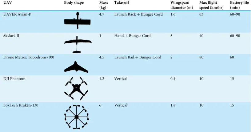
Table 1 UAV models used for test flights and their associated characteristics.
UAV Body shape Mass
(kg)
Take-off Wingspan/ diameter (m)
Max flight speed (km/hr)
Battery life (min)
UAVER Avian-P 4.7 Launch Rack+Bungee Cord 1.6 63 60–90
Skylark II 4 Hand+Bungee Cord 3 40 60–90
Drone Metrex Topodrone-100 4.5 Launch Rail+Bungee Cord 2 80 60
DJI Phantom 1.2 Vertical 0.4 10 15
FoxTech Kraken-130 6 Vertical 1.8 10 15
managed by local authorities to maintain consistent water levels year round. The main lake supports populations of Australian pelican (Pelecanus conspicillatus) and Australian darter (Anhinga novaehollandiae) but the majority of waterfowl in the region congregate at the adjacent sewage works (Fig. 2). Sewage ponds are rich in nutrients and protected from disturbance and often form a focal point for waterfowl in many areas of Australia (Hamilton & Taylor, 2004;McEvoy et al., 2015;Murray et al., 2012). The sewage works (0.2 km2) consists of constructed ponds of varying turbidity separated by gravel embankments that provided areas for roosting of waterfowl, surrounded by a dense border of Typha spp. rushes. Bird numbers at the sewage works remained stable at approximately 40 individuals at each visit with species including grey teal, pink-eared duck, Pacific black duck, hardhead, and black swan. During the day the majority of waterfowl were found basking on embankments between ponds rather than on the water surface, providing a contrast to the Little Llangothlin Lagoon site. Both study sites were regularly visited by a range of avian predators including white-bellied sea-eagle (Haliaeetus leucogaster), marsh harrier (Circus approximans), and whistling kite (Haliastur sphenurus), all of which prey on small bodied waterfowl (Baker-Gabb, 1984;Marchant & Higgins, 1990). None of the species at either site were observed to be breeding.
UAV models and flights
(Table 1). These models included fixed wing UAVs with different wing profiles (e.g., delta wing, glider type) and multirotor UAVs from the small, widely used DJI Phantom quadcopter to the larger, more powerful Kraken-130 multirotor UAV (Fig. 3). Each UAV had a unique take-off and landing system, with fixed wing systems requiring a larger clear area for both take-off and landing, launching systems such as bungee cords or rails along with landing airbags, parachutes or nets. The multirotor models could take-off and land vertically from almost any location. Flight time and flight speed also varied between UAV models. Flight time for the fixed wing models was between 60 and 90 min per flight, whereas flight time for multirotor models was often <20 min per flight. Fixed wing UAVs moved at a speed of approximately 40 km/hr while multirotor UAVs moved at approximately 5 km/hr.
At Little Llangothlin Lagoon UAVs were launched from two sites; one within 10 m of the shore and another 500 m from the shore with the latter behind a small rise and thus out of sight of birds on the lagoon. UAVs were launched either directly towards flocks of birds on the lagoon or approached the lagoon at a tangential angle (Fig. 1). Flights were undertaken at a maximum altitude of 120 m and a minimum of 40 m above the lagoon. During flights, each UAV was programmed to fly across the lagoon in a linear north-south direction at a given altitude before changing in altitude by 10 m over land approximately 50 m from the lagoon edge and returning on the opposite north-south route for the next pass (Fig. 1). Altitudes were tested in ascending and descending order to determine if the birds responded differently to the UAV initially entering the area at lower or higher altitudes. Each UAV undertook two test flights for each combination of approach angle and take-off conditions.
At Lake Cargelligo UAVs were launched from a clear site 300 m from the edge of the water out of sight of the birds. Flights were all launched away from the birds due to prevailing wind conditions and flight paths were flown parallel to the embankments where most birds were found. As at Little Llangothlin Lagoon, each UAV carried out a range of passes at ascending and descending altitudes between 120 m and 40 m. Each UAV undertook two test flights for each combination of approach angle and take-off conditions. The Phantom multirotor UAV showed poor results, with birds swimming away from the UAV such that they were not captured on images taken vertically below the unit (Table 2). Further, this unit’s battery life saw it incapable of carrying out a full survey of the lake and as such it was not used in further flights. Due to time constraints, technical problems with the UAV operators’ equipment, and poor weather conditions, some UAVs were not used at both sites (Table 4). The Kraken multirotor UAV was tested at Lake Cagelligo, while the Avian-P, Topodrome-100 and Phantom multirotor were tested at Little Llangothlin Lagoon. The Skylark UAV was tested at both locations. The total number of birds at Lake Cargelligo was smaller (as the water body was not as large) but the same species were recorded and the UAV was tested over a wild, mixed flock of birds.
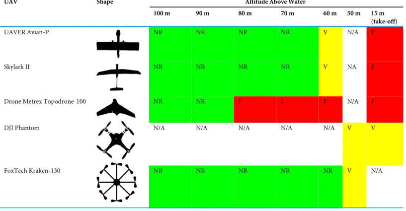
Table 2 Response of mixed flocks of waterfowl to UAVs of different shapes flying overhead at various altitudes.For fixed wing UAVs the lower altitudes (15 m) represent take-off where the UAV was launched directly towards the birds before gaining height. NR (green squares)=No dis-cernible response, V (yellow squares)=Vigilance response detected, F (red squares)=Flight response. Cells are marked ‘‘N/A’’ where a given UAV did not fly over birds at that altitude.
UAV Shape Altitude Above Water
100 m 90 m 80 m 70 m 60 m 50 m 15 m (take-off)
UAVER Avian-P NR NR NR NR V N/A F
Skylark II NR NR NR NR V NA F
Drone Metrex Topodrone-100 NR NR F F F N/A F
DJI Phantom N/A N/A N/A N/A N/A V V
FoxTech Kraken-130 NR NR NR NR NR V N/A
categories: ‘‘NR’’ was used if birds showed no discernible response to the UAV, ‘‘V’’ was used if birds ceased foraging, either orientating or looking towards the UAV or, in some cases, slowly swimming away from the stimulus, or ‘‘F’’ if birds took flight in response to the approaching UAV. No differences in disturbance measures were observed according to whether the UAV was descending or ascending at each pass; hence for simplicity presented results combine both vectors (Table 2).
Digital imaging
Table 3 Specifications of camera models used in test flights.
Camera UAV Focal
length
Resolution (megapixel)
Sensor
Sony RX-1 UAVER Avian-P & Drone Metrex
Topodrone-100—Fixed Wing
35 mm 24.3 Full Frame CMOS
mvBlueCOUGAR-X Skylark II—Fixed Wing 100 mm 10.1 Full Frame CCD
Sony A7-R FoxTech Kraken-130—Multirotor 35–70 mm 36.4 Full Frame CMOS
Phase 1 FoxTech Kraken-130—Multirotor 80 mm 50 Medium Format CMOS
GoPro Hero Video Camera DJI Phantom—Multirotor 21 mm 5.0 CMOS
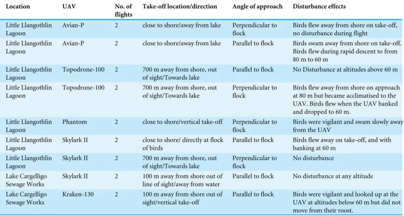
Table 4 Disturbance effects on mixed flocks of waterfowl for UAVs launched from different take-off sites and flown at various approach an-gles.UAVs were flown either directly perpendicular to a sitting flock of birds or in a tangential flight path running parallel to the main flock of birds. Survey location involved birds at either a large (Llangothlin) or small (Cargelligo) water body.
Location UAV No. of flights
Take-off location/direction Angle of approach Disturbance effects
Little Llangothlin Lagoon
Avian-P 2 close to shore/away from lake Perpendicular to flock
Birds flew away from shore on take-off, no disturbance during flight
Little Llangothlin Lagoon
Avian-P 2 close to shore/away from lake Parallel to flock Birds swam away from shore on take-off. Birds flew during rapid descent to from 80 m to 60 m
Little Llangothlin Lagoon
Topodrone-100 2 700 m away from shore, out of sight/Towards lake
Parallel to flock No Disturbance at altitudes above 60 m
Little Llangothlin Lagoon
Topodrone-100 2 700 m away from shore, out of sight/Towards lake
Perpendicular to flock
Birds flew away from shore on approach at 80 m but became acclimatised to the UAV. Birds flew when the UAV banked and dropped to 60 m.
Little Llangothlin Lagoon
Phantom 2 close to shore/vertical take-off Perpendicular to flock
Birds were vigilant and swam slowly away from the UAV
Little Llangothlin Lagoon
Skylark II 2 close to shore/ directly at flock of birds
Parallel to flock Birds flew away on take-off, and with banking at 60 m
Little Llangothlin Lagoon
Skylark II 2 700 m away from shore, out of sight/Towards lake
Perpendicular to flock
No disturbance
Lake Cargelligo Sewage Works
Skylark II 2 100 m away from shore out of line of sight/away from water
Parallel to flock No disturbance at any altitude
Lake Cargelligo Sewage Works
Kraken-130 2 100 m away from shore out of sight/vertical take-off
Parallel to flock Birds were vigilant and looked up at the UAV at altitudes below 60 m but did not move from their roost.
to determine the species present in each image. If there was not unanimous agreement between the three authors as to the species shown in a given image, it was considered to be unusable.
RESULTS
Disturbance
launched directly at a flock of birds at a low altitude during take-off (10–15 m). During the course of the study, resident raptors were observed to fly across both study sites, actively hunting at similar altitudes to those flown by the UAVs. These raptors elicited immediate flight responses from the flocks of waterfowl present with most birds on the lake taking flight as the raptors flew overhead. The flight response to the UAVs, when it did occur, included birds flying away from shore at low altitude for short periods to settle on open water. In contrast, the response to the arrival of a raptor was far more marked with large flocks of birds taking flight and flying for longer periods high above the water before resettling.
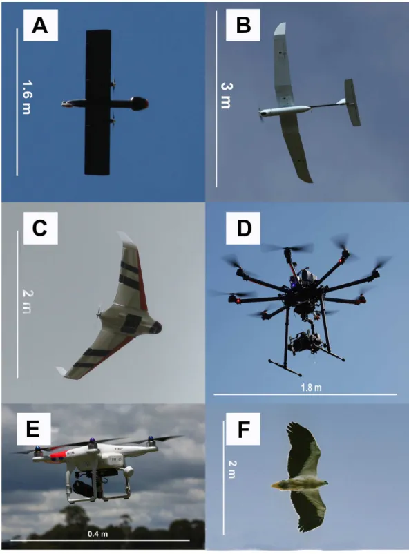
The shape and wing profile of each UAV model appeared to influence the response of waterfowl. The UAV with a delta-wing design (Topodrone-100) caused the greatest level of disturbance and flee behaviour (Tables 2and4), particularly when it directly approached birds during take-off, or in a direct rather than tangential path (≤80 m altitude), or made a banking manoeuvre while changing altitude (dropping from 70 m to 60 m, for example). These flight periods resemble those of a swooping raptor that is banking to swoop upon prey and the design of the UAV to human eyes was very similar in dihedral angle and shape to that of the larger raptors hunting waterfowl (Fig. 3F).
Disturbance from multi-rotor UAVs was more subtle; the DJI Phantom multirotor when flown at 15 m altitude, resulted in birds swimming away from the UAV when approached. Birds remained vigilant and continuously swam ahead of the field of view of the on-board video camera without taking flight. The larger 8-rotor system (Kraken-130) caused little disturbance at any altitude. The only recorded response occurred at 40 m altitude where roosting birds could be seen to tilt their heads to look up at the UAV, but no further response was noted and birds continued roosting or preening activities (see Pacific black duck inFig. 4).
Digital imaging
Of the four different camera systems that were trialled only two configurations provided adequate results. The Phase 1 medium format camera equipped with an 80 mm lens and 50 megapixel sensor produced images of high resolution (Fig. 4, ground cover=5.5 mm/pixel at 60 m altitude) that allowed for the unambiguous identification of very similar species of ducks, as well as smaller non-target species including passerines. The Sony A7-R camera with a 36 megapixel sensor and 50–70 mm lens provided images of comparable resolution to the Phase 1 with a slight but noticeable reduction in resolution (Fig. 5, ground cover=7.2 mm/pixel at 50m altitude). The other camera systems suffered from either a lack of resolution (e.g., the Sony RX-1, ground cover=25 mm/pixel at 60 m altitude)
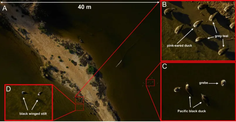
Figure 4 Examples of images taken using the Phase-1 medium format digital camera.Species that are similar in size and shape can be clearly dif-ferentiated in photos taken from 60 m above the flock with an 80 mm lens (A and B). Smaller birds such as grebes and black winged stilts can also be easily identified (C and D). A Pacific black duck can be seen tilting its head to look directly up at the camera (C). This image was captured with an ISO=400, shutter speed=1/800 s and f-stop=11. The area footprint of this image is 40 m× 30 m with ground coverage of 5.5 mm/pixel.
sun, or glare from the water surface reached the lens. As a result, this camera provided very poor-quality images that were not suitable for species identification.
DISCUSSION
Many studies have quantified anthropogenic disturbance to wild birds from stimuli such as pedestrians and vehicles (McLeod et al., 2013;Moller et al., 2014). With the increasing popularity of UAVs for ecological research in the past year, there has been a sharp increase in papers assessing the potential for disturbance of wild animals by UAVs (Ditmer et al., 2015;Dulava, Bean & Richmond, 2015;Pomeroy, O’Connor & Davies, 2015;Vas et al., 2015;
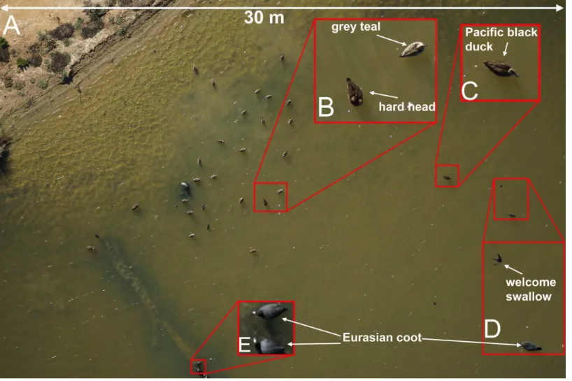
Figure 5 Examples of images taken using the Sony A7-R digital camera.Species that are similar in size and shape can be clearly differentiated in photos taken from 50 m above the flock with a 70 mm lens (A, B and C). Smaller birds such as swallows and coots can also be easily identified (D and E). The area footprint of this image is 30 m×20 m with ground coverage of 7.2 mm/pixel. This image was captured with an ISO=200, shutter speed=1/640 s and f-stop=6.3.
minimal. With the rapid increase in the application of UAVs for ecological research it is important to gain a broader understanding of their disturbance impacts on different species in wild situations. Our study builds on these results and is the first to directly compare the disturbance effects at two different sized water bodies from a range of camera equipment, including low- to high-end consumer cameras as well as a professional medium-format aerial camera. The UAVs tested in this study cover a range of body shapes and wing profiles that may be deployed for ecological fieldwork. We tested these UAVs in a natural setting with large mixed flocks of different species of water birds and observed that multirotor UAVs had minimal disturbance effects. However, fixed-wing UAVs performed better in collecting aerial photography and were more practical to deploy for larger scale surveys as long as they were flown in a manner that minimised the potential for disturbance.
an effective solution for aerial surveys of waterfowl populations (Table 2). Our findings demonstrate that if take-off and landing occur out of sight of the target species and the UAV has reached its survey altitude before crossing into view of the birds, disturbance should be minimal with in-flight noise quieter than manned fixed-wing aircraft (Fleming & Tracey, 2008). Mixed-species flocks of wild birds were observed to take flight in response to a UAV that was launched from the take-off site toward the flock at low altitude (<40 m). Birds were observed to tolerate a UAV descending from 120 m to 40 m altitude but only if any banking manoeuvres while turning and descending did not occur directly above the flock (Table 4).
It has long been thought that birds, and waterfowl in particular, react differently to silhouettes of predators (e.g., raptors) and non-predators (e.g., geese) flying above them. Early studies (Tinbergen, 1939) found that naïve birds reacted differently to ‘hawk’ and ‘goose’ silhouettes but these findings were later re-assessed (Schleidt, Shalter & Moura-Neto, 2011) and found to be a reaction to novel shapes that disappeared with experience. The outline of the 4 and 8 rotor multirotor UAVs used in this study represented novel shapes that did not resemble any identifiable bird group to our eyes. These UAVs caused no flight response in waterfowl with only a mild swimming response at very low altitudes (15 m). Two of the fixed wing UAVs used in this study, in particular the ‘‘Avian-P’’ model (Fig. 3A), presented an outline that closely resembled that of a non-predatory swan to human observers experienced in waterfowl identification. These ‘glider-type’ UAVs caused no disturbance to large flocks of waterfowl when flown overhead at a steady altitude including flights at the lower limit of the UAV (60 m above water level). The delta-wing type UAV (Fig. 3C) presented an outline resembling raptors that regularly hunt waterfowl at the study sites, particularly when banking and changing altitude, where it caused birds to fly away from the shore toward open water. This is a typical response to a swooping raptor for these species (J McEvoy, pers. obs., 2015). This study afforded us the opportunity to observe responses to actual avian predators as well, including white-bellied sea eagles (Fig. 3F) that have a very similar wingspan and wing shape to the UAVs used. Even though some UAVs had a passing resemblance in silhouette to predators, the arrival of an actual predator resulted in a mass take-off of the mixed flock of birds that was more marked than UAV-evoked responses. Our findings suggest that even though UAVs represent novel objects in the air, wild birds do not react to them as strongly as they do to typical aerial predators.
the commercial UAV industry we found that many of the UAV companies are, at least in south-eastern Australia, focused on industrial applications such as mining or civil engineering projects that have vastly different technical requirements to most ecological fieldwork. As a consequence, one of the initial barriers to effectively carrying out aerial surveys of this kind was in communicating effectively with commercial UAV operators the different requirements of working with mobile taxa as opposed to collecting imagery of static geographical features. Future researchers should bear this in mind and have detailed conversations with companies concerning disturbance, approach angles, and take-off and landing sites to avoid costly delays and inaccurate data collection.
High resolution digital images allowing the easy identification of waterfowl species were produced by both the Phase-1 camera (Fig. 4) and the Sony A7-R (Fig. 5) in our trials. Although the images produced by the Phase-1 were of a noticeably higher resolution, the much greater cost (approximately AU$40,000) and size may prove prohibitive for many researchers. Large multirotor UAVs are capable of carrying heavy payloads and can take-off and land vertically in almost any terrain without causing disturbance to waterfowl. However, their current short battery life seriously limits their feasibility for surveys of large areas including even moderately sized water bodies. Single rotor UAVs capable of vertical take-off and landing have been deployed with flight times close to 30 min and faster air speeds than many multirotor systems (Drever et al., 2015) but these UAVs are not as widely available to researchers. Despite this, the low disturbance effects of these UAV designs mean that researchers should consider their use if the current constraints of these models are not too restrictive and a suitable flight time/camera payload can be used.
One of the biggest advantages of using UAVs to collect high-quality digital images is that it allows researchers to archive the results of each survey for future reference, re-assessment, validation, or meta-analysis. While automated systems for counting birds from aerial photographs have been in use for some time (Bajzak & Piatt, 1990), they are generally limited to counting individuals of a single species or colonial birds showing strong contrast with their visual background (Abd-Elrahman, Pearlstine & Percival, 2005;Descamps et al., 2011;Groom et al., 2011;Trathan, 2004). The task of automatically identifying species of similar size, shape, and colouration from large mixed flocks remains a serious challenge to overcome. Developing versatile algorithms to identify and count a variety of waterfowl species in different habitat settings will be a key area of future research in this field.
When attempting to accurately identify waterfowl to species level using UAV photography there are many trade-offs that must be considered. Ideally, using a very high resolution camera such as the Phase 1 medium format camera (50 megapixels) allows the UAV to fly at higher altitudes covering a large area footprint (40 m×30 m at 60 m
the Sony A7-R camera (36 megapixels) with a 70 mm lens at 50 m altitude and captured images that allowed for easy identification of waterfowl to species (Fig. 5) with a slight reduction in the area footprint of each image (30 m×20 m). Further trade-offs occur with the choice of UAV when considering the ability of the UAV to survey a large water body in a short period of time, the ability to carry the necessary camera equipment, and whether the shape, wing profile, or flight behaviour of the UAV are likely to disturb the target animals.
Based on our findings, the best results for successfully surveying a medium sized (>1 km2) wetland and easily identifying waterfowl would come from a combination of a digital camera with a minimum 36 megapixel full-frame sensor combined with a fixed wing UAV with long straight wings to cover large wetlands in a single survey. That is not to say that other combinations of UAVs and cameras are unsuitable, but that this combination appears to offer the longest flying time combined with high-quality imagery suitable for species identification at an approximate resolution of 7.2 mm per pixel that was required to achieve our desired accuracy in identification. Prior to deployment, careful consideration should be given to all of the trade-offs mentioned above before embarking on a waterfowl survey using UAVs as different conditions or availability of hardware may necessitate a slightly different approach. Where possible, the take-off and landing sites should be carefully selected to remain out of sight of the target birds and flight paths should be programmed to approach tangentially to the main flock of birds. Where possible, any turning manoeuvres or sharp drops in altitude should be performed away from the shore with the UAV flying at a fixed altitude across the study area to minimise any potential for disturbance.
ACKNOWLEDGEMENTS
UAV surveys were carried out with the assistance of a number of commercial companies: UAV Geomatics Australia, Airsight Australia, Flight Data Systems, and UAViation Australia. We are indebted to the National Parks and Wildlife Service, NSW and Lachlan Shire Council for their assistance with accessing study sites. We are grateful to a number of people for their assistance with field work: Koen Dijkstra, Milla Mihailova, Ahmad Barati, Louise Streeting, Sigrid Mackenzie and Alice Bauer.
ADDITIONAL INFORMATION AND DECLARATIONS
Funding
The study was funded by the New South Wales Department of Primary Industry through a grant provided to PM and GH. The funders had no role in study design, data collection and analysis, decision to publish, or preparation of the manuscript.
Grant Disclosures
Competing Interests
The authors declare there are no competing interests.
Author Contributions
• John F. McEvoy conceived and designed the experiments, performed the experiments, analyzed the data, wrote the paper, prepared figures and/or tables, reviewed drafts of the paper.
• Graham P. Hall conceived and designed the experiments, performed the experiments, reviewed drafts of the paper.
• Paul G. McDonald conceived and designed the experiments, performed the experiments, contributed reagents/materials/analysis tools, reviewed drafts of the paper.
Animal Ethics
The following information was supplied relating to ethical approvals (i.e., approving body and any reference numbers):
This work was approved by the University of New England Animal Ethics Committee (authority no: AEC14-104).
Field Study Permissions
The following information was supplied relating to field study approvals (i.e., approving body and any reference numbers):
This work was carried out under scientific permits from the New South Wales Office of Environment and Heritage (licence no.: SL101457).
Data Availability
The following information was supplied regarding data availability:
The research in this article did not generate any raw data beyond what is presented in the manuscript text.
Supplemental Information
Supplemental information for this article can be found online athttp://dx.doi.org/10.7717/ peerj.1831#supplemental-information.
REFERENCES
Abd-Elrahman A, Pearlstine L, Percival F. 2005.Development of pattern recognition
algorithm for automatic bird detection from unmanned aerial vehicle imagery.
Surveying and Land Information Science65:37–46.
Allan BM, Ierodiaconou D, Nimmo DG, Herbert M, Ritchie EG. 2015.Free as a drone:
ecologists can add UAVs to their toolbox.Frontiers in Ecology and the Environment
13:354–355DOI 10.1890/15.WB.015.
Anderson K, Gaston KJ. 2013.Lightweight unmanned aerial vehicles will revolutionize
spatial ecology.Frontiers in Ecology and the Environment 11:138–146
Bajzak D, Piatt JF. 1990.Computer-aided procedure for counting waterfowl on aerial photographs.Wildlife Society Bulletin18:125–129.
Baker-Gabb D. 1984.The feeding ecology and behaviour of seven species of raptor
over-wintering in coastal Victoria.Wildlife Research11:517–532DOI 10.1071/WR9840517.
Bako G, Tolnai M, Takacs A. 2014.Introduction and testing of a monitoring and
colony-mapping method for waterbird populations that uses high-speed and ultra-detailed aerial remote sensing.Sensors14:12828–12846DOI 10.3390/s140712828.
Bartlam-Brooks HLA, Beck PSA, Bohrer G, Harris S. 2013.In search of greener
pastures: using satellite images to predict the effects of environmental change on zebra migration.Journal of Geophysical Research: Biogeosciences118:1427–1437
DOI 10.1002/jgrg.20096.
Berni JAJ, Zarco-Tejada PJ, Suarez L, Fereres E. 2009.Thermal and narrowband
multispectral remote sensing for vegetation monitoring from an unmanned aerial vehicle.IEEE Transactions on Geoscience and Remote Sensing47:722–738
DOI 10.1109/TGRS.2008.2010457.
Blanco PD, Rostagno CsM, Del Valle HcF, Beeskow AM, Wiegand T. 2008.Grazing
impacts in vegetated dune fields: predictions from spatial pattern analysis.Rangeland Ecology & Management 61:194–203DOI 10.2111/06-063.1.
Bregnballe T, Speich C, Horsten A, Fox AD. 2009.An experimental study of numerical
and behavioural responses of spring staging dabbling ducks to human pedestrian disturbance.WildfowlSpecial Issue 2:131–142.
Brooke S, Graham D, Jacobs T, Littnan C, Manuel M, O’Conner R. 2015.Testing
marine conservation applications of unmanned aerial systems (UAS) in a remote marine protected area.Journal of Unmanned Vehicle Systems3:237–251
DOI 10.1139/juvs-2015-0011.
Caughley G. 1974.Bias in aerial survey.The Journal of Wildlife Management 38:921–933
DOI 10.2307/3800067.
Chabot D, Bird DM. 2012.Evaluation of an off-the-shelf unmanned aircraft system for
surveying flocks of geese.Waterbirds35:170–174DOI 10.1675/063.035.0119.
Chabot D, Bird DM. 2015.Wildlife research and management methods in the 21st
century: where do unmanned aircraft fit in?Journal of Unmanned Vehicle Systems
3:137–155DOI 10.1139/juvs-2015-0021.
Chabot D, Carignan V, Bird DM. 2014.Measuring habitat quality for least bitterns in
a created wetland with use of a small unmanned aircraft.Wetlands34:527–533
DOI 10.1007/s13157-014-0518-1.
Chabot D, Craik SR, Bird DM. 2015.Population census of a large common tern colony
with a small unmanned aircraft.PLoS ONE10:e0122588
DOI 10.1371/journal.pone.0122588.
Conant B, Groves DJ, Moser TJ. 2007.Distribution and abundance of wildlife from
Descamps S, Béchet A, Descombes X, Arnaud A, Zerubia J. 2011.An automatic counter for aerial images of aggregations of large birds.Bird Study58:302–308
DOI 10.1080/00063657.2011.588195.
Ditmer MA, Vincent JB, Werden LK, Tanner JC, Laske TG, Iaizzo PA, Garshelis DL,
Fieberg JR. 2015.Bears show a physiological but limited behavioral response to
unmanned aerial vehicles.Current Biology25:2278–2283
DOI 10.1016/j.cub.2015.07.024.
Drever MC, Chabot D, O’Hara PD, Thomas JD, Breault A, Millikin RL. 2015.
Evalua-tion of an unmanned rotorcraft to monitor wintering waterbirds and coastal habitats in British Columbia, Canada.Journal of Unmanned Vehicle Systems3:256–267
DOI 10.1139/juvs-2015-0019.
Dulava S, Bean WT, Richmond OMW. 2015.Applications of Unmanned Aircraft
Systems (UAS) for waterbird surveys.Environmental Practice17:201–210
DOI 10.1017/S1466046615000186.
Felix NK. 2000.Satellite-observed sensitivity of world land ecosystems to El Niño/La
Niña.Remote Sensing of Environment 74:445–462
DOI 10.1016/S0034-4257(00)00137-1.
Fleming PJS, Tracey JP. 2008.Some human, aircraft and animal factors affecting aerial
surveys: how to enumerate animals from the air.Wildlife Research35:258–267
DOI 10.1071/WR07081.
Getzin S, Wiegand K, Schoning I. 2012.Assessing biodiversity in forests using very
high-resolution images and unmanned aerial vehicles.Methods in Ecology and Evolution
3:397–404DOI 10.1111/j.2041-210X.2011.00158.x.
Goebel ME, Perryman WL, Hinke JT, Krause DJ, Hann NA, Gardner S, LeRoi DJ. 2015.
A small unmanned aerial system for estimating abundance and size of Antarctic predators.Polar Biology38:619–630DOI 10.1007/s00300-014-1625-4.
Grenzdörffer GJ. 2013. UAS-based automatic bird count of a common gull colony.
In: Grenzdorffer G, Bill R, eds.Uav-G2013. Göttingen: Copernicus Publications, 169–174.
Groom G, Krag Petersen I, Anderson MD, Fox AD. 2011.Using object-based analysis
of image data to count birds: mapping of Lesser Flamingos at Kamfers Dam, Northern Cape, South Africa.International Journal of Remote Sensing 32:4611–4639
DOI 10.1080/01431161.2010.489068.
Hamilton AJ, Taylor IR. 2004.Distribution of foraging waterbirds throughout Lake
Borrie ponds at the Western Treatment Plant, Victoria (Australia).Victorian Naturalist 122:68–78.
Hodgson A, Kelly N, Peel D. 2013.Unmanned Aerial Vehicles (UAVs) for surveying
marine fauna: a dugong case study.PLoS ONE8:e79556
DOI 10.1371/journal.pone.0079556.
Jones GP, Pearlstine LG, Percival HF. 2006.An assessment of small unmanned aerial
vehicles for wildlife research.Wildlife Society Bulletin34:750–758
Junda J, Greene E, Bird DM. 2015.Proper flight technique for using a small rotary-winged drone aircraft to safely, quickly, and accurately survey raptor nests.Journal of Unmanned Vehicle Systems3:222–236DOI 10.1139/juvs-2015-0003.
Kingsford RT. 1999.Aerial survey of waterbirds on wetlands as a measure of river and
floodplain health.Freshwater Biology41:425–438
DOI 10.1046/j.1365-2427.1999.00440.x.
Kingsford RT, Porter JL, Halse SA. 2011.National Waterbird Asssessment. Waterlines
Report. Canberra: National Water Commission.
Koh LP, Wich SA. 2012.Dawn of drone ecology: low-cost autonomous aerial vehicles for
conservation.Tropical Conservation Science5:121–132.
Korschgen CE, Dahlgren RB. 1992. Human disturbances of waterfowl: causes, effects,
and management. In:Waterfowl Management Handbook. Washington, D.C.: US Fish & Wildlife Service, 1–9.
Madsen J. 1995.Impacts of disturbance on migratory waterfowl.Ibis137:S67–S74.
Marchant S, Higgins PJ. 1990.Handbook of Australian, New Zealand, and Antarctic birds.
Vol. 2. Oxford: Oxford University Press.
McEvoy J, Roshier D, Ribot R, Bennett A. 2015.Proximate cues to phases of
move-ment in a highly dispersive waterfowl, Anas superciliosa.Movement Ecology3:21
DOI 10.1186/s40462-015-0048-3.
McLeod EM, Guay P-J, Taysom AJ, Robinson RW, Weston MA. 2013.Buses, cars,
bicycles and walkers: the influence of the type of human transport on the flight responses of waterbirds.PLoS ONE8:e82008DOI 10.1371/journal.pone.0082008.
Moller AP, Samia DSM, Weston MA, Guay PJ, Blumstein DT. 2014.American
ex-ceptionalism: population trends and flight initiation distances in birds from three continents.PLoS ONE9:e107883DOI 10.1371/journal.pone.0107883.
Mueller T, Olson KA, Dressler G, Leimgruber P, Fuller TK, Nicolson C, Novaro
AJ, Bolgeri MJ, Wattles D, DeStefano S, Calabrese JM, Fagan WF. 2011.How
landscape dynamics link individual- to population-level movement patterns: a mul-tispecies comparison of ungulate relocation data.Global Ecology and Biogeography
20:683–694DOI 10.1111/j.1466-8238.2010.00638.x.
Murray CG, Loyn RH, Kasel S, Hepworth G, Stamation K, Hamilton AJ. 2012.What
can a database compiled over 22 years tell us about the use of different types of wetlands by waterfowl in south-eastern Australian summers?Emu112:209–217
DOI 10.1071/MU11070.
Petrie SA, Shannon SB, Wilcox KL. 2002.Population trends and habitat use of tundra
swans staging at long point, lake Erie.Waterbirds25:143–149.
Pomeroy P, O’Connor L, Davies P. 2015.Assessing use of and reaction to unmanned
aerial systems in gray and harbor seals during breeding and molt in the UK.Journal of Unmanned Vehicle Systems3:102–113DOI 10.1139/juvs-2015-0013.
Potapov E, Utekhina I, McGrady M, Rimlinger D. 2013.Usage of UAV for Surveying
Ratcliffe N, Guihen D, Robst J, Crofts S, Stanworth A, Enderlein P. 2015.A protocol for the aerial survey of penguin colonies using UAVs.Journal of Unmanned Vehicle Systems3:95–101 DOI 10.1139/juvs-2015-0006.
Roshier DA, Rumbachs RM. 2004.Broad-scale mapping of temporary wetlands in arid
Australia.Journal of Arid Environments56:249–263
DOI 10.1016/S0140-1963(03)00051-X.
Sarda-Palomera F, Bota G, Vinolo C, Pallares O, Sazatornil V, Brotons L, Gomariz S,
Sarda F. 2012.Fine-scale bird monitoring from light unmanned aircraft systems.Ibis
154:177–183DOI 10.1111/j.1474-919X.2011.01177.x.
Schleidt W, Shalter MD, Moura-Neto H. 2011.The hawk/goose story: the classical
ethological experiments of Lorenz and Tinbergen, revisited.Journal of Comparative Psychology125(2):121–133DOI 10.1037/a0022068.
Terletzky P, Ramsey RD. 2014.A semi-automated single day image differencing
technique to identify animals in aerial imagery.PLoS ONE9:e85239
DOI 10.1371/journal.pone.0085239.
Tinbergen N. 1939.Why do birds behave the way they do?Bird Lore41:23–30.
Trathan PN. 2004.Image analysis of color aerial photography to estimate penguin
population size.Wildlife Society Bulletin32:332–343
DOI 10.2193/0091-7648(2004)32[332:IAOCAP]2.0.CO;2.
US Fish and Wildlife Service Division of Migratory Bird Management. 2009.Waterfowl
population status, 2009. Washington, D.C.: US Fish and Wildlife Service.
Vas E, Lescroel A, Duriez O, Boguszewski G, Gremillet D. 2015.Approaching birds
with drones: first experiments and ethical guidelines.Biology Letters11:20140754– 20140754DOI 10.1098/rsbl.2014.0754.
Vermeulen C, Lejeune P, Lisein J, Sawadogo P, Bouché P. 2013.Unmanned aerial
survey of elephants.PLoS ONE8:e54700DOI 10.1371/journal.pone.0054700.
Weissensteiner MH, Poelstra JW, Wolf JBW. 2015.Low-budget ready-to-fly unmanned
aerial vehicles: an effective tool for evaluating the nesting status of canopy-breeding bird species.Journal of Avian Biology46:425–430DOI 10.1111/jav.00619.
Weston MA, McLeod EM, Blumstein DT, Guay PJ. 2012.A review of flight-initiation
distances and their application to managing disturbance to Australian birds.Emu
112:269–286DOI 10.1071/MU12026.
Yang Z, Wang TJ, Skidmore AK, De Leeuw J, Said MY, Freer J. 2014.Spotting
East African mammals in open savannah from space.PLoS ONE9:e115989