Palavras chave: Parcelas Permanentes Floresta de Araucária Geoestatística Histórico: Recebido 29/02/2016
Aceito 13/05/2016 Keywords: Sample unit Araucaria Forest Geostatistics
Semivariogram
1 Universidade Federal do Paraná - Curitiba, Paraná, Brasil 2 Universidade Estadual do Centro Oeste - Irati, Paraná, Brasil Correspondência:
marcelo_roveda@hotmail.com
DOI: 10.1590/01047760201622022139
Marcelo Roveda1, Afonso Figueiredo Filho1, Allan Libanio Pelissari1, Ricardo Murilo
Malheiros dos Santos2
SPATIAL CONTINUITY IN A MIXED OMBROPHILOUS FOREST WITH DIFFERENT SIZE AND SHAPE OF SAMPLE UNITS
ABSTRACT: Size and shape of sample units are fundamental for the observation of spatial continuity in native forests and important to characterize patterns structured in space by different scales. Therefore, the objective of this study was to identify the spatial continuity
of number of trees and basal area, evaluating the influence of size and shape of sample
units in a mixed ombrophilous forest in Paraná State, Brazil. An area of 25 hectares was divided in 50 m x 50 m and 25 m x 25 m square sample units, and also in 10 m x 50 m and 20m x 50m rectangular sample units. In these samples, the number of trees (n.ha-1) and the
basal area (m².ha-1) were determined in each of them, with the possible spatial continuity analyzed by geostatistics analysis. The influence of size and shape of sample units on the
spatial continuity structure was analyzed. Also, adjusted semivariograms were used to observe that the correlation between neighboring sample units for number of trees was stronger than for the basal area. However, due to the similarity of the semiovariograms, both sizes and shapes can be used to describe the spatial structure of number of trees, while the square sample units were more appropriate to describe basal area.
CONTINUIDADE ESPACIAL DO NÚMERO DE ÁRVORES E DA ÁREA BASAL DE UMA FLORESTA OMBRÓFILA MISTA SOB DIFERENTES FORMAS E TAMANHOS DE UNIDADES AMOSTRAIS
RESUMO: O tamanho e a forma das unidades amostrais são fundamentais para a percepção
da continuidade espacial nas florestas nativas, em que torna-se importante caracterizar os
padrões dos fenômenos estruturados no espaço sob diferentes escalas. Dessa forma, o
objetivo deste trabalho foi identificar a continuidade espacial do número de árvores e da área basal e avaliar a influência do tamanho e da forma das unidades amostrais em um fragmento de Floresta Ombrófila Mista no estado do Paraná. Uma área de 25 hectares de
parcelas permanentes foi dividida em unidades amostrais quadradas de 50 m x 50 m e 25 m x 25 m e, também, retangulares de 10 m x 50 m e 20 m x 50 m, sendo nelas determinado
o número de árvores (n.ha-1) e área basal (m². ha-1), com a possível continuidade espacial analisada por meio de análise geoestatística. Foi identificada a influência do tamanho e
da forma das unidades de amostra sob a estrutura da continuidade espacial. Ainda, por meio dos semivariogramas ajustados, foi observado que a correlação entre unidades de
amostra vizinhas foi mais forte para o número de árvores, quando comparada à área basal. No entanto, devido à semelhança dos semivariogramas, ambos os formatos e tamanhos podem ser utilizados para descrever a estrutura espacial do número de árvores, enquanto
AND SHAPE OF SAMPLE UNITS
INTRODUCTION
The concept of spatial scale is of great importance for ecological modeling and forestry management. In general, the behavior of spatial structure variables in natural environments is characterized by gradients, spots, trends or other patterns in several scales, which it result from the characteristics of environment or ecological
processes (BELLEHUMEUR et al., 1997).
The most used procedure to estimate dendrometric variables is through the traditional forest
inventory (MELLO et al., 2009). Classical statistical
inference is understood to the application of position and dispersion measurements to represent a phenomenon, which considers, that the variations from one place to another are independent (FISHER, 1956; MACHADO;
FIGUEIREDO FILHO, 2006).
When a given property presents spatial variability, with a certain degree of organization or continuity expressed by spatial dependence, classical statistics should be substituted by geostatistics. In order to determine which of them should be used in each case, semivariograms are used to express the spatial dependence between sample units (KANEGAE JÚNIOR
et al., 2007; VIERA, 2000).
Geostatistics aims at the detection, modeling and estimation of spatial dependence of variables continuously
distributed or regionalized (ISAAKS; SRIVASTANA, 1989), and is a useful tool to describe spatial structure
and provides georeferenced estimates and maps of the
forest (AKHAVAN et al., 2015; AMARAL et al., 2013; FOX et al., 2007; KANEGAE JÚNIOR et al., 2006).
The spatial continuity structure in a sample grid
is conditioned by three components (BELLEHUMEUR; LEGENDRE, 1998): 1) size and shape of sample units; 2) sampled area; 3) sampling interval, that is the average
distance between neighboring units. The changes in size and shape have close relation with the data variance, leading to changes in the spatial continuity structure.
Size and shape of the sample units have great
influence on the detection of spatial continuity structure,
and the choice of an appropriated scale is important to describe the spatial dynamics, otherwise, it can be
considered insignificant and the relations between variables blurred or distorted (GOTWAY; YOUNG, 2002).
Size, shape, and distance between sample units to represent spatial dependence in native forests are still a doubt among geostatistics users. The sampleunits shape and sizes used in traditional forest inventories in native forests are based on the experience of forestry engineers, with the knowledge of the mean variance decrease as a
function of the increase in the sample unit size (CORTE
et al., 2013; UBIALLI et al., 2009) not considering a
minimum distance between the sample units.
Throughout the last few years, some studies were
carried out to determine the most significant scales to detect spatial continuity (BELLEHUMEUR et al., 1997; ODA-SOUZA et al., 2010). However, regarding the use
of geostatistical techniques in native forests, researches are still the need to indicate the best shape and size of sample units.
Taking that into consideration, the objective of
this study was to identify and to analyze the influence
of the size and shape of sample units on the spatial continuity of number of trees and basal area, in a mixed ombrophilous forest in Paraná State, Brazil. The following hypothesis was formulated for this study: “The increase in sample unit size and the use of rectangular plots are not recommended for the evaluation of spatial continuity structure in native forest”.
MATERIAL AND METHODS
This study was developed in the National Forest of Irati, formed by a montane mixed ombrophilous forest, located in Paraná State, Brazil, within the coordinates
E=541,638.6 m to E=542,884.2 m and N=7,191,561.7 m to N=7,192,720.1 m of the UTM/WGS84 system, 22S UTM zone. The climate in the region is classified as Cfb
(mesothermal humid subtropical), according to Köppen,
with 17.5°C annual average temperature and 1,528.9
mm.year-1 annual average rainfall (ALVARES et al., 2014).
Data were collected in 25 hectare of permanent plots, where all the trees with diameter at breast
height (DBH)≥10 cm were georeferenced, measured, numbered and identified (FIGUEIREDO FILHO et al.,
2010). The orientation of permanent plots followed the natural relief, aiming at considering the variation of the slope and soil fertility.
The permanent plots were divided in 50 x 50 m and 25 x 25 m square samples, and also in 10 x 50 m and 20 x 50 m rectangular samples. For both shapes and different sample sizes, the number of trees (n.ha-1)
and the basal area (m².ha-1) were determined, and these data were submitted to descriptive statistical analysis; to Grubbs test to detect possible outliers values; and also
to the normality hypothesis by the Kolmogorov-Smirnov test aiming at carrying out the description and knowledge of the variables under study.
semivariance determination [1], considering the
geographical position of the sample units in the field
and the calculation of distances (h) and numerical
differences of the variable (Z) in the point grid, where:
= semivariance of variable Z (xi); h = distance (m); and N(h) = number of point pairs measured Z(xi) and
Z(xi+h), separated by a distance h.
(2007), among others. The evaluation and selection of
the theoretical semivariogram models were performed by choosing the ones with the smallest weighted sum of
squared deviations (WSSD), on the highest coefficient of
determination(R2), and on the crossed validation, which
compares the observed and predicted values. R2 values
vary from 0 to 1, and when they are closer to 1, the
model is more efficient to represent the phenomenon under study (ISAAKS; SRIVASTANA, 1989).
Aiming at verifying the existence of anisotropy and the need for possible corrections, the scaled semivariograms were calculated for the directions:
N-S (0°), E-W (90°), SW-NE (45°) and NW-SE (135º) (FERREIRA et al., 2013; YAMAMOTO; LANDIM, 2013).
In order to analyze the spatial dependence degree of
the variables under study, the classification proposed by Cambardella et al. (1994) was used, where a strong
spatial dependence was characterized by semivariograms
with nugget effect smaller or equal 25% of the sill;
moderated when the dependence degree was between
25 and 75%; and weak, when the dependence degree was over 75%.
RESULTS
The Grubbs test (Table 1) revealed the presence of extreme values for the number of trees in the rectangular shaped units and for the basal area in the sample units measuring 10 x 50 m and 25 x 25 m, being removed outliers in order to obtain improvement in data distribution.
When the sample units increased, the amplitude,
standard deviation and coefficient of variation decreased
(Table 1). In addition to that, with the asymmetry values close to zero, it was seen that the data had a distribution
close to the normal curve, confirming the
Kolmogorov-Smirnov normality test although normality is not a
principle in geostatistics (LANDIM, 2003).
The nugget effect (Co) values observed regarding the number of trees were below 0,54 (Table 2), while
the values for basal area oscillated between 0,6 and 0,8 for rectangular plots, except for the plot 50 x 50
m, representing the variance originated in errors not
identified by the geostatistics (VIEIRA, 2000).
The range (A) for the number of trees presented
variation between 138.0 and 202.3 m for the tested
models (Table 2), which is an indicator oflimit distance where there is correlation between the pairs of sample units in the space (VIEIRA, 2000). The range values (A)
for basal area were ranged between 138.7 and 156.9m
for the model with higher precision in each of the sample unit shapes.
( )
{
}
N(h)
2
i i
i 1
1
(h) Z x Z(x h) ˆ
2n(h)= é ù
g = å êë - + úû [1]
The semivariograms were scaled as way to standardize the comparison between for different shapes of sample units (VIEIRA et al., 1997). The semivariances were determined among the points in equidistant sample units, with regularization of the sampling grid through
a 22.5° angular tolerance. This process was repeated in
four directions on the spatial plan: 0° (S-N); 45° (SO-NE);
90° (O-L); and 135° (NO-SE), from which the average
semivariance matrix was obtained between the equivalent
distances, in addition to the quantification of sample unit
pairs computed, according to Pelissari et al. (2014). The following theoretical semivariogram models were used to describe the spatial dependence structure:
spherical [2], exponential [3] and gaussian [4], fitted
using the software GS+ (ROBERTSON, 2008), where: γ(h)= semivariance of the Z(xi) variable; h=distance (m); C0= nugget effect; C=priori variance; C0+C=sill;
and A= range (m).
3
0
0
3 h 1 h
C C
2 A 2 A
(h) ,
C C,
ì é ù
ï æ ö æ ö æ ö æ ö ï êç ÷ç ÷ ç ÷ç ÷ú ï + ç ÷×ç ÷-ç ÷×ç ÷
ï ê ÷ ÷ ÷ ÷ú
ï çè ø è ø è ø è ø÷ç ÷ ç ÷ç ÷
g = í êë úû
ïï ï +
ïïî [2]
for h £ A
for h > A
(
h)
A 0
(h) C C 1 e
-g = + - [3]
(
h2)
2 A 0
(h) C C 1 e
-g = + - [4]
The nugget effect is the semivariance value for zero distance and represents the random variation
component; the sill (C0+C1) is the semivariance value in which the curve stabilizes over a constant value,
approximately equal to the data variance; the a priori
variance (C1) is given by the difference between sill and
nugget effect; and the range (A) is the origin distance
up to the point where the sill reaches stable values, expressing the distance beyond which the sample units
are not correlated (YAMAMOTO; LANDIM, 2013). The theoretical semivariogram fit was carried out
through the weighted least squares method, also used by
AND SHAPE OF SAMPLE UNITS
It was seen that with the increase in the sample unit size, the estimates of the nugget effect parameter (Co) decreased for the number of trees, with the 50 x 50 m sample unit presenting the lowest value and strong spatial dependence, and a moderate degree of spatial dependence was observed for the remaining sample sizes. For the basal area, the increase in sample unit size did not present a direct effect on the nugget effect (Co), in which the unit wich 1,000 m² presented higher value
in relation to the unit with 625 m², with weak spatial
dependence for the sizes tested, except for the 50 x 50 m sample unit.
The semivariogram coefficient of determination
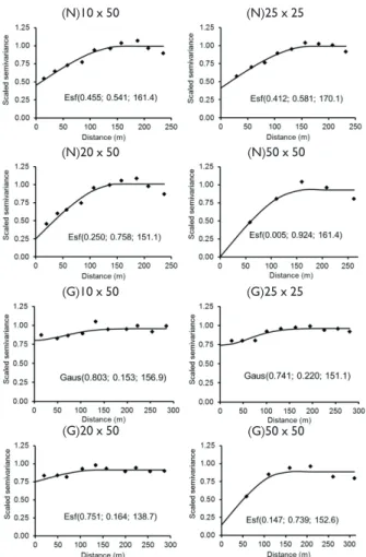
values (R²) were higher for the number of trees in the 10 x 50 m, 20 x 50 m and 25 x 25 m sample units, and lower values (0.55) for the basal area in rectangular sample units (Table 2), while the weighted sum of squared deviations (WSSD) presented higher values for the 50 x 50 m sample unit, when both variables were under analysis. Therefore, the shape and size of sample units tend to change the way the spatial structure is detected by the geostatistical analysis.
Next, in the cross validation (Table 3), the predominance of fits with spherical model was observed
in all sample unit sizes for number of trees, with lower values of weighted sum of squared deviations (WSSD)
were obtained. This shows that the sampling grid was
efficient to detect the spatial characteristics of this
variable. In addition, for the basal area, the Gaussian model was choiced for 10 x 50 m and 25 x 25 m sample
units, while the spherical model was the most efficient
for 20 x 50 m and 50 x 50 m samples.
The semivariogram analysis for the number of trees presented spatial structure for all sample unit shapes under study, along with reduced dispersion of the observed values, close to the estimated average line
(Figure 1). Anisotropy was verified and this characteristic was confirmed along the distances, due to the directional
semivariograms structural similarity.
TABLE 1 Number of trees (N) and basal area (G) descriptive
statistics regarding different sizes and shapes or sample units in part of a mixed ombrophilous forest.
TABELA 1Estatística descritiva do número de árvores (N)
e área basal (G) para os diferentes tamanhos e formatos de unidades de amostra em um fragmento de Floresta Ombrófila Mista.
Size (m x m) N(n.ha-1)
Grubbs
test Min Avg Max SD CV Asym
KS test
N (n.ha-1)
10x50 3.887*1 180.0 563.9 980.0 161.0 28.5 0.150 0.043*
25x25 3.074NS 96.0 565.2 1,056.0 159.7 28.3 0.160 0.045*
20x50 3.702*1 230.0 565.0 920.0 137.5 24.3 0.037 0.029NS
50x50 2.831NS 296.0 562.7 904.0 120.6 21.4 -0.005 0.079NS
G (m².ha-1)
10x50 4.615*2 8.8 30.4 63.4 9.8 32.4 0.406 0.050*
25x25 4.271*1 7.4 30.5 59.5 8.9 29.1 0.281 0.037NS
20x50 3.498NS 11.8 30.7 57.5 7.7 25.0 0.308 0.043NS
50x50 3.133NS 13.4 30.6 43.3 5.5 18.0 -0.332 0.058NS Where: Min = Minimum; Avg = average; Max = Maximum; SD = Standard deviation; CV = coefficient of variation; Asym = Asymmetry; KS test = Kolmogorov-Smirnov test; NS = non significant (Grubbs Test = there are no outlier values in the data series; and KS Test = data with normal distribution); * = significant at 5% error probability and 1,2= number of outlier removed.
TABLE 2 Fitted semivariogram parameters for the number
of trees per hectare (N) and basal area per hectare (G) as a function of different sample unit sizes for part of a mixed ombrophilous forest.
TABELA 2 Parâmetros dos semivariogramas ajustados para o
número de árvores por hectare (N) e Área Basal por hectare (G) em função de diferentes tamanhos de unidades de amostra para o fragmento de Floresta Ombrófila Mista.
Variable S.U.
(m x m) Model Co C R (m) DD
(%) R² WDSS
N (n.ha-1)
10 x 50
Spherical 0.455 0.541 161.6 45.7 0.911 0.0018 Exponential0.342 0.684 183.0 33.3 0.867 0.0029 Gaussian 0.537 0.461 138.0 53.8 0.904 0.0019
25 x 25
Spherical 0.412 0.581 170.1 41.5 0.946 0.0013 Exponential 0.241 0.782 181.5 23.5 0.903 0.0022 Gaussian 0.514 0.482 148.3 51.6 0.938 0.0015
20 x 50
Spherical 0.250 0.758 151.1 24.8 0.899 0.0027 Exponential 0.250 0.808 202.3 23.6 0.862 0.0049 Gaussian 0.494 0.542 164.0 47.7 0.882 0.0038
50 x 50
Spherical 0.005 0.924 161.4 0.5 0.845 0.0061
Exponential 0.002 0.918 158.0 0.2 0.668 0.0124 Gaussian 0.084 0.876 154.3 8.7 0.751 0.0097
G (m².ha-1)
10 x 50
Spherical 0.769 0.185 170.8 80.6 0.443 0.0015 Exponential0.723 0.232 165.2 75.7 0.311 0.0018 Gaussian 0.803 0.153 156.9 84.0 0.492 0.0014
25 x 25
Spherical 0.692 0.267 152.6 72.1 0.792 0.0009
Exponential0.602 0.363 165.2 62.4 0.712 0.0011 Gaussian 0.741 0.22 151.1 77.1 0.822 0.0008
20 x 50
Spherical 0.751 0.164 138.7 82.0 0.528 0.0009 Exponential0.745 0.175 165.2 81.0 0.446 0.0012 Gaussian 0.785 0.132 124.4 85.6 0.533 0.0010
50 x 50
Spherical 0.147 0.739 152.6 16.6 0.794 0.0038 Exponential 0.025 0.867 152.7 2.8 0.673 0.0060
Gaussian 0.401 0.493 156.9 44.9 0.731 0.0049
The variable basal area presented low spatial correlation between the points sampled in the smaller area units, revealing variation that was close to the pure nugget effect model, with a low degree of spatial dependence in the rectangular sample units, when compared to the square sample units. However, all the sampling scales tested can use geostatistics to carry out basal area estimates.
DISCUSSION
The change in size and shape of sample units altered the data frequency distribution, in which the increase in area tended to decrease the asymmetry and to reduce the presence of extreme values, with a tendency to the normal distribution of the data. Similar behavior was observed by Oda-Souza et al. (2010) in four forest formations in São Paulo state, Brazil, and by Bellehumeur
et al. (1997) when they evaluated the density of species
in a Malasian tropical forest.
With the semivariogram analysis it was possible to observe that the spatial continuity structure of the
variable number of trees was more significant, when it
compared with basal area (Figure 1). These results were
confirmed by the values of spatial dependence degree.
For example, the sample units measuring 10 m x 50 m and 20 m x 50 m show strong spatial dependence on the number of trees, and at the same time reveal weak spatial dependence on the basal area.
The basal area low spatial dependence might be explained in the spatial distributions of diameter classes in native forests. A random spatial behavior with increase in the size of trees has been shown in many types of forests
(PICARD et al., 2010; ZENNER; PECK, 2009), where
smaller trees exhibited a grouped spatial distribution, while larger trees tended to a random spatial distribution which, despite the low density, represented a large wood stock.
Results contrary to the spatial dependence for the number of trees were observed by Akhavan et al.
(2010), with pure nugget effect using 300 m² and 700 m²
concentric circular sample units located in the Caspian forests native, northern of Iran. These authors observed moderate spatial dependence for the basal area and volume in circular sample units distributed in a two-stage systematic process, however, the values obtained in the cross validation were not satisfactory and, therefore, kriging was not recommended as an alternative to estimate the wood stock in forests.
The sample unit shapes for number o tress with different areas revealed that both sizes can be used for
geostatistics analysis. According to Levin (1992) there is not
TABLE 3 Parameters of the cross validation of fitted
semivariograms selected for the number of trees per hectare (N) and basal area per hectare (G) in each sample unit shape in a portion of mixed ombrophilous forest.
TABELA 3 Parâmetros da validação cruzada dos ajustes
geoestatísticos selecionados para o número de árvores por hectare (N) e área basal por hectare (G) em cada formato de unidade de amostra para um fragmento de Floresta Ombrófila Mista.
Variable S.U. (m x m)
Model Selected
Coefficient
R²vc Syx % Linear Angular
N (n.ha-1)
10 x 50 Spherical 12.48 0.98 0.398 22.2 25 x 25 Spherical -5.99 1.01 0.422 21.4 20 x 50 Spherical -2.549 1.00 0.461 17.8 50 x 50 Spherical -16.77 1.03 0.621 13.1
G (m².a-1)
10 x 50 Gaussian 7.32 0.78 0.118 29.9 25 x 25 Gaussian 6.64 0.80 0.138 27.2 20 x 50 Spherical 4.90 0.85 0.107 20.0 50 x 50 Spherical 3.95 0.87 0.321 13.8
Where: R²vc = cross validation coefficient of determination; and Syx% =
standard errors of estimate (%).
(N)10 x 50 (N)25 x 25
(N)20 x 50 (N)50 x 50
(G)10 x 50 (G)25 x 25
(G)20 x 50 (G)50 x 50
FIGURE 1 Fitted theoretical semivariograms for the number of
trees (N) and basal area (G) per hectare in different sample units in a portion of a mixed ombrophilous forest.
FIGURA 1 Semivariogramas teóricos ajustados para o
AND SHAPE OF SAMPLE UNITS
an unique scale for population estimation, which justifies
the use of different combinations of shape and sizes. Regarding the basal area spatial continuity, the square sample units seemed to be the most suitable, mainly for capturing smaller variability inside the sample.
Kerry and Oliver (2007) mentioned that reliable results in determining management specific areas can be obtained
from small sample units which are spatially dependent. Rectangular sample units for basal area presented a spatial pattern tending to pure nugget effect. According to
Robles (1978), with rectangular sample units it is possible
to capture higher variability and, therefore, make them more heterogeneous and the smaller difference between samples is reached along the gradient. However, this
does not influence negatively the correlation between
sample units and the similarity between distances, which are preconditions of the geostatistics methods.
The basal area behavior observed in the rectangular sample units might be related to the diversity found in native forests, mainly due to the high diameter variability, besides the presence of clearings and bamboo in some points. Despite the rectangular shape being recommended for native species forest inventories,
Fortin (1999) does not recommend its use to detect
the spatial continuity structure, since the magnitude of spatial autocorrelation would be biased according to its orientation to the population spatial pattern.
Oda-Souza et al. (2010) evaluated 5 x 5 m, 10 x 10 m and 20 x 20 m square sample units and 10 x 20 m,
10 x 30 m, 10 x 40 m, 10 x 50 m and 5 x 80 m rectangular
sample units in the spatial dependence structure of four forest formations in São Paulo state, Brazil. These authors
concluded that there is influence of the size and shape of
the plots in the detection of spatial continuity, in which the 10 x 40 m rectangular shaped units made it possible to capture the variability of the formations, while the 20 x 20 m sample units were proved the best to describe the spatial structure.
By analyzing Moran’s I spatial autocorrelation
coefficient, which indicated the spatial association degree
present in the data set, as a function of size and shape of
the sample units of three forest species, Fortin (1990)
concluded that the general form of the correlograms remained consistent. However, the magnitude of autocorrelation varied with increase in the 10 x 20 m, 20 x 10 m and 15 x 15 m sample unit sizes, while decreasing in 20 x 20 m plots, since larger areas represented larger variation sources, which resulted in lower spatial autocorrelation.
The spatial continuity for the number of trees and basal area increased with the increase in the square
sample unit size. Due to the sample grid configuration,
with predominance of one-direction points (East-West), the semivariograms presented small number of values observed to consider the 50 x 50 m sample units as the most suitable. In this sense, Oda-Souza et al. (2010) observed that the spatial dependence of the variable biomass was
intensified with the increase in square sample units which
was not seen in rectangular sample units.
The practical range (A), which determined the distance from which the variable does not have relevant
influence on its neighbor (YAMAMOTO; LANDIM, 2013), was slightly higher for the number of trees when
compared to the basal area, where the sample unit size
did not influence the range directly. Since the results
evidenced the presence of correlation between the sample units, the number of units to be sampled must consider the range variable. Therefore, for inventories carried out aiming at quantifying basal area, the positioning of sample units with a minimum interval of 150 m is recommended, so that the spatial component is incorporated to the forest survey process. However, if the distance is larger than that, the sample units can be treated in a statistically independent way (VIERA, 2000).
CONCLUSION
The increase in the square sample unit sizes improved the spatial continuity for the number of trees and basal area while not changing the rectangular plots semivariogram behavior. The rectangular plots are only recommended for detection of the spatial continuity of number of trees.
Due to the semivariogram similarity, it was seen that it is not possible to determine an optimal sample unit size for the variable number of trees, whose sampling
definition should consider the best positioning in the field, in which small sample units lead to high variability.
For studies that aim at detecting the spatial continuity structure for the variable basal area, square sample units are the most suitable.
REFERENCES
AKHAVAN, R.; AMIRI, Z.; ZOBEIRI, M. Spatial variability of forest growing stockusing geostatistics in the Caspian region of Iran. Caspian Journal of Environmental Sciences, v. 8, n. 1, p. 43-53, 2010.
AKHAVAN, R.; KIA-DALIRI, H.; ETEMAD, V. Geostatistically estimation and mapping of forest stock in a natural unmanaged forest in the Caspian region of Iran. Caspian
Journal of Environmental Sciences, v. 13, n. 1, p.
ALVARES, C. A.; STAPE, J. L.; SENTELHAS, P. C.; GONÇALVES, J. L. M.; SPAROVEK, G. Koppen’s climate classification map for Brazil. Meteorologische Zeitschrift, v. 22, n. 6, p.
711-728, 2014.
AMARAL, L. P.; FERREIRA, R. A.; LISBOA, G. S.; LONGHI, S. J.; WATZLAWICK, L. F. Variabilidade espacial do índice de diversidade de Shannon-Wiener em Floresta Ombrófila Mista. Scientia Forestalis, v. 41, n. 97, p. 83-93, 2013.
BELLEHUMEUR, C.; LEGENDRE, P. Multiscale sources of variation in ecological variables: modeling spatial dispersion, elaborating sampling designs. Landscape Ecology,v. 13, p. 15-25, 1998.
BELLEHUMEUR, C.; LEGENDRE, P.; MARCOTTE, D. Variance and spatial scales in a tropical rain forest: changing the size of sampling units. Plant Ecology, v. 130, p. 89-98, 1997.
BRITO, C. R.; CARDOSO, C. R.; SANTOS, A. S.; SANTOS, G. R.; MEDEIROS, N. G. Geoestatística aplicada na geração de modelos numéricos de elevação. Geografia Ensino e
Pesquisa, v. 17, n. 3, p. 143-152, 2013.
CAMBARDELLA, C. A.; MOORMAN, T. B.; NOVAK, J. M.; PARKIN, T. B.; KARLEN, D. L.; TURCO, R. F.; KONOPKA, A. E. Field-scale variability of soil properties in central Iowa soils. Soil Science Society of America Journal, v. 58, n.
5, p. 1501-1511, 1994.
CARVALHO, J. R. P.; VIEIRA, S. R.; GREGO, C. Comparação de métodos para ajuste de modelos de semivariograma da precipitação pluvial anual. Revista Brasileira de
Engenharia Agrícola e Ambiental, Campina Grande, v.
13, n. 4, p. 443-448, 2009.
CORTE, A. P. D.; SANQUETTA, C. R.; FIGUEIREDO FILHO, A.; PEREIRA, T. P.; BEHLINH, A. Desempenho de métodos e processos de amostragem para avaliação de diversidade em Floresta Ombrófila Mista. Floresta, v. 43, n. 4, p.
579-582, 2013.
FERREIRA, I. O.; SANTOS, G. R. dos; RODRIGUES, D. D. Estudo sobre a utilização adequada da krigagem na representação computacional de superfícies batimétricas.
Revista Brasileira de Cartografia, v. 65, n. 5, p. 831-842, 2013.
FIGUEIREDO FILHO, A.; DIAS, A. N.; STEPKA, T. F.; SAWCZUK, A. R. Crescimento, mortalidade, ingresso e distribuição diamétrica em Floresta Ombrófila Mista.
Revista Floresta, v. 40, n. 4, p. 763-776, 2010.
FISHER, R. A. Statistical methods and scientific inference. Oliver & Boyd, 1956. 175 p.
FORTIN, M. J. Effects of sampling unit resolution on the estimation of spatial autocorrelation. Ecoscience, v. 6, p.
636-641, 1999.
FOX, J. C.; BIC, H.; ADES, P. K. Spatial dependence and individual-tree growth models. Forest Ecology and
Management, Amsterdam, v. 245, p. 10-19, 2007.
GOMES, N. M.; SILVA, A. M.; MELLO, C. R.; FARIA, M. A.; OLIVEIRA, P. M. Métodos de ajuste e modelos de semivariograma aplicados ao estudo da variabilidade espacial de atributos físico-hídricos do solo. Revista
Brasileira Ciência do Solo, Viçosa, v. 31, n. 3, p.
435-443, 2007.
GOTWAY, C. A.; YOUNG, L. J. Combining incompatible spatial data. Journal of the American Statistical Association, v. 97, p. 632-648, 2002.
ISAAKS, E. H.; SRIVASTAVA, R. M. Applied geoestatistics:
an introduction to. Oxford: Oxford University Press, 1989. 561 p.
KANEGAE JÚNIOR, H.; MELLO, J. M.; SCOLFORO, J. R. S.; OLIVEIRA, A. D. Avaliação da continuidade espacial de características dendrométricas em diferentes idades de povoamentos clonais de Eucalyptussp. Revista Árvore, Viçosa, v. 31, n. 5, p. 859-866, 2007.
KANEGAE JÚNIOR, H.; SCOLFORO, J. R. S.; MELLO, J. M.; OLIVEIRA, A. D. Avaliação de interpoladores estatísticos e determinísticos como instrumento de estratificação de povoamentos clonais de Eucalyptussp. Cerne, Lavras, v. 12, n. 2, p. 123-136, 2006.
KERRY, R.; OLIVER, M. A. Comparing sampling needs for variograms of soil properties computed by the method of moments and residual maximum likelihood. Geoderma, v. 140, p. 383-396, 2007.
LANDIM, P. M. B. GEOEAS: introdução à análise geoestatística.
Rio Claro: UNESP/IGCE, 2003. 42 p.
LEVIN, S. A. The problem of pattern and scales in ecology.
Ecology, Durham, v. 73, p. 1943-1967, 1992.
MACHADO, S. A.; FIGUEIREDO FILHO, A. Dendrometria. UNICENTRO, 2006. 316 p.
MELLO, J. M.; DINIZ, F. S.; OLIVEIRA, A. D.; SCOLFORO, J. R. S.; ACERBI JÚNIOR, F. W.; THIERSCH, C. R. Métodos de amostragem e geoestatística para estimativa do número de fustes e volume em plantios de Eucalyptus grandis.
Floresta, v. 39, n. 1, p. 157-166, 2009.
ODA-SOUZA, M.; BATISTA, J. L. F.; RIBEIRO JÚNIOR, P. J.; RODRIGUES, R. R. Influência do tamanho e forma da unidade amostral sobre a estrutura de dependência espacial em quatro formações florestais do estado de São Paulo. Floresta, v. 40, n. 4, p. 849-860, 2010.
PELISSARI, A. L.; FIGUEIREDO FILHO, A.; CALDEIRA, S. F.; MACHADO, S. do A. Geoestatística aplicada ao manejo de povoamentos florestais de teca, em períodos pré-desbaste seletivo, no estado do Mato Grosso. Revista Brasileira de
AND SHAPE OF SAMPLE UNITS
PICARD, N.; MAGNUSSEN, S.; BANAK, L. N.; NAMKOSSERENE, S.; YALIBANDA, Y. Permanent sample plots for natural tropical forests: a rationale with special emphasis on Central Africa. Enviromental Monitoring
Assessment, v. 164, p. 279-295, 2010.
ROBERTSON, G. P. GS+: geostatistics for the environmental sciences. Gamma Design Software, 2008.179 p.
ROBLES, C. Estadística. Facultad de Ciências Forestales, Universidad Nacional de Santiago del Estero, 1978. 285 p.
UBIALLI, J. A.; FIGUEIREDO FILHO, A.; MACHADO, S. A.; ARCE, J. E. Comparação de métodos e processos de amostragem para estudos fitossociológicos em uma floresta ecotonal na região norte mato-grossense. Floresta, v. 39,
n. 3, p. 511-523, 2009.
VIEIRA, S. R. Geoestatísticaem estudos de variabilidade espacial do solo. In: NOVAES, R. F.; ALVAREZ, V. H.; SCHAEFER, C. E. G. R. (Ed.). Tópicos em ciência do solo. Viçosa, MG: Sociedade Brasileira de Ciência do Solo, 2000. p. 2-54.
VIEIRA, S. R.; NIELSEN, D. R.; BIGGAR, J. W.; TILLOTSON, P. M. The scaling of semivariograms and the kriging estimation of field-measured properties. Revista
Brasileira de Ciência do Solo, Viçosa, v. 21, p.
525-533, 1997.
YAMAMOTO, J. K.; LANDIM, P. M. B. Geoestatística:
conceitos e aplicações. Oficina de Textos, 2013. 215 p.
ZENNER, E. K.; PECK, J. E. Characterizing structural conditions in mature managed red pine: spatial dependency of metrics and adequacy of plot size. Forest Ecology and