JARBAS NUNES VIDAL FILHO
CIDADÃO COMO UM SENSOR HUMANO VOLUNTÁRIO EM UMA SOCIEDADE HABILITADA ESPACIALMENTE: UM ESTUDO DE CASO
COM INFORMAÇÃO GEOGRÁFICA VOLUNTÁRIA NA ÁREA DE SEGURANÇA PÚBLICA
Dissertação apresentada à Universidade Federal de Viçosa, como parte das exigências do Programa de Pós-Graduação em Ciência da Computação, para obtenção do título de Magister Scientiae.
VIÇOSA
Ficha catalográfica preparada pela Seção de Catalogação e Classificação da Biblioteca Central da UFV
T
Vidal Filho, Jarbas Nunes, 1986-
V648c Cidadão como um sensor humano voluntário em uma 2013 sociedade habilitada espacialmente: um estudo de caso com
informação geográfica voluntária na área de segurança pública / Jarbas Nunes Vidal Filho. – Viçosa, MG, 2013.
xiv, 107f. : il. ; 29cm.
Inclui apêndice.
Orientador: Jugurta Lisboa Filho
Dissertação (mestrado) - Universidade Federal de Viçosa. Referências bibliográficas: f. 102-107
1. Web 2.0. 2. Sistemas de computação interativos. 3. Sistemas de informação geográfica. 4. Estatística. 5. Segurança pública. I. Universidade Federal de Viçosa.
Departamento de Informática. Programa de Pós-Graduação em Ciência da Computação. II. Título.
ii
iii
AGRADECIMENTOS
Em primeiro lugar, gostaria de agradecer a Deus por tudo que tenho alcançado até hoje. Agradeço pelas oportunidades concedidas, pela força de vontade de vencer na vida, por sempre colocar pessoas boas no meu caminho e por sempre escutar minhas preces. Diversas pessoas fazem parte desta grande conquista, cada amigo ou colega sabe a sua verdadeira contribuição nesses quase dois anos que estive em Viçosa. Peço desculpas, se por acaso não se lembrar de citar alguns nomes que estiveram presentes nesses últimos anos.
Não posso deixar de agradecer especialmente à minha mãe Teresinha, esta foi peça fundamental, uma verdadeira heroína para que eu pudesse chegar ao fim do ensino médio, graduação e agora mestrado. Sempre se dedicou ao máximo aos seus três filhos, nunca deixou faltar nada, principalmente quando o assunto era educação, formação pessoal e profissional. Não tenho dúvidas que se não fosse ela, eu não chegaria aqui, pois foi sempre ela quem me ajudou, sempre cuidou para que as coisas dessem certo. Obrigado mãe, mais uma etapa está sendo vencida. Agora, é batalhar pelo doutorado, se Deus permitir, a senhora terá um filho com título de doutor.
Agradeço também ao meu orientador Jugurta Lisboa Filho, este abriu minha mente e me fez entender mais sobre a pesquisa científica, ajudou a desenvolver bons trabalhos na escrita e nas ideias. Além disso, foi essencial para que eu pudesse vir para Viçosa, pois conseguiu com a empresa Sydle uma bolsa de mestrado e me recebeu como seu orientando. Obrigado Jugurta, agradeço seu companheirismo, amizade e as conversas que sempre me animavam para continuar o mestrado.
Quero registrar meus agradecimentos à empresa Sydle pela bolsa de estudos e ao Victor da empresa Sydle, este me ligou e me garantiu a bolsa de estudos. Agradeço ao meu coorientador Gerson pelas contribuições no meu trabalho. Agradeço também ao Fernando do CIOSP-Mossoró pela amizade, esforço e apoio para execução deste projeto e ao CIOSP pela liberação dos dados oficiais.
iv
de pesquisa. Registro meus votos de agradecimento ao aluno de Ciência da Computação da UFV, Diogo Franklin, pela colaboração no projeto.
Agradeço aos meus colegas de curso que sempre me ajudaram. Em especial ao Vitor Ramalho e Denilson Silva no qual vou carregar a amizade sempre, com eles foi possível esquecer um pouco a saudade de casa e o estresse do mestrado. Afinal, sempre que era possível, tomávamos aquela cervejinha e colocávamos as conversas em dia.
Quero agradecer ao meu irmão Fabrício Luiz pela sua contribuição nesses anos que tive em Viçosa. Gostaria de agradecer ao meu irmão André Luís (in memorian), pois sei que ele sempre estará guiando meus passos. Agradeço ao meu tio Jânio por ter colaborado na minha formação nos dois anos que morei com ele. E registro meus agradecimentos a Thalita Rimes, pela paciência e companheirismo.
Tenho que registrar meus agradecimentos a minha ex-orientadora Angélica por ter dado oportunidade de ser bolsista de Iniciação Científica por três anos consecutivos, e assim, permitiu que eu pudesse conhecer o mundo GEO. Foi a partir do primeiro ano de Iniciação Científica que descobri a afinidade com a pesquisa, daí então, trabalhamos no desenvolvimento de artigos científicos. Angélica sempre foi e continuará uma grande amiga. Obrigado Angélica, por você tenho enorme carinho e admiração.
Agradeço aos professores do mestrado pela contribuição na minha formação durante as disciplinas do mestrado. Jamais irei esquecer-me das aulas do professor Zé Luis, ele nos ensinava a pensar “fora da caixa”. Agradeço ao Natan, Tiago e Mário, estes foram companheiros de apartamento em Viçosa. Obrigado pela convivência respeitosa de vocês.
Devo agradecer também ao CNPQ/MCT por financiar minha pesquisa nos últimos meses de mestrado com uma bolsa DTI-3. E ao Departamento de Informática da UFV por ceder suas instalações para que eu pudesse desenvolver meus trabalhos. Agradeço também aos funcionários deste departamento, pois sempre me trataram super bem.
Deixo meus agradecimentos ao Altino, secretário do programa de pós-graduação em computação. Agradeço ao amigo Júlio de BH pela ajuda ao chegar a Minas Gerais.
v
sempre que era possível me ligavam ou procuravam saber como estava a vida em Viçosa.
A todos que contribuíram com esta conquista e torceram pelo meu sucesso, agradeço do fundo do meu coração. Nós somos vencedores!
vi BIOGRAFIA
JARBAS NUNES VIDAL FILHO é filho de Jarbas Nunes Vidal e Teresinha Chaves e Silva Vidal, brasileiro, nascido em 31 de Julho de 1986, na cidade de Limoeiro do Norte, no estado do Ceará.
No ano de 2005, concluiu o ensino médio na Escola Normal Rural de Limoeiro do Norte. Iniciou no ano de 2007, na Universidade Federal Rural do Semi-Árido (UFERSA), o curso superior em Ciência da Computação, através do qual se tornou Bacharel no ano de 2011.
vii SUMÁRIO
1
LISTA DE FIGURAS ... viii
LISTA DE TABELAS ... x
RESUMO ... xi
ABSTRACT ... xiii
1 INTRODUÇÃO ... 1
1.1. O problema e sua importância ... 1
1.2. Hipótese ... 3
1.3. Objetivos... 3
1.4. Organização da dissertação ... 4
2 ARTIGOS ... 7
2.1. Artigo I: Starting a Spatially Enabled Society: a web system for collecting volunteered geographic information in the area of public security ... 8
2.2. Artigo II: Qualitative Analysis of Volunteered Geographic Information in a Spatially Enabled Society Project ... 19
2.3. Artigo III: Cidadão como um Sensor Humano Voluntário em um Projeto de Sociedade Habilitada Espacialmente: uma análise qualitativa da informação geográfica voluntária na área de segurança pública ... 40
3 CONCLUSÕES GERAIS E TRABALHOS FUTUROS ... 80
APÊNDICE A ... 82
Artigo IV: Análise de Dados de Ocorrências Policiais Utilizando Tecnologia da Geoinformação ... 82
APÊNDICE B ... 87
Artigo V: Informação Geográfica Voluntária no Pantanal: um sistema web colaborativo utilizando a API google maps ... 87
APÊNDICE C ... 99
Artigo VI: Process for the extraction and documentation of the metadata in the MGB profile using free software ... 99
APÊNDICE D ... 100
Artigo VII: Extração e Documentação de Metadados no Perfil MGB Utilizando Software Livre ... 100
viii
LISTA DE FIGURAS
Artigo I
Figure 1 – Interface of the system ... 14
Figure 2 - Statistical analysis by category and user ... 15
Figure 3 - Risk analysis based on Kernel Map ... 16
Figure 4 - Infowindow of collaboration module ... 17
Artigo II Figure 1 - Interface of the system MossoróCrimes ... 23
Figure 2 - Module of Collaboration ... 25
Figure 3 - Service of grade for evaluation the collaboration ... 27
Figure 4 - Forum of the collaboration ... 28
Figure 5 - Comparing the number of record in databases MossoróCrimes and CIOSP . 35 Figure 6 - Comparing the number of record in databases MossoróCrimes and CIOSP . 36 Figure 7 - Gain of Information in Security Category for CIOSP ... 37
Artigo III Figura 1 - Interface do sistema MossoróCrimes ... 46
Figura 2 - Módulo de Colaboração ... 47
Figura 3 - Utilização do serviço de análise de risco... 48
Figura 4 - Serviço de “News” ... 48
Figura 5 - Serviço de nota para avaliação da colaboração ... 51
Figura 6 - Fórum da colaboração ... 52
Figura 7 - Ganho de informações para o CIOSP pelas categorias do MossoróCrimes . 60 Figura 8 - Comparando o número de registro referente a quatro tipos de ocorrências nas bases de dados do MossoróCrimes e CIOSP ... 60
Figura 9 - Comparando o número de registro referente a cinco tipos de ocorrências nas bases de dados do MossoróCrimes e CIOSP ... 61
Figura 10 - Ganho de informações na categoria segurança para o CIOSP ... 62
ix
no modo de visualização “passos iguais” para representar o índice de Moran global para as quatro variáveis definidas na base oficial do CIOSP (b) ... 67 Figura 13 - Índice de Moran Local para as quatro variáveis definidas no sistema MossoróCrimes (a). Índice de Moran Local para as quatro variáveis definidas na base oficial do CIOSP (b) ... 70 Figura 14 - Mapas no modo visualização “valor único” para representar o BoxMap para as quatro variáveis definidas no sistema MossoróCrimes (a). Mapas no modo visualização “valor único” para representar BoxMap para as quatro variáveis definidas na base oficial do CIOSP (b) ... 72 Figura 15 - Mapas no modo de visualização “Quantil” para as quatro variáveis definidas no sistema MossoróCrimes (a). Mapas da média móvel local para as quatro variáveis definidas no sistema MossoróCrimes (b) ... 75 Figura 16 - Mapas no modo de visualização “Quantil” para as quatro variáveis definidas na base oficial do CIOSP (a). Mapas da média móvel local para as quatro variáveis definidas na base oficial do CIOSP (b) ... 76 Apêndice A
Figura 1 - (a) Visualização em destaque indicando os bairros com maiores índices de ocorrências diversas; (b) Mapa de Kernel mostrando a incidência por cores em relação aos pontos ... 84 Figura 2 - (a) Visualizando em destaque o mapa indicando os bairros com maiores índices de roubos; (b) Mapa de Kernel mostrando a incidência por cores em relação aos pontos ... 85 Figura 3 - (a) Mapa indicando os bairros com maiores índices de trotes; (b) Mapa de Kernel mostrando a incidência por cores em relação aos pontos... 85 Apêndice B
x
LISTA DE TABELAS
Artigo II
Table 1 - Percentage of record for each category ... 29
Table 2 - Percentage of record of each category during the first and second month ... 30
Table 3 - Statistical returns by type of collaboration in the category Security ... 31
Table 4 - Statistical returns by type of collaboration in the category Others ... 32
Artigo III Tabela 1 - Percentual de Registro por categoria ... 53
Tabela 2 - Percentual de registro de cada categoria durante o primeiro e segundo mês . 54 Tabela 3 - Levantamento estatístico por tipo de colaboração na categoria Segurança ... 55
xi RESUMO
VIDAL FILHO, Jarbas Nunes, M.Sc., Universidade Federal de Viçosa, maio de 2013. Cidadão como um sensor humano voluntário em uma sociedade habilitada espacialmente: um estudo de caso com informação geográfica voluntária na área de segurança pública. Orientador: Jugurta Lisboa Filho. Coorientador: Gerson Rodrigues dos Santos.
xii
xiii ABSTRACT
VIDAL FILHO, Jarbas Nunes, M.Sc., Universidade Federal de Viçosa, may 2013. Citizen as a voluntary human sensor in a spatially enabled society: Qualitative Analysis of Volunteered Geographic Information in the area of public security. Adviser: Jugurta Lisboa Filho. Co-adviser: Gerson Rodrigues dos Santos.
xiv
1
1
INTRODUÇÃO
1.1. O problema e sua importância
As cidades brasileiras passam ou já passaram em um passado recente por grandes dificuldades no setor de segurança pública. A mídia brasileira relata todos os dias diversos casos de violência que estão disponíveis em vários meios de comunicação. O governo tem investido massivamente na área de segurança pública com a finalidade de reduzir cada vez mais a violência no país. No entanto, em algumas cidades brasileiras, como por exemplo, Mossoró, no estado do Rio Grande do Norte, os índices de violência aumentaram, principalmente o número de homicídios, o que tem gerado uma maior preocupação por parte da polícia e da população. A academia e os órgãos de segurança pública têm se unido no desenvolvimento de novas ferramentas e técnicas que venham apoiar as tomadas de decisão no setor de Segurança Pública, cujo objetivo é minimizar a criminalidade.
As Geotecnologias têm sido utilizadas por diversas organizações na área de segurança pública no combate à criminalidade, e estão se tornando cada vez mais fundamentais no processo de tomada de decisão. Órgãos de segurança pública têm aplicado ferramentas de geoprocessamento no dia a dia do seu trabalho e obtido bons resultados em ambientes de Sistema de Informação Geográfica (SIG). Os resultados alcançados pelos serviços de Geointeligência da polícia têm sido úteis para melhorar as atividades nos departamentos de polícia. No entanto, alguns departamentos possuem problemas que impedem o uso da informação espacial ou problemas que impedem tirar o proveito necessário quando se tem dados espaciais.
A partir disso, se torna necessário a utilização de Tecnologias da Informação (TI) para solucionar os possíveis problemas nesses departamentos, tornando eficaz o uso de informações espaciais, melhorando a partilha e o acesso aos dados. Alguns desses problemas estão listados abaixo (SENASP, 2013):
Muitos órgãos de polícia não possuem ou utilizam qualquer tipo de informação espacial;
2 Falta documentação sobre os dados; Faltam dados fornecidos pela população;
Não possui acesso à base de dados de outros órgãos, dados que poderiam ser combinados para auxiliar no combate à violência;
Entre outros.
Tornar uma sociedade habilitada espacialmente pode ser essencial para resolver os problemas listados anteriormente. Os usuários independem de plataforma computacional para fornecer ou consultar informações em tempo real sobre ocorrências nesse tipo de sociedade, além disso, a utilização de um sistema Web colaborativo atua como uma plataforma ligando pessoas aos dados. Os cidadãos podem compartilhar informação espacial de forma voluntária, denunciando pontos de vendas de drogas, roubos, furtos, entre outros tipos de ocorrências. Os dados fornecidos por cidadãos, que atuam como “sensores voluntários”, dão uma contribuição significativa para esses setores, o papel da VGI é fornecer informações de um determinado local de interesse do cidadão, onde muitas vezes os órgãos de polícia não têm conhecimento.
Os dados de VGI precisam de revisão para se tornar aceitável, sempre existe uma dependência dos especialistas do assunto para realizar essa validação, o que muitas vezes dificulta e atrasa uma tomada de decisão. Portanto, torna-se necessário repassar essa tarefa de revisão para os cidadãos voluntários, de forma que os mesmos poderão melhorar a qualidade dos dados. A utilização dos conceitos de Inteligência Coletiva em ambientes colaborativos se faz necessário, esse papel de revisão pode ser feito por cidadãos com ou sem nenhuma especialização. Segundo Goodchild (2007a) não existem serviços que venham apoiar a revisão de dados, a fim de corrigir erros e tornar a qualidade aceitável. VGI pode ser melhorada pelos próprios usuários, tornando os departamentos de polícia dependentes desse tipo de informação.
3
registradas pela polícia, departamento de trânsito local, guarda civil municipal e outros órgãos como, por exemplo, o Serviço de Atendimento Móvel de Urgência (SAMU), podem ser mais eficazes nos processos de tomada de decisão.
Através do sistema de VGI a polícia militar, guarda civil da cidade e outros órgãos podem tirar proveito dos dados de VGI para tornar uma ação bem mais eficiente, e o cidadão pode utilizar dessas informações para se prevenir da violência. Por exemplo, grandes cidades no Brasil são responsáveis por realizar grandes eventos em praça pública. Todos os anos os eventos registram ocorrências de acidente, homicídios, roubos, entre outros. A polícia poderia combinar dados de diferentes órgãos, por exemplo, acidente de trânsito, brigas de gangues, local de maior incidência de violência, dados de VGI, entre outros e melhorar a distribuição de viaturas e policiais aos redores do evento para reduzir a violência.
1.2. Hipótese
O uso de Informação Geográfica Voluntária (VGI) combinada com ferramentas da Web 2.0, na área de Segurança Pública, tanto pode contribuir no processo de tomada de decisão pelos gestores como servir de apoio ao cidadão.
1.3. Objetivos
O objetivo deste projeto é pesquisar meios de integrar ferramentas da Web 2.0 com mecanismos de suporte à VGI, visando contribuir para uma Sociedade Habilitada Espacialmente no âmbito de Segurança Pública. A ideia é que neste tipo de sociedade o cidadão irá atuar como um “sensor humano voluntário” no combate à violência, fornecendo e utilizando informação espacial disponíveis em tempo real.
Especificamente, pretende-se:
a) Pesquisar recursos da Web para desenvolver serviços que apoiem a VGI; b) Projetar e implementar serviços para VGI;
c) Projetar e implementar serviços para revisão de VGI utilizando os conceitos de Inteligência Coletiva e atribuição de notas;
4
e) Desenvolver como estudo de caso, um protótipo de um sistema Web Colaborativo para a cidade de Mossoró;
f) Avaliar o ganho de informações e a interação dos usuários com o sistema desenvolvido, e;
g) Comparar os dados do sistema desenvolvido com os dados oficiais da polícia de militar de Mossoró utilizando técnicas da estatística convencional e espacial.
1.4. Organização da dissertação
Esta dissertação foi elaborada de acordo com um dos formatos recomendados pela Comissão Coordenadora do Programa de Pós-Graduação em Ciência da Computação da UFV. A dissertação está organizada como uma coletânea de artigos produzidos durante o curso de mestrado. Ao todo são sete artigos, sendo três artigos resultantes desta pesquisa, mais dois artigos (Apêndice A e B) que não fazem parte do escopo principal da dissertação, entretanto, possuem temas referentes à pesquisa desenvolvida, e mais dois artigos (Apêndice C e D) que foram elaborados durante uma disciplina cursada no mestrado, porém, apenas o título, a lista de autores e o resumo estão sendo apresentados. Dentre os sete artigos, três já foram publicados, um foi aceito para publicação em uma conferência internacional (ICCSA`2013), um está submetido a uma conferência latino-americana (CLEI`2013), um foi submetido a uma revista (RESI) e outro será submetido a um periódico internacional (IJGIS).
A dissertação está organizada da seguinte forma:
5
No Capítulo 3 são apresentadas as conclusões gerais, relatando os resultados obtidos e os avanços alcançados. Além disso, são apresentadas algumas oportunidades de pesquisa que podem proporcionar trabalhos futuros para avançar os conhecimentos gerados nesta dissertação.
O Apêndice A contém um artigo que foi iniciado ainda durante a Iniciação Científica na graduação, porém concluído durante o mestrado. Este artigo serviu como motivação para o desenvolvimento desta dissertação na área de segurança pública.
O Apêndice B apresenta um artigo elaborado durante a disciplina de ENF612-Sistemas de Informação Geográfica, cursada no mestrado. Nesse artigo é descrito um sistema de VGI para a região do Pantanal, esta iniciativa surgiu a partir da necessidade de escrever um artigo para a disciplina, portanto, uniu-se o tema de pesquisa no mestrado com o evento Geopantanal que se encontrava aberto para submissão.
O Apêndice C mostra o título, lista de autores e o resumo de um artigo que foi elaborado na disciplina INF624-Banco de Dados Espaciais, cursada no mestrado. Nesse artigo é proposto um processo para extração de metadados utilizando software livre. O objetivo é facilitar a documentação dos dados por parte dos produtores de dados espaciais e daqueles que disponibilizam dados utilizando a Infraestrutura de Dados Espaciais GeoMINAS.
O Apêndice D apresenta uma versão estendida do artigo do Apêndice C. Esta versão oferece uma metodologia utilizando templates do GeoNetwork para facilitar a documentação do dados espaciais.
A seguir estão relacionadas as referências completas dos artigos que compõem esta dissertação:
Capítulo 2:
VIDAL FILHO, J. N.; LISBOA-FILHO, J.; SOUZA, W. D.; OLIVEIRA, D. F. Starting a spatially enabled society: a web system for collecting volunteered geographic information in the area of public security. In The Fifth International Conference on Advanced Geographic Information Systems, Applications, and Services (GEOProcessing), 5, 2013, Nice, France. Proceedings... Nice: IARIA, 2013. p. 151-154.
6
its Applications (ICCSA), 13, 2013, Ho Chi Minh City, Vietnam. (Aceito para publicação).
VIDAL FILHO, J. N.; LISBOA-FILHO, J.; SANTOS, G. R.; SOUZA, W. D. Cidadão como um Sensor Humano Voluntário em um Projeto de Sociedade Habilitada Espacialmente: uma análise qualitativa da informação geográfica voluntária na área de segurança pública. Artigo a ser submetido ao International Journal of Geographical Information Science, 2013.
Apêndice A:
VIDAL FILHO, J. N.; FARIAS, A. M. G.; CASTRO, A. F.; LISBOA-FILHO, J. Análise de Dados de Ocorrências Policiais Utilizando Tecnologia da Geoinformação In: Simpósio Regional de Geoprocessamento e Sensoriamento Remoto (GeoNordeste), 5, 2011, Feira de Santana, BA, Brasil. Anais... Feira de Santana: V Simpósio de Geoprocessamento e Sensoriamento Remoto e III Seminário de Geotecnologias, 2011, p. 108-111.
Apêndice B:
SOUZA, W. D.; VIDAL FILHO, J. N.; RIBEIRO, C. A. A. S.; LISBOA-FILHO, J.; FRANKLIN, D. Informação Geográfica Voluntária no Pantanal: um sistema Web colaborativo utilizando a API Google Maps. In: Simpósio de Geotecnologias do Pantanal (GeoPantanal), 4., 2012, Bonito, MS Anais... Bonito: Embrapa Informática Agropecuária/INPE, 2012. p.763-772.
Apêndice C:
SOUZA, W. D.; RIBEIRO, A. A. A.; NOGUEIRA, R. S.; VIDAL FILHO, J. N.; SANTOS, A. S.; SILVEIRA, J. A.; DUARTE, D. C. O.; LISBOA-FILHO, J. Process for the extraction and documentation of the metadata in the MGB profile using free software. Artigo submetido a Conferencia Latinoamericana en Informática (CLEI`2013).
Apêndice D:
7
2
ARTIGOS
Este capítulo apresenta uma coletânea contendo três artigos resultantes da pesquisa que deu origem a essa dissertação. Esses três artigos podem ser vistos como a base central desta dissertação. O primeiro artigo, intitulado “Starting a Spatially Enabled Society: a Web System for Collecting Volunteered Geographic Information in the Area of Public Security” apresenta a proposta inicial do projeto desenvolvido. Esse artigo foi publicado como trabalho em andamento e forneceu um bom feedback para prosseguirmos na pesquisa.
No segundo artigo, intitulado “Qualitative Analysis of Volunteered Geographic Information in a Spatially Enabled Society Project” são apresentadas as primeiras análises estatísticas referentes ao ganho de informação com a implantação do sistema de VGI e a interação do usuário com o sistema. Além disso, compara as bases do sistema de VGI com a base oficial da polícia militar, com objetivo de mostrar o ganho de informações do sistema de VGI para o Centro Integrado de Operações em Segurança Pública (CIOSP) de Mossoró/RN. Neste artigo também são apresentados dois mecanismos para aumentar a qualidade da VGI.
8
2.1. Artigo I: Starting a Spatially Enabled Society: a web system for collecting volunteered geographic information in the area of public security
Jarbas Nunes Vidal-Filho, Jugurta Lisboa-Filho, Wagner Dias de Souza e Diogo Franklin de Oliveira
In: THE FIFTH INTERNACIONAL CONFERENCE ON ADVANCED
GEOGRAPHIC INFORMATION SYSTEMS, APPLICATIONS, AND SERVICES (Geoprocessing), 5, 2013, Nice, France. Proceedings... Nice: IARIA, 2013. p. 151-154
RESUMO
Uma sociedade habilitada espacialmente fornece aos cidadãos, empresas e governo acesso aos dados geográficos independente de plataforma computacional. Este artigo descreve um sistema Web colaborativo utilizando a API do Google Maps para coletar informações geográficas sobre a área de Segurança Pública e disseminar em todos os níveis de uma sociedade utilizando ferramentas da Web 2.0. Os dados gerados pelo usuário se tornam mais uma fonte de dados para que órgãos envolvidos em Segurança Pública utilizem as informações para tentar minimizar a violência e que o cidadão possa se prevenir da criminalidade.
Palavras-chave: Informação Geográfica Voluntária, Systems Web, Google Maps, Segurança Pública.
ABSTRACT
A spatially enabled society provides to citizens, businesses and government access to spatial data regardless of computing platform. This paper describes a collaborative Web system to gather geographic information about the area of public security and disseminate it at all levels of a society using Web 2.0 tools. The data generated by the user become another source of data for agencies involved in public security to use the information in order to try to minimize violence and allow citizens to protect themselves from criminality.
Keywords: Volunteered Geographic Information, Web Systems, Google Maps, Public Security.
1 INTRODUCTION
9
organization, in which the factor "where" is important and precedent to perform an action on several sectors, such as public security, health, urban planning, deforestation control, agricultural production and others. The economic development, social stability, improvement of citizen’s public security, and others can be reached by developing products and services that are based on geographic information collected by all levels of a society or government (RAJABIFARD, 2008).
These actions can be facilitated by the development of a spatially enabled society (RAJABIFARD, 2008). In this type of society, spatial information is regarded as common goods made available to citizens and organizations to assist in developing techniques to support decision making (RAJABIFARD, 2008) and (MOHAMMDI et al., 2010). A spatially enabled society in the context of public security may be useful to bring citizens closer to police departments and improve the activities within these organizations. Any user may search for a service or information, which should always be available and reliable access (WILLIAMSON; RAJABIFARD; WALLACE, 2012). Moreover, people can voluntarily contribute information to help security departments to make decisions based on volunteered information.
For the development of such society, it is necessary the use spatial data. These, in turn, need to have a certain degree of quality, sufficiently reliable, easily accessible and available in real time for use by that society (RAJABIFARD, 2008). Based on this understanding, Spatial Data Infrastructures (SDI) are being developed in many countries as a platform that improves the sharing, access and integration of spatial data and services. An SDI can also store spatial data and provide services of access to data supplied voluntarily.
In recent years, the amount of spatial data generated by the users has grown. Increasingly users are indexing content based on their geographic coordinates. With this new paradigm of spatial data production, the term Volunteered Geographic Information (VGI) has arisen, identified by Goodchild (2007a) as a new phenomenon to describe user-generated information, combining elements of Neogeography, Collective Intelligence and Web 2.0 (HUDSON-SMITH; CROOKS; GIBIN, 2009).
10
production of geographical information (GOODCHILD, 2007a). Considering that Web 1.0 initially assumed a unidirectional role only allowing users to visualize information, Web 2.0 plays a bidirectional role in which users are able to interact and provide information that can be accessed by any user who has access to the computer network.
The purpose of making a society become a spatially enabled one is to transform the citizen into a "voluntary human sensor" in the Web 2.0 world, providing information and reviewing information that has been contributed by other voluntary users. According to Georgiadou et al., (2011), the use of "participatory human sensors" can extend the action power of ordinary citizens, improving the ability of citizens to directly influence the services performed by a particular organization.
The rest of the paper is organized as follows. Section II describes the main related work. Section III presents the motivations and objectives of the project and describes the case study developed. Section IV describes the methodology used and some conclusions are presented in Section V.
2 RELATED WORK
There are many works developed with the use of information technology and employing spatial data, applied in the area of public security. However, these works are ceasing to be developed in a conventional environment of Geographic Information System (GIS) and starting to use Web 2.0 concepts and neogeography to produce data from ordinary citizens, i.e. without knowledge of specific areas of geosciences. Some examples of these projects are listed below.
The project Wikicrimes (2012) main idea is the access to information and collaborative mapping of crime in a digital map using the Google Maps API. Any user with a mobile device or a computer with Internet access can cooperate with the system and seek information about a registered crime. This work contains functions to automatically validate registered crimes, display statistics of them and identify hot points of the city, i.e., identify areas of greatest risk, using an algorithm based on Kernel Map.
11
system consists of a module of voluntary collaboration, functions for visualization of statistical analysis of recorded data and identification of homicide profile, such as age, crime motivation and weapon used. Moreover, it is also possible to make a complaint about theft, burglary and other crimes. The system uses the Google Maps API and is designed to meet desires of the people of Paraná state, in southern Brazil.
The project CrimeViz (2012), developed at the University of Pennsylvania, also uses the Google Maps API to provide digital maps of Washington, Columbia District, United States. However, this study differs from others cited above in two aspects. Firstly, the CrimeViz is fed by official data of the Columbia District and not by voluntary contributions. Secondly, it implements a panel of spatio-temporal analysis by day, month or year. This panel can be understood as a box containing a button to play, pause and continue. The user selects the unit of time (day, month or year) and selects the play button. Then, the system will display a color histogram representing the number of incidents that were reported and it is possible to view on the map a spatio-temporal analysis showing the data records in the last days, months or years.
The works cited above have great contributions to public security in combating violence. The work proposed here differs by proposing some contributions that are useful for approximating the population to police agencies, for example, using Wiki concepts in VGI data in order to make the citizen a reviewer of user-generated content. Another example is the development of a forum to discuss the recorded data, creating a collective intelligence that can be useful to perform validation of data, from the testimony of others or serving as collection for more information about a registered crime. Furthermore, in order to improve access to and dissemination of VGI data, an SDI is used for data storage. Finally, the potential of VGI in the area of public security can be validated based on some statistical analysis on the VGI data in relation to official bases of police agencies.
3 MOSSORÓ SPATIALLY ENABLED: MOTIVATIONS AND OBJECTIVES
Técnico-12
Científico de Polícia (ITEP)” or Scientific-Technical Institute of Police, an institute responsible for statistics from police reports, started to show alarming numbers in recent years related to the increase in crime in the city.
According to data from the Instituto Sangari (2012), the number of homicides in Mossoró city has been growing year by year. In 2009, 132 homicides were recorded. The number rose to 178 homicides in 2010 and to 196 homicides in 2011. In 2012, until September, 97 occurrences of homicide had already been recorded. Due to this alarming increase, the case study of this work is related to Mossoró city.
The aim of this study is to make the citizen a participatory "voluntary human sensor" in a spatially enabled society using Web 2.0 tools. Any user who uses a mobile device or a computer with Internet access can report problems of insecurity or register crimes in which the citizen was the victim or a witness. The data generated by the user are stored in a database integrated with a SDI, making it easier to search for data by the various organizations that have some direct or indirect influence in the area of public security and the data dissemination at all levels of society, as well as avoiding efforts by users in creating repeated data. The user can record VGI data, participate in the forum of a registered data in order to enhance the data or provide other relevant information, and use Wiki services to review data from voluntary contributions, as it is done at the free encyclopedia, Wikipedia.
4 MATERIALS AND METHODS
13
analysis and analysis of the most dangerous areas based on the algorithm of Kernel Map; (3) The programming languages Hyper-Text Markup Language (HTML), Cascading Style Sheets (CSS), Hypertext Preprocessor (PHP), AJAX, jQuery, JavaScript and eXtensible Markup Language (XML) were used for customization of the Google Maps API, development of collaboration module, interface and other features; (4) The Database Manager System MySQLServer is used to store users' contributions and PHPMyADMIN is used as database configuration assistant.
The Apache server (or HTTP Apache server) is a free software developed by the Apache Software Foundation, and aims at processing information on the Web, i.e., it is a server responsible for answering Hyper-Text Transfer Protocol (HTTP) requests, Web standard protocol (APACHE, 2012). The system is available in the domain (www.ide.ufv.br/mossorocrimes) using a machine with Internet access as the physical server and the Apache as Web server.
This work used the Google Maps API v3 with support for browsers (Internet Explorer, Firefox, Safari, Opera and Chrome) and mobile devices with Android and Iphone. This API provides several features for viewing 2D and 3D maps, geocoding services, best route and others. Features of this API are used to perform statistical analysis of VGI data and risk analysis, i.e., determining the most dangerous areas in the city. To use the API it is necessary to possess a valid license key and provided by Google itself. This key is used together with JavaScript codes that can be loaded into the system. Google provides all documentation for use of the API and the resources supplied by it.
The collaboration module is a service offered by the system to collect VGI data. The user can provide textual information about an act of violence, insert videos and photos related to the registered act and use the forum to discuss the data, providing relevant information to help improve the quality of data. This module was developed with the programming languages PHP, JavaScript, HTML and XML, supplying the user with greater interaction to insert, update or criticize a VGI data.
14
being easy to install and use, being free software and having the PHPMyADMIN assistant that facilitates the creation, modification and settings of the database.
5 RESULTS AND DISCUSSIONS
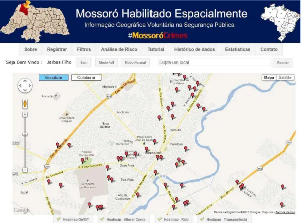
The developed system consists of a prototype to collect VGI data and perform statistical analysis of VGI data and by geographic region. The software was developed to support requests coming from computers (laptop, desktop) and smartphones that support Android or Iphone operating systems. Figure 1 shows the system interface that uses only HTML and CSS in its development to make viewing very simple in devices that have limited screen such as mobile devices.
The system provides two categories: security and others. At the time the user performs collaboration he can tell which category and type of occurrence that he will provide. The category "other" represents other data that have some connection with the area of public security, for example, report lack of lighting on a street. Figure 2 shows statistical analysis on the collaborated data by categories and on users who cooperated more. Then it is possible to have a control over the most active users and filter, in the database, the information of these users in order to try to identify whether the user is collaborating to help or disturb police activities.
15
The identification of risk areas is essential when the topic is public security. The Google Maps API provides resources to implement services for risk analysis based on Kernel Map, which is a statistical method of estimation of curves, i.e., is plotted on the map using interpolation methods, the intensity of a particular phenomenon in the region (KERNEL MAP, 2012). The system has a button called "heatmap" to enables the function that implements the Kernel Map. Moreover, as the user moves the map it is possible to view the statistics of VGI data by region. Figure 3 shows the use of Kernel Map in recorded incidents.
Figure 2 - Statistical analysis by category and user
Because there are few collaboration, it is not possible to infer any relevant result on the Kernel map. From the moment that there is more collaboration in the system it will be possible to see the color intensity by region.
16
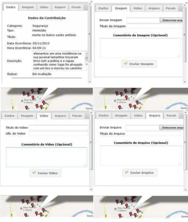
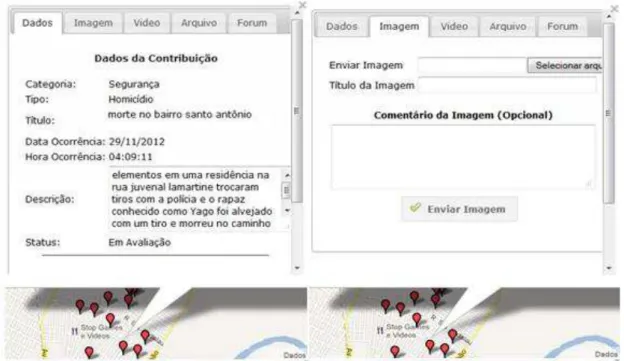
photo, video or any other file. Figure 4 shows the "infowindow" of collaboration module with the tabs to send multimedia files. Mossoró has Streetview service. The citizen can use this service to better identify the place for registration of the occurrence.
Figure 3 - Risk analysis based on Kernel Map
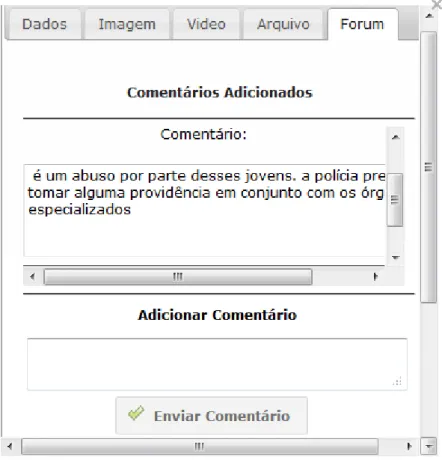
Once the user registers the collaboration by clicking on "send collaboration" it is created a forum about the data. To interact with the forum, the user must be "logged in" to the system. Therefore, any registered user can interact with other users and provide extra information that was not addressed in the description of the occurrence. This generates a collective intelligence about the data, similar to those that exist in relevant comments in posts on social networks, whose goal is to help in the description of a photo, text, video or other.
17
Figure 4 - Infowindow of collaboration module
6 CONCLUSION AND FUTURE WORKS
A collaborative Web system is essential for citizens to share information that are often available on websites that do not have the knowledge of agencies in charge of public security. A society enabled with VGI data on public security can be useful for companies, citizens and government using another database to improve the decision-making process. VGI data being used at a local level, which is highly recommended, can provide a faster response to security departments than their own official data. Therefore, in an emergency situation it is possible to get better results in the execution of activities.
18
conducted comparing the VGI data with official data to assess the impact of VGI in security.
ACKNOWLEDGEMENTS
This project was partially funded by CNPq, Fapemig, CAPES, Funarbe and the Company Sydle.
REFERÊNCIAS
19
2.2. Artigo II: Qualitative Analysis of Volunteered Geographic Information in a Spatially Enabled Society Project
Jarbas Nunes Vidal-Filho, Jugurta Lisboa-Filho, Wagner Dias de Souza e Gerson Rodrigues dos Santos
In: Cities, Technologies and Planning (CTP 13) in Conjunction with the International Conference on Computational Science and Its Applications (ICCSA). Artigo aceito para publicação.
RESUMO
O aumento das fontes de dados na Internet e os avanços da Web 2.0 têm contribuído para mudanças significativas na forma de se produzir informação espacial. O cidadão está utilizando ambientes colaborativos para produzir seu próprio dado, seja na área de segurança pública, infraestrutura ou para simples diversão. A contribuição voluntária é essencial para tornar uma sociedade habilitada espacialmente e ajudar no processo de tomada de decisão em todos os níveis de uma sociedade, seja governamental, privado ou pelo próprio cidadão. Analisar o ganho de informações que são registrados nos sistemas Web colaborativos é essencial para se conhecer o que não está sendo registrado nas fontes de dados oficiais. O objetivo do trabalho é avaliar o ganho de informações geradas pelo próprio usuário em um projeto de transformação de uma gestão municipal informatizada convencional para uma sociedade espacialmente habilitada.
Palavras-chave: Informação Geográfica Voluntária, Sistemas Web, Sistema de Informação Geográfica, Segurança Pública.
ABSTRACT
The increase of data sources on the Internet and Web 2.0 advances have contributed to significant changes in the way we produce spatial information. The citizen is using collaborative environments to produce their own data, whether in the area of public security, infrastructure or for simple fun. The voluntary contribution is essential to make a spatially enabled society and help in decision-making process at all levels of a society, whether governmental, private or by the citizen. Analyzing the information gain that is recorded in collaborative Web systems is essential to know what is not being recorded in official data sources. The aim of this study is to evaluate the information gain generated by the user on a project to transform a conventional computerized municipal management for a spatially enabled society.
20 1 INTRODUCTION
Most Brazilian cities have gone through many problems in the public security area. Several cases of violence are constantly reported in newspapers, magazines and other media. Given this, the public security issue is being treated as a priority of governments and has become a research subject in several areas. The academy and the public security organs have advanced the development of new tools that can support decision making in the public security sector, whose aim is to fight crime.
The use of Geotechnologies applied in the area of public security is utilized by various organizations to combat violence. Therefore these geoprocessing tools have become essential in the process of decision making. Public security agencies have obtained good results with the use of tools of Geographic Information System (GIS). These results have been useful in improving the activities in police departments. However, some departments have problems that prevent the access to spatial information or the dissemination of spatial data.
Mossoró is a Brazilian city located in the western Rio Grande do Norte state, with about 260.000 inhabitants (IBGE, 2013). In recent years, the Technical Institute of Police (ITEP) has recorded alarming numbers of homicides (e.g. murder), drug traffic, among others (ITEP, 2013). From this, it was realized the need to create a computing platform that would help in making decision process of the police in the city of Mossoró. This platform would approximate people to the police and would make users the producers and reviewers of data about public security in their neighborhood or street. Each user can make denunciations, record occurrences that he/she witnessed or heard by others and share any other useful information to security departments.
21
In a spatially enabled society, location, services and spatial information are available and accessible to citizens, private companies and governments as means of organizing information and activities in the decision making process (WILLIAMSON, et al., 2012). According to Khoo and Yee (2010), this kind of society provides a coordinated effort in the production, storage, dissemination and use of spatial data at all levels of that society. This type of environment should allow users access regardless of the computational platform and can be improved with the voluntary participation of users in the production of geospatial data.
For the development of this society, it is necessary the use of spatial data. They need to be sufficiently reliable, easily accessible and available in real time (RAJABIFARD, 2008). The developed system allows people with Internet access to query the recorded data and voluntarily collaborate with geospatial data about the public security of the city of Mossoro. The aim is to generate data that are not often recorded in the databases of the agencies responsible for public security. According to Coleman (2010), this possibility that allows users to search and contribute to spatial information is crucial for a vision of a spatially enabled society.
The production of spatial data by any citizen of a society happened due to the advances of Web 1.0 to Web 2.0. At Web 1.0, it was able to view more information consumers than producers. The producers were largely people specialized in computer science or geosciences. With advances in Web 2.0, there was a greater number of data producers. Anyone with access to the Internet can produce information (BUGS, 2012). Some typical examples of the use of Web 2.0 are: Wikipedia, blogs and social networks. The collaborative systems are crucial for the production of information. In this kind of system there is greater interaction among a user or groups of users to produce information (FURTADO et al., 2010). This type of collaborative environment has been essential to the production of spatial data in a spatially enabled society. Increasingly users are generating content based on their geographic coordinates to aid in the process of decision making by a particular organization.
22
Neogeography, Collective Intelligence and Web 2.0. The concept of VGI can be described as a set of spatial data that are not produced by individuals and organizations specialized in the production of spatial data, but by people who use Web 2.0 tools to disseminate geospatial information (ELWOOD; GOODCHILD; SUI, 2008). In MossoróCrimes system, the user himself/herself spends some of his/her time to produce his/her VGI data, reporting or recording police incidents that occur in his/her region. It is expected ethics from users of MossoróCrimes in the production of VGI.
Geography took other paths with the use of Web 2.0 techniques. It allowed that people without technical knowledge could create and overlay their own data. Thus, the term Neogeography was determined by Eisnor (2012) to describe this new way of working the geography along with Web 2.0 resources. In collaborative systems, data can be produced from voluntary contributions among people. These, together, exchange knowledge for data production, such as those that are found in the Wikis systems (CHAVES; STEINMACHER; VIEIRA, 2011). So, this exchange of knowledge among users in collaborative environments is called Collective Intelligence (HUDSON-SMITH; CROOKS; GIBIN, 2009).
The aim of this study is to collect VGI data in order to statistically analyze the benefits of VGI for the public security departments in the city of Mossoró. Contributions received were considered in isolation, in order to know the information gain in the system. Furthermore, VGI data were compared with the official data from the Integrated Center of Public Security Operations (CIOSP) of Mossoró, which is the agency responsible for recording the police incidents reported by the citizen via telephone. The rest of the paper is organized as follows. Section 2 describes the project Mossoró Spatially Enabled and presents the system MossoróCrimes. Section 3 presents the mechanisms to ensure the quality of VGI. Section 4 shows the results of statistical analyzes on the data of MossoróCrimes and the comparison with data from CIOSP. Section 5 presents some conclusions and future studies.
2 PROJECT OF A SPATIALLY ENABLED SOCIETY
23
Mossoró on October 10, 2012 and recorded the presence of local and regional press, authorities of police departments, professors, researchers and students interested in supporting research on public security in Mossoró. The platform developed in this project is the system MossoróCrimes (www.ide.ufv.br/mossorocrimes). It remains open for contributions record, but for this study, it was defined a period of two months (October 10, 2012 to December 10, 2012) to conduct statistical studies.
2.1. The System MossoróCrimes
The collaborative Web system known as MossoróCrimes is a computational platform connecting people to the data on the project Mossoró Spatially Enabled. This system uses the Google Maps platform to provide the digital map of the city of Mossoró and anyone with Internet access can fulfill a voluntary collaboration. Using programming languages HTML and CSS, it was developed a simple interface to facilitate access by the users with devices with limited resources, and it was also used the JavaScript language to perform the customization of the Google Maps API v3. Figure 1 shows the system interface.
24
The system has a module of collaboration that allows users to register the data of VGI (Figure 2). This module was developed using programming languages PHP, JavaScript, HTML and XML. The collaboration module receives textual information that represents the general data (date, time, subject, description, etc.) about the occurrence, multimedia information (video and photo) and extra files that may contribute to the collaboration. All information is stored and managed by database management system Mysql Server.
25
Figure 2 - Module of Collaboration
3 QUALITY OF VOLUNTEERED GEOGRAPHIC INFORMATION
26
poor quality of commercial or governmental producers. For example, in the database of CIOSP - Mossoró virtually all data are supplied via telephone calls, and most of them are anonymous phone calls. Therefore, there is also a risk when using official data.
Thus, one should not dismiss the use of VGI, as these can be useful in the decision making process, in the improvements in police activities and in the violence prevention.
Several projects that use data generated by users are able to gain credibility for their end users such as Wikipedia, Wikimapia and OpenStreetMap. The latter two perform the world mapping collaborative. They went through a long process of acceptance. Now they use mechanisms to monitor the quality of VGI and require user awareness in collaboration to achieve a level of overall satisfaction.
According to Goodchild (2009), the geographic aspects of VGI have some degree of quality not found in other types of user generated content. Geographic data are widely used to perform analysis on a certain location. Sometimes there are no spatial data available for the manager to perform the procedures of decision making. For Elwood, Goodchild and Sui (2008), when there is no data, VGI gains greater importance, since it makes possible to perform some kind of analysis, albeit with questionable quality. Goodchild (2012) draws attention to the need to develop mechanisms to ensure the quality of VGI data using Wikis concepts, Collective Intelligence or Crowdsourcing. The latter can be understood as a crowd of people producing data to use in a particular application (HOWE, 2008).
Police in the city of Mossoró has an official database about crimes, but it is known that not all data are recorded. The idea of approach the citizen with the police is to make him/her provide data that in most cases the police doesn’t receive such as denunciations about drug traffic, murderers, etc. In collaborative systems there is the problem of being provided false information, which may disturb police work. Thus, the system MossoróCrimes implements two mechanisms to monitor the quality of VGI. These mechanisms are described in the following subsections.
3.1. Mechanism Based on Assigning Grades
27
mechanism for providing quality to the VGI. Each collaboration has a interface as shown in Figure 3.
Figure 3 - Service of grade for evaluation the collaboration
3.2. Mechanism Based on Concepts of Collective Intelligence
The second mechanism introduced in the system MossoróCrimes is a forum for each collaboration. The idea is to use the concepts of collective intelligence to monitor data quality. It is possible to improve collaboration recorded through the exchange of knowledge between different users, but it can also destroy the credibility of it.
28
Figure 4 - Forum of the collaboration
4 STATISTICAL ANALYSIS OF VGI DATA
The data analyzed in this article correspond to VGI collected by the system MossoróCrimes in a period of 60 days, starting on the project's launch. In collaboration module the system MossoróCrimes the user initially faces two broad categories (Security & Others) regarding the inclusion of contributions. Each category (e.g. security) is also classified by type of occurrence (e.g. theft). The categories and types are chosen from a window in the shape of combobox, i.e., the user simply select the category and type want he/she wants to collaborate with.
29
4.1. VGI Data Analysis of the System MossoróCrimes
This section provides a general discussion of the data that the system collected and analyzes the information gain for the system itself with the contributions that were recorded. Furthermore, it presents analysis representing the user's interaction with the contributions already registered. For this, it is analyzed the gain of images, videos, extra files, the average views of contributions, the number of users who used the service of grades and the forum in contributions.
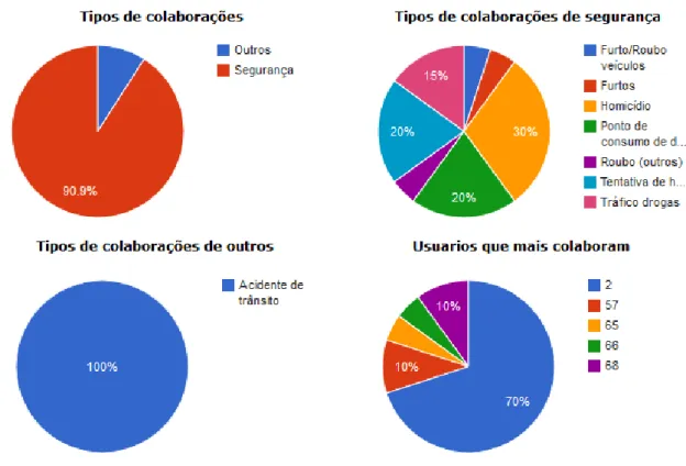
4.1.1. Analysis of Contributions by Category
During the study period (60 days) 74 contributions were collected. 66 contributions in the Security category and 8 contributions in the category Others. In addition, the system had the registry of 97 users. Table 1 shows the percentage of registration for each category.
Table 1 - Percentage of record for each category
Category of system Percentage (%)
Security 89.2
Others 10.8
The Security category received the highest number of contributions, because the types of occurrences associated with this category are the types directly related to public security. Thus, it was the category most in demand by users to register their VGI data. Furthermore, it can be stated that 42.42% of the information recorded in the Security category were not in the CIOSP databases.
4.1.2. Analysis of Contributions by Period
30
category and 5 in the Others category. Table 2 shows the percentage of registry in each category during the first and second month.
Table 2 - Percentage of record of each category during the first and second month
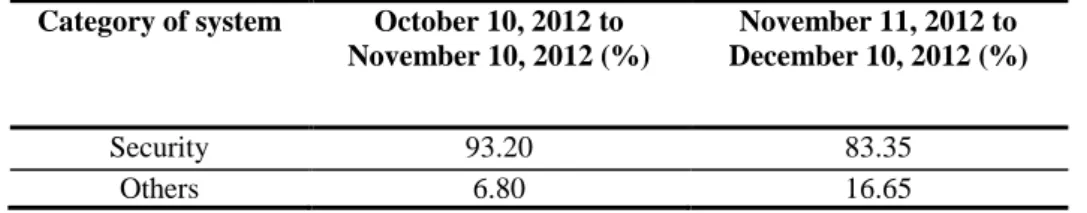
Category of system October 10, 2012 to November 10, 2012 (%)
November 11, 2012 to December 10, 2012 (%)
Security 93.20 83.35
Others 6.80 16.65
During the first month there was a greater amount of collaborations. This occurred because of the launch of the project in the city of Mossoró, which mobilized much of the press for publication. After launch, the authors used the Blog O Camera (www.ocamera.com.br), a police blog, to continue to publicize the system and invite users to collaborate on the platform MossoróCrimes. It was used the free tool Google Analytics to analyze the number of accesses to the system. It was found that in the first month there was more access. The next month the system recorded peaks of access when the system was broadcasted by commenting on the news in the police Blog “O Câmera”.
One can also see that in the second month there was an increase in the number of records in the Others category. It is believed that, over time, people begin to learn more about the tool and find that they can collaborate with other information, such as lack of policing, public place in poor condition and other contributions that are indirectly linked to the area of public security. Therefore, it can be stated that 62.5% of the information recorded in the Others category were not in the CIOSP databases.
4.1.3. Analysis of Contributions by the Type of Incident
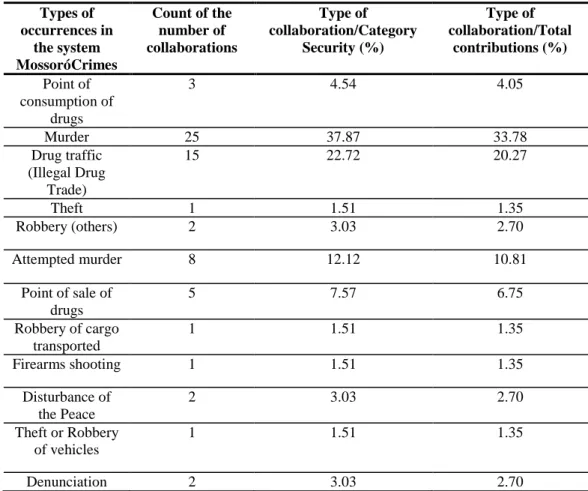
Each category registered in the system contains a kind of incident associated. In the Security category types were defined with the aid of a policeman of CIOSP - Mossoró.
31
of record related with the data registered in the Security category and with the total data recorded in the system.
Table 3 - Statistical returns by type of collaboration in the category Security
Types of occurrences in
the system MossoróCrimes
Count of the number of collaborations Type of collaboration/Category Security (%) Type of collaboration/Total contributions (%) Point of consumption of drugs
3 4.54 4.05
Murder 25 37.87 33.78
Drug traffic (Illegal Drug
Trade)
15 22.72 20.27
Theft 1 1.51 1.35
Robbery (others) 2 3.03 2.70
Attempted murder 8 12.12 10.81
Point of sale of drugs
5 7.57 6.75
Robbery of cargo transported
1 1.51 1.35
Firearms shooting 1 1.51 1.35
Disturbance of the Peace
2 3.03 2.70
Theft or Robbery of vehicles
1 1.51 1.35
Denunciation 2 3.03 2.70
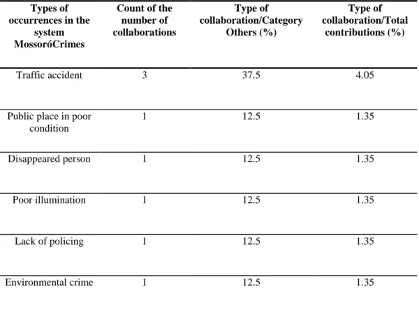
Table 4 uses the same methodology of Table 3. It only shows the setting of analysis used in the Security category for the category Others.
32
Table 4 - Statistical returns by type of collaboration in the category Others
Types of occurrences in the
system MossoróCrimes
Count of the number of collaborations
Type of collaboration/Category
Others (%)
Type of collaboration/Total
contributions (%)
Traffic accident 3 37.5 4.05
Public place in poor condition
1 12.5 1.35
Disappeared person 1 12.5 1.35
Poor illumination 1 12.5 1.35
Lack of policing 1 12.5 1.35
Environmental crime 1 12.5 1.35
4.1.4. The gain with Photo and Video Information
It is observed that of the 74 contributions received during the period of 60 days, 27 collaborations possessed extra information in image format. Each contribution accepts one photo, so 36.48% of the contributions of the system received images. These represent extra or additional information on collaborations. This represents more information to police agencies try to solve a case based on the VGI data and provides more credibility to VGI.
33 4.1.5. The Gain with Information of Extra Files
A registered contribution may contain a photo or video. If another user has one more picture, video or any other file to insert into the collaboration, he/she should insert on the tab files of the contribution. The collaboration supports much information upon registration. So it can happen that user is not able to enter all data collaboration.
Analyzing the 74 recorded contributions, only 1 received extra files, then, merely 1.35% of the collaborations received extra files. It may seem few, but for a sector where information is practically scarce, it can be considered that this contribution as a reasonable gain depending on the quality of information.
4.1.6. The Gain with Information from Comments of the Forum
The forum in each contribution functions as a mechanism of quality of the VGI. This forum aims to receive additional information about the occurrences, similar to the idea of collaboration on collaboration, as in blogs, where the collective intelligence is used to discuss the data and improve the quality of information. Analyzing the registered contributions, 24.32% of them received extra comments.
4.1.7. Number of Users that Collaborated
During the experiment, the system received the registry of 97 users, which provided a name, email and password. Among them, only 20 users inserted a contribution to the system, which represent 20.60% of the registered users. Analyzing the records of each user, it was found that each region of the Mossoró map had one or two users to record information about their neighborhood. By the user identifier in the database, it was possible to assess how behaved the records of a particular user in the city. And by the Google Analytics tool, it was noticeable that most users just visualized the home of the website, perhaps for fear of register and have their data stored, even with the possibility of creating a fictitious name.
4.1.8. Evaluation of Collaborations
34
assessed, representing 44.59% of them. And of the 97 registered users, it was noted that only 7.20% of users rated the collaborations. Analyzing the database, among collaborations evaluated, 75.75% were evaluated only one time, while 24.25% were evaluated more than once. The low number of users evaluating contributions may have occurred for two reasons. They didn’t know any information about the occurrences or they didn’t have the necessary knowledge of this tool.
4.1.9. Viewed Collaborations
The system records the number of viewing of each occurrence as a way to track whether users are querying them and to create a ranking of most viewed collaborations. Analyzing the database, it was found that 100% of recorded contributions were viewed. The number of views for most recent collaborations was around 15 views per contribution. And for older ones, it exceeded the number of 50 views per each.
The project was well publicized initially and received a higher number of users in the first month. This factor explains why older collaborations were more accessed, because they were the collaborations that users were initially. Analyzing Google Analytics, over time the number of users accessing the system was much lower, which made the number of views of collaborations decrease. The system needs a validation of the police trying to solve some registered occurrences, so users tend to believe more in the tool. Therefore there may be a continuous participation by users.
4.2. Comparing Data of the System MossoróCrimes with Official Data of CIOSP
35
During the study period, 74 contributions of VGI on the system MossoróCrimes were recorded and, in the same period, 5650 police occurrences were reported at the base of CIOSP. However, comparing the two databases, it is observed that 33 contributions of the system were not recorded in the CIOSP data, representing that 44.59% of VGI data recorded in the system MossoróCrimes were not in the CIOSP official data.
Analyzing these 33 contributions that have not been registered at the CIOSP base and were at the base of MossoróCrimes, there were 28 unregistered collaborations on Security category, and 5 collaborations in Others Category. This occurred because this category is responsible for receiving the types of occurrences that are directly related to public security, so it was much more used. The following subsections make an analysis of the registration number of each type of occurrence on Security category of the system with CIOSP official data.
4.2.1. Analyzing the Security Category
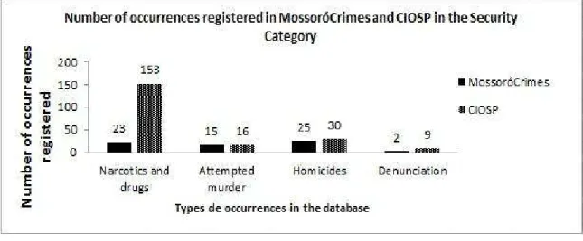
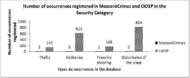
The Security category collected all types of occurrences that were previously shown in Table 3. Each type in this category was compared with the corresponding type in the CIOSP database to know the number of records for each type of occurrence in the database. Figures 5 and 6 show the number of records for each type of occurrence in MossoróCrimes and CIOSP databases.
36
The CIOSP has a kind of occurrence called Narcotics and drugs which includes 3 types of occurrences of Security category on MossoróCrimes which are: Point of sale of drugs, Point of consumption of drugs and drug traffic. To perform this comparison, we adopted a join operation in the 3 types of occurrences of MossoróCrimes turning it into a single type of base like CIOSP. Figure 5 shows a well-balanced record number between the two bases. It is because they are the most common types and alarming of occurrences in the city of Mossoró. Drug traffic is directly reflected in the number of homicides and attempted murder that occur in the city of Mossoró and the denunciations made to the system were related to the subject drug or homicide. Therefore, there has been a major concern for users to record these types of occurrences. In Figure 6 it can be seen that there is a greater discrepancy between the data recorded in the MossoróCrimes system and the CIOSP database. It is believed that the fact that the system has received fewer records regarding the types of occurrences of Figure 6 is explained by these occurrences requiring more urgency to be solved. These are incidents recorded by the police phone and the citizen usually requires the presence of the police in time to solve the case.
Figure 6 - Comparing the number of record in databases of MossoróCrimes and CIOSP