Adv. Sci. Res., 8, 93–97, 2012 www.adv-sci-res.net/8/93/2012/ doi:10.5194/asr-8-93-2012
©Author(s) 2012. CC Attribution 3.0 License.
Advances
in
Science & Research
Open Access Proceedings
EMS
Ann
ual
Meeting
and
10th
European
Conf
erence
on
Applications
of
Meteorology
(ECAM)
2011
Quality assessment of heterogeneous surface radiation
network data
R. Becker and K. Behrens
Deutscher Wetterdienst, Meteorologisches Observatorium Lindenberg/Mark, Am Observatorium 12, 15848 Tauche, Germany
Correspondence to:R. Becker ([email protected])
Received: 15 January 2012 – Accepted: 11 April 2012 – Published: 27 April 2012
Abstract. The DWD national radiation measurement network comprises 82 automatic sites, 29 manned sites with shaded and unshaded pyranometer and the BSRN station at Lindenberg. The quality assessment routinely applied takes into account the basic astronomical and empirical considerations as well as some interdependen-cies like total to diffuse flux relation and cross checking with sunshine duration.
A more advanced quality assessment approach attempts to routinely utilise timeseries of clear sky radiative transfer simulations for every site. For that purpose a link to cloud coverage obtained from Meteosat second generation geostationary satellite data, highly resolved in time and space, was established. There is a predefined calibration cycle of 30 month for automatic stations. Data analysis on this timescale allows for the detection of sensor degradation, wrong calibration or configuration and other possible local disturbances. Furthermore using satellite cloud mask enables the identification of larger clear sky regions characterized by similar at-mospheric conditions. Thus, in a regionalization step correction or recalibration of moderate quality data to a higher level can be considered.
The paper provides an overview of DWD surface radiation network and the current activities to improve au-tomatic quality assessment using remotely sensed data and clear sky modeling for the upgrading of radiation data.
1 Introduction
Irradiance is a key parameter in Earth’s weather and cli-mate system. Accurate observations of the components of the near surface radiation budget are therefore essential IPCC (2007). For the achievement of a global coverage the utilisation of satellite-based retrievals have become an im-portant part. Such retrievals are developed and data are pro-vided in the framework of EUMETSAT’s Satellite Appli-cation Facilities like SAF on Climate Monitoring (Mueller et al., 2009) and LandSAF (Trigo et al., 2011). Even though not needed as a direct input but indispensable for testing, val-idation and adaptation of satellite-based algorithms are accu-rate ground-based observations. High quality ground-based measurements are performed in the context of the baseline surface radiation network (BSRN, Ohmura et al., 1998). The Deutscher Wetterdienst (DWD) is operating the national
ra-diation network which is a heterogeneous collection of sites measuring downward shortwave radiation. The network is hosted by Meteorological Observatory Lindenberg.
This paper deals with the progress made in quality assess-ment of the radiation network data due to the following ac-tivities:
– by using satellite data input of cloud coverage – by comparing measured quantities to simulated
ones in clear-sky conditions
2 The ground-based network
Figure 1.Shaded pyranometer (left picture) and Scanning Pyrhe-liometer/Pyranometer (right) on the radiation measurement plat-form at Lindenberg observatory.
equipped with two Kipp & Zonen CM11 or CM21 pyra-nometer (Kipp & Zonen, 2004) to measure diffuse (shaded) and total (unshaded) downward shortwave radiation (0.3– 2.8µm). Instrumentation is categorised as secondary
stan-dardaccording to ISO 9060 orhigh qualitywith respect to WMO classification. CM 21 response time is 5 s for 95 % of responses, less than 15 s for CM 11, respectively. 11 sites are equipped additionally with Kipp & Zonen CG4 pyrgeometer to cover the spectral range from 4.5 to 45µm (Kipp & Zonen,
2001). SCAPP (scanning pyrheliometer and pyranometer) is a low-cost instrument to measure diffuse and direct irradi-ances developed by DWD and manufactured by Siggelkow Germany (Fig. 1). It was designed for automatic mode and operates without outer sun shading and outer moving parts. The spectral coverage is limited to 0.3 to 1.1µm due to the
use of a silicon detector. For daily sums of downward short-wave radiation an accuracy of 10 % is expected (20 % for hourly sums, Bergholter and Dehne, 1994). Figure 2 provides an overview of the DWD ground-based radiation measure-ment network.
The calibration of the field/network pyranometers is per-formed at the RRC/NRC at Meterological Observatory Lin-denberg (MOL) indoor referring to ISO 9847:1992 “Solar energy – Calibration of field pyranometers by comparison to a reference pyranometer”. SCAPPs are calibrated at MOL locally too, but outdoor only between the Northern Hemi-sphere spring and autumn equinoxes using direct and dif-fuse irradiance measured by the station pyrheliometer and shaded pyranometer. All calibrations are tracable to World RadiationReference (WRR).
Indoor calibration capability – to get independent from the season – is under development. A more detailed analysis of SCAPP functionality is given in Behrens and Grewe (2005).
3 Scheme for automatic quality assessment
The core conventional data analysis currently operated refers to the proposal given by Long and Dutton (2002) with regard to BSRN (Ohmura et al., 1998). This will be complemented by a procedure checking overall data status (sensor
degra-Figure 2.Ground based network for irradiance measurements, lo-cation and characterisation of sites. Green circles indicate short-wave total (G) and diffuse (D) component measured by pyranome-ters, pink indicates the same plus atmospheric longwave radia-tion (A). Blue: sites equipped with SCAPP.
dation, systematic disturbances like restrictions of full sky view) described in the following sections. It makes use of an independant approach for detection of clear-sky episodes at measurement site operating daily (Sect. 3.1). For the sites labelled as clear simulation of expected downward short-wave radiation will be performed using a simplified radiative transfer model setup (Sect. 3.2). First results using BIAS-corrected reference values are given in Sect. 4.
3.1 Utilisation of satellite data
Current geostationary satellite imagery is provided with tem-poral resolution of 15 min and a footprint size of 3 km at nadir view (Schmetz et al., 2002). EUMETSAT’s Satellite Application Facility on Nowcasting and Very Short Range Forecasting is developing algorithms to routinely process data of MSG-SEVIRI. Retrieval of cloud mask and cloud type is based on pixel-by-pixel analysis on original satellite projection by means of multispectral thresholding method (Derrien and LeGleau, 2005). Static and dynamic thresholds are precomputed from geographical, climatological and fore-casted data.
noon. Then following simple extraction criteria are applied:
Nave<2 octa && DatAvail≥66 %
whereNave is the averaged total cloud coverage at location
and DatAvail is the ratio of valid MSG cloud cover estimates in the predefined time window. This is to ensure that aver-aged cloud cover represents the whole time frame and is not biased due to greater lack of data. Figure 3 displays exam-plary output of total cloud cover calculation. Referring to satellite data to characterise the cloud coverage at site instead of taking the radiation measurements itself yields some ad-vantages:
– conventional methods like evaluation of the ratio of
dif-fuse and total irradiation might fail if at least one pa-rameter is disturbed, potential detection of such misbe-haviour could be prevented
– a homogeneous method is applied for all ground station
independant of its instrumentation
– evaluation of satellite pixels enables a full sky view, i.e.
all sky segments as seen by upward-looking instrument are checked for cloud contamination
Some potential drawbacks need to be mentioned here, too. The footprint (sampling distance) of SEVIRI radiometer is 3 km at nadir view and resolution gets coarser towards north and south. It might effect in an underestimation of small cu-mulus clouds (Cumulus humilis). To exclude such cases from clear-sky evaluation the variability of the ground-based sig-nal is checked additiosig-nally. Secondly, very thin cirrus from time to time remains undetected, but no strong affection is expected here.
3.2 Simulation vs. measurement
Clouds strongly affect the radiation field and therefore in-fluence the measurements of shortwave total and diffuse ir-radiance. Simulations of arbitrary meteorological scenes re-quires detailed knowledge of microphysical cloud properties that can hardly be provided in appropriate quality for the whole region of interest. Best matches between calculated and measured quantities can be expected for clear-sky con-ditions when direct component of solar radiation dominates the total (global) radiation. The focus was set on the insola-tion time frame ranging from 10:00 to 13:00 UTC. Calcula-tion of incoming shortwave radiaCalcula-tion is done using radiaCalcula-tion transfer code Streamer (Key, 2001). The setup for the model only roughly distinguishes between winter and summer mid-latitude atmosphere. It runs with climatological ozone and background tropospheric aerosol.
For the comparison study data of pyranometer sites of the period May 2010 to August 2011 were selected, resulting in a total number of 560 cases. Time series of calculated total ra-diation in general shows a good correspondence to measured
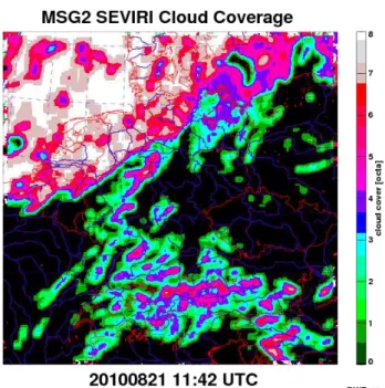
Figure 3. Total cloud coverage from MSG based on pixel-by-pixel analysis using NWCSAF algorithm, mapped onto COSMO-DE model domain and calculated for a 9×9 pixel matrix.
S
W
r
a
d
ia
ti
o
n
t
o
ta
l
Figure 4.Timeserie of calculated and measured shortwave down-ward radiation for the pyranometer site Arkona, located at the coast of the Baltic Sea. Bad weather periods cause data gaps, like in Au-gust and November/December 2010 and August 2011 as well.
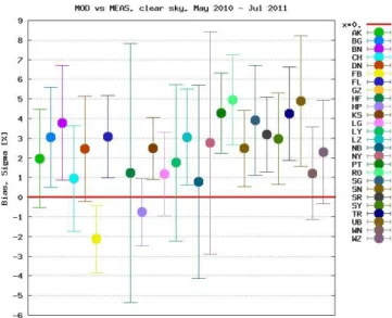
quantities (Fig. 4). Periods of enduring bad weather condi-tions cause a further reduction of evaluable data. The distri-bution of differences simulated vs. measured is displayed in the left of Fig. 5. The model tends to give higher estimates even though some negative deviations are present, too. Same is indicated by the relative bias of 1.02.
Figure 5.Systematic deviations of calculated and measured irra-diances averaged from 10:00–13:00 UTC for pyranometer sites. A distinct peak can be found at positive differences (measured sub-tracted from modeled).
Figure 6.Systematic discrepancy and standard deviation of model calculations of downward total shortwave radiation from measured quantities, given for all pyranometer sites, expressed in percent.
Almost all stations show an overestimation by the model, ex-cept two mountaineous sites located on top of low moun-tain summits (Fichtelberg 1214 m a.s.l., Hohenpeissenberg 988 m). In other words, lowland stations are receiving less radiation than calculated, however mountaineous get more. It is explained by the fact that calculations were performed assuming a fixed height above sea level (120 m a.s.l.). This finding means that the model setup will need further adjust-ment for actual station elevation.
A summary of the results is provided in Table 1. The model generally slightly overestimates, but filtering for in-strument category draws a different picture for pyranometer and SCAPP: the systematic deviation is almost doubled for the latter. This is possibly due to less long-term stability of the sensors, but needs to be further investigated with regard to calibration procedure too. However, the higher variability
Table 1.Statistics of comparison model-measurement, instrument classes treated separately. The model overestimates for both cate-gories, but difference is larger for SCAPP.
Pyranometer SCAPP
Bias +2.40 % +4.29 %
Sigma 3.36 % 4.61 %
500 600 700 800 900 1000 1100 1200
0521 0604 0618 0702 0716 0730 0813 0827 0910 0924 1008 500 600 700 800 900 1000 1100 1200
SW radiation [W/m2]
Date in 2011 [MMDD] total meas
total mod
Figure 7.Shortwave radiation (total) measured at site Magdeburg/ Saxony-Anhalt with SCAPP (red) and calculated (green). Note that identification of strong overestimation in July possibly due to wrong station setup caused a release of instrument substitution end of Au-gust.
meets our expectations and is inline with instrument specifi-cations (Bergholter and Dehne, 1994).
4 First applications
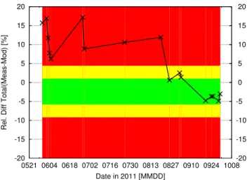
Monitoring the differences in the timeseries of calculated and measured shortwave radiances reveales possible errors in sta-tion configurasta-tion, wrong calibrasta-tion or sensor degradasta-tion. For SCAPP a calibration cycle of 30 month was predefined according to manufactorers advices. Several years of oper-ational service have shown that in practice the cycle must be set shorter. The comparison model-measurement helps to identify the right time for instrument substitution (see Fig. 7). Instrument status is a valuable information for operators and basic level quality assessment, too. Figure 8 displayes an example for a graphical realisation of instrument status for site Magdeburg (Fig. 8).
5 Conclusions and outlook
-20 -15 -10 -5 0 5 10 15 20
0521 0604 0618 0702 0716 0730 0813 0827 0910 0924 1008 -20 -15 -10 -5 0 5 10 15 20
Rel. Diff Total(Meas-Mod) [%]
Date in 2011 [MMDD]
Figure 8.Relative Difference of measured and calculated short-wave radiation at Magdeburg/Saxony-Anhalt. Green area indicates ±1σ, yellow±2σ.
Based on a dataset of real clear-sky conditions identy-fied using Meteosat/SEVIRI cloud coverage distributed over more than one year dedicated relations to simulations ac-cording to instrument group (pyranometer, SCAPP) could be found. These slight but systematic differences can be con-sidered and used to assess the quality of realtime data. Cur-rently a simple setup for the model is used. It can be expected that feeding of more realistic atmospheric profiles achieved by providing radiosoundings, filter radiometry (if available) or forecasted/analysed profiles of numerical weather predic-tion model will lead to more refined and precised results. The future consideration of the site elevation will surely cause a positive bias at the elevated stations (Fichtelberg, Hohenpeis-senberg), too. As a consequence the spread would decrease.
The approach presented here will be checked for applica-bility for overcast sky conditions.
Acknowledgements. Thanks to Michael Sommer (DWD-MOL) for fruitful discussions concerning the use of Streamer.
Edited by: I. Auer
Reviewed by: two anonymous referees
The publication of this article is sponsored by the European Meteorological Society.
References
Behrens, K. and Grewe, R.: A comparison of SCAPP radiation data with global, diffuse and direct solar radiation, in: Papers Pre-sented at the WMO Technical Conference on Meteorological and Environmental Instruments and Methods of Observation (TECO-2005), Vol. 1265, Bucharest, Romania, 2005.
Bergholter, U. and Dehne, K.: SCAPP – a compact scanning pyrhe-liometer/pyranometer system for direct, diffuse and global solar radiation, Tech. Rep. 57, WMO-IOM, 1994.
Derrien, M. and LeGleau, H.: MSG/SEVIRI cloud mask and type from SAFNWC, Int. J. Remote Sens., 26, 4707–4732, 2005. IPCC: Climate Change 2007: The Physical Science Basis.
Con-tribution of Working Group I to the Fourth Assessment Report of the Intergovernmental Panel on Climate Change, edited by: Solomon, S., Qin, D., Manning, M., Chen, Z., Marquis, M., Av-eryt, K. B., Tignor, M., and Miller, H. L., Tech. rep., Cambridge Univ. Press, UK, 2007.
Key, J.: Streamer User’s Guide, Tech. rep., Cooperative Institute for Meteorological Satellite Studies, 96 pp., 2001.
Kipp & Zonen: Instruction Manual CG4 version 0304, Download center, discontinued products, www.kippzonen.com, 2001. Kipp & Zonen: Instruction Manual CM21 version 1004, Download
center, discontinued products, www.kippzonen.com, 2004. Long, C. and Dutton, E.: BSRN Global Network recommended QC
tests, V2.0, Tech. rep., available as PDF at: http://www.bsrn.awi. de, 2002.
Mueller, R., Matsoukas, C., Gratzki, A., Behr, H., and Hollmann, R.: The CM-SAF operational scheme for the satellite based re-trieval of solar surface irradiance – a LUT based eigenvector ap-proach, Remote Sens. Environ., 113, 1012–1024, 2009. Ohmura, A., Dutton, E., Forgan, B., Froehlich, C., Gilgen, H.,
Heg-ner, H., Heimo, A., Koenig-Langlo, G., McArthur, B., Mueller, G., Philipona, R., Pinker, R., Whitlock, C., Dehne, K., and Wild, M.: Baseline surface radiation network (BSRN/WCRP): new precision radiometry for climate research, B. Am. Meteorol. Soc., 79, 2115–2136, 1998.
Schmetz, J., Pili, P., Tjemkes, S., Just, D., Kerkmann, J., Rota, S., and Ratier, A.: An introduction to Meteosat Second Generation (MSG), B. Am. Meteorol. Soc., 83, 977–992, 2002.