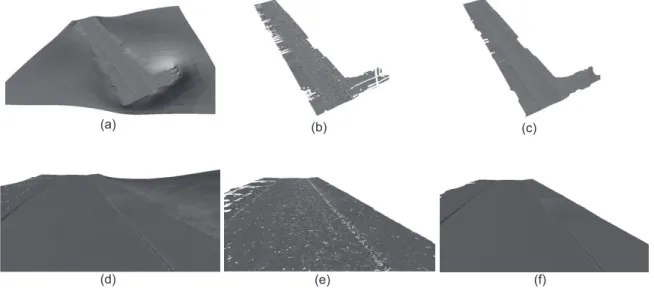
Scalable and Detail-Preserving Ground Surface Reconstruction from Large 3D Point Clouds Acquired by Mobile Mapping Systems
Texto
Imagem
Documentos relacionados
Fragment of the supercell around the vacancy, illustrating the diusion pathway: (a) initial ground state, (b) saddle-point (split-vacancy) and (c) nal ground state.. The
applied as the extractant and octanol worked as cloud point revulsant and synergic reagent for extraction, which lowered the cloud point temperature of Triton X-114 and assisted
This work, carried out with an integrated method- ological approach, focuses on the use of near surface geo- physics techniques, such as ground penetrating radar and
Spectral features: In this study colour features and gray level co-occurrence matrix (GLCM) based texture features are considered to measure the pixel similarity
Time spans from the point of subvisible cloud formation to the point where the clouds become visible (solid curves) and lower- limit timescales for sedimentation of ice particles out
This paper proposed a coded sequence pattern for automatic matching of LiDAR point data, the methods including SIFT features, Otsu segmentation and Fast
For obtaining better accuracy, some improvements and future works is required: solving hardware restriction of the camera trigging control to higher rate for increasing the speed
The foremost challenge in parameterizing subgrid convective clouds and cloud systems in large-scale models is the many coupled, physical processes (i.e., radiation and surface
