AMTD
2, 781–824, 2009Improved tropospheric NO2 retrieval for satellite
observations
Y. Zhou et al.
Title Page
Abstract Introduction
Conclusions References
Tables Figures
◭ ◮
◭ ◮
Back Close
Full Screen / Esc
Printer-friendly Version
Interactive Discussion
Atmos. Meas. Tech. Discuss., 2, 781–824, 2009 www.atmos-meas-tech-discuss.net/2/781/2009/ © Author(s) 2009. This work is distributed under the Creative Commons Attribution 3.0 License.
Atmospheric Measurement Techniques Discussions
Atmospheric Measurement Techniques Discussionsis the access reviewed
discussion forum ofAtmospheric Measurement Techniques
An improved tropospheric NO
2
retrieval
for satellite observations in the vicinity of
mountainous terrain
Y. Zhou1, D. Brunner1, K. F. Boersma2, R. Dirksen2, and P. Wang2
1
Empa, Swiss Federal Lab. for Materials Testing and Research, D ¨ubendorf, Switzerland 2
Royal Netherlands Meteorological Institute, KNMI, De Bilt, The Netherlands Received: 4 March 2009 – Accepted: 5 March 2009 – Published: 10 March 2009 Correspondence to: D. Brunner ([email protected])
AMTD
2, 781–824, 2009Improved tropospheric NO2 retrieval for satellite
observations
Y. Zhou et al.
Title Page
Abstract Introduction
Conclusions References
Tables Figures
◭ ◮
◭ ◮
Back Close
Full Screen / Esc
Printer-friendly Version
Interactive Discussion Abstract
We present an approach to reduce topography-related errors of vertical tropospheric columns (VTC) of NO2 retrieved from the Ozone Monitoring Instrument (OMI) in the
vicinity of mountainous terrain. This is crucial for reliable estimates of air pollution levels over our particular area of interest, the Alpine region and the adjacent planes, where 5
the operational OMI products exhibit significant biases due to the coarse resolution of surface parameters used in the retrieval. Our approach replaces the coarse-gridded surface pressures by accurate pixel-average values using a high-resolution topography data set, and scales the a priori NO2 profiles accordingly. NO2 VTC reprocessed in
this way for the period 2006–2007 suggest that the current Dutch OMI NO2 product 10
(DOMINO) underestimates NO2over the Po Valley in Italy and over the Swiss plateau by about 20% in winter and 5% in summer under clear-sky conditions (cloud radiance fraction<0.5). A sensitivity analysis shows that these seasonal differences are mainly due to the different a priori NO2 profile shapes and solar zenith angles in winter and summer. The comparison of NO2columns from the original and the enhanced retrieval
15
with corresponding columns deduced from ground-based in situ observations over the Swiss plateau and the Po Valley illustrates the promise of our new retrieval. It partially reduces the underestimation of the OMI VTCs at polluted sites in winter and fall and generally improves the agreement in terms of slope and correlation at rural stations. It does not solve, however, the issue that the OMI DOMINO product tends to overestimate 20
very low columns observed at rural sites in spring and summer.
1 Introduction
Nitrogen dioxide (NO2) is an important air pollutant affecting human health and ecosys-tems and playing a major role in the production of tropospheric ozone (Seinfeld and Pandis, 1998; Finlayson-Pitts, 2000). Nitrogen oxides (NOx=NO+NO2) have both
sub-25
AMTD
2, 781–824, 2009Improved tropospheric NO2 retrieval for satellite
observations
Y. Zhou et al.
Title Page
Abstract Introduction
Conclusions References
Tables Figures
◭ ◮
◭ ◮
Back Close
Full Screen / Esc
Printer-friendly Version
Interactive Discussion
biomass burning, and natural sources such as microbial production in soils, wildfires, and lightning. NOx concentrations exhibit large spatial gradients due to the inhomoge-neous distribution of sources and the relatively short lifetime of NOx in the planetary
boundary layer. Observations at high spatial resolution are therefore crucial to reliably assess exposure levels and corresponding environmental impacts.
5
Complementary to ground-based monitoring networks, which provide detailed in-formation of local near-surface air pollution, satellite remote sensing can extend the spatial coverage and provide area-wide data of NO2vertical tropospheric column den-sities (VTCs). Satellite observations of tropospheric NO2using UV/VIS spectrometers
began in 1995 with the Global Ozone Monitoring Experiment (GOME) (Burrows et al., 10
1999), followed by the Scanning Imaging Absorption spectrometer for Atmospheric Chartography (SCIAMACHY) (Bovensmann et al., 1999), the Ozone Monitoring Instru-ment (OMI) (Levelt et al., 2006a, b), and GOME-2 (Callies et al., 2000). The global coverage available from space-borne instruments has been proven useful in estimat-ing the large-scale distribution of NOx sources in studies combining the satellite data
15
with information from global scale models (Martin et al., 2003; Jaegl ´e et al., 2005; van der A et al., 2008; Boersma et al., 2008a). The gradually improving resolution of space-borne UV/VIS instruments (GOME pixel size: 40×320 km2, GOME-2: 40 km×80 km2,
SCIAMACHY: 30×60 km2, OMI: up to 13×24 km2at nadir) increasingly allows them to
detect NO2 pollution features on a regional scale. Bertram et al. (2005), for example, 20
used SCIAMACHY measurements to investigate the daily variations in regional soil
NOx emissions, and Blond et al. (2007) compared columns from a mesoscale model
with SCIAMACHY columns over Western Europe. The comparatively high resolution of the OMI instrument was demonstrated valuable in analyzing urban-scale pollution and its changes in time (Wang et al., 2007; Boersma et al., 2009).
25
AMTD
2, 781–824, 2009Improved tropospheric NO2 retrieval for satellite
observations
Y. Zhou et al.
Title Page
Abstract Introduction
Conclusions References
Tables Figures
◭ ◮
◭ ◮
Back Close
Full Screen / Esc
Printer-friendly Version
Interactive Discussion
al. (2004). It shows that the retrieval uncertainties are dominated by the uncertainty in the estimate of the tropospheric air mass factor, which is of the order of 20–30% for polluted pixels. Key input parameters for the calculation of the tropospheric air mass factor are cloud fraction, surface albedo, and a priori NO2profile shape, each having its
own uncertainty. Extending on this work, Boersma et al. (2007) identified a new type of 5
error associated with the improved spatial resolution of recent sensors like OMI. True variations of surface albedo and NO2profile shapes at the scale of individual satellite
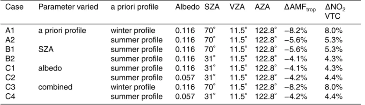
pixels can no longer be resolved by the input data sets used in the retrievals which are traditionally obtained from coarse global climatologies and models. To illustrate this problem, Fig. 1 shows the OMI overpass over central Europe on 3 January 2006 10
together with the outlines of two input parameter grids used in the Dutch OMI NO2 (DOMINO) retrieval (Boersma et al., 2008b).
Our prime motivation for this study was to obtain reliable NO2 column estimates
over Switzerland. In Switzerland as well as in most other countries in Europe, NO2 is one of the key air pollutants and despite significant reductions since the late 1980s 15
due to the introduction of exhaust after-treatment for stack emissions, 3-way catalysts and other measures, its concentrations are still frequently exceeding the air quality limits. This is particularly true for the heavily industrialized and densely populated Po Valley in Northern Italy which is one of the most polluted places in Europe and which affects air quality in southern Switzerland. The Swiss plateau and the Po Valley 20
are thus our principal areas of interest. Both are located in the vicinity of the Alps (see Fig. 1) which creates additional challenges to the retrieval. Surface pressure (or elevation) is a retrieval parameter that in principle could be estimated accurately. However, to ensure consistency between a priori NO2 profiles and surface pressure,
the latter is typically obtained from the same coarse resolution data set. Schaub et 25
AMTD
2, 781–824, 2009Improved tropospheric NO2 retrieval for satellite
observations
Y. Zhou et al.
Title Page
Abstract Introduction
Conclusions References
Tables Figures
◭ ◮
◭ ◮
Back Close
Full Screen / Esc
Printer-friendly Version
Interactive Discussion
In this paper we extend on the study of Schaub et al. (2007) and present a simple approach for a more accurate treatment of the surface topography which preserves consistency with the coarse resolution a priori NO2 profiles. This is a first step
to-wards a more accurate NO2retrieval tailored to Central Europe for which we intend to replace all input parameters by higher resolution data sets. The effect of inaccurate 5
surface pressures is quantified by reprocessing extended time periods with accurate pixel-average surface pressures and comparing original and enhanced retrieval for dif-ferent seasons separately. A sensitivity study is performed to investigate the depen-dence of the topography-related error on other forward model parameters including a priori profile shape, surface albedo, solar zenith angle (SZA) and cloud parameters. 10
Finally, to demonstrate the potential improvement of this approach, NO2 columns from the original and enhanced retrieval are compared with ground-based in situ ob-servations over the Swiss plateau (station Taenikon) and selected stations in the Po Valley in Italy where the effects of inaccurate surface pressure are the largest.
Despite our focus on the Alpine domain, the method proposed here will be applicable 15
to any other region of the globe with complex topography and can easily be transferred to other retrieval algorithms.
2 Data and methods
2.1 OMI tropospheric NO2observations
The Dutch-Finnish OMI instrument onboard the Earth Observing System (EOS) Aura 20
satellite launched in 2004 offers greatly enhanced spatial and temporal (daily global coverage) resolution as compared to its predecessors. The Aura satellite (Schoeberl et al., 2006) passes over the equator in a sun-synchronous ascending polar orbit at 13:45 local time. The NO2 vertical columns studied in this work are basically
calcu-lated in the same way as the DOMINO (Dutch OMI NO2) product data version 1.0.2
25
Ser-AMTD
2, 781–824, 2009Improved tropospheric NO2 retrieval for satellite
observations
Y. Zhou et al.
Title Page
Abstract Introduction
Conclusions References
Tables Figures
◭ ◮
◭ ◮
Back Close
Full Screen / Esc
Printer-friendly Version
Interactive Discussion
vice, www.temis.nl). Deviations will be detailed in Sect. 2.2. Data is available since October 2004. As opposed to the Dutch near-real time product, DOMINO is a more accurate post-processing data set based on a more complete set of OMI orbits, im-proved Level 1B (ir)radiance data (collection 3, Dobber et al., 2008), analyzed meteo-rological fields rather than forecast data, and actual spacecraft data (Boersma et al., 5
2007). These improvements make DOMINO the recommended product for scientific use (Boersma et al., 2008b). The improved instrument calibration parameters used in collection 3 lead to much lower across-track variability, or stripes, in the OMI NO2
products and therefore no de-striping is applied. Another important change from ear-lier versions is that the surface albedo is now based on the Koelemeijer et al. (2003) 10
database. Detailed descriptions of the algorithm for the DOMINO data product are given in Boersma et al. (2007, 2008b, 2009).
The starting point in this study is the tropospheric slant columns (SCDtrop) obtained
from the measured slant columns by subtraction of the stratospheric slant columns. In the DOMINO retrieval the stratospheric slant columns are obtained with a data-15
assimilation approach using the TM4 global chemistry transport model (Dentener et al., 2003). The vertical tropospheric column (VTC) is then derived by dividing SCDtrop by the tropospheric air mass factor (AMFtrop).
AMFtrop depends on the a priori trace gas profilexa and a set of forward model
pa-rameters ˆbincluding cloud parameters (cloud fraction, cloud pressure), surface albedo, 20
surface pressure and viewing geometry. For small optical thickness, the altitude depen-dence of the measurement sensitivity to the atmospheric species of interest (calculated with a radiative transfer model) can be decoupled from the shape of the vertical trace gas profile (calculated e.g. with an atmospheric chemistry transport model). AMFtrop
can then be written as follows (Palmer, 2001): 25
AMFtrop= P
lml( ˆb)xa,l
P
lxa,l
(1)
AMTD
2, 781–824, 2009Improved tropospheric NO2 retrieval for satellite
observations
Y. Zhou et al.
Title Page
Abstract Introduction
Conclusions References
Tables Figures
◭ ◮
◭ ◮
Back Close
Full Screen / Esc
Printer-friendly Version
Interactive Discussion
mass factorsml are calculated with a pseudo-spherical version of the DAK radiative transfer model (Stammes, 2001; de Haan et al., 1987). For computational efficiency, a lookup-table with precalculated box air mass factors at discrete points of the forward model parameters is used, and the values for a given set of parameters are obtained by linear interpolation.
5
The a priori NO2 profilexa (molecules cm− 2
) for every location is obtained from the TM4 model. The profiles are collocated daily with a model output at overpass time of the satellite. The TM4 model version used for DOMINO has a horizontal resolution of 2◦latitude by 3◦ longitude and 34 terrain-following hybrid layers extending from the
surface to 0.38 hPa. The layers are defined by two sets of hybrid level coefficients a
10
andb:
pb,l =a(l)+pTM4·b(l)
pt,l =a(l +1)+pTM4·b(l +1) (2)
wherepb,l andpt,lare the bottom and top pressure of layerl (l=1...34), andpTM4is the
TM4 model surface pressure, which equals to the bottom pressure of layer one (since 15
a(1)=0 and b(1)=1). The mid pressure of each layer is defined as the mean ofpb,l
andpt,l. Over marked topography,pTM4may strongly deviate from the effective
pixel-average surface pressure (denotedpeff in the following) due to the coarse resolution of
the TM4 model data, which is responsible for the systematic retrieval errors discussed in this study.
20
In Sect. 3.3 we will show that these errors are particularly important for cloudy scenes. The AMF for a partly cloudy scene is determined with the independent pixel approach (Boersma et al., 2007), which assumes that the air mass factor can be written as a linear combination of a cloudy and a clear sky air mass factor:
AMFtrop=wAMFcloud(pc)+(1−w)AMFclear(ps) (3)
25
where AMFcloud is the AMF for a completely cloudy pixel, and AMFclear the AMF for
AMTD
2, 781–824, 2009Improved tropospheric NO2 retrieval for satellite
observations
Y. Zhou et al.
Title Page
Abstract Introduction
Conclusions References
Tables Figures
◭ ◮
◭ ◮
Back Close
Full Screen / Esc
Printer-friendly Version
Interactive Discussion
viewing scene,ps is the surface pressure. The AMFcloud is obtained with Eq. (1) with
ml=0 for all layers below cloud. The cloud radiance fractionwis defined as
w= fclIcl
fclIcl +(1−fcl)Icr
(4)
wherefcl is the OMI effective cloud fraction, andIcl andIcrare the radiances for cloudy and clear scenes, respectively. Icl mainly depends on the viewing geometry and the
5
assumed cloud albedo (Koelemeijer et al., 2001) andIcr depends on surface albedo and viewing geometry. The cloud fraction and cloud-top heights are retrieved from the VIS-channel using the O2-O2absorption features at 477 nm (Acarreta et al., 2004).
2.2 Retrieval with effective pixel-average surface pressures
To calculate more accurate effective pixel-average surface pressures, the topography 10
height from the global digital elevation model GTOPO30 available on a high resolution (∼1×1 km2) was averaged over each OMI pixel. The resulting effective terrain height
heffof each pixel was converted to an effective surface pressurepeffbased on the TM4
surface temperature Tsurf, surface pressure pTM4 and topography height hTM4
avail-able in the DOMINO product. The conversion follows the hypsometric equation and 15
the assumption that temperature changes linearly with height, which is often used for reducing measured surface pressures to sea level (Wallace and Hobbs, 1977).
peff=pTM4×
T
surf
(Tsurf+ Γ(hTM4−heff))
−g/RΓ
(5)
whereR=287 J kg−1K−1 is the gas constant for dry air,
Γ=6.5 K km−1 the lapse rate,
andg=9.8 m s−2the acceleration by gravity.
20
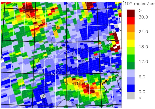
The absolute difference between effective and TM4 terrain height∆h=heff−hTM4 is
AMTD
2, 781–824, 2009Improved tropospheric NO2 retrieval for satellite
observations
Y. Zhou et al.
Title Page
Abstract Introduction
Conclusions References
Tables Figures
◭ ◮
◭ ◮
Back Close
Full Screen / Esc
Printer-friendly Version
Interactive Discussion
mountains near the border between Switzerland, France and Italy. Conversely, there is an overestimation in the surrounding areas of up to 500 m over the Swiss plateau and more than 700 m over the Po Valley in Italy.
With the other forward model parameters kept the same as in the DOMINO product, the AMFtrop and NO2 VTC was first calculated for the TM4 surface pressure pTM4,
5
and then recalculated for the effective surface pressurepeff for all the pixels within the
domain of interest (latitude between 44◦N and 52◦N, longitude between 5◦E and 12◦E)
from January 2006 to May 2008. The retrieval withpTM4 in principle reproduces the
DOMINO product. However, to obtain more accurate results we found it necessary to recompute the lookup-table of box air mass factors with additional levels of the forward 10
model parameter “surface pressure”. We increased the number of surface pressure levels from 10 to 17, allowing for more accurate interpolation in the lower troposphere. Furthermore we eliminated a problem in the calculation of box air mass factors close to the surface: for any given pressure the algorithm interpolates the box AMF between the values at the two neighboring pressure levels of the lookup table, but the lower 15
level may be located below the surface. In that case the box AMF at the lower level was assigned an unphysical value of zero, which resulted in a too low interpolated box AMF. This is an additional improvement that will be implemented in future versions of the DOMINO product. Thus, it should be kept in mind that even our product retrieved withpTM4is not identical to the DOMINO data set.
20
For the retrieval withpeffthe a priori NO2profiles had to be rescaled vertically to be
consistent with peff. This scaling is performed in a way that preserves mixing ratios
rather than subcolumns:
xa,leff =xa,l×(
peb,lff −pet,lff
pb,l −pt,l
) (6)
wherexea,lff andxa,l are the a priori NO2profile withpeffandpTM4respectively. p eff b,l and
25
pet,lff are obtained following Eq. (2) withpeff replacingpTM4in the formula. An example
AMTD
2, 781–824, 2009Improved tropospheric NO2 retrieval for satellite
observations
Y. Zhou et al.
Title Page
Abstract Introduction
Conclusions References
Tables Figures
◭ ◮
◭ ◮
Back Close
Full Screen / Esc
Printer-friendly Version
Interactive Discussion
3 Results and discussion
3.1 Monthly mean and annual cycle
The relative change in retrieved NO2 VTC defined as (VTCeff−VTCTM4)/VTCTM4 was
calculated for all snow-free (surface albedo<0.6) clear sky OMI pixels. Corresponding monthly mean maps are plotted exemplarily for December and June 2006 in Figs. 3 5
and 4, respectively, and for two different thresholds for the cloud radiance fraction of 50% (a), and 10% (b). Observations over snow were eliminated because for these pixels it is known that the contrast between cloud and the surface is too low to make a proper distinction between the two, leading to an incorrect effective cloud fraction (King et al., 1992), and therefore an ill-determined cloud pressure and less reliable retrieval. 10
Comparing the relative change in retrieved NO2 VTCs in Figs. 3 and 4 to ∆h in
Fig. 2 shows that for negative∆h(heff<hTM4, e.g. over the Swiss Plateau and the Po
Valley) NO2VTCs are underestimated when retrieved with TM4 surface pressure while
for positive∆h(heff>hTM4, e.g. over the Alps) the columns are overestimated by more
than 20% near the highest mountain ranges. Since NO2 is generally low over the
15
mountain regions and the retrieval is more uncertain due to the complex topography and snow, we focus on the more polluted areas over the planes. Comparing Figs. 3 and 4 further suggests that the relative changes in NO2 VTCs are depending on season. For example, NO2VTCs are underestimated by more than 25% over some places in the
Po Valley in December whereas in June the differences do not exceed 15%. Another 20
interesting finding is that there is an obvious difference in the results for the different cloud radiance fraction criteria. For areas with negative∆h, a 50% threshold results in more serious underestimation of NO2VTCs than a 10% threshold, and this difference
is much more obvious in December than in June. The large sensitivity of the results to the selected threshold implies that the relative change in NO2 VTCs is particularly
25
AMTD
2, 781–824, 2009Improved tropospheric NO2 retrieval for satellite
observations
Y. Zhou et al.
Title Page
Abstract Introduction
Conclusions References
Tables Figures
◭ ◮
◭ ◮
Back Close
Full Screen / Esc
Printer-friendly Version
Interactive Discussion
For illustration of the seasonal differences, two small areas were selected over the Swiss Plateau and the Po Valley (labels A and B in Fig. 2), respectively. The averaged
∆hof the selected areas are about 400 and 700 m, respectively, corresponding to a difference of about 45 hPa and 80 hPa between pTM4 and peff. Figures 5 and 6 show
the time series of monthly averaged NO2 VTCs from January 2006 to May 2009 for
5
all pixels centered in areas A and B, respectively, retrieved withpTM4 (black solid line
with square symbols) andpeff (black dashed line with diamonds). Winter months have
much higher NO2 VTCs than summer months due to the increased lifetime of NO2
(Schaub et al., 2007) and reduced vertical mixing. At the same time, both the absolute (black solid lines with crosses) and relative changes in NO2 VTCs (grey lines) exhibit
10
a seasonal cycle with higher values in winter months. However, the seasonal cycle of the changes does not necessarily align with the seasonal cycle of NO2VTCs itself. For
pixels with a cloud radiance fraction lower than 50% the underestimation of NO2VTCs
reaches values larger than 20% in both areas in some winter months (Figs. 5a, 6a). The changes in NO2VTCs are generally smaller over the Swiss Plateau than over the
15
Po Valley consistent with the smaller altitude shift. In summer, the relative change is typically of the order of 5% and the absolute change is rather small due to the much lower NO2VTCs. With a cloud radiance fraction threshold of 10%, the changes in NO2
VTCs have a much less pronounced seasonal cycle for both areas (Figs. 5b, 6b). The cause of this difference will be discussed in Sect. 3.3.
20
3.2 Sensitivity analysis for cloud free pixels
According to Eq. (1) the AMFtrop is entirely determined by the profile of the altitude
dependent box air mass factors ml and by the a priori NO2 profile shape obtained
from the TM4 model. The effect of a surface pressure change on these profiles is illustrated in Figs. 7 and 8 for the two selected pixels separately. Comparing Fig. 7a 25
AMTD
2, 781–824, 2009Improved tropospheric NO2 retrieval for satellite
observations
Y. Zhou et al.
Title Page
Abstract Introduction
Conclusions References
Tables Figures
◭ ◮
◭ ◮
Back Close
Full Screen / Esc
Printer-friendly Version
Interactive Discussion
viewing zenith angle (VZA) (Palmer, 2001). The trends of the two profiles are similar with decreasingml towards the ground, which represents the decreasing sensitivity of
the satellite instrument towards the surface due to increased scattering of light above the level of interest.
For a systematic analysis of the influence of the different retrieval parameters on the 5
topography-related NO2error, two sets of forward parameters and a priori NO2profiles
corresponding to the two pixels on 4 August and 1 December 2006 were selected to represent typical summer and winter conditions over the Po valley, respectively. The individual effects of the a priori NO2profile, SZA, and albedo as well as their combined
effects were then investigated by systematically replacing each parameter by its value 10
of the opposing season. The corresponding retrieval parameter settings are listed in Table 1, and the results are shown in Fig. 9. The TM4 surface pressure was assumed to be 928 hPa in all cases as a reference point and the effective surface pressurepeff
was varied about this point within reasonable limits thereby shifting up or down the profiles of box air mass factors and a priori profiles as described in Sect. 2.2. In the Po 15
Valley, the differences between peff and pTM4 are of the order of 80 hPa. The relative
changes in AMFtropand NO2VTCs for this specific point on the sensitivity lines in Fig. 9 are summarized in Table 1.
The shape of the a priori NO2profile is an important factor in determining the AMFtrop
(see Eq. 1). Due to the poor spatial resolution of the TM4 model the a priori NO2 20
profile varies only slowly in space such that our selected profile is representative for large parts of the Po Valley. As seen in Fig. 8, the selected winter profile exhibits a pronounced peak in the boundary layer since vertical mixing is generally weak in winter, and both the lifetime of NOx and the emissions are enhanced in this season
(Richter et al., 2002; Jaegl ´e et al., 2005). In contrast, the selected summer profile 25
shows a much lower NO2abundance near the ground resulting from enhanced vertical mixing and a reduced lifetime. Figure 9a shows how the sensitivities of the AMFtropand
NO2VTCs to varying surface pressure change when replacing the winter profile by the
AMTD
2, 781–824, 2009Improved tropospheric NO2 retrieval for satellite
observations
Y. Zhou et al.
Title Page
Abstract Introduction
Conclusions References
Tables Figures
◭ ◮
◭ ◮
Back Close
Full Screen / Esc
Printer-friendly Version
Interactive Discussion
the more pronounced a priori NO2 profile in winter results in a stronger sensitivity of the retrieved NO2 VTCs to errors in the assumed surface pressure in agreement with
the findings of Schaub et al. (2007). This is understandable since changes in surface pressure most strongly affect the box air mass factorsml at the lowest levels, and this
effect is amplified in the computation of AMFtrop if the a priori profile predicts most of
5
the NO2at these levels.
The solar zenith angle is another parameter changing strongly with season. For the selected location in the Po valley the SZA varies from 31◦ on 4 August to 70◦ on
1 December. Results for these two SZA are presented in Fig. 9b. For the larger SZA in winter, the relative changes in AMFtropand NO2VTCs are more sensitive to differences 10
betweenpTM4 andpeff than for the smaller angles in summer. This effect thus adds to
the differences observed between winter and summer.
Finally, the albedo is another parameter potentially changing with season. For the selected location the albedo varies quite strongly from 0.057 on 4 August to 0.116 on 1 December. In Fig. 9c, surprisingly and in contrast to the two previous parameters, 15
even though the largely different albedos in winter and summer seem to have a signif-icant effect on the absolute values of AMFtrop, they have a negligible influence on the sensitivity of relative changes in AMFtropand NO2VTCs to changing surface pressure,
given the retrieval parameter settings in Table 1.
Figure 9d illustrates the combined effect of the three parameters above. For the se-20
lected location in the Po valley, wherepTM4is 928 hPa andpeffis 1008 hPa, the relative
NO2VTCs change for cloud-free pixels is about 8% in winter and 4% in summer. The
sensitivity of the retrieval error to the surface pressure error is thus almost twice as large in winter as in summer which is mainly a consequence of the differences in a priori profile shape and SZA as described above. The other forward model parameters 25
AMTD
2, 781–824, 2009Improved tropospheric NO2 retrieval for satellite
observations
Y. Zhou et al.
Title Page
Abstract Introduction
Conclusions References
Tables Figures
◭ ◮
◭ ◮
Back Close
Full Screen / Esc
Printer-friendly Version
Interactive Discussion
3.3 Sensitivity analysis for cloudy pixels
To illustrate the effect of the inaccurate topography for partly cloudy pixels, we took the same forward model parameters as for the cloud-free pixel presented in Fig. 7b but assumed a cloud fraction of 15% and a cloud top pressure of 900 hPa. The profile of box AMFs of the completely cloudy part is shown in Fig. 10a, and the corresponding 5
profile of the partly cloudy pixel in Fig. 10b, which is the weighted sum of the values in Fig. 7b and Fig. 10a. Clouds are modeled as opaque Lambertian reflectors with an albedo of 0.8 (Acarreta et al., 2004). The sensitivity is enhanced above the bright cloud but drops to zero below the top of the opaque cloud as seen in Fig. 10a. The box AMF corresponding to the pressure just larger than the cloud top pressure (903 hPa) 10
behaves like a transition point, since the cloud is located within this layer, and the fraction of the layer above the cloud still has non-zeroml. This sudden change in ml
is also reflected in the profile of effective box AMFs of the partly cloudy pixel shown in Fig. 10b. Below cloud top the box AMFs drop to values much smaller than for the cloud free case in Fig. 7b.
15
AMFtropis determined by theml of the partly cloudy pixel and the a priori NO2profile
according to Eq. (1). Figures 3 and 4 suggest that the AMFtrop is generally more
sensitive to the change in terrain height for cloudy pixels than for cloud free pixels. The reason for this is illustrated in Fig. 11 showing the situation for a partly cloudy pixel and a low level cloud. Shifting the surface to a lower effective pixel altitude (right hand 20
part of Fig. 11), e.g. over the Po Valley, results in more levels becoming poorly visible to the satellite (as expressed by the rapid drop ofml below cloud top) and effectively
places a larger fraction of the polluted part of the NO2profile below the cloud (red line
in Fig. 11b). This results in a much lower AMFtrop and correspondingly higher NO2
VTC. 25
The sensitivity to the surface pressure change depends on cloud top pressure and the a priori NO2profile shape. To demonstrate this the relative changes in AMFtropand
AMTD
2, 781–824, 2009Improved tropospheric NO2 retrieval for satellite
observations
Y. Zhou et al.
Title Page
Abstract Introduction
Conclusions References
Tables Figures
◭ ◮
◭ ◮
Back Close
Full Screen / Esc
Printer-friendly Version
Interactive Discussion
different cloud pressures for the winter pixel (retrieval parameters as in case A1 in Ta-ble 1). The NO2VTC retrieved withpeff=1008 hPa instead ofpTM4=928 hPa is close to
40% higher when the cloud is located close to the surface (cloud pressure=900 hPa), which is a much larger change than for the cloud free situation. However, when the cloud is higher at 850 hPa the increase is only about 10%. Interestingly, the very high 5
sensitivity to surface pressure only occurs over a range of about 50 hPa below cloud top, which corresponds to the depth of the boundary layer with elevated NO2in Fig. 8b.
Thus, for a cloud top located inside the polluted boundary layer the retrieval error due to inaccurate surface pressure is large, especially in the winter season with pronounced NO2in the boundary layer. Conversely, when the cloud top is located above the
bound-10
ary layer, the retrieval error is comparatively small and similar to the cloud free case. Low clouds were frequently observed over some areas in the Po Valley during win-ter. For example, the monthly mean cloud pressure over area B in Fig. 2 was 917 hPa in December 2006, which contrasts with a much lower pressure of 789 hPa in June 2006. The predominance of low clouds likely explains the very high relative changes in 15
retrieved NO2VTCs in December 2006 over some areas in Fig. 3a.
4 Validation
4.1 Calculation of tropospheric NO2VTCs from ground-based measurements
In-situ ground-based measurements of NO2 for the period January 2006 to
Decem-ber 2007 were obtained from two sources, from the Swiss National Air Pollution 20
Monitoring Network (NABEL) (http://www.bafu.admin.ch/luft/00612/00625/index.html) for stations over the Swiss plateau, and from the Lombardy Regional Agency for En-vironmental Protection (ARPA), Italy, for stations in the Po Valley/Milano area (http: //www.ambiente.regione.lombardia.it). From a total of more than 100 stations only 35 were selected for the validation. All the selected stations are background stations not 25
AMTD
2, 781–824, 2009Improved tropospheric NO2 retrieval for satellite
observations
Y. Zhou et al.
Title Page
Abstract Introduction
Conclusions References
Tables Figures
◭ ◮
◭ ◮
Back Close
Full Screen / Esc
Printer-friendly Version
Interactive Discussion
more than 80% at the time of the OMI overpass during the analysis period. At these stations, nitrogen oxides are measured using commercial instruments with molybde-num converters. NO2 is catalytically converted to NO on a heated molybdenum
sur-face, and then measured as NO by chemiluminescence after reaction with ozone. It is well known that these converters are sensitive not only to NO2but also to other odd
ni-5
trogen species such as PAN, HNO3 and organic nitrates (Winer et al., 1974; Grosjean
and Harrison, 1985; Steinbacher et al., 2007). Nevertheless, it is the standard method applied in air quality monitoring networks. In a similar study using the Lombardy sta-tion network for validasta-tion of GOME observasta-tions, Ord ´o ˜nez et al. (2006) quantified the interference in the molybdenum converter at GOME overpass time following the ap-10
proach of Schaub et al. (2006), based on simultaneous measurements of surface NO2 performed with a photolytic converter (selective for NO2only) and a molybdenum
con-verter at the rural site Taenikon (47.47◦N, 8.90◦E, 539 m above sea level), Switzerland,
during the period 1995–2001. The ratios of the monthly medians of these two mea-surements on sunny days (photolytic divided by molybdenum) at GOME overpass time 15
(∼10:30 local time) were then used as factors to correct the molybdenum converter
measurements. As a first approximation, we followed the same approach yet quanti-fying the interference at the overpass time of OMI instead of GOME. The calculated monthly correction factors are shown in Table 2. The ratios show a clear seasonal cycle with a summertime minimum. This is expected since during the warm season 20
the photochemistry leads to a higher production of oxidized nitrogen species such as
HNO3 and PAN which results in a more pronounced overestimation of the NO2
sur-face concentrations by the molybdenum measurements. The ratios at OMI overpass time differ by less than 5% from those of Ord ´o ˜nez et al. (2006) at GOME overpass time from October to January but are about 10% lower in the other months due to the 25
more pronounced diurnal cycles of the interference with a larger overestimation of NO2 concentrations in the afternoon than in the morning (Steinbacher et al., 2007).
AMTD
2, 781–824, 2009Improved tropospheric NO2 retrieval for satellite
observations
Y. Zhou et al.
Title Page
Abstract Introduction
Conclusions References
Tables Figures
◭ ◮
◭ ◮
Back Close
Full Screen / Esc
Printer-friendly Version
Interactive Discussion
the refined correction method proposed by Steinbacher et al. (2007) which models the ratios by a multiple linear regression approach using daily O3 mixing ratios as a proxy
for photochemical activity and month as a factor variable to estimate the seasonal vari-ation. We used the same regression coefficients as Steinbacher et al. (2007) which are based on an analysis of the same Taenikon data used by Ordo ˜nez et al. (2006). 5
We then corrected the NO2measurements for each station separately using the ozone
data of the respective station if available. For 7 out of 35 stations no ozone measure-ments were available and therefore the monthly median ratios based on Taenikon mea-surements in Table 2 had to be used. For comparison, Table 2 also lists the monthly median correction factors deduced from the regression approach for the 28 stations 10
with O3measurements. The regression based median ratios are slightly smaller (up to
−6.3%) in winter, but are significantly higher in the other seasons compared to Taenikon
monthly median ratios with a maximal relative difference as high as 58.4% in August. The reason for this is that the Po valley stations tend to be more polluted and closer to the pollution sources than the station Taenikon and therefore the interferences from 15
higher oxidized NOyspecies tend to be smaller.
Hourly NO2measurements averaged over 13:00–14:00 local time were used for the
comparison with the NO2VTCs measured from OMI at about 13:30 LT. Only
measure-ments coincident with a valid OMI observation (see selection criteria below) and only days with a surface NO2mixing ratio larger than 1 ppb were considered since the in-20
strument detection limit for NO2is approximately 1 ppb (NABEL, 2007). For quantitative
comparison with the satellite observations, corrected NO2 mixing ratios measured at
the surface were scaled to NO2VTCs using the same TM4 vertical NO2profiles used also as a priori. These profiles are representative for the time and location of each OMI observation. The “ground based in-situ NO2VTCs” were calculated according to:
25
VTCG=VTCTM4
STM4
×SG (7)
where S represents the surface level mixing ratio and subscript G denotes ground
AMTD
2, 781–824, 2009Improved tropospheric NO2 retrieval for satellite
observations
Y. Zhou et al.
Title Page
Abstract Introduction
Conclusions References
Tables Figures
◭ ◮
◭ ◮
Back Close
Full Screen / Esc
Printer-friendly Version
Interactive Discussion
from the surface to the tropopause level. STM4is the NO2 mixing ratio of the model at
the lowest level. For comparison with the OMI NO2 VTCs retrieved with pTM4, the
original TM4 profile was used. For comparison with the OMI NO2 VTCs retrieved with
peff,however, the profile scaled to the effective surface pressure following Eq. (6) was
used. 5
The selection of OMI pixels was based on the following criteria: (1) pixel center within 10 km of the station and east-west extension of the pixel of less than 70 km, (2) cloud radiance fraction lower than 50%, (3) albedo smaller than 0.6 to exclude snow cover. If there was more than one pixel meeting the criteria on the same day then the OMI pixel with the smallest effective cloud fraction was selected. The thresholds for these 10
criteria were set to balance data quality with a sufficient number of measurements for good statistics.
4.2 Comparison of in situ and OMI tropospheric NO2VTCs
Figure 13 shows the correlation coefficients (r2) between in-situ and OMI NO2 VTCs
retrieved withpeff. For most of the stations, the in-situ NO2 VTCs are well correlated
15
with the satellite observations, with r2 ranging from 0.3 to 0.7 for, on average, 180 data points per station. Poorer correlations are observed for a few elevated stations in the pre-Alps. Due to enhanced spatial variability, both the representativeness of the surface measurement and our approach of surface measurement correction become more uncertain for these stations.
20
The measurement sites are classified by land use type as rural, suburban and ur-ban. The medians of the ratios at each station between monthly means of the OMI and in-situ NO2VTCs are shown in Fig. 14 for each station type separately. For urban
sta-tions, the ratios are closer to unity in all four seasons compared to rural and suburban stations. In Boersma et al. (2009), good agreement between OMI and in situ measure-25
AMTD
2, 781–824, 2009Improved tropospheric NO2 retrieval for satellite
observations
Y. Zhou et al.
Title Page
Abstract Introduction
Conclusions References
Tables Figures
◭ ◮
◭ ◮
Back Close
Full Screen / Esc
Printer-friendly Version
Interactive Discussion
where the retrieval withpTM4 underestimates NO2VTCs. For rural and suburban
sta-tions, the ratios exhibit a pronounced seasonal variation with highest ratios in spring months suggesting a significant overestimation of the OMI NO2 VTCs in this season.
It is important to note, however, that in these cases the absolute values and also the absolute differences between OMI and in-situ NO2 VTCs are small, with an average
5
absolute overestimation of 4.3 and 3.4 (1015molecules cm−2) for rural and suburban
stations respectively. Lamsal et al. (2008) reported similar differences between OMI and in situ measurements over North American with strongest overestimation in sum-mer. They concluded that the larger seasonal bias at rural sites suggests an incomplete removal of stratospheric NO2which has a larger relative effect where tropospheric NO2
10
columns are lower. However, different from Lamsal et al. (2008), the ratios are higher than one in most of the seasons for rural and suburban stations in our study, which may be explained by the use of different OMI NO2 products (standard product from NASA
versus our modified DOMINO product). As suggested by Bucsela et al. (2008), the NASA and KNMI algorithms produce significantly different tropospheric NO2 amounts
15
mainly due to the different retrieval parameters used.
Two examples of the comparison between OMI and in-situ NO2 VTCs at individual stations are shown in Fig. 15 for the rural station Motta (45.29◦N, 9◦E) and the urban
station Pavia (45.19◦N, 9.16◦E). The OMI VTCs follow the seasonal variation of the in
situ VTC data very well, but the OMI columns tend to be too high at the rural station 20
Motta in all months, and to be too low at the urban station Pavia in winter and fall. A weighted least squares orthogonal regression was performed for each station which considers the uncertainties in both measurements and minimizes the distances in both y- and x-direction by a chi-square minimization procedure (Press et al., 1992). The uncertainties of the OMI NO2VTCs were taken to be the estimates of the tropospheric
25
column error as provided in the DOMINO product following the approach of Boersma et al. (2004). For the majority of the OMI pixels, this uncertainty ranges from 30% to 60% of the NO2VTCs. The uncertainties of the in-situ NO2VTCs were computed as
represen-AMTD
2, 781–824, 2009Improved tropospheric NO2 retrieval for satellite
observations
Y. Zhou et al.
Title Page
Abstract Introduction
Conclusions References
Tables Figures
◭ ◮
◭ ◮
Back Close
Full Screen / Esc
Printer-friendly Version
Interactive Discussion
tativeness uncertainty, which depends on how well the TM4 NO2 vertical profile used in calculating the in-situ NO2 column represents the real NO2profile at the location of
the station, and also how well the station NO2represents the NO2abundance over the
whole extent of an OMI pixel. This uncertainty is assumed to be 20% of the in-situ NO2 VTCs. (2) The uncertainty due to the in situ measurement error, which is estimated as 5
the sum of the instrument detection limit (1 ppb) and a measurement accuracy of 10% of the NO2mixing ratio (NABEL, 2007). The uncertainty of the in situ NO2is converted to a column uncertainty using Eq. (7). For both stations the slope of the regression line is closer to one when retrieved withpeff implying a better agreement between in situ
and OMI VTCs. For the station Pavia this is clearly a result of the better agreement of 10
OMI NO2columns retrieved withpeff in winter and fall. It is interesting to see that both
the slope andr2for the rural station Motta are improved withpeff while the
correspond-ing monthly mean OMI VTCs tend to be more strongly overestimated. In summary, it may be concluded that the amplitude of the seasonal variations of NO2VTCs over the
Po Valley and the Swiss Plateau is better captured with our enhanced retrieval due to 15
the increases in autumn and winter while the problem of overestimation of the lowest columns in spring and summer remains.
5 Conclusions
An improved NO2retrieval for satellite observations over mountainous terrain was pre-sented and applied to more than two years of OMI observations over the Alpine region 20
and the adjacent planes. The method eliminates topography-related biases caused by the use of too coarse surface pressure (or altitude) data in operational retrievals. Accu-rate pixel-average surface pressures were calculated by correcting the original values with information from a high resolution topography model. A priori NO2 profiles used
in the retrieval were then scaled to the new surface pressures and tropospheric AMFs 25
and NO2 VTCs were recomputed using a modified version of the DOMINO retrieval
AMTD
2, 781–824, 2009Improved tropospheric NO2 retrieval for satellite
observations
Y. Zhou et al.
Title Page
Abstract Introduction
Conclusions References
Tables Figures
◭ ◮
◭ ◮
Back Close
Full Screen / Esc
Printer-friendly Version
Interactive Discussion
The comparison between original and enhanced retrieval indicates that the original coarse surface pressure data set lead to a significant overestimation of NO2VTCs over the Alps and an underestimation over the adjacent planes. For clear sky observations with a threshold for the cloud radiance fraction of 50% the original retrieval is about 25% too low in winter and about 5% in summer over the Po Valley and the Swiss Plateau. 5
However, these errors are much smaller when a more stringent threshold for the cloud radiance fracton of 10% is applied, which reduces the data set to essentially cloud-free pixels.
In a previous study we reported on larger topography-related errors of the order of 13–38% for cloud free pixels over the Swiss plateau (Schaub et al., 2007). However, 10
these results were based on a few selected cases only and were affected by a problem in the retrieval algorithm (see Sect. 2.2) which resulted in too low box air mass factors close to the ground and therefore a too large sensitivity to surface pressure changes.
The strong dependence of our results on the chosen cloud radiance threshold sug-gests that the AMFs calculated for the cloudy part of the pixels are more sensitive to 15
errors in surface pressure than the AMFs of the clear part. This was confirmed by a detailed analysis for a partly cloudy pixel which further revealed that this sensitivity is particularly large when the cloud top is located inside the polluted boundary layer.
To examine the reason for the pronounced seasonal differences of our results we per-formed a systematic sensitivity analysis of the dependence of the topography-related 20
error on those retrieval parameters potentially changing with season. For cloud free pixels, the seasonal differences in the a priori NO2 profile shape was found to be the
dominating factor explaining a major fraction of the different sensitivities to the surface pressure error between winter and summer. Differences in SZA were also found to be important while changes in albedo had no significant effect. Overall, the sensitivity of 25
the retrieval error to the surface pressure error is almost twice as large in winter as in summer.
AMTD
2, 781–824, 2009Improved tropospheric NO2 retrieval for satellite
observations
Y. Zhou et al.
Title Page
Abstract Introduction
Conclusions References
Tables Figures
◭ ◮
◭ ◮
Back Close
Full Screen / Esc
Printer-friendly Version
Interactive Discussion
VTCs deduced from ground-based in situ measurements. Our validation focused on 35 selected stations over the Swiss plateau (station Taenikon) and the Po Valley in Italy where the effects of inaccurate surface pressure are the largest. Only background sta-tions in urban, suburban and rural environments were selected as they are less affected by nearby sources and are therefore expected to be representative for their respective 5
environment. The in-situ NO2 measurements were corrected for known interferences
from higher oxidized nitrogen species such as PAN and HNO3using ozone as a proxy for photochemical activity as proposed by Steinbacher et al. (2006). Corrected NO2
mixing ratios were then scaled to NO2VTCs using NO2 vertical profiles from the TM4
model. With the accurate surface pressure data set, in-situ and OMI NO2VTCs exhibit 10
a significant correlation (r2=0.3–0.7) for most stations. A particularly good agreement between OMI and in situ measurements in terms of both correlation and absolute val-ues was found for urban background stations in the Po valley. Our new retrieval further improves the agreement for both urban and suburban stations by partially correcting the underestimation of NO2VTCs retrieved withpTM4, which is serious in winter. Since
15
in winter and fall there exist lowest uncertainties in the correction factors applied to the in situ measurements, we are most confident with this improvement. However, for rural and suburban stations, the ratios between OMI and in-situ NO2 VTCs exhibit an
obvious seasonal variation with highest values close to 2 in spring months. Taking the uncertainties of each data point of both measurements into consideration in the regres-20
AMTD
2, 781–824, 2009Improved tropospheric NO2 retrieval for satellite
observations
Y. Zhou et al.
Title Page
Abstract Introduction
Conclusions References
Tables Figures
◭ ◮
◭ ◮
Back Close
Full Screen / Esc
Printer-friendly Version
Interactive Discussion
Acknowledgements. This work was supported by the Swiss Federal Office for the Environment
(FOEN). We thank Piet Stammes and Johan de Haan for developing the DAK radiative trans-fer model and allowing us to utilize it for AMF calculations. Many thanks to the OMI team at KNMI for developing the NO2retrieval within the DOMINO project and for making available the data through the ESA project TEMIS. We acknowledge Christoph H ¨uglin, Empa, for
provid-5
ing NO2 and ozone measurements from the Swiss National Air Pollution Monitoring Network (NABEL) and Enrica Zenoni for corresponding data from the Regional Agency for Environmen-tal Protection (ARPA) of Lombardy, IEnvironmen-taly. The authors would like to thank Carlos Ord ´o ˜nez and Martin Steinbacher for useful discussions and for their assistance in the validation study.
References 10
Acarreta, J. R., De Haan, J. F., and Stammes, P.: Cloud pressure retrieval us-ing the O2−O2absorption band at 477 nm, J. Geophys. Res., 109, D05204, doi:10.1029/2003JD003915, 2004.
Bertram, T. H., Heckel, A., Richter, A., Burrows, J. P., and Cohen, R. C.: Satellite mea-surements of daily variations in soil NOx emissions, Geophys. Res. Lett., 32(24), L24812
15
doi:10.1029/2005GL024640, 2005.
Blond, N., Boersma, K. F., Eskes, H. J., van der A, R. J., Van Roozendael, M., De Smedt, I., Bergametti, G., and Vautard, R.: Intercomparison of SCIAMACHY nitrogen dioxide ob-servations, in-situ measurements and air quality modeling results over Western Europe, J. Geophys. Res., 112, D10311, doi:10.1029/2006JD007277, 2007.
20
Boersma, K. F., Eskes, H. J., and Brinksma, E. J.: Error analysis for tropospheric NO2retrieval from space, J. Geophys. Res., 109, D04311, doi:10.1029/2003JD003962, 2004.
Boersma, K. F., Eskes, H. J., Veefkind, J. P., Brinksma, E. J., van der A, R. J., Sneep, M., van den Oord, G. H. J., Levelt, P. F., Stammes, P., Gleason, J. F., and Bucsela, E. J.: Near-real time retrieval of tropospheric NO2from OMI, Atmos. Chem. Phys., 7, 2103–2118, 2007,
25
http://www.atmos-chem-phys.net/7/2103/2007/.
Boersma, K. F., Jacob, D. J., Bucsela, E. J., Perring, A. E., Dirksen, R., van der A, R.J., Yan-tosca, R.M., Park, R.J., Wenig, M., Bertram, T. H., and Cohen, R. C.: Validation of OMI tropospheric NO2observations during INTEX-B and application to constrain NOxemissions over the eastern United States and Mexico, Atmos. Environ., 42, 4480–4497, 2008a.
AMTD
2, 781–824, 2009Improved tropospheric NO2 retrieval for satellite
observations
Y. Zhou et al.
Title Page
Abstract Introduction
Conclusions References
Tables Figures
◭ ◮
◭ ◮
Back Close
Full Screen / Esc
Printer-friendly Version
Interactive Discussion
Boersma, K. F., Dirksen, R., Veefkind, J. P., Eskes, H. J., and van der A, R. J.: Dutch OMI NO2 (DOMINO) data product HE5 data file user manual, TEMIS website, http://www.temis. nl/airpollution/no2.html, 2008b.
Boersma, K. F., Jacob, D. J., Trainic, M., Rudich, Y., DeSmedt, I., Dirksen, R., and Eskes, H. J.: Validation of urban NO2 concentrations and their diurnal and seasonal variations observed
5
from space (SCIAMACHY and OMI sensors) using in situ measurements in Israeli cities, Atmos. Chem. Phys. Discuss., 9, 4301–4333, 2009,
http://www.atmos-chem-phys-discuss.net/9/4301/2009/.
Bovensmann, H., Burrows, J. P., Buchwitz, M., Frerick, J., No ¨el, S., and Rozanov, V.V.: SCIA-MACHY: Mission objectives and measurement modes, J. Atmos. Sci., 56, 2, 127–150, 1999.
10
Bucsela, E. J., Celarier, E. A., Wenig, M. O., Gleason, J. F., Veefkind, J. P., Boersma, K. F., and Brinksma, E. J.: Algorithm for NO2vertical column retrieval from the Ozone Monitoring Instru-ment, IEEE Trans. Geosci. Rem. Sens., 44, 1245–1258, doi:10.1109/TGRS.2005.863715, 2006.
Bucsela, E. J., Perring, A. E., Cohen, R. C., et al.: Comparison of tropospheric NO2 in situ
15
aircraft measurements with near-real-time and standard product data from the Ozone Moni-toring Instrument, J. Geophys. Res., 113, D16S31, doi:10.1029/2007JD008838, 2008. Burrows, J. P., Weber, M., Buchwitz, M., Rozanov, V., Ladst ¨atter-Weissenmayer, A., Richter, A.,
DeBeek, R., Hoogen, R., Bramstedt, K., Eichmann, K. U., Eisinger, M., and Perner, D.: The global ozone monitoring experiment (GOME): Mission concept and first scientific results, J.
20
Atmos. Sci., 56, 151–175, 1999.
Callies, J., Corpaccioli, E., Eisinger, M., Hahne, A., and Lefebvre, A.: GOME-2: Metop’s second generation sensor for operational ozone monitoring, ESA Bull., 102, 28–36, 2000.
De Haan, J. F., Bosma, P. B., and Hovenier, J. W.: The adding method for multiple scattering computations of polarized light, Astron. Astrophys, 183, 371–391, 1987.
25
Dentener, F., van Weele, M., Krol, M., Houweling, S., and van Velthoven, P.: Trends and inter-annual variability of methane emissions derived from 1979–1993 global CTM simulations, Atmos. Chem. Phys., 3, 73–88, 2003,
http://www.atmos-chem-phys.net/3/73/2003/.
Dobber, M., Kleipool, Q., Dirksen, R., Levelt, P., Jaross, G., Taylor, S., Kelly, T., Flynn, L.,
30
Leppelmeier, G., and Rozemeijer, N.: Validation of Ozone Monitoring Instrument level-1b data products, J. Geophys. Res., 113, D15S06, doi:10.1029/2007JD008665, 2008.
AMTD
2, 781–824, 2009Improved tropospheric NO2 retrieval for satellite
observations
Y. Zhou et al.
Title Page
Abstract Introduction
Conclusions References
Tables Figures
◭ ◮
◭ ◮
Back Close
Full Screen / Esc
Printer-friendly Version
Interactive Discussion
Experiments and Applications, Academic Press, San Diego, CA, 2000.
Grosjean, D. and Harrison, J.: Response of chemiluminescence NOxanalyzers and ultraviolet ozone analyzers to organic air pollutants, Environ. Sci. Technol., 19, 862–865, 1985. Jaegl ´e, L., Steinberger, L., Martin, R. V., and Chance, K.: Global partitioning of NOx sources
using satellite observations: Relative roles of fossil fuel combustion, biomass burning and
5
soil emissions, Faraday Discuss., 130, 407–423, 2005.
King, M. D., Kaufman, Y. J., Menzel, W. P., and Tanr ´e, D.: Remote sensing of cloud, aerosol and water vapor properties from the Moderate Resolution Imaging Spectrometer (MODIS), IEEE Trans. Geosci. Remote Sens., 30, 2–27, 1992.
Koelemeijer, R. B. A., Stammes, P., Hovenier, J. W., and de Haan, J. F.: A fast method for
10
retrieval of cloud parameters using oxygen A-band measurements from Global Ozone Mon-itoring Experiment, J. Geophys. Res., 106, 3475–3490, 2001.
Koelemeijer, R. B. A., de Haan, J. F., and Stammes, P.: A database of spectral surface reflec-tivity in the range 335–772 nm derived from 5.5 years of GOME observations, J. Geophys. Res., 108, 4070, doi:10.1029/2002JD002429, 2003.
15
Lamsal, L. N., Martin, R. V., van Donkelaar, A., et al.: Ground-level nitrogen dioxide concentra-tions inferred from the satellite-borne Ozone Monitoring Instrument, J. Geophys. Res., 113, D16308, doi:10.1029/2007JD009235, 2008.
Levelt, P. F., van den Oord, G. H. J., Dobber, M. R., M ¨alkki, A., Visser, H., de Vries, J., Stammes, P., Lundell, J. O. V., and Saari, H.: The Ozone Monitoring Instrument, IEEE Trans. Geosci.
20
Rem. Sens., 44, 1093–1101, doi:10.1109/TGRS.2006.872333, 2006a.
Levelt, P. F., Hilsenrath, E., Leppelmeier, G. W., van den Oord, G. H. J., Bhartia, P. K., Tamminen, J., de Haan, J. F., and Veefkind, J. P.: Science Objectives of the Ozone Monitoring Instrument, IEEE Trans. Geosci. Rem. Sens., 44, 1199–1208, doi:10.1109/TGRS.2006.872336, 2006b.
25
Martin, R. V., Jacob, D. J., Chance, K. V., Kurosu, T. P., Palmer, P. I., and Evans, M. J.: Global inventory of Nitrogen Dioxide Emissions Constrained by Space-based Observations of NO2 Columns, J. Geophys. Res., 108, 4537, doi:10.1029/2003/JD003453, 2003.
Martin, R. V., Parrish, D. D., Ryerson, T. B., et al.: Evaluation of GOME satellite measure-ments of tropospheric NO2 and HCHO using regional data from aircraft campaigns in the
30
southeastern United States, J. Geophys. Res., 109, D24307, doi:10.1029/2004JD004869, 2004.
AMTD
2, 781–824, 2009Improved tropospheric NO2 retrieval for satellite
observations
Y. Zhou et al.
Title Page
Abstract Introduction
Conclusions References
Tables Figures
◭ ◮
◭ ◮
Back Close
Full Screen / Esc
Printer-friendly Version
Interactive Discussion
nitrogen oxide emissions with regional aircraft measurements over and downwind of eastern North America, J. Geophys. Res., 111, D15308, doi:10.1029/2005JD006680, 2006.
NABEL: Technischer Bericht zum Nationalen Beobachtungsnetz f ¨ur Luftfremdstoffe, Empa, D ¨ubendorf, Switzerland, 2007.
Nolin, A., Armstrong, R., and Maslanik, J.: Near-real time SSM/I EASE grid daily global ice
5
concentration and snow extent, Digital Media, National Snow and Ice Data Center, Boulder, CO, USA, 2005.
Ord ´o ˜nez, C., Richter, A., Steinbacher, M., Zellweger, C., N ¨uß, H., J., Burrows, P., and Pr ´ev ˆot, A. S. H.: Comparison of 7 years of satellite-borne and ground-based tropospheric NO2 mea-surements around Milan, Italy, J. Geophys. Res., 111, D05310, doi:10.1029/2005JD006305,
10
2006.
Palmer, P. I., Jacob, D. J., Chance, K., Martin, R. V., Spurr, R. J. D., Kurosu, T. P., Bey, I., Yan-tosca, R., Fiore, A., and Li, Q.: Air mass factor formulation for spectroscopic measurements from satellites: Application to formaldehyde retrievals from the Global Ozone Monitoring Ex-periment, J. Geophys. Res., 106, 14539–14550, 2001.
15
Platt, U.: Differential Optical Absorption Spectroscopy (DOAS), in: Air monitoring by Spectro-scopic Techniques, edited by: Sigrist, M. W., Chemical Analysis, 127, 27–76, 1994.
Press, W. H., Flannery, B. P., Teukolsky. S. A., and Vetterling, W. T.: Numerical recipes: The art of Scientific Computing, Cambridge Univ. Press, New York, 1992.
Richter, A. and Burrows, J. P.: Tropospheric NO2from GOME measurements, Adv. Space Res.,
20
29, 1673–1683, 2002.
Schaub, D., Boersma, K. F., Kaiser, J. W., Weiss, A. K., Folini, D., Eskes, H. J., and Buch-mann, B.: Comparison of GOME tropospheric NO2columns with NO2profiles deduced from ground-based in situ measurements, Atmos. Chem. Phys., 6, 3211–3229, 2006,
http://www.atmos-chem-phys.net/6/3211/2006/.
25
Schaub, D., Brunner, D., Boersma, K. F., Keller, J., Folini, D., Buchmann, B., Berresheim, H., and Staehelin, J.: SCIAMACHY tropospheric NO2 over Switzerland: estimates of NOx lifetimes and impact of the complex Alpine topography on the retrieval, Atmos. Chem. Phys., 7, 5971–5987, 2007,
http://www.atmos-chem-phys.net/7/5971/2007/.
30
Schoeberl, M. R., Douglass, A. R., Hilsenrath, E., et al.: Overview of the EOS aura mission, IEEE Trans. Geosci. Remote Sens., 44, 1066–1074, 2006.
AMTD
2, 781–824, 2009Improved tropospheric NO2 retrieval for satellite
observations
Y. Zhou et al.
Title Page
Abstract Introduction
Conclusions References
Tables Figures
◭ ◮
◭ ◮
Back Close
Full Screen / Esc
Printer-friendly Version
Interactive Discussion
climate change, John Wiley & Sons, New York, 1998.
Stammes, P.: Spectral radiance modeling in the UV-Visible range, IRS2000: in: Current prob-lems in atmospheric radiation, edited by: Smith, W. L. and Timofeyev, Y. J., A. Deepak, Hampton, Va, USA, 385–388, 2001.
Steinbacher, M., Zellweger, C., Schwarzenbach, B., Bugmann, S., Buchmann, B., Ord ´o ˜nez,
5
C., Prevot, A. S. H., and Hueglin, C.: Nitrogen oxides measurements at rural sites in Switzerland: Bias of conventional measurement techniques, J. Geophys. Res., D11307, doi:10.1029/2006JD007971, 2007.
Vandaele, A. C., Fayt, C., Hendrick, F., et al.: An intercomparison campaign of ground-based UV-visible measurements of NO2, BrO, and OClO slant columns: Methods of analysis and
10
results for NO2, J. Geophys. Res., 110, D08305, doi:10.1029/2004JD005423, 2005.
van der A, R. J., Peters, D. H. M. U., Eskes, H., Boersma, K. F., van Roozendael, M., de Smedt, I., and Kelder, H. M.: Detection of the trend and seasonal variation in tropospheric NO2over China, J. Geophys. Res., 111, D12317, doi:10.1029/2005JD006594, 2006.
van der A, R. J., Eskes, H. J., Boersma, K. F., van Noije, T. P. C., van Roozendael, M., de
15
Smedt, I., Peters, D. H. M. U., and Meijer, E. W.: Trends, seasonal variability and dominant NOxsource derived from a ten year record of NO2measured from space, J. Geophys. Res., 113, D04302, doi:10.1029/2007JD009021, 2008.
Wallace, J. M. and Hobbs, P. V.: Atmosphere science, an introductory survey, Academic Press, California, USA, 1977.
20
Wang, Y. X., McElroy, M. B., Boersma, K. F., Eske, H. J., and Veefkind, J. P.: Traffic Restric-tions Associated with the Sino-African Summit: ReducRestric-tions of NOx Detected from Space, Geophys. Res. Lett., 34, L08814, doi:10.1029/2007GL029326, 2007.
Winer, A. M., Peters, J. W., Smith, J. P., and Pitts Jr., J. N.: Response of commercial chemilumi-nescent NO-NO2analyzers to other nitrogen containing compounds, Environ. Sci. Technol.,
25
AMTD
2, 781–824, 2009Improved tropospheric NO2 retrieval for satellite
observations
Y. Zhou et al.
Title Page Abstract Introduction Conclusions References Tables Figures ◭ ◮ ◭ ◮ Back Close
Full Screen / Esc
Printer-friendly Version
Interactive Discussion Table 1.Retrieval parameter settings in the case studies of retrieval parameter effects on
sensi-tivity of relative changes in AMFtrop(∆AMFtrop) and NO2VTC (∆NO2VTC) respect to change in surface pressure, and the results of selected surface pressure (reference pointpTM4=928 hPa, peff=1008 hPa).
Case Parameter varied a priori profile Albedo SZA VZA AZA ∆AMFtrop ∆NO2 VTC
A1 A2
a priori profile winter profile summer profile 0.116 0.116 70◦ 70◦ 11.5◦ 11.5◦ 122.8◦
122.8◦ −
8.2% −5.6% 8.0% 5.3% B1 B2
SZA summer profile summer profile 0.116 0.116 70◦ 31◦ 11.5◦ 11.5◦ 122.8◦ 122.8◦ −5.6% −4.1% 5.3% 4.3% C1 C2
albedo summer profile summer profile 0.116 0.057 31◦ 31◦ 11.5◦ 11.5◦ 122.8◦
122.8◦ −
4.1% −4.2% 4.3% 4.4% C3 C4
combined winter profile summer profile 0.116 0.057 70◦ 31◦ 11.5◦ 11.5◦ 122.8◦
122.8◦ −
8.2%
−4.2%
AMTD
2, 781–824, 2009Improved tropospheric NO2 retrieval for satellite
observations
Y. Zhou et al.
Title Page
Abstract Introduction
Conclusions References
Tables Figures
◭ ◮
◭ ◮
Back Close
Full Screen / Esc
Printer-friendly Version
Interactive Discussion Table 2. Monthly medians of the ratio of NO2 measurements performed with photolytic and
molybdenum converters at Taenikon, Switzerland, under clear-sky conditions (sunshine frac-tion of at least 0.8) from 13:00 to 14:00 local time during the period January 1995 to mid-August 2001 (applied for the 7 stations without ozone measurements). The second column shows monthly medians of the correction factors (mean corrected NO2 divided by mean measured NO2 for each station) based on regression analysis of the 28 stations with ozone measure-ments. The relative differences between the two median ratios ((regression ratio-Taenikon ratio)/Taenikon ratio) are also shown.
Month Median ratio Median ratio Relative difference (Taenikon) (Regression) (%)
January 0.850 0.822 −3.3
February 0.774 0.726 −6.3
March 0.667 0.696 4.4
April 0.537 0.653 21.6
May 0.463 0.669 44.6
June 0.488 0.668 36.9
July 0.466 0.722 54.9
August 0.517 0.819 58.4
September 0.647 0.856 32.3
October 0.767 0.866 12.9
November 0.806 0.870 7.9