A MEDIAN-BASED DEPTHMAP FUSION STRATEGY FOR THE GENERATION OF
ORIENTED POINTS
M. Rothermela∗, N. Haalab, D. Fritschb a
nFrames GmbH, Stuttgart, Germany - [email protected] bInstitute of Photogrammetry, Stuttgart University, Germany
KEY WORDS:Matching, Surface, Three-dimensional, Point Cloud, Fusion, Triangulation
ABSTRACT:
Due to good scalability, systems for image-based dense surface reconstruction often employ stereo or multi-baseline stereo methods. These types of algorithms represent the scene by a set of depth or disparity maps which eventually have to be fused to extract a consistent, non-redundant surface representation. Generally the single depth observations across the maps possess variances in quality. Within the fusion process not only preservation of precision and detail but also density and robustness with respect to outliers are desirable. Being prune to outliers, in this article we propose a local median-based algorithm for the fusion of depth maps eventually representing the scene as a set of oriented points. Paying respect to scalability, points induced by each of the available depth maps are streamed to cubic tiles which then can be filtered in parallel. Arguing that the triangulation uncertainty is larger in the direction of image rays we define these rays as the main filter direction. Within an additional strategy we define the surface normals as the principle direction for median filtering/integration. The presented approach is straight-forward to implement since employing standard oc- and kd-tree structures enhanced by nearest neighbor queries optimized for cylindrical neighborhoods. We show that the presented method in combination with the MVS (Rothermel et al., 2012) produces surfaces comparable to the results of the Middlebury MVS benchmark and favorably compares to an state-of-the-art algorithm employing the Fountain dataset (Strecha et al., 2008). Moreover, we demonstrate its capability of depth map fusion for city scale reconstructions derived from large frame airborne imagery.
1. INTRODUCTION
3D surface reconstruction from large sets of overlapping imagery has been, and still is, a vivid research topic in photogrammetry and computer vision especially for complex 3D scenes. Driven by advances in digital camera technology and algorithms, lim-its of automatic image-based 3D data capture were pushed re-garding precision, robustness, processing speed and scale. In this work we focus on the problem of depth map fusion for a wide range of applications, including datasets in the domain of large scale airborne mapping. Traditionally aerial imagery is cap-tured in nadir viewing directions enabling reconstruction of 2.5-dimensional (2.5D) Digital Surface Models (DSM). Such DSMs provide detailed roof structures, however reconstructed geome-try at facades is limited. While this is sufficient for applications aiming at LOD1 and LOD2 city representations, explicit geomet-ric information on facade elements like doors and windows as well as other vertical objects is frequently required. Since such features are difficult to extract from nadir flights, oblique camera systems operated by unmanned aerial vehicles (UAV) or aircraft are becoming more and more important. Algorithms for depth map fusion derived from such imagery require to properly han-dle 3D geometry, scale well to the amount of collected data, offer precise reconstructions at high density and guarantee adequate run times.
A tremendous amount of research was conducted in the area of image-based surface reconstruction in the last three decades. For an excellent overview and probably the most popular benchmark of multi view stereo (MVS) systems see (Seitz et al., 2006). Sev-eral approaches represent the scene to be reconstructed in ob-ject space from an early stage. Typical representatives include level set methods (Pons et al., 2007) and mesh evolution algo-rithms (Hiep et al., 2009). Patch-based algoalgo-rithms like (Furukawa
∗Corresponding author
and Ponce, 2010) start with high confident surface points and grow the surface utilizing geometric information of the points al-ready reconstructed. Space carving (Kutulakos and Seitz, 1998) starts with a solid and iteratively carves the volumetric entities not being photo-consistent across the views. Scene representa-tion based on 2.5D height fields deliver good results for the re-construction of elevation data or DSMs, for example (Vogiatzis et al., 2008), (Bethmann and Luhmann, 2015). For these methods, shape priors in the course of matching can be conveniently for-mulated due to the regular structure of raster representations. In contrast to object space based methods, depth map based match-ing algorithms represent the surface information by a set of 2D distance or disparity maps. This type of matching methods is quite popular for large scale reconstructions since naturally di-viding the problem of reconstruction into multiple subproblems. More precisely, geometry is reconstructed by matching one or a limited set of neighboring views to a reference view using stereo or multi-baseline stereo (e.g. (Okutomi and Kanade, 1993) (Mer-rell et al., 2007), (Goesele et al., 2007), (Pollefeys et al., 1998). These methods in general produce depth maps which hold redun-dant surface observations. In order to extract a consistent repre-sentation of the scene, depth maps have to be fused eventually.
T
ile-wise fusion
Normal computation
Support ltering
Str
eaming to T
iles
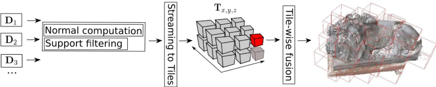
Figure 1: Flow chart of the proposed fusion algorithm. Depth imagesDiare sequentially filtered and point-wise normals are computed.
On completion of each image, points and corresponding normals and image ids are streamed to 3D cubes regularly partitioning object space. The single cubes are then subject to the fusion process.
redundant triangles are removed from the boundaries of single patches and remainders are connected. In (Merrell et al., 2007) an approach for real-time fusion of noisy depth maps was pre-sented. Thereby, proximate depth maps are rendered into one reference view, redundant depths are pixel-wise checked for ge-ometric consistency and are eventually filtered using occlusion and confidence checks. After averaging consistent depths a mesh is constructed in image space using quadtrees and lifted to 3D space. In contrast to the latter two local methods, global methods extract surfaces by minimizing a global energy functional typi-cally forcing visibility constraints or smoothness whilst possibly representing input data to a high degree. Global methods tend to deliver more robust results, however, this comes at the cost of less scalability and higher computational costs. An example produc-ing watertight surface meshes was proposed by (Kazhdan et al., 2006), (Kazhdan and Hoppe, 2013). The algorithm operates on oriented point sets and models the surface as an indicator function evaluating to1behind the surface and0in front of the surface. At the in-front / behind transition the gradient of the vector field is maximal. Oriented points, i.e. 3D coordinates along correspond-ing normals, are considered as samples of the indicator functions gradient and are used to construct a gradient vector field. The in-dicator function is given by the function minimizing the absolute difference between vector field and the indicator functions gradi-ent. This then can be casted as a Poisson problem, which can be efficiently solved.
A large portion of depth map fusion methods build up on volu-metric range integration (VRIP) (Curless and Levoy, 1996). Typ-ically a signed distance field is computed on a (multi-level) oc-tree structure by the projection of depth estimations from which then a triangulation can be derived, for example using the March-ing Cube algorithm (Lorensen and Cline, 1987). UsMarch-ing the same base concept, (Zach et al., 2007) reconstruct a signed distance field in voxel space. Then a surface is extracted by minimizing a global energy functional based on TV-L1 regularization, claim-ing smoothness and small differences to the zero level set. Em-ploying the L1 norm yields favorably results in the presence of outliers. However, depth samples across views possessing dif-ferent scales is challenging for VRIP approaches. One example addressing this issue is the scale space representation presented in (Fuhrmann and Goesele, 2011). They build a multi-level oc-tree holding vertices at different scales. Vertices are sorted to the octree structure according to their pixel footprint. This way a hierarchical signed distance field is generated. For iso-surface extraction the most detailed surface representation is preferred. Similarly, (Kuhn et al., 2014) proposed a method employing vari-able voxel sizes defined by observation-wise precision estimates. These precision measures are computed for each disparity based on TV in the disparity maps. The local TV is associated with an error class defining quality which is previously learned using ground truth.
In this work we present a local method for depth map fusion. Similar to (Fuhrmann and Goesele, 2011) we first assign points to an multi-level octree structure according to the pixel footprint. Subsequent filter operations are then carried out on points of the locally lowest tree-levels, whereas high level points are discarded. This way not only local surface sampling is adapted, but also most precise samples can be identified. Moreover, for each point the id of the reference image (Rothermel et al., 2012) and its nor-mal is stored. The latter is derived in image space employing an adaptive, discontinuity preserving triangulation on each depth map based on a RQT (Pajarola, 1998). Due to the triangulating character of MVS, precisions along image rays are expected to be smaller than precisions perpendicular to the rays. When filter-ing sfilter-ingle points, we acknowledge this fact by only incorporatfilter-ing points located in a cylinder oriented in direction of the largest uncertainty, e.g the line of sight. Within a second strategy we fil-ter along the point-wise normals. Approaches employing the L1 norm yield excellent results since outliers possess small influence on integration process. Our method is based on the idea to further restrict the impact of outliers by employing median filtering. The methodology is discussed in detail in section 2. While we mainly use close range data sets to evaluate our concept, additional re-sults in section 3 demonstrate the feasibility of our approach for 3D reconstructions in complex urban areas from oblique aerial images as the aspired main area of application.
2. METHODOLOGY
2.1 Pipeline Overview
In this section we discuss the single modules of the proposed fu-sion algorithm. The flow chart of the complete workflow is de-picted in figure 1. The input is a set of oriented depth images Di, for which the respective camera parameters, i.e. exterior and
Figure 2: Visualization for the criterion assigning points to the octree. Circles mark the point-wise GSD, points represent the coordinates. Points are assigned to the box they are located in and the side lengths of the box are comparable to the GSD.
and streamed, along its normals and image ID, to its correspond-ing cube. The points contained by each cube are then subject to a fusion/filter algorithm. Thereby, within a first step point-wise pixel footprints and the vector defined by the ray connecting point and camera center are computed. Then the actual filtering is per-formed. This involves identification of the points representing the surface with the best precision and subsequent median filter-ing along the point-wise lines of sight or normals (section 2.2). Beside scalability, cube-wise processing offers the possibility of convenient high-level parallelization.
2.2 Median-based Fusion
Motivated by the results obtained by the median-based fusion al-gorithms for 2.5 surface representations, as for example imple-mented in (Hirschm¨uller, 2008), (Rothermel et al., 2014a), we propose a median-based fusion strategy for 3D scenes. The gen-eral idea is to first extract the set of surface pointsP mapping the object with the highest resolution. This not only recovers the smallest sampling rates of images observing the surface, but also, if image scale is assumed to define precision, recovers the most accurate points. Then, each pointp∈ Pis incorporated into the process of median filtering along the vector defined by its transla-tion to the camera center. The motivatransla-tion for filtering along these rays is based on the fact that precision along the line of sight and perpendicular to these lines are not identical due to properties of forward intersection which in general delivers lower accuracies in viewing directions. The aforementioned algorithms for 2.5D DSM integration define the main filter direction by the normal of the predominant plane fitting the observed surface. Obviously such a plane does not exist for 3D scenes. Therefore, within a second approach we define the main filter direction by the point-wise normals. Since its minor importance to the algorithmic dis-cussion, in the following section we denote both, lines of sight as well as normals, bynand refer to them aspoint-wise filter direction(PFD).
Derivation of the Most Precise Point Set Representing the Surface In this section we explain how we extract the point set P representing the most precise surface samples assuming the pixel footprint represents reconstruction quality. Therefore we use a multi-scale octree structure into which all points of a single tile are inserted. Point coordinates and the point-wise pixel foot-print define the octree cell an observation is located in. Points located on the lowest level (leaf nodes) of the octree then indicate the most precise surface sample.
Octrees are data structures separating space by regular boxes. Each of the cubes contains 8 daughter cubes regularly subdi-viding its mother cube. Points to be inserted are assigned to cubes (nodes) if certain criteria are fulfilled. For example, a
Figure 3: Left: Evaluation of the criterion describing if an octree box contains any points inside a specified cylinderp,np,hf(p),
rf(p). Conditions are based on the coordinatesc′x,c ′
y,c
′ zof box
centerc′defined w.r.t. the coordinate systemΦ. Right: Median filtering along the main filter directionnp. Translations induced
by candidatesq∈ Qare given by their projection on the cylinder axisnp.
point is assigned to the smallest box fully containing a sphere around the respective point coordinates. Hence, the octree struc-ture implements an ordering scheme of points providing queries for point location as well as neighborhood queries. Our imple-mentation follows the algorithms proposed by (Gargantini, 1982), (Press et al., 2007). For tree traversal, the link between mother nodes and daughter nodes have to be provided. Instead of a more conventional implementation where links between mother nodes and daughter nodes are realized by doubly linked pointers we prefer a implementation based on hash maps, also called Lin-ear Octrees. The main advantage is that the usage of pointers (each 64bit on common hardware) storing mother-daughter and daughter-mother relationships is avoided. This reduces memory requirements, which supports the processing of single tiles in par-allel and therefore speed up the integration process.
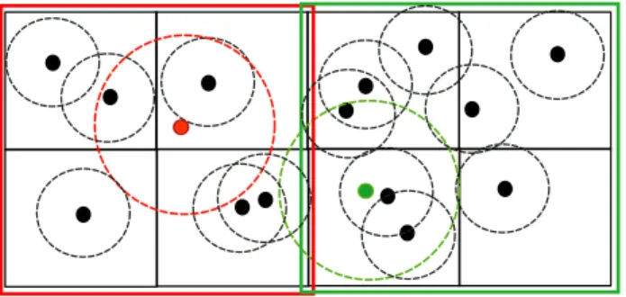
To identify the point setPwe sort all pointst∈ T contained in a single tile into the octree. LetBbe an octree box with the side lengths. As visualized in figure 2, a pointt = [tx, ty, tz]with
the footprintf(t)is located inBif the point is inside the cell and
Bis the smallest box satisfying
s > to(t) (1)
with
to(t) =αf(t) +β P
t∈T f(t)
1 +β . (2)
To be able to extenuate the influence of single footprintsto(t)is composed of the local footprint and the average pixel footprints in the tile or the whole data set. For largeβa uniform sampling can be derived neglecting scale variances across single observations completely. The parameterαcontrols the sampling density of the surface, therefore using a large valuedαthe surface is under-sampled and for a small valuedαoversampling is enforced which might be desirable for high redundant datasets.
After sorting all points of a tile to the octree the initial point set Pis derived by identifying all leaf nodes. Per leaf node one point is generated by averaging coordinates and main filter directions of all contained points. Points from higher octree levels are dis-carded. Note that within these two steps the number of points is significantly reduced, typical by a factor of 5 to 10.
registration and propagated from dense stereo, as well as proper-ties of ray intersection angles are not modeled by the pixel-wise footprints. These errors cause the extracted pointsPbeing noisy, hence we median filter the point setPalong the PFD. Thereby, all (in most cases more than one) samples stored in the all leaf nodes are incorporated by the filtering process. Note that this set of leaf node points in general is much larger thanP. Within a first step for eachp∈ P a set of neighboring points is derived from the octree. Paying respect to the lager uncertainty in main filter direction as well as to outliers, the neighbors are defined by the set of pointsQlocated in a cylinder with its central axis given bypand its PFD (np). The cylinder radius and height are
dependent of the footprint and specified byrf(p)andhf(p) re-ceptively (see figure 3 (left)). To limit smoothing and artifacts at tile borders we typically choose a rather small radiusr = 1.4. The tube height in our experiments is set toh= 15.
Identification the point setQinvolves nearest neighbor queries on the octree structure. Starting at the mother node, each octree cube is checked if itself or any daughters might contain leaf node points located in the cylinder of question. This query is checked frequently and thus has to be designed carefully. LetBbe a candi-date octree box with the centercand the side lengths. Moreover letp,np,r,hdefine the cylinder (see figure3 (left)). We
con-struct a Cartesian coordinate systemΦwith the origin inpand the z-axis pointing in direction ofnp= [nx, ny, nz]. The axes of
the coordinate system are defined by the columns of the rotation matrix
R=
r⊤1 r⊤2 r⊤ 3
=
1 1 −nx+ny nz (r1×r3)⊤
nx ny nz
(3)
The box center can then be transferred into the coordinates sys-temΦby
c′=R(c−p). (4) The octree boxBmay contain points located in the cylinder if
q
(c′x)2+ (c′y)2< r+√3s (5)
and
c′z< h. (6)
The term√3sin equation (5) represents the radius of a sphere enclosingB. If conditions (5) and (6) are not fulfilled traversal of daughter nodes is terminated. If the conditions are fulfilled and additionally the examined boxBis a leaf node all points con-tained byBare a subset ofQ.
Once the set of neighborsQis identified, allq∈ Qare checked to be located in the specified cylinder. This is done following equations (4)-(6) by exchanging roles of box centers and points. If not located in the tube, the sample is removed fromQ. Ad-ditionally for eachq ∈ Qthe angle between its normalnqand
npis computed. If this angle is larger than60◦the sample is
removed fromQand discarded for further filtering. This way the incorporation of points not representing the same surface is avoided. After removal of suspicious samples the actual filtering is performed. The basic idea of the implemented median filtering is to translate the coordinates ofpalong its PFDnp. The
trans-lation is given by the median of transtrans-lations induced byqi. More
precisely, a translation of a sampleqiwith respect toΦis given
by its projection ontonp
di(qi) = [qi−p]
⊤
np, (7)
see figure 3 (right). Then the updated coordinatesp′ are
com-Figure 4: Left: Partitioning scheme of a KD-tree. Each node con-tains one point, nodes are divided by hyperplanesgi. Direction
of planes are incremented over the dimensionDof spaceIRn (in this exampleIR2
). Right: Evaluation of the criterion describing if a KD-tree node fully contains a given cylinder. Therefore the D-th component of D-the coordinateshu(D)+rf(p),hl(D)+rf(p)
have to be completely located on one side of the planeg.
puted as
p′=p+npmedian[di(qi)]. (8)
Median Filtering - Additional Iterations The median-based integration described before enforces the setPto converge to the median surface. However, for noisy data sets multiple iterations might further improve the final surface. We found two additional iterations are a good trade-off between processing time and im-proved surface quality. Recall that within the first iteration all points contained in all leaf nodes of the octree were considered for integration. To speed up further iterations we restrict filtering on pointsp∈ P solely. As before,Phas to be sorted to a 3D data structure enabling cylinder-based neighborhood queries. An octree as presented in the last section would be suitable for this task. However, we found that for our data sets these queries can be processed faster using KD-trees.
KD-trees are structures partitioning k-dimensional points based on half spaces. Since in this work we are interested in 3D en-tities, we restrict the following discussion to 3D space. Initially the first two points to be inserted are divided by a plane perpen-dicular to the axis of the first dimension (x-axis). These spaces define the initial nodes of the tree. For a new pointpnewto be
inserted the leaf node in whichpnewis located in along with the
pointpoldalready contained by the node are identified. The node
then is further split by a plane separatingpnew andpold
lead-ing to two new leaf nodes, see figure 4 (left). The orientation of the plane is defined orthogonally to the second dimension. Sub-sequent insertions are performed in a similar way: first the leaf node, the contained point and the dimensionddefining the direc-tion of its last separadirec-tion are identified. Then, the node is divided by a plane possessing a normal in direction of the incremented dimension((d+ 1) mod 3), resulting in two new leaf nodes. For implementation details the reader is referred to the algorithm proposed in (Press et al., 2007).
In order to extract the point setQcontaining the points located in a cylinder defined by the pointp, its axisnp, its radiusrf(p)
and heighthf(p)efficient neighborhood queries have to be pro-vided. To identify the node whose daughters hold all points in the tube we identify the node fully containing the tube. Therefore we construct two pointshl =p−h2npandhu = pl+h2np,
it is evaluated if the two spheres defined byhlandhland the
radiusrf(p)are fully contained by one of the daughter nodes. Letgbe the position of the plane separating the daughter nodes in dimensionD. Then the conditions are given by
hl,u(D) +rf(p)< g (9) and
hl,u(D)−rf(p)> g. (10) If a node fulfills both conditions (9),(10) and its daughter nodes do not, the node is guaranteed to be the smallest node holding all points located in the cylinder. Once this node is identified, all points contained by the daughters are skimmed and those lo-cated in the cylinder define the setQ. Analogously to filtering in the first iteration, all inconsistent samplesqipossessing PFDs
largely differing fromnpare identified and removed fromQ. The
remainder is median filtered alongnp.
3. RESULTS
3.1 Fountain Dataset
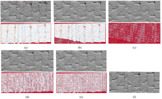
The first evaluation is carried out on the Fountain dataset (Strecha et al., 2008) for which a ground truth mesh based on LiDAR data is available. Triangles of this mesh were reprojected to the center view to generate a ground truth depth map. Using (Rothermel et al., 2012), an initial point set was obtained by matching each view to its four closest neighbors. These points then were subject to the integration algorithm employing the two filter strategies (normal and line-of-sight filtering). Thereby, the parameters of cylinder radii for oc- and kd-trees were set to our standard pa-rametersr= 1.4andh= 15. For comparison, points were also integrated by an state-of-the art algorithm proposed in (Fuhrmann and Goesele, 2011). For evaluation purposes a subpart of the gen-erated points was selected and the depths were compared to the ground truth depth map. Whereas figure 5 displays statistics of residuals, figure 6 displays the subpart of generated points which were meshed using Delaunay triangulation and the color-coded residuals. From the meshes it can be observed that line of sight filtering delivers surfaces possessing slightly less outliers. This is due to the fact that normals, and therefore the direction of cylin-ders, in areas of limited density might be erroneous. An improve-ment of sub-pixel accuracy can not be observed. Comparison of the standard deviations of residuals andσ3 filtered residuals of our method and (Fuhrmann and Goesele, 2011) clarifies that the median-based approach produces clearly less outliers. Again, re-sults ofσ3filtered residuals are rather similar. However, specify-ing the multiplier determinspecify-ing the footprint-dependent samplspecify-ing rate to four (FG-s4, figure6c), the number of outliers is decreased, but so is the point density and therefore the preservation of de-tails. The density in figure 5 denotes the size of the area induced by the filtered, projected points. Our approach delivers lower den-sities, however a loss of detail in the meshes can not be observed. Table 1 lists the processing times of the single algorithms and shows that the presented approach clearly out-performs the com-parison method.
Method ours-los ours-n FG-s4 FG-s2 FG-s1
time (min) 1.8 1.6 36 92 519
Table 1: Processing times for filtering the complete Fountain dataset of our algorithm and the method proposed in (Fuhrmann and Goesele, 2011).
0 0.2 0.4 0.6 0.8 1 1.2 1.4 1.6
[pix]
0 20 40 60 80 100
ours - los
ours - n
FG -s1
FG -s2
FG -s4 pts [%
]
density [%
]
[
pix
]
[pix
]
Figure 5: Mean differences, standard deviations and density anal-ysis for the sub-area of the fountain dataset displayed in figure 6. Comparison of our algorithms with main filter directions along lines of sight (los) and normals (n) and (Fuhrmann and Goesele, 2011) using different GSD multipliers (1,2,4).
3.2 Middlebury Dataset
(a) (b) (c)
(d) (e) (f)
Figure 6: Meshes derived from filtered point clouds and differences of reprojected points to ground truth mesh (dark blue / dark red correspond to +5 / -5 GSD). (a)-(c): Results derived by (Fuhrmann and Goesele, 2011) employing gsd-wise multipliers of 1, 2 and 4. (d) and (e): our approach with filtering along normals and in direction of line of sight. (f): ground truth.
Figure 7: Results for the Middlebury benchmark using the dino dataset.
3.3 Aerial Dataset
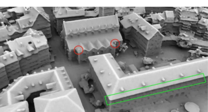
Figure 9: Mesh representation of the urban scenario. Clear edges (green rectangle) and small details as poles on the church roof (red circles) are successfully reconstructed.
Within a second test, the capability of processing large scale scenes is shown. Therefore we generated depth maps of a urban scenario using aforementioned MVS. The imagery was captured with an medium format Leica RCD30 Penta oblique system. Nadir im-agery possesses an overlap of 80% in-strip and 75% cross-strip. The oblique cameras were mounted with an angle of35◦
. The size of the average pixel footprint is 6.6 cm across the whole data set. After filtering and normal computation in image space single depths are converted to points and streamed into40meters cubes subdividing object space. The points then are tile-wise filtered by sub-sampling withα = 2andβ = 0using tube radius of two GSD. Since no ground truth is available for the data set this test is of more qualitative nature, more precisely, preservation of details, artifacts at tile borders and correctness of topology are evaluated visually. For visual inspection, a mesh was computed using a Poisson reconstruction based on oriented points gener-ated by our approach (see figure 9). As can be seen edges are extracted clearly (green rectangle) and details like the poles are reconstructed successfully. Virtually no outliers are contained in the reconstructed surface and narrow alleys are topological cor-rect. The depicted area is computed from 25 tiles. Albeit some artifacts are introduced at tile borders of oriented points, these are not visible in the mesh representation due to smoothing in the course of mesh extraction. Figure 10 depicts a reconstruction of a larger part of the urban data set.
4. CONCLUSIONS AND FUTURE WORK
In this article we presented a median-based approach for the fu-sion of depth maps. Point coordinates are sub-sampled using a multi-level octree. By sorting points to the tree, an initial point set favoring observations possessing the smallest pixel footprint is identified. Iterative median filtering of points in a cylinder along
point-wise lines of sight or normals lead to an improved set of oriented points. Within our tests concerning the filter direction, it was shown that filtering along lines of sight yields surfaces with less outliers compared to filtering along point normals. This is due do the fact that normal computation might fail in areas of limited density. However, accuracy of the derived surfaces was comparable. Moreover, compared to results derived by a state-of-the-art algorithm, our method produces less outliers, similar accuracy and superior processing times. Evaluation on the Mid-dlebury MVS benchmark showed that the implemented algorithm in combination with (Rothermel et al., 2012) and (Kazhdan et al., 2006) performs well on completeness and precision: for the temple data set 99.5% of observations possess an average devi-ation of 0.55mm to the ground truth and an average deviation of0.47mm for the dino data set, respectively. We showed that by spatially subdividing point clouds using the proposed tiling scheme the method scales well and makes the algorithm suited for reconstruction of complex urban scenes from high resolution airborne imagery. Although specifying the main filter direction along the surface normal and incorporating only limited number of neighboring points for filtering, artifacts are visible at some parts of the tile borders. Albeit being eliminated in the course of integration within the subsequent Poisson reconstruction, this problem can be eliminated by extension of single cubes using a small apron. Furthermore, a loss of detail is observed and bulges at edges are introduced during meshing. Since the oriented points are of good quality, we plan to use an algorithm for mesh ex-traction not incorporating further optimization causing additional smoothing. Moreover, re-meshing or mesh connection at tile bor-ders has to be investigated to fully enable the generation of con-sistent large-scale surface meshes.
REFERENCES
Bethmann, F. and Luhmann, T., 2015. Semi-global matching in object space. The International Archives of Photogrammetry, Re-mote Sensing and Spatial Information Sciences 40(3), pp. 23.
Curless, B. and Levoy, M., 1996. A volumetric method for build-ing complex models from range images. In: Proceedings of the 23rd annual conference on Computer graphics and interac-tive techniques, SIGGRAPH ’96, ACM, New Orleans, LA, USA, pp. 303–312.
Fuhrmann, S. and Goesele, M., 2011. Fusion of depth maps with multiple scales. In: Proceedings of the 2011 SIGGRAPH Asia Conference, SA ’11, ACM, New York, NY, USA, pp. 148:1– 148:8.
Furukawa, Y. and Ponce, J., 2010. Accurate, dense, and robust multiview stereopsis. IEEE Transactions on Pattern Analysis and Machine Intelligence 32(8), pp. 1362–1376.
Gargantini, I., 1982. An effective way to represent quadtrees. Commun. ACM 25(12), pp. 905–910.
Goesele, M., Snavely, N., Curless, B., Hoppe, H. and Seitz, S. M., 2007. Multi-view stereo for community photo collections. In: 11th International Conference on Computer Vision, 2007. ICCV 2007., IEEE, pp. 1–8.
Hiep, V. H., Keriven, R., Labatut, P. and Pons, J.-P., 2009. To-wards high-resolution large-scale multi-view stereo. In: Com-puter Vision and Pattern Recognition, 2009. CVPR 2009., IEEE, pp. 1430–1437.
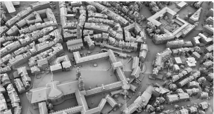
Figure 10: Larger part of the mesh generated from the airborne oblique data set. Visible tile overlaps are due to shading and not to variances in geometry.
Kazhdan, M. and Hoppe, H., 2013. Screened poisson surface reconstruction. ACM Trans. Graph. 32(3), pp. 29:1–29:13.
Kazhdan, M., Bolitho, M. and Hoppe, H., 2006. Poisson surface reconstruction. In: Proceedings of the Fourth Eurographics Sym-posium on Geometry Processing, SGP ’06, Eurographics Associ-ation, Aire-la-Ville, Switzerland, pp. 61–70.
Kuhn, A., Mayer, H., Hirschm¨uller, H. and Scharstein, D., 2014. A tv prior for high-quality local multi-view stereo reconstruc-tion. In: 3D Vision (3DV), 2014 2nd International Conference on, Vol. 1, IEEE, pp. 65–72.
Kutulakos, K. N. and Seitz, S. M., 1998. What do photographs tell us about 3d shape? Technical report, Computer Science Dept., U. Rochester.
Lorensen, W. E. and Cline, H. E., 1987. Marching cubes: A high resolution 3d surface construction algorithm. In: Proceedings of the 14th annual conference on Computer graphics and interac-tive techniques, SIGGRAPH ’87, ACM, New York, NY, USA, pp. 163–169.
Merrell, P., Akbarzadeh, A., Wang, L., Mordohai, P., Frahm, J.-M., Yang, R., Nist´er, D. and Pollefeys, J.-M., 2007. Real-time visibility-based fusion of depth maps. In: 11th International Con-ference on Computer Vision, 2007. ICCV 2007., IEEE, pp. 1–8.
Okutomi, M. and Kanade, T., 1993. A multiple-baseline stereo. Pattern Analysis and Machine Intelligence, IEEE Transactions on 15(4), pp. 353–363.
Pajarola, R., 1998. Large scale terrain visualization using the restricted quadtree triangulation. In: Visualization ’98. Proceed-ings, pp. 19–26.
Pollefeys, M., Koch, R., Vergauwen, M. and Van Gool, L., 1998. Metric 3d surface reconstruction from uncalibrated image se-quences. In: 3D Structure from Multiple Images of Large-Scale Environments, Springer, pp. 139–154.
Pons, J.-P., Keriven, R. and Faugeras, O., 2007. Multi-view stereo reconstruction and scene flow estimation with a global image-based matching score. Int. J. Comput. Vision 72(2), pp. 179–193.
Press, W. H., Teukolsky, S. A., Vetterling, W. T. and Flannery, B. P., 2007. Numerical Recipes 3rd Edition: The Art of Scientific Computing. 3 edn, Cambridge University Press, New York, NY, USA.
Rothermel, M., Bulatov, D., Haala, N. and Wenzel, K., 2014a. Fast and robust generation of semantic urban terrain models from uav video streams. In: 2014 22nd International Conference on Pattern Recognition (ICPR), IEEE, pp. 592–597.
Rothermel, M., Haala, N. and Fritsch, D., 2014b. Generating oriented pointsets from redundant depth maps using restricted quadtrees. The International Archives of Photogrammetry, Re-mote Sensing and Spatial Information Sciences 40(3), pp. 281.
Rothermel, M., Wenzel, K., Fritsch, D. and Haala, N., 2012. Sure: Photogrammetric surface reconstruction from imagery. In: Proceedings LC3D Workshop, Berlin, Vol. 8, pp. 1–9.
Seitz, S. M., Curless, B., Diebel, J., Scharstein, D. and Szeliski, R., 2006. A comparison and evaluation of multi-view stereo re-construction algorithms. In: Computer Vision and Pattern Recog-nition. CVPR 2006, pp. 519–528.
Strecha, C., von Hansen, W., Gool, L. V., Fua, P. and Thoen-nessen, U., 2008. On benchmarking camera calibration and multi-view stereo for high resolution imagery. In: Computer Vi-sion and Pattern Recognition, 2008. CVPR 2008., IEEE, pp. 1–8.
Turk, G. and Levoy, M., 1994. Zippered polygon meshes from range images. In: Proceedings of the 21st annual conference on Computer graphics and interactive techniques, SIGGRAPH ’94, ACM, New York, NY, USA, pp. 311–318.
Vogiatzis, G., Torr, P. H. S., Seitz, S. M. and Cipolla, R., 2008. Reconstructing relief surfaces. Image Vision Comput. 26(3), pp. 397–404.