Toward enhanced understanding and projections of climate extremes using physics-guided data mining techniques
Texto
Imagem

Documentos relacionados
The authors further argued that the adoption of unconventional monetary policy measures is a result of the Great Recession, as central banks understood the need to intervene
Thus, considering different scenarios for future projections, the PDSI was estimated from the data of climate projections of precipitation and soil moisture of the Coupled
Here, we investigated the potential future climate change impacts to the North Sea and the Baltic Sea ecosystem using a coherent regional downscaling strategy based on the
The surface energy balance is evaluated using SEB observations from three AWSs in the ablation and percolation zone along the K-transect and from those AWSs of the GC-net for
desempenhavam essencialmente um papel mais preponderante na questão do art. 126.º do CPEREF, onde era regulada a inibição para o exercício do comércio. Por fim, quanto à
Here we have produced a new global map of climate using the K ¨oppen- Geiger system based on a large global data set of long-term monthly precipitation and temperature station
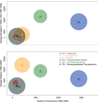
While the climate community has invested significant effort to provide downscaling techniques yielding localized information on future climate extreme behaviours, these methods do
soil map and climate data) to predict the water quantity and quality of the ungauged basin using the MapWindow version of SWAT (MWSWAT),.. • Using the Data Uncertainty Engine (DUE)
