MARIANA MÉDICE FIRME SÁ
PEDOGÊNESE, DINÂMICA TÉRMICO-HÍDRICA E EMISSÕES DE GASES DE EFEITO ESTUFA EM TOPOSEQUÊNCIA NA REGIÃO DE USHUAIA,
ARGENTINA
Tese apresentada à Universidade Federal de Viçosa, como parte das exigências do Programa de Pós-Graduação em Solos e Nutrição de Plantas, para obtenção do título de Doctor Scientiae.
VIÇOSA
MINAS GERAIS - BRASIL
MARIANA MÉDICE FIRME SÁ
PEDOGÊNESE, DINÂMICA TÉRMICO-HÍDRICA E EMISSÕES DE GASES DE EFEITO ESTUFA EM TOPOSEQUÊNCIA NA REGIÃO DE USHUAIA,
ARGENTINA
Tese apresentada à Universidade Federal de Viçosa, como parte das exigências do Programa de Pós-Graduação em Solos e Nutrição de Plantas, para obtenção do título de Doctor Scientiae.
APROVADA: 29 de agosto de 2014.
_____________________________ __________________________________
Prof. Felipe Nogueira Bello Simas Prof. Guilherme Resende Corrêa
(Coorientador)
_____________________________ __________________________________
Prof. Márcio Rocha Francelino Prof. Fabio Soares Souza
_________________________________
Prof. Carlos Ernesto G. R. Schaefer
ii
AGRADECIMENTOS
Agradeço imensamente a Deus por me dar a oportunidade, coragem e determinação para concluir o doutorado e escrever esta tese, e de alguma forma, passar o meu conhecimento. Agradeço a ele por colocar pessoas certas no meu caminho.
Agradeço por ter tido oportunidade, quando recém-chegada a Viçosa, de conhecer o professor Carlos Ernesto R. Schaefer, ele viu em mim um potencial que talvez nem eu mesma soubesse que existia. Sou grata por ele ter confiado em minha capacidade e no meu trabalho.
Não posso deixar de agradecer a minha família, em especial à minha mãe, Maria Lúcia, e ao meu pai, Luiz Alberto, que me ensinaram quase tudo que eu sei; e a correr atrás dos meus objetivos, mesmo que ninguém acreditasse neles.
Ao meu marido, Diego C. Loureiro, pelo apoio, amor e compreensão nos momentos bons e ruins. Por me tolerar quando não conseguia escrever nenhuma palavra, e por vibrar comigo no final de cada capítulo. Agradeço minhas filhas, Letícia e Joana, por tornarem meus dias mais doces...são os meus amores, são minha vida.
A todos os amigos e amigas que contribuíram de muitas formas para que esta conquista acontecesse.
Um agradecimento especial aos profs. James Bockheim, Felipe Nogueira B. Simas, Roberto Ferreira M. Michel, Márcio Rocha Francelino, Samara Salamene, Guilherme Resende Corrêa e Elpídio Inácio F. Filho, que contribuíram de diferentes maneiras para a realização este trabalho.
A CAPES, CNPq, UFV, Depart. de Solos, aos professores, laboratoristas, técnicos-administrativos do DPS, especial a Cláudia e a Luciana, sempre dispostas a nos ajudar.
iii
SUMÁRIO
RESUMO ... V
ABSTRACT ... VI
INTRODUÇÃO GERAL ... 1
REFERÊNCIASBIBLIOGÁFICAS ... 3
CAPÍTULO 1 ... 4
SOILS AT THE SOUTHRNMOST ANDEAN MOUNTAIN: PEDOGENESIS OF A TOPOSEQUENCE FROM NOTHOFAGUS FOREST TO SUB ANTARCTIC TUNDRA AT TIERRA DEL FUEGO. ... 4
ABSTRACT ... 4
1.INTRODUCTION ... 5
2.MATERIALANDMETHODS ... 7
2.1 Regional setting, environment and studied sites ... 7
2.2 Soil sampling ... 10
2.3 Physical, chemical and mineralogical analyses ... 11
3.RESULTS ... 13
3.1 General Aspects ... 13
3.2 Soil morphology and physical properties ... 14
3.3 Chemical attributes and organic matter characterization ... 18
3.4 Mineralogical results ... 21
4.DISCUSSION ... 24
4.1 Pedogenesis, Soil Classification and Soil Landscape Relationship ... 24
4.2 Pedogenetic processes ... 27
5.CONCLUSIONS ... 31
6.REFERENCES ... 32
CAPÍTULO 2 ... 37
REGIMETÉRMICOEHÍDRICODESOLOSDOMONTEMARTIAL,PATAGONIA MERIDIONAL(2011A2013). ... 37
RESUMO ... 37
1.INTRODUÇÃO ... 38
2.MATERIALEMÉTODOS ... 40
2.1 Sítios de monitoramento ... 40
2.2 Instalação, coleta e processamento dos dados ... 42
3.RESULTADOS ... 44
3.1 Sítio sob Floresta (NO) ... 44
3.2 Sítio sob Tundra (TUA) ... 47
4.DISCUSSÃO ... 51
5.CONCLUSÕES ... 58
6.REFERENCIAS BIBLIOGRÁFICAS ... 59
CAPÍTULO 3 ... 72
EMISSÕES DE CO2, CH4 E N2O EM TUNDRA E FLORESTA NOTHOFAGUS NO VALE MARTIAL – PATAGÔNIA ARGENTINA. ... 72
RESUMO ... 72
1.INTRODUÇÃO ... 73
2.MATERIALEMÉTODOS ... 75
2.1 Localização e caracterização dos sítios de coleta ... 75
iv
2.3 Experimento e coleta das emissões de CO2 do solo ... 79
2.4 Experimento e coleta das emissões de N2O e CH4 do solo ... 80
2.5 Análises estatísticas ... 82
3.RESULTADOS ... 82
3.1 Variáveis ambientais ... 82
3.1.1. Temperatura e conteúdo de água no solo durante o experimento ... 82
3.1.2 Propriedades gerais dos solos ... 84
3.2 Emissões de CO2 do solo ... 86
3.3 Emissões de CH4 do solo ... 87
3.4 Emissões de N2O do solo ... 88
4.DISCUSSÃO ... 90
4.1 Matéria orgânica e N mineral nos perfis de solo ... 90
4.2 Mineralização da matéria orgânica e emissões de CO2 ... 91
4.3 Metanogênese e emissões de CH4 ... 92
4.4 Nitrificação, desnitrificação e emissões de N2O ... 94
5.CONCLUSOES ... 97
6.REFERENCIASBIBLIOGRÁFICAS ... 98
v
RESUMO
FIRME SÁ, Mariana Médice, D.Sc., Universidade Federal de Viçosa, agosto de 2014. Pedogênese, dinâmica térmico-hídrica e emissões de gases de efeito estufa no Monte Martial, Ushuaia, Argentina. Orientador: Carlos Ernesto Gonçalves Reynaud Schaefer. Coorientador: Felipe Nogueira Bello Simas
Um estudo pioneiro sobre a pedogênese de uma topossequência no Monte Martial foi realizado, juntamente com o estudo da dinâmica térmico-hídrica, e das emissões de CO2, N2O e CH4. Os solos do Monte Martial são jovens (Inceptisols e Entisols),
pedregosos e o teor de matéria orgânica do solo é elevado, porém diminui com o aumento da altitude. Os solos apresentam semelhanças físico-químicas e mineralógicas em função da homogeneidade o material de origem sedimentar. As variações relacionadas à cobertura vegetal, à presença de material vulcânico de origem eólica (pequenos fragmentos de vidro vulcânico) e a altitude são em grande parte responsáveis pelos principais processos pedogenéticos aos quais estes solos são submetidos, tais como andosolização (solos florestais e sob Tundra), podzolização (solos florestais) e criogênese (em altitude), todos demonstrando baixo grau de desenvolvimento. Ademais, a alta latitude destes solos os confere temperaturas frias (regime isofrigid), onde o clima polar se instala em maior altitude (> 900 metros de altitude). Os solos florestais estão em ambiente mais quente, e a presença da cobertura vegetal densa funciona como uma barreira física contra o vento e a neve, o que diminui as variações térmicas mais intensas e o congelamento sazonal do solo durante o inverno. Na Tundra, os solos são mais frios, congelam superficialmente e apresentam longo período de condições isotermais. Ao mesmo tempo, os solos sob Tundra apresentam maior variação do conteúdo de água no solo, em função do degelo anual durante o verão. As emissões de gases de efeito estufa foram avaliadas em duas épocas e em 3 sítios de monitoramento, junto aos perfis, sendo um sob floresta e dois sob a Tundra. As emissões de CO2 apresentaram alta correlação
positiva com a temperatura (r>0,7), nas duas épocas. A umidade não apresentou boa correlação com nenhum dos três gases mensurados. As emissões dos três gases foram baixas em ambas as épocas, e denotam a tendência de solos com baixo nível de emissões para todos os três gases mensurados (dreno). As emissões de CO2 foram
vi
ABSTRACT
FIRME SÁ, Mariana Médice, D.Sc., Universidade Federal de Viçosa, August, 2014. Pedogenesis, thermal-hydric dynamics and emissions of greenhouse gases at Mount Martial, Ushuaia, Argentina. Adviser: Carlos Ernesto Gonçalves R. Schaefer. Co-adviser: Felipe Nogueira Simas Bello
A pioneering study on the pedogenesis with emphasis on the mineralogical characteristics of the soils of a toposequence on Mount Martial was held, along with the study of the thermal-hydraulic dynamics, and emissions of CO2, N2O and CH4. The
soils of Mount Martial are young (Inceptisols and Entisols), stony, and organic matter content is high, but decreases in altitude. The soils exhibit physicochemical and mineralogical similarities depending on the material homogeneity of sedimentary origin, except for variations related to vegetation cover, presence of volcanic material from wind turbines (small fragments of volcanic glass) and altitude, which are largely part responsible for the different pedogenic processes to which these soils are subjected, such as andosolization (under forest and tundra soils), podzolization (forest soils) and criogênese (in altitude), both showing low level of development. Moreover, these high latitude soils gives the cold temperatures (isofrigid regime), where the polar climate settles in altitude. Forested soils are warmer, and the presence of dense vegetation cover acts as a physical barrier against wind and snow, which inhibits the most intense thermal variations and seasonal soil freezing during the winter. In Tundra soils are colder, freeze superficially and have long isotermais conditions. At the same time, the Tundra soils have higher variation of water content in the soil, depending on the annual melt during the summer. Emissions of greenhouse gases were evaluated in two seasons and three monitoring sites, along with profiles, one under forest and two in the Tundra. CO2 emissions showed high positive correlation with temperature (r> 0.7) in both
seasons. The moisture did not show good correlation with any of the three measured gases. Emissions of the three gases were low in both sites, and denote the tendency of soils with low emissions for all three measured gases. CO2 emissions were higher
1
INTRODUÇÃO GERAL
Na Terra do Fogo são encontradas algumas das mais recentes áreas expostas a
pedogênese da Cordilheira dos Andes (Tromboto, 2008). A diminuição das áreas
cobertas pelo gelo têm se intensificado desde a última pequena idade do gelo (desde o
século 17) com destaque especial para as últimas décadas (Strelin e Iturraspe, 2007).
De maneira geral, os estudos prévios indicam que, com exceção de poucos
casos, a maioria das geleiras do continente sul-americano vem mostrando um recuo
generalizado (Strelin e Iturraspe, 2007). De acordo com Strelin e Iturraspe (2007),
apenas uma pequena porção da geleira Martial irá permanecer até o final do século. O
provável aumento da temperatura e da exposição do solo causará alteração no equilíbrio
da produção primária destes ambientes e nos processos relacionados ao congelamento
sazonal do solo. Além disso, problemas socioambientais em decorrência da diminuição
da vazão de água pela drenagem, visto que, muitas vezes, a água do degelo anual é uma
das únicas fontes de água doce para a população local, como é o caso da cidade de
Ushuaia, Terra do Fogo, Argentina.
De acordo com o IPCC (2007) os primeiros indícios de uma mudança climática
e ambiental serão observados inicialmente onde as temperaturas médias do ar estão
próximas a zero. Nestes locais o solo está sujeito a condições de congelamento e degelo
dependendo de um equilíbrio térmico tênue e, por isso, mais sujeito as alterações
causadas pelas mudanças climáticas e ambientais. Muitos questionamentos existem a
respeito de como serão afetados os ambientes frios da Terra do Fogo em função do
possível aumento temperatura média do ar, tanto na temperatura do solo ou cobertura de
neve, como nas emissões de gases de efeito estufa destes ambientes e nos ciclos
2
A presente tese encontra-se estruturada em três capítulos que visam,
respectivamente: i) estudar as características e a gênese dos solos numa topossequência
no Monte Martial; ii) entender a dinâmica térmica e hídrica dos solos sob Floresta e
Tundra; iii) avaliar a dinâmica do fluxo das emissões de NO2, CH4 e CO2 frente às
variações climáticas e temporais nos sítios sob Floresta de Nothofagus sp. e sob Tundra.
A área de estudo é propícia para os estudos citados acima, e representa uma
referência de ambiente natural de clima frio pouco antropisado, permitindo obter valores
de referência de gases de efeito estufa, assim como, comparar os fluxos de diferentes
coberturas vegetais e com outras regiões da Criosfera. Ademais, a alta latitude
possibilita o estudar a influência de fatores como a baixa temperatura e a cobertura de
neve, nas emissões de gases de efeito estufa (GEE’s).
A presente pesquisa representa uma ação do Projeto Terrantar, vinculado ao
INCT da Criosfera, sendo um dos primeiros trabalhos realizados na região dos Andes. O
projeto tem como objetivo aprofundar o conhecimento pedológico e sobre as mudanças
climáticas e ambientais na paisagem e solos da Antártica e dos Andes, através de
pesquisas sobre estes ambientes terrestres. Atualmente, o projeto estuda solos andinos
em diferentes países (Argentina, Colômbia, Chile, Equador e Peru).
Na Criosfera do Ártico, os solos congelados (Permafrost) têm sido considerados
potenciais fontes potenciais de GEE’s, em função dos seus elevados teores de C
orgânico (French, 2007). No Hemisfério sul, a grande maioria dos solos congelados é
pobre em C orgânico (French, 2007). Por isso, ainda não é claro qual seria o impacto de
possíveis aumentos de temperatura sobre o balanço de C e N do solo nos ecossistemas
terrestres da Criosfera Andina e Antártica (Simas et al., 2007; Vieira et al., 2010). É
3
primária da vegetação e a incorporação de C atmosférico em tais solos, permitindo que
se tornem áreas de depósito de gases de efeito estufa.
Dessa forma, o objetivo geral deste estudo visa entender de forma mais integrada
os ambientes terrestres frios e periglaciais da Terra do Fogo e quais seriam os efeitos
que as mudanças climáticas e ambientais globais poderão promover nos ambientes
terrestres subantárticos da América do Sul.
REFERÊNCIAS BIBLIOGÁFICAS
French, H., 2007. The Periglacial Environment. Wiley, Chichester, UK. 458 pp.
IPCC. 2007. Climate change 2007: The physical science basis. Summary for policymakers. Contribution of working group I to the fourth assessment report of the Intergovernmental Panel on Climate Change (IPCC). p. 1-18. In S. Solomon et al. (eds.) Cambridge University Press, Cambridge, UK.
Simas FNB, Schaefer CEGR, Melo VF, Albuquerque-Filho MR, Michel RFM, Pereira VV, Gomes MRM, Costa LM (2007) Ornithogenic cryosols from Maritime Antarctica: Phosphatization as a soil forming process. Geoderma 138, 191-203.
Strelin, J. e Iturraspe, R. Recent evolution and mass balance of Cordón Martial glaciers, Cordillera Fueguina Oriental. Global and planetary change, v. 59. p.17-26. 2007. Trombotto, D., 2008, Geocryology of Southern South America, in Rabassa, J., ed., The late Cenozoic of Patagonia and Tierra del Fuego, Volume 11: Developments in Quaternary Sciences: Amsterdam; Boston [Mass.]; Oxford, UK, Elsevier.
4
CAPÍTULO 1
SOILS AT THE SOUTHRNMOST ANDEAN MOUNTAIN: A TOPOSEQUENCE FROM NOTHOFAGUS FOREST TO SUB ANTARCTIC TUNDRA AT TIERRA
DEL FUEGO.
ABSTRACT
Located at the southern tip of the Fuegian Andes Cordilhera, the Martial glacier witnessed a rapid process of retreat in the last century. Up to now little is known about the development and genesis of soils of this region. A toposequence of six soils, ranging from 430-925 m a.s.l, was investigated, with emphasis on genesis, chemical and mineralogical properties. The highest, youngest soil is located just below the Martial Glacier Martial Sur sector, and the lowest soils occur on sloping moraines under Nothofagus pumilio forests. Based on chemical, physical and mineralogical characteristics, the soils were classified according to the Soil taxonomy, being keyed out as Inceptisols and Entisols. Soil parent material of the soil is basically moraines, in which the predominant lithic components dominated by metamorphic rocks, with allochthonous contributions of wind-blown materials (very small fragments of volcanic glass) observed by hand lens in all horizons, except the highest profile under Tundra. In Nothofagus Deciduous Forests at the lowest part of the toposequence, poorly developed Inceptisols occur with Folistic horizons, with mixed "andic" and "spodic" characters, but with a predominance of andosolization (Andic Drystrocryepts). Under Tundra vegetation, Inceptisols are formed under hydromorphism and andosolization processes (Oxiaquic Dystrocrepts and Typic Dystrocrepts). On highland periglacial environments, soils without B horizon with strong evidence of cryoturbation and cryogenesis occur, without present-day permafrost down to 2 meters (Typic Cryorthents and Lithic Haploturbels). The mountain soils of Martial glacier generalize young, stony and rich in organic matter, with the exception of barely vegetated Tundra soils at higher altitudes. The forest soils are more acidic and have higher Al3+activity. All soils are dystrophic,
5
1. INTRODUCTION
In this region, at the southernmost region of the Fuegian Andes Cordilhera, the
Martial glacier witnessed a rapid process of retreat in the last centuries (Strelin and
Iturraspe, 2007), representing a suitable place for combined pedological and ecological
studies of global warming effects. The Tierra del Fuego is the southernmost part of
South America, encompassing a group of Islands separated by several channels and
straits from continental Patagonia, and 1200 km from apart the Antarctica Peninsula. It
presents a much colder temperature compared to the same latitude in the Northern
hemisphere (Coronato et al., 2008). In this extreme part of the southern Andes, soils and
vegetation vary according to altitudinal gradients, and sub-Antarctic climatic conditions
prevail at the higher mountains.
The soil formation processes at Tierra del Fuego region are poorly known, and
the few published works only report on general properties and the overall distribution of
the main soils across the region (Frederiksen, 1988; Gutiérrez et al., 1991;
Colmet-Daage, 1991; Nóvoa et al., 2007). Frederiksen (1988) made a pioneer study on the
physiography of Tierra del Fuego, with special emphasis on soil – landscape relations.
Del Vale (1998) states that soils from Tierra del Fuego are generally shallow and
enriched with organic matter (OM) at the surface, with the following order of
abundance: Cambisols (37.4%), Chernosols (28.4%), Spodosols (8.4%), Andisols
(7.6%), Histosols (4.3%) and eutric Ultisols (2.3%). Mazzarino (1998) suggested that
the deciduous Temperate Nothofagus sp. Forests from Tierra del Fuego are frequently
associated with Spodossols, non-alophanic Andosols and dystric Cambisols.
Frederiksen (1988) and Colmet-Daage (1991) also report the presence of spodic or/and
6
According to Shoji (1993), the term “Volcanic ash” soils is commonly used to
designate soils developed from ash or similar volcanic materials, being classified as
Andosols (WRB, 2006) or Andisols by the Soil Taxonomy (USDA – NRCS, 2014). The
ash or tephra1 also may be forming layers of volcanic ash in non-volcanic parent
materials or ash-influenced soils (Shoji, 1993). In Tierra del Fuego, according to
Heusser (1997), since the last glaciation (25000 to 14000 years B.P.), the regional
volcanism has being matched by the combined movements of the three tectonic plates
(Antarctica, Scotia and South America). Within this active tectonic setting, volcanic ash
deposition was widespread, being dispersed and deposited by predominant W and NW
winds at different altitudes. Three main volcanos have been identified as active sources,
all located in Patagonia and on Gordon Island (González-Ferrán, 1995; Stern, 2007 and
Corbera and Lara, 2008). Besides, in most cases, volcanic tephra is present as thin (< 10
cm) layers and, as such, have an influence on pedogenesis, but they do not form
deposits thick enough to be considered as the dominant parent material.
Andisols may have andic or vitric properties, in which the later should have
minimum amount of 5 % of vitreous volcanic materials in the fine earth. Soils with
andic properties have low bulk density (< 0,90g /cm³) and high phosphate retention
(>85 %), all associated with a high proportion of low crystalline Al-rich minerals. The
andic properties can be divided into “allophanic”, when Al released from weathering is
incorporated in alophane or imogolite, and “non-alophanic”, when Al is complexed by
humic substances (Shoji and Fujiwara, 1985; Dalgren and Saigusa, 1994). Both types
1 General term used for all solid volcanic ejecta, in which the finest fraction (ashes) may
7
commonly occur with low crystalline Fe-oxides, such as ferridrite, as well as high
amounts of organic carbon (Shoji, 1993).
In the present work, we carried out a detailed study of pedogenesis, chemistry
and mineralogy of a typical highland toposequence of poorly known soils from the
southernmost Andes, ranging from Tundra to Nothofagus Forest. The aims are to
contribute to the knowledge about of this important transitional zone between the
Antarctic polar climate and cold temperate climates of the southernmost S. American
Andes Cordillera.
2. MATERIAL AND METHODS
2.1 Regional setting, environment and studied sites
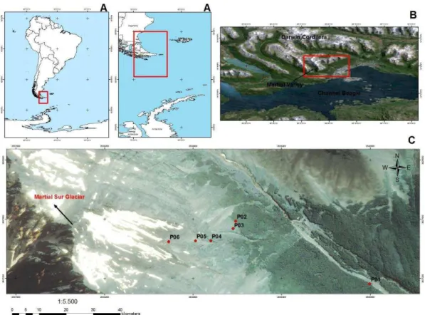
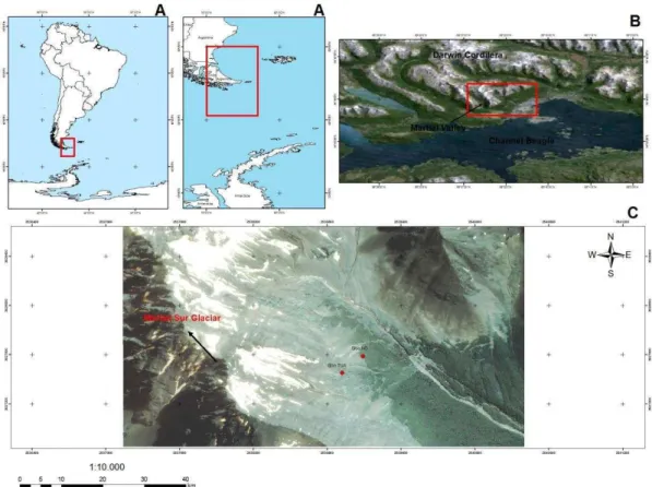
The study was carried out at the Martial glacier valley (54º46´/54º48´S;
68º22´/68º25´W), on Isla Grande (Tierra del Fuego), Argentina (Figure 1). The Cordon
Martial and glaciers, part of the mountain ranges of Fuegian Andes (Darwin Cordillera),
is located just north of Ushuaia city. Due to its proximity to the city of Ushuaia (≈ 5
km), it has been a field area for permanent monitoring studies (Strelin and Iturraspe,
2007). At the end of the summer season, melting from these glaciers provide the main
runoff in the Martial River, and represents an important water resource for Ushuaia City
(Plantas et al., 2002; Strelin and Iturraspe, 2007).
The Cordillera Oriental Fueguina is formed by strongly folded Cretaceous
metamorphic rocks, forming an east-west aligned mountain range (Strelin and Iturraspe,
2007). The metamorphic rocks of Cordillera Fueguina are composed by black shales
with quartz veins, interbedded marine turbidites and andesitic tuffs, known as Yaghan
Formation (Olivero and Martinioni, 2001). Common minerals in these rocks are:
8
meters lower than the western portion of the Chilean Cordillera Fueguina. The lower
altitude and drier climate result in a smaller glaciated area compared to Chilean
Patagonia (Strelin and Iturraspe, 2007). According to general soil descriptions
(Frederiksen, 1988), acid brown soils are the most common in this area.
Figure 1. Localization of studied area: A) The situation of Tierra del Fuego in South America and Antarctica Peninsula; B) Martial Valley, in the Darwin Cordillera; C) Studied pedons in Martial Sur sector.
The climate is cold oceanic, with strong southwest winds in late spring and early
summer (Tuhkanen, 1992). The climate fits the ET (Polar Tundra climate system) of
Köppen. The average annual temperature in the city of Ushuaia is 5.5 °C, with an
average of 1.6 °C in the coldest month (July) and 9.6 °C in the warmest month
(January) (Puigdefábregas et al., 1988). At 600 meters a.s.l. the estimated average
9
(Puigdefábregas et al., 1988). The annual precipitation at sea level is 500 mm, being
evenly distributed throughout the year, with 40-50 days with snow (Puigdefábregas et
al., 1988). The precipitation at the tree line (600 m a.s.l.) is two times higher than at sea
level (Brancaleoni et al., 2003; Iturraspe, 2011), reaching 1000 mm/year.
From the geomorphological viewpoint, the surface of the Martial valley is
strongly shaped by glacial action, related to periglacial processes such as the erosion,
transport and deposition of sediments by glacier retreat and cryogenic weathering
(Iturraspe, 2011). During the last glaciation, glacial activity was broader and intense, so
that most ice-free areas today are composed of moraines, other glacial sediments or
fluvio-glacial sediments (Pisano, 1975; Arroyo et al, 1995). According to Trombotto
(2008), during the "ice ages", most Tierra del Fuego remained ice covered or frozen for
long periods of time. Mercer (1976) mentions the most extensive glacial advance,
known as "the largest Patagonian glaciation" aged approximately 1-1.2 million years,
during which the ice cap covered the entire region of Tierra del Fuego, reaching the
margins of the Atlantic Ocean.
In the Ushuaia region today, permafrost has been considered to occur at altitude
greater than 800 meters a.s.l. (Corte, 1997; Iturraspe, 2011), or between 1000-1330
meters a.s.l. according to Trombotto (2008). The most important periglacial landforms
for the Ushuaia region are (in order of decreasing altitude): Rockglaciers, gelifluction
lobes, patterned ground, solifluction lobes and garlands (Trombotto, 2008). In the
current climatic context, the processes involving freezing and thawing occur above 650
meters altitude in soils of Mount Martial.
Deciduous forest of Nothofagus pumilio, with patches of evergreen Nothofagus
10
(Strelin and Iturraspe, 2007). In the transition to high Andean Tundra vegetation, the
Nothofagus pumilio is gradually replaced by Nothofagus antarctica, forming an abrupt
contact line in the upper limit of the forest. In this transitional zone, trees show a rapid
reduction in height, growing in a typical adaptation called "Krummholz" (Moore, 1975).
Above the tree line, the Subantarctic Tundra is predominant, with a clear transition
(Moore, 1975). According to Trombotto (2008) the Krummholz Forest indicates the
beginning of the periglacial zone, with ice-related ground processes. In Tierra del
Fuego, Tundra develops above 600-700 meters, where the average annual temperature
is below 10 °C, and soil processes are affected by seasonal freezing surficial and
thawing (Coronato et al., 2008). The Tundra vegetation is concentrated in places with
favorable microclimate conditions such as sunlight, water and nutrients, in less
wind-exposed faces, forming dense cushions on the soil surface (Brancaleoni, 2003); and
composed of dwarfed plans, adapted to extreme conditions (seasonal snow and ear
temperature) and short growing seasons (Smith, 1984; Coronato et al., 2008). The main
plant species in the fueguina Tundra vary widely, but in our study area the most
common species were: Bolax gummifera, Empetrum rubrum, Azorella lycopodioides,
Colobanthus subulatus and Muscosus drapetes, accompanied by grasses like Festuca
contracta, and different species of lichens and mosses (Brancaleoni , 2003).
2.2 Soil sampling
Soil surveying and sampling were carried out in two campaigns (May 2010 and
November 2011). Six soil profiles were collected along a topographic sequence across
the Mount Martial, between the Nothofagus forest to the ice-free area just below the
glacier margin of Martial Sur (Strelin and Iturraspe, 2007) or Circus A, as described by
Planas et al. (2002) (Table 1). Soils were sampled at different altitudes, representing the
11
Planas et al. (2002) and your own observation. Soil profiles were described and sampled
according to the recommendations of Bockheim et al. (2006).
2.3 Physical, chemical and mineralogical analyses
All routine analytical chemical and physical determinations were obtained using
standard procedures by EMBRAPA (2013) and SSSA (2014). Soil pH, exchangeable
nutrients and texture were determined for <2 mm air-dried samples (EMBRAPA, 1997).
Soil texture was determined by shaking at slow rotation (16 hours) with NaOH 0.1 mol
L-1 as a dispersant (Ruiz, 2005). The coarse and fine sand fractions were separated by
sieving whereas, the clay fraction was determined by the pipette method, and the silt
fraction obtained by difference (SSSA, 2014). Soil bulk density was obtained by the
volumetric ring, collected in triplicates (EMBRAPA, 1997).
The potential acidity (H + Al) was determined by titration, after extraction with
0.5 mol l-1 Ca (CH3COO2) at pH 7.0. Soil pH was determined in distilled water and KCl
solution 1 mol L-1 (ratio: 1:2.5) (EMBRAPA, 1997). The total organic matter (TOC)
was quantified by furnaces (SSSA, 2014). The organic matter content was established
by mass difference from the original sample dried in an oven. The carbon content was
quantified in extracts from the fulvic acid, humic acid and humin fractions by Yoemans
and Bremner (1988). The total nitrogen (TN) was determined by the Kjeldahl method
(EMBRAPA, 1997).
The Ca+2, Mg+2 and Al+3 were extracted with KCl 1 mol.L-1 solution (1:10). The
K+, Na+ and P+ available were extracted with Mehlich 1 (0.05 M HCl + 0.0125 M
H2SO4, 1:10) and determined by spectrophotometer (available P) and flame emission
photometer (Na+ and K+) (EMBRAPA, 1997). Soil pH was determined in distilled water
12
The pH in 1 mol L-1 NaF was used to verify the occurrence of low crystallinity
minerals as Perrott and Fields (1966). The remaining P (P-REM) was obtained after
shaking a sample with 0.01 mol L-1 CaCl2, containing 60 mg L-1 P (with 1:10 ratio),
according to Alvarez and Fonseca (1990) and the renaming P in solution was
determined according to Murphy and Riley (1962). The <2 mm fraction from all
horizons was examined in a petrological microscope and hand lenses to verify the
presence of volcanic glass (shards).
The minerals presents in air-dried samples (<2mm) were identified by X- ray
diffraction. The clay fraction was obtained without the use of dispersant (Gee and
Bauder, 1986) to avoid mineral alterations. The clay fraction was subjected to the
following treatments: removal of free iron by the dithionite-citrate-bicarbonate (DCB)
method (Mehra and Jackson, 1960); saturation with 1 mol L-1 MgCl and glycerol
solvation; saturation with 1 mol L-1 KCl, and heated at 350 ° C and 550 ° C for 3 hours.
The samples were analyzed using a PANalytical / X'Pert Pro diffractometer with
Cokα radiation in the 4 to 45 ° 2Θ range, at intervals from 0.017° 2θ to 1 step s−1, at a
40kV voltage and 30 mA current. The diffractograms were interpreted using Chen
(1977) charts for mineral identification.
In the fine earth (< 2mm), the following chemical extractions were also
performed: sodium pyrophosphate at pH 10 (Dahlgren, 1994); ammonium oxalate pH 3
(0,2 mol.L-1) (McKeague and Day, 1966); and dithionite-citrate-bicarbonate (DCB)
(Mehra and Jackon, 1960). After all extractions, the amount of of Fe, Al and Si were
13
3. RESULTS
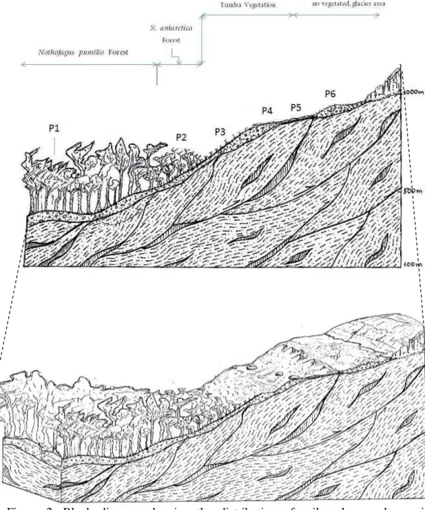
3.1 General Aspects
The six soil profiles selected represent a typical toposequence of the Tierra del
Fuego Mountain range, in which the midslope profiles under Deciduous Nothofagus
forest (P1 and P2) change to Tundra vegetation (P3 and P4) upslope, ending up with
barely vegetated soils under a periglacial environments (P5 and P6) (Table 1; Figures
2).
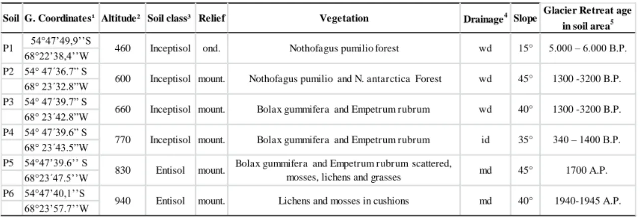
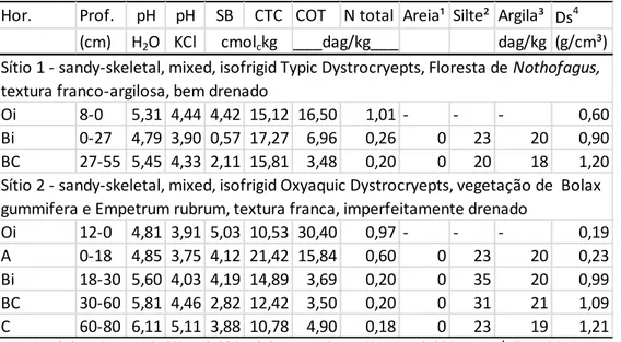
Table 1. General characteristics of studied soils – Martial Glacier
¹: Geographic Coordinates, Datum South American 69; ² Altitude in meters above sea level; ³ Orders by Soil Survey Staff (2014); 4: wd, id and md: well drained, imperfectly and moderately
drained, respectively; Glacier retreat age of studied area by Iturraspe (2011).
Soil G. Coordinates¹ Altitude² Soil class³ Relief Vegetation Drainage4 Slope Glacier Retreat age in soil area5 54°47’49,9’’S
68°22’38,4’’W
P2 54° 47´36.7” S
68° 23´32.8”W
P3 54° 47´39.7” S
68° 23´42.8”W
P4 54° 47´39.6” S
68° 23´43.5”W
P5 54°47’39.6’’ S
68°23´47.5’’W P6 54°47’40,1’’S 68°23’57.7’’W md 15° 45° 40° 35° 45° 40° wd wd wd id md mount. mount.
Nothofagus pumilio forest
Nothofagus pumilio and N. antarctica Forest
Bolax gummifera and Empetrum rubrum
Bolax gummifera and Empetrum rubrum
Bolax gummifera and Empetrum rubrum scattered, mosses, lichens and grasses
Lichens and mosses in cushions ond. mount. mount. mount. P1 460 600 660 Inceptisol Inceptisol Inceptisol 770 830 940 Inceptisol Entisol
Entisol 1940-1945 A.P.
5.000 – 6.000 B.P.
1300 -3200 B.P.
1300 -3200 B.P.
340 – 1400 B.P.
14
Figure 2. Block diagram showing the distribution of soil pedons and associated landscapes.
3.2 Soil morphology and physical properties
Soils are recent, and formed from sedimentary glacial deposits, both
allochtonous and local (fluvial and eolian) materials. Soils are shallow to moderately
deep, with a range of 45 – 60 cm to the top of the C horizon. With a thicker underlying
moraine, soil P1showed deeper C horizon (> 2 m), formed from Quaternary till deposits
(lateral moraines). The C horizon depth is less than 100 meters in midslope, decreasing
15
Soils (P1 to P4) have different colors, from dark colors at the surface (10YR 2/1
and 10YR 2/2) to reddish-yellow (higher croma) down to profile, except for periglacial
soils (P5 and P6), with no color change throughout the profile (Table 2).
At the lowest position of the toposequence, soil P1 revealed the following
sequence of horizons: Oi-Oe-Bi-Cr, under Deciduous Forest dominated by Nothofagus
pumilio further up, soil P2 under Krummholz forest showed a sequence of
Oi-Bi-BC-CR horizons. Soil P3, under Tundra vegetation, had the following sequence of horizons:
A-Bi-BC-CR. The next soil under Tundra (P4) had a sequence of Oi-A-Bi-CR horizons.
At the limit between Tundra and recently exposed ice-free area, under periglacial
conditions, soil P5 showed a sequence of A-AC-C-R horizons, and at the highest
position, soil P6 had a sequence with irregular, broken transitions between layers
(C1-C2-C3), fragmented and cryoturbic features.
Forested soils (P1, P2 and P4) are characterized by significant surface layer of
organic material (O, further subdivided into i or e) with average thickness of 13 cm. The
surface A were not observed in forested soils (P1 and P2), and the Bi horizon directly
underlies the folistic O horizon (P1), without evidence of development of the
illuviation. In Tundra soils a moderally deep (> 15 cm) A horizon occurs (P3 and P4)
with high OC; we observed the formation of either below a histic O horizon (P4) or an
ochric horizon (P3). Highland soils (P5 and P6), are weakly developed, and only soil P5
had an A horizon below the shallow ochric surface horizon, whereas as soil P6 is
skeletic, did not have A or Bi horizons.
All soils have high sand and silt contents (Table 2); and low clay content (Table
2). The sand is predominant in all soils, varying from 45 – 74% of the fine earth. The
low degree of weathering of these mountain soils was evidenced by the low clay content
16
clay), and P1 showed a silty-loam textural class (24% clay) (Table 2). Clay content
decreased with altitude, and Tundra soils have sandy-loam textural class (12-21% clay);
down to 2-12% clay in highland of the top landscape (P5 and P6). The silt/clay ratio
was > 1 in all the profiles, and varied from 1 – 12, consistent with low weathering
degree.
Soil structure was granular, weak to moderate in almost all horizons; consistency
was friable when moist, and non-sticky to slightly sticky when wet, due to low clay
content and low weathering degree (Table 2). The bulk density was low (0.2 -0.9 g/cm³)
at the surface, whereas in subsurface ranged 0.7 -1.3 g/cm³, increasing with altitude,
accompanied by greater content of coarse materials, decreasing OC contents.
At the fine earth we could detect and identify small shards of volcanic fragments
(< 500 µm), indicating an aeolian input of volcanic ash (Smith et al., 1983), consistent
with chemical analysis. Except for P6, all horizons (in surface and subsurface) have
contribution of these vitreous volcanic shards in the fine earth, as observed by hand
17
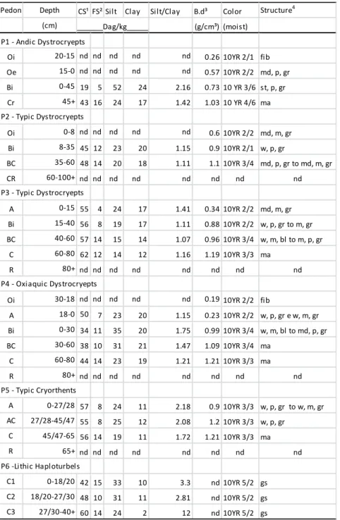
Table 2. Some morphological and physical properties of the studied soils
¹SC= Coarse Sand; ² FS= Fine Sand; ³Bulk density; 4Development: w = weak, md = moderate, st = strong. Size: p = small = medium. Type: ma = massive, gr = granular, bl = subangular blocky, sg = single grain, fib = fibric; nd = not determined.
Pedon Depth CS¹ FS² Silt Clay Silt/Clay B.d³ Color Structure4
(cm) (g/cm³) (moist)
P1 - Andic Dystrocryepts
Oi 20-15 nd nd nd nd nd 0.26 10YR 2/1 fib
Oe 15-0 nd nd nd nd nd 0.57 10YR 2/2 md, p, gr
Bi 0-45 19 5 52 24 2.16 0.73 10 YR 3/6 st, p, gr
Cr 45+ 43 16 24 17 1.42 1.03 10 YR 4/6 ma
P2 - Typic Dystrocryepts
Oi 0-8 nd nd nd nd nd 0.6 10YR 2/2 md, m, gr
Bi 8-35 45 12 23 20 1.15 0.9 10YR 2/1 w, p, gr
BC 35-60 48 14 20 18 1.11 1.1 10YR 3/4 md, p, gr to md, m, gr
CR 60-100+ nd nd nd nd nd nd nd nd
P3 - Typic Dystrocryepts
A 0-15 55 4 24 17 1.41 0.34 10YR 2/2 md, m, gr
Bi 15-40 56 8 19 17 1.11 0.88 10YR 2/2 w, p, gr to m, gr
BC 40-60 57 14 15 14 1.07 0.96 10YR 3/4 w, m, bl to m, p, gr
C 60-80 62 12 14 12 1.16 1.19 10YR 3/3 ma
R 80+ nd nd nd nd nd nd nd nd
P4 - Oxiaquic Dystrocryepts
Oi 30-18 nd nd nd nd nd 0.19 10YR 2/2 fib
A 18-0 50 7 23 20 1.15 0.23 10YR 2/2 w, p, gr e w, m, gr
Bi 0-30 34 11 35 20 1.75 0.99 10YR 3/4 w, m, bl to md, p, gr
BC 30-60 38 10 31 21 1.47 1.09 10YR 3/4 ma
C 60-80 44 14 23 19 1.21 1.21 10YR 3/3 ma
R 80+ nd nd nd nd nd nd nd nd
P5 - Typic Cryorthents
A 0-27/28 57 8 24 11 2.18 0.9 10YR 3/3 w, p, gr to w, m, gr
AC 27/28-45/47 55 8 25 12 2.08 1.2 10YR 3/3 w, p, gr
C 45/47-65 56 14 19 11 1.72 1.21 10YR 3/3 ma
R 65+ nd nd nd nd nd nd nd nd
P6 -Lithic Haploturbels
C1 0-18/20 42 15 33 10 3.3 nd 10YR 5/2 gs
C2 18/20-27/30 48 10 31 11 2.81 nd 10YR 5/2 gs
C3 27/30-40+ 60 14 24 2 12 nd 10YR 5/2 gs
18
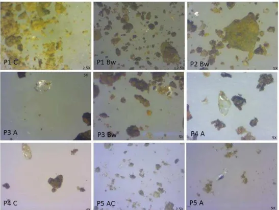
Figure 2. Selected pictures of volcanic glass particles in the fine earth of the five soils.
3.3 Chemical attributes and organic matter characterization
The total organic carbon (OC) in the soils varies much, from very low contents
(0.7%) at the highest soil to very high contents (32%) in lower landscape positions.
Overall, OC decreased in the following order: Nothofagus soils > Tundra > highland
periglacial areas. Three different epipedons were observed (Folistic, Histic and Ochric)
(Table 3).
In general, soils are acid, and the soil pH changed with altitude and depth.
Forested soils (P1 and P2) are strongly acid, with Al saturation > 60% and exchangeable
Al3+ amounts ranging from 3.4 – 3.9 cmolc.kg (Table 3). The soil pH range is 4.7 – 5.0
in the B horizons, indicating strong leaching. Tundra soils (P3 and P4) are moderately
acid with lower base saturation (31-40% in Bi), and exchangeable Al3+ amounts
between 1.7 – 1.9 cmolc.kg. Hence, Tundra soils are generally less acid than soils under
19
than 5.6, and Al3+ decreases to 0 – 0.6 cmolc.kg. At the edge of the glacier (P6), Al3+
saturation is negligible.
Table 3: Chemical properties of the studied soils.
SB = sum of bases; CEC = Cation Exchangeable Capacity; BS = base saturation; m = Al saturation; Na = Na saturation; OM = total organic carbon; TN = Total nitrogen.
The exchangeable Ca2+ contents are greater than Mg2+. Percent Bases Saturation
is rather low in subsurface (Table 3). All soils, except P6, are dystrophic. Under
Nothofagus forest (P1 and P2), biocycling of nutrients concentrates bases at the soil
surface horizon, with depth, Al3+ saturation increased and bases sum decreased. Under
Tundra (P3 and P4); the sum of bases is higher than forested soils at all depths.
Conversely, Al3+ saturation is lower. Under highland periglacial conditions (P5 and P6)
Al3+ saturation is none, with a very low weathering degree and Base Saturation percent
> 80%. The CEC at pH 7 was highest for Tundra soils, followed by forested soils, and
lowest in periglacial soils. Accordingly, the clay content decreased with altitude.
Pedon Depth pH pH P K+ Na+ Ca2+ Mg2+ Al3+ H+Al SB CEC BS m rem-P OM TN C/N
(cm) H2O KCl mg.dm-3 mg/L dag/kg
P1 - Andic Dystrocryepts
Oi 20-15 5.13 4.69 28.3 0.33 0.12 4.68 1.36 0.2 7.7 6.49 14.19 45.72 2.99 44.2 32.65 1.11 29 Oe 15-0 4.99 4.1 17.3 0.5 0.19 8.04 2.47 0.4 16.3 11.2 27.5 40.73 3.45 36.1 22.12 0.65 34 Bi 0-45 5.06 3.9 2.8 0.17 0.14 1.28 0.57 3.4 14.4 2.16 16.56 13.04 61.15 8.2 3.2 0.15 21 C 45+ 5.44 4.7 36.5 0.03 0.06 0.09 0.06 0.3 4.9 0.25 5.15 4.77 54.99 15.6 2.6 0.04 65 P2 - Typic Dystrocryepts
Oi 8-0 5.31 4.44 30 0.54 0.2 2.94 0.74 0.2 10.7 4.42 15.12 29.23 4.33 20.1 16.5 1.01 16 Bi 0-27 4.79 3.9 4.9 0.11 0.08 0.21 0.17 3.9 16.7 0.57 17.27 3.32 87.18 12.5 6.96 0.26 27 BC 27-55 5.45 4.33 8.2 0.06 0.13 1.53 0.4 1.4 13.7 2.11 15.81 13.37 39.84 7.8 3.48 0.2 17 P3 - Typic Dystrocryepts
A 0-15 5.16 3.88 5.7 0.14 0.11 3.09 1.06 2.5 16.8 4.4 21.2 20.76 36.23 12.3 7.58 0.23 33 Bi 15-40 5.54 4.19 4.6 0.05 0.09 1.75 0.64 1.7 13.4 2.53 15.93 15.86 40.23 6 4.69 0.21 22 BC 40-60 5.73 4.35 5.1 0.03 0.07 1.23 0.41 1.2 9.4 1.74 11.14 15.6 40.85 8.8 4.03 0.13 31 C 60-80 6.12 4.61 8.6 0.05 0.09 0.83 0.27 0.3 2.8 1.23 4.03 30.57 19.57 29.5 1.29 0.05 26 P4 - Oxiaquic Dystrocryepts
Oi 12-0 4.81 3.91 7.8 0.22 0.06 4.46 0.29 0.29 5.5 5.03 10.53 47.78 5.45 42.9 30.4 0.97 31 A 0-18 4.85 3.75 16.2 0.38 0.13 3.24 0.37 1.3 17.3 4.12 21.42 19.25 23.97 30.5 15.84 0.6 26 Bi 18-30 5.6 4.03 11.4 0.11 0.12 3.46 0.5 1.9 10.7 4.19 14.89 28.13 31.2 14.2 3.69 0.2 18 BC 30-60 5.81 4.46 13.7 0.06 0.11 2.44 0.21 0.6 9.6 2.82 12.42 22.73 17.52 8.2 3.5 0.2 18 C 60-80 6.11 5.11 15.9 0.07 0.13 3.49 0.19 0 6.9 3.88 10.78 35.99 0 8.9 4.9 0.18 27 P5 - Typic Cryorthents
A 0-27/28 7.5 6.75 18.7 0.08 0.1 0.57 0.02 0.59 5.3 0.78 6.08 12.79 43.15 13.1 1.46 0.07 21 AC 27/28-45/47 7.94 6.94 13.1 0.08 0.09 0.98 0.05 0.49 5.5 1.21 6.71 18.01 28.85 11.9 1.6 0.08 20 C 45/47-65 7.88 7.08 14.8 0.06 0.07 0.89 0.03 0.29 5.5 1.05 6.55 16.06 21.61 12.9 1.6 0.08 20 P6 -Lithic Haploturbels
C1 0-18/20 5.67 4.36 155 0.17 0.37 3.78 0.08 0 0.8 4.4 5.2 84.62 0 28.5 0.65 0.05 13 C2 18/20-27/30 6.15 4.49 119.5 0.18 0.28 4.04 0.05 0 0.6 4.55 5.15 88.35 0 26.5 0.54 0.03 18 C3 27/30-40 6.19 4.65 142 0.12 0.18 4.05 0.02 0 0.3 4.37 4.67 93.57 0 29.1 0.36 0.01 36
20
The value of rem-P values, that indicate the potencial P adsorption, were
variable (6 – 44 mg.L-1), suggesting that other factor besides OM and clay content
should be operating (Table 3). In the horizons examined in this study, the highest
P-retention values are observed in P1 (Bi), P2 (BC), P3 (Bi and BC) and P4 (BC and C)
and was accompanied by higher content of Al and Fe rather than Si, suggesting that
P-retention in these soils is controlled by Al and Fe-humus complexes rather than
allophanic minerals (Shoji and Fujiwara, 1984).
With reference to soil humic substances, the humic acid (HA) fraction was
predominant in all soils, especially at the surface (Table 4). In Forested soils (P1 and
P2), the fulvic acid fraction (FA) showed a small increase with depth, suggesting an
incipient, weak process of podzolization and OM mobility. Besides this, we did not
observe morphological features of podzolization process, and the low HA/FA ratio does
21
Table 4: Humic substances fractioning of the soil organic matter (P1 – P6)
FA = fulvic acids; HA = humic acids; HU = humin; TOC = total organic carbon. Humification indexes = HA/FA, (HA/FA)/TOC and (HA+FA)HU
3.4 Mineralogical results
The clay fraction mineralogy of selected horizons of pedons was analyzed by
XRD and revealed a similar mineralogical composition (Table 5). Chlorite was detected
(1.42; 0.70; 0.47 and 0.354 nm peaks) with little elimination of peaks after heating,
except for the 1.42 nm peak. Illite is also present (1.00; 0.50; 0.33 nm peaks) with no
changes following heating/solvation with ethylene glycol. Intense peaks of quartz were
also detected (0.42; 0.33 nm). Eventually, soils with a lower degree of weathering may
have quartz in the clay fraction under different climatic conditions (Jackson, 1968;
Hochella and Banfield, 1995; Kampf et al., 2009), although this mineral is usually
concentrated in the silt and sand fraction (Kampf et al., 2009) (Table 5).
Pedon HU FA HA TOC HA/FA (HA/FA)/TOC (HA+FA)/HU
Oi 29.2 0.5 0.36 32.67 0.72 0.02 0.02
Oe 11.65 0.2 2.1 22.13 10.48 0.47 0.19
Bi 1.31 1.33 0.03 3.2 0.02 0.005 1.03
O 10.35 0.93 1.27 16.5 1.37 0.08 0.21
Bi 2.32 0.79 0.35 6.97 0.44 0.06 0.49
BC 0.9 0.99 0.25 3.48 0.25 0.06 1.37
A 2.7 1.21 0.69 7.57 0.57 0.07 0.70
Bi 1.53 1.08 0.6 4.69 0.55 0.11 1.09
BC 1.08 0.88 0.4 4.04 0.45 0.10 1.18
Oi 33.69 1 32.37 30.44 32.53 1.06 0.99
A 9.4 1.49 1.55 15.85 1.04 0.06 0.32
Bi 1.57 0.88 0.38 3.7 0.43 0.11 0.80
A 0.73 0.71 0.1 2.46 0.14 0.05 1.10
AC 0.61 0.02 0.09 2.7 6.17 2.28 0.18
C1 0,37 0,25 0,41 0,65 1.66 2.55 1.78
C2 0,09 0,01 0,03 0,54 3 5.55 0.44
P5 - Typic Cryorthents
P6 -Lithic Haploturbels P1 - Andic Dystrocryepts
P3 - Typic Dystrocryepts P2 - Typic Dystrocryepts
22
Table 5. Semi-quantitative mineralogical data of the clay fraction of selected horizons (P1 – P6)
Semi-quantitative data. xxx > xx > x = Decreasing presence of the minerals;
Table 6. Selective Chemicals extractions in the P1-P6 soils
O: Mckeague e Day, 1966; P: Dahlgren, 1994; D: Mehra e Jackson, 1960.
Pedon Chlorite Interest. Illite-Mica
K-Feldspar Plagioclase Quartz Goethite
Bi x xxx xxx x x xx xx
Bi x xx xxx x x xx xx
Bi x x xx x x x x
Bi xx x xx xx xx x x
AC xxx x xx xxx xxx x x
C1 xxx x xx xxx xxx x x
P6 -Lithic Haploturbels P1 - Andic Dystrocryepts
P2 - Typic Dystrocryepts
P3 - Typic Dystrocryepts
P4 - Oxiaquic Dystrocryepts
P5 - Typic Cryorthents
(cm) NaF P1 - Andic Dystrocryepts
Oi 20-15 nd nd nd nd nd nd nd nd nd nd nd nd nd
Oe 0-15 7.37 5.1 13.2 0.52 4.3 9.1 1.2 17.3 1.17 1.53 0.52 0.68 0.84 6.97
Bi 15-45 9.9 11.5 26.4 0.64 11,0 23,0 1.8 31.3 2.47 0.78 0.73 0.87 0.95 5.78
C 45-60 11.15 12.8 3.1 2.42 4,0 1,0 1.7 9.9 1.43 3.63 0.10 0.32 0.31 3.57
P2 - Typic Dystrocryepts
Oi 0-8 7.57 3.7 5.3 0.64 2.6 1.8 1.6 6.8 0.63 1.71 0.26 0.33 0.70 5.95
Bi 8-35 9.5 10.9 13.4 0.69 7.2 11.1 1.4 13.6 1.76 5.36 0.81 0.82 0.66 3.91
BC 35-60 11.05 15.9 13.5 0.29 12.4 7.6 1.5 19.6 2.26 1.20 0.38 0.56 0.77 10.03 P3 - Typic Dystrocryepts
A 0-15 8.2 7.6 12.2 0.72 5.5 7.7 1.7 15.7 1.37 291 0.49 0.63 0.72 7.65
Bi 15-40 10.53 8.3 9.8 0.54 6.9 7.1 1.7 12.7 1.32 2.59 0.55 0.72 0.83 4.59
BC 40-60 10.65 8.1 7.3 0.65 5.9 6.1 1.6 12.4 1.17 3.38 0.49 0.83 0.72 2.04
C 60-80 9.51 3.9 4.9 0.73 1.4 3.9 1.7 8.6 0.63 3.42 0.45 0.79 0.35 1.7
P4 - Oxiaquic Dystrocryepts
Oi 30-18 nd nd nd nd nd nd nd nd nd nd nd nd nd
A 18-0 7.63 5,0 9,0 0.55 3.2 0.7 1.6 15.1 0.95 3.27 0.04 0.07 0.64 14.11
Bi 0-30 9.33 7.7 8.8 0.66 5.1 4.8 1.5 17.1 1.21 3.93 0.28 0.54 0.66 6.8
BC 30-60 10.76 12.8 12.3 0.77 9.5 4.3 1.3 18.5 1.89 4.28 0.23 0.34 0.74 13.6 C 60-80 11.08 22.8 13.6 1.64 9.7 7.4 1.5 16.9 2.96 7.98 0.43 0.54 0.42 10.54 P5 - Typic Cryorthents
A 0-27/28 10.32 7.6 8.6 0.57 4.4 5.1 1.6 13.1 1.19 5.61 0.38 0.59 0.57 5.95 AC 27/28-45/47 10.6 13.7 10.1 0.76 7.1 2.8 1.5 13,0 1.87 8.68 0.21 0.27 0.51 12.41 C 45/47-65 11,00 8.9 9.4 0.53 5.6 4.1 1.5 13.5 1.36 6.22 0.30 0.43 0.62 9.01 P6 -Lithic Haploturbels
C1 0-18/20 8.94 3.1 6.3 1.11 0.3 3.8 1.5 12.1 0.625 2.52 0.31 0.60 0.09 4.25 C2 18/20-27/30 8.92 2.3 4.1 0.71 0.3 0.2 1.7 12,0 0.435 2.81 0.01 0.04 0.13 6.63 C3 27/30-40 8.9 1.9 3.3 0.7 0.1 0.1 1.2 10,0 0.355 2.57 0.01 0.03 0.05 5.44
g/kg
Ferrihydite Fep/Fed Fep/Feo Alp/Alo
23
An interstratified mineral (possibly chlorite/Illite) was also identified by the 1.2
nm peak, with no changes following heating/solvation with ethylene glycol. The
different positions in the feldspar peaks (0.42 – 0.40, 0.36 – 0.37, 0.31 – 0.32 nm peaks)
suggest that plagioclases and K-feldspars are both present in the clay fraction, as
primary minerals.
With reference to Fe-oxides only goethite could be positively identified (0. 41,
0.26, 0.22 nm), corroborating the yellowish colors (10 YR) of these soils, even at the
highest landscape position. The amount of ferrihydrite, based on the relation 1,7 x
(Feo-Fep)% was increased in Tundra soils, and decreased in periglacial soils. Probably, the
soil condition under Tundra was more favorable to ferrihydrite by the water saturated
condition.
The content of Fe extracted by dithionite-citrate was low and varied from 6.8 to
31.3 g.kg-1 (Table 6). The highest values were in forested soils (oldest soils), especially
in Bi (P1) and BC horizon (P2). Whereas, the lowest value was observed in the Oi
horizon (P2). Although similar in almost, Fe-DCB contents decreased with altitude. In
forested soils, both Fe-oxalate (Feo) and Fe-Na-pyrophosphate (Fep) showed greater
concentrations than Fe-DCB, despite the decreasing order Fed>Feo>Fep. In forested
soils, the Feo/Fep and Alo/Alp ratios were higher than > 0.5, indicating that much of the
active Al and Fe is complexed with humus (Ping et al., 1988). The decreasing amounts
of Fe-OM and Al-OM with increasing altitude were expected, since OC decreased in
Tundra and periglacial soils, at the highest positions. The Tundra soils had a little less
extractable Fe forms, and exhibited a similar decreasing order compared with that
observed for forested soils (Fed>Feo>Fep). The periglacial soil had lower values for all
extractable Fe forms, and both Fe-oxalate (Feo) and Fe-Na-pyrophosphate (Fep) had
24
The amount of Fe extracted was slightly higher than Al, with very low Si
amounts, which is consistent with previous analyses of similar soils in this region
(Nóvoa et al., 2007; Onto-Dalmage, 1991). Al3+ extracted by oxalate was low and
ranged from 1.9 to 22.8 g.kg-1. The C horizon (P4) exhibited the greatest value, with
Alo>>Alp ratio (Table 6). Alp amounts was also low, and varied between 0.1 to 12.4
g.kg-1, with a maximum concentration in the BC horizon (P2), that showed Alo>Alp.
For both, the lowest values were detected in the periglacial environment, especially in
P6.
The amount of Sio in all soils was low (less than 3 g.Kg-1), so that the Alo/Sio
ratio is high, suggesting little contribuition of poorly crystalline aluminossilicates, such
as allophane or imogolite (Table 6). The highest values were observed in Bi horizon
(P1) and C horizon (P4). For Sip the values were very similar in all soils, and ranged
from 1.2 to 1.8 g.kg-1.
The values of pH NaF ranged from 7.3 to 11, but most soils had values above
9.4 (Table 6). Values above 9.4 can be a suitable field test to indicate the presence of
allophane and imogolite. However, pH NaF is not specific for allophanic minerals; and
can also exhibit high values with greater Al complexed by OM
4. DISCUSSION
4.1 Pedogenesis, Soil Classification and Soil Landscape Relationship
According to the Soil Taxonomy (Soil Survey Staff, 2014), the studied soils
were classified as Inceptisols and Entisols. Based on basal temperature monitoring of
soil sites (P2 and P4), all soils have mean annual temperature below 8 °C, implying a
25
permafrost can be found down to 200 cm depth, excluding the Gelisols/Crysols
classification.
Soil P1 was classified as Andic Dystrocrepts, having histic horizons (Oi e Oe),
down to 35 cm, with > 20% SOC, which is not sufficient for keying out as Histosol.
These organic-rich horizons overlie a mineral Bi, having andic properties (5 percent of
volcanic glasses, SOC < 25% in weight basis, soil bulk density < 0,90 g/cm³, phosphate
retention of 85% and Alo+1/2Feo ratio ≥ 2). The depth of Bi represents more than 60%
of this epipedon.
Hence, soil P1 would key out as Andic, with andic properties on the limit,
suggesting that this soils is subjected to andosolization more than podzolization. The
high amounts of amorphous Fe/Al minerals in the Bi, in special those associated with
organic matter, were interpreted as in situ products of weathering of volcanic glass,
allowing the formation of Fe/Al organometallic composts, typical of “non allophanic”
Andosols (Aluandic), where low Si contents, normally occur.
The P2 was classified as Typic Dystrocrept, having a shallow O horizon due to
the slope instability that is not favorable for OC accumulation. In this aspect, Frangi et
al. (2005) remark that the OM quantity under N. pumilio forest is different from
Krummholz Forest. In the latter, the C/N ratio is lower and more susceptible of
microbial decomposition, resulting in lower values of OC in this soil. Both have
accumulation of amorphous Fe and Al minerals, which may associated either with
podzolization or andosolization.
However, differently than P1, soil P2 does not meet all criteria needed for Andic
26
On the other hand, low HA/FA ratio observed in both soils (P1 and P2) with depth, does
not suggest the podozolization process, either.
Soil P3 was classified as Typic Dystrocrept, although color and OC values and
Base Saturation Percent, indicated an Ochric epipedon. Soil P3 differs from P2 mainly
by lower exchangeable Al3+ in the Bi horizon, and probably less advance pedogenesis.
The low-crystalline forms of Al increased down to the BC horizon, but are not
accompanied by similar increases in the fulvic and humic acid fractions. Possibly,
volcanic materials accumulated as ash-fall, in the mineral horizons (Bi and BC), were
not sufficiently altered to exhibit typical andic properties.
Soil P4 was classified as Oxyaquic Dystrocrept, having a fibric Oi horizon
derived from Tundra vegetation, with high TOC content (>30%), but not deep enough
to be a histic epipedon. These soils are more susceptible to chemical weathering and
erosion, following snow melting in the summer. The vegetation growth, however, can
help protect the soil from erosion at higher landscape position. Accumulation of
poorly-crystalline Fe and Al compounds was observed in the BC and C horizons, especially
when saturated with water on summer melting season.
Soil P5 was classified as Typic Cryorthent, having a deep Ochric epipedon
(>1.5% OC), overlying a mineral horizon without structural development, typical of an
Entisol. More than 35% of the total soil volume is formed by rock fragments, and the
slope is above 25% declivity. All soil horizons have a predominance of oxalate
extractable Al and Fe compounds, compared with pyrophosphate – Al/Fe extractable
forms.
Soil P6 is a Lithic Haploturbels. In these soils, OC values are very low, and the
27
lichens and mosses species. No horizons were identified, and all layers boundaries are
irregular, typical of periglacial soils. The skeletal nature is dominant and coarse material
(> 2mm) form the majority of soil material. The amount of Fe and Al extrable was the
lowest, for all forms, such as OC, AF and AH fractions. This very recent soil is the
only eutrophic of all toposequence, in contrast with the widespread acidification,
leaching and dystrophy of the lower soils, downslope. However, there are evidences of
cryogenic weathering at this landscape position.
4.2 Pedogenetic processes
The studied area lies in the Southern Circumpolar soil region (48° - 87° S),
encompassing the southern tip of South America, Subantarctic Island and Peninsular
Antarctica (Bockheim and Ugolini, 1990). At this latitude (54° S), Organic matter
accumulation, podzolization, acidification and hydromorphism are marked processes. In
addition, Frederich (1988) remarks that andosolization is also present in Tierra del
Fuego, due to volcanic ash inputs in these soils.
The forested soils of high latitude are generally subjected to frost and thawing
and freezing cycles at the soil surface, in the absence of permafrost. This may lead to
mechanical rock fracturing and formation of scree slopes (Birse, 1976). Soils are
normally richer in silt/sand fractions and coarser fragments, compared with other
highland tropical soils, since physical weathering prevails at Tierra del Fuego, with
limited chemical/mineralogical alteration (Costin et al, 1952). In contrast, clay
formation is much faster at lower latitudes and warmer climates; hence, the studied soils
have low clay content, compared to those form the South Shetlands in Antarctica
28
The accumulation of OM in Tierra del Fuego soils resembles the high altitude
Forested soils of the Brazilian highlands, where a combination of high exchangeable
Al3+, low nutrients status, brownish colors and high OM are typical traits (Benites,
1998; Dias et al., 2003; Simas et al., 2004), being often associated with podzolization
(Schaefer et al., 2002) However, besides the greater mean annual temperature in the
highland tropics, time is an important factor for soil formation, since the Tierra del
Fuego soil are much more recently exposed, following the overriding last glaciation
(14000 – 10000 y.b.p – Iturraspe, 2001). With longer time of exposition and plant
colonization, pH and Bases Saturation Percent decrease, whichever the climate
(Bockheim, 1980).
The high amounts of OM indicates favorable pedoenvironmental conditions for
carbon accumulation, except for P5 and P6, where exposure is too recent and vegetation
cover too sparse, or negligible. Despite this, according to Dobremez (1979), in the two
extremes of altitude, the organic matter is reduced: in the top mountain, became primary
production of soil carbon is very low, with low supply of organic carbon; in the lowland
areas, became the microbial turnover of OM is fast, decreasing its accumulation, by
rapid turnover. Areas of intermediary altitudes, as in the present case of Nothofagus
Forest, are favorable to OM accumulation, since biological productivity is relatively
high, with low microbial decomposition due to low temperatures (Legos, 1992).
Following OM accumulation, two pathways can land to podzolization: (1)
unsaturated fulvic acids in the topsoil, actively dissolves Fe/Al from primary minerals,
forming Metal-OM complexes that may, eventually, precipitate down the profile
(Buurman, 1987); (2) a second theory states that low molecular weight organic acid are
carriers of Fe/Al to the subsurface, leading to Fe/Al precipitation following the
29
In Tierra del Fuego, soils at between (600-1000 m.a.s.l) have pedogenetic
processes comparable to highland tropical soils of Brazil (at altitudes > 2000
m.a.s.l).According to Romanya et al., (2005) podzolization is a common process in
Nothofagus spp. dominated forest soils of Tierra del Fuego. Low temperatures induce
OM accumulation, forming Folistic horizons overlying Bi (P1 and P2). With low pH
and high Al3+ activity, microbial decomposition is hampered, leading to OM
accumulation (Allué et al., 1960; Contreras, 1975; Gutíerrez et., 1993). It is noticeable
that the lowest soils under Nothofagus betuloides forest is the most acid and strongly
leached, with a greater degree of podzolization, consistent with Etchevere and
Maczinski (1963).
The role of OM in podzolization is a classic example of OM importance in soil
formation (Buol, 1980; Van Breman and Buurman, 1998). The low nutrient availability,
notably in N and P, decreases either decomposition, with is rich in poorly decomposable
phenolic compounds and tannin. These compounds lead to complexation of metal as
percolating OM moves down, forming Bh or Bhs horizons with accumulation of
low-crystalline forms (Gomes et al., 1998; Lundstrom et al., 2000). In this respect, Benites et
al., (2001) remarks the importance of soluble humic substances (like fulvic acids) for
cheluviation and metals transport in Spodosols (Podzols).
The secondary process of hydrmorphism is also associated with podzolization,
under redoximorphic actions in ill-draned Spodosols in Amazonic (e.g. Andreade et al.,
1997; Dubrovencq and Volkoff, 1998) or in high mountain (Schaefer et al., 2002;
Benites et al., 1999). The main criteria for recognizing an spodic horizon are: water pH
<5,9; OM ≥ 0,6% and a Alo+0,5Fed ratio≥ 0,5, and at least twice as much as the
overlying illuvial horizon. The most important morphological feature of Spodosol, is
30
(Buurman, 1983). Despite this, podzolized soils without a typical elluvial horizon (E
horizon) have been described in high mountain in Brazil (e.g. Simas et al., 2005), and
elsewhere (Zanelli et al., 2006). In the WRB, when an E horizon is present, soils are
classified as Podzols, whereas when absent, soil are called Entic Podzols.
Another important pedogenetic process associated with volcanic region is
andosolization (Legros, 1992), most frequently in high mountain. In some cases, the
volcanic –ash layer can be easily distinguished by deep accumulations, but in most
cases the ash particles are comminuted distributed in the soil matrix so that a hand
lenses should be used.
According to the WRB (1998), the Spodic horizons have one or more of the
proprieties quoted below: (1) pH dependent CEC (> 8 cmolc.kg), less than 50% base
saturation; high P adsorption capacity, alkaline reaction under NaF (pH NaF > 10.3).
These properties may be also related to “Andic properties” so that some confusion may
emerge from intergrade soils, such as P1 and P2.
However, andic properties usually do not apply to spodic horizons, since
organometallic compounds are highly stable in soil layers where andic properties occur
(Shoji, 1983). Podzolization, conversely, is a soil process greatly conditioned by
vegetation, having its origin in highly mobile organic acids (fulvic acids) produced in
the surface O or A horizon, followed migration downwards to the spodic B. On the
other hand, Andosols B horizons require an in situ formation of low-crystalline
minerals, with negligible translocation from horizons, downwards. Even though, one
may find the coexistence of spodic and andic properties in a single horizon/layers, since
the two pathways can occur simultaneously. This result in typical low bulk density
31
In P1 and P2 we observed high amounts of SOM in the Bi horizon accompanied
by high pyrophosphate extractable Fe/Al, and low density, all suggesting the so-called
non-allophanic Andosols (sensu Shoji, 1993). The description of such non allophanic
Andosols (Mizota, Shoji ) are in close agreement with our results, such as high Al3+
activity, 2:1 and chlorite minerals and Fe/Al rich Humic compounds, besides
Ferrihydrite and amorphous Silica (not determined).
Regarding OM, there is a trend of decreasing amounts towards the higher
positions, closely matched by clay contents. This suggest a reducing weathering degree
with greater altitude, cooler climates and less biological activity, ending up with a
sparse vegetation cover of Subantarctic Tundra (Campbell and Claridge, 1992).
In Highland, non-Forested soils (P3-P6), pedogenetic processes are dominated
by cryoturbation and hydromorphism. Under Tundra, podzolization is much reduced. In
this regard, Schaeltg and Anderson (2005) state that Forest vegetation is a key factor for
triggering podzolization, by supplying the organic compounds required for this process.
The upland Tundra soils (P5 and P6) are the youngest, also, for having become exposed
only recently after glacier retreat, so that there was little time for soil formation (only
decades or a few centuries).
5. CONCLUSIONS
The high mountain soils of the Martial Valley are young and pedogenesis is less
intense with altitude, towards the glacier edge.
Soils are generally acidic with high Al3+ saturation, decreasing with altitude.
Barely vegetated soils close to the retreating glacier is the only presenting
eutrophic character, whereas, all other soils, notably those under Nothofagus