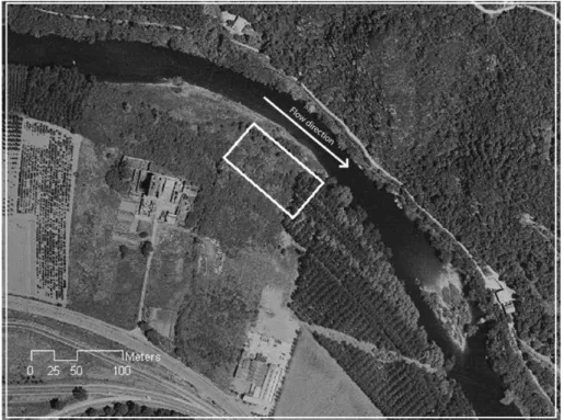
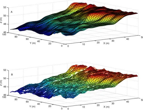
A method for parameterising roughness and topographic sub-grid scale effects in hydraulic modelling from LiDAR data
Texto
Imagem


Documentos relacionados
Managers involved residents in the process of creating the new image of the city of Porto: It is clear that the participation of a resident designer in Porto gave a
Sprinthall (1993), partindo do trabalho desenvolvido por Piaget, afirmam que os adolescentes (entre os onze e os dezasseis anos de idade) têm uma tendência para criar a
Com este mini plano de marketing, pretende-se reorganizar a estratégia global da empresa, definindo algumas linhas orientadoras que possam servir de base, para
rendimento em xilitol e um maior rendimento de etanol [Matsushika et al., 2009]. Para além da introdução de diversas vias de conversão xilose-xilulose em S. cerevisiae,
Abstract – The objective of this work was to test the extrapolation of soil-landscape relationships in a reference area (RA) to a topographic map (scale 1:50,000), using digital
Some of the existing algorithms require ancillary data such as topographic map, multiple laser returns or intensity data which may not be available, and some deal only with the
In this respect, the sub-micron scale roughness of the CTAg membrane and the release of calcium and silicate ions from the tobermorite lattice are all anticipated to contribute to
After applying the topographic correction on the spectral data, the band 4 and all the VIs showed no topographic effect, according to the values of r 2 between corrected
