University of Évora
ARCHMAT
(ERASMUS MUNDUS MASTER IN ARCHaeological MATerials Science
)
Mestrado em Arqueologia e Ambiente (Erasmus Mundus – ARCHMAT)
Diet and dynamic of the first Christians in Algarve during the
13th-14th AD
Alvaro Felipe Ortega González m40800
Cristina Maria Barrocas Dias
(Supervisor - Universidade de Évora)
Anne-France Maurer
(Co-Supervisor- Universidade de Évora)
Maria João Valente
(Co-supervisor– Universidade do Algarve)
Universidade de Évora
ARCHMAT
(ERASMUS MUNDUS MASTER IN ARCHaeological MATerials Science
)
Mestrado em Arqueologia e Ambiente (Erasmus Mundus – ARCHMAT)
Dieta e dinâmica dos primeiros cristãos no Algarve durante
os séculos XIII e XIV
Alvaro Felipe Ortega González m40800
Cristina Maria Barrocas Dias
(Orientador - Universidade de Évora)
Anne-France Maurer
(Co-orientador - Universidade de Évora)
Maria João Valente
(Co-orientador – Universidade do Algarve)
President: Professor Nicola Schiavon, Universidade de Évora;
Examiner: Professor Ana Margarida Arruda, Universidade de Lisboa/Centro de Arqueologia;
Supervisor: Professor Cristina Barrocas Dias, Universidade de Évora/Laboratorio HERCULES;
i
Abstract
Diet and dynamic of the first Christians in Algarve during the 13
th-14
thAD
Stable isotopes study of carbon, nitrogen and sulfur isotopic systems in bone remains in order to assess diet of a Christian population during the 13th and 14th Centuries AD. The population studied was from a Necropolis excavated in Cacela-a-Velha (Algarve, Portugal) and belonged to the first Christians from the Kingdom of Portugal that settled in the region after the conquest of the Algarve in the first half of the 13th century. This study seeks to provide a better understanding of the food, resources and cultural practices of the already mentioned population, in order to have a wider point of view of the reality lived by this community, and its immediate and regional context during that period of time. Differences were seen among faunal bone collagen samples, making possible to infer distinctions in agricultural practices and trading in the region. The δ13C, δ15N and δ34S results of human bone collagen evidenced
a heterogeneous diet in the population that could be caused by social and political factors. The study not only would provide isotopic data that could be used for future studies, but also, it provides a deeper perspective of the Christian societies of medieval Iberian Peninsula, since the data was contrasted and complemented with historical and anthropological information. This could be useful to provide a more complex conceptualization of the medieval Iberian cultures.
ii
Resumo
Dieta e dinâmica dos primeiros cristãos no Algarve durante os
séculos XIII e XIV
Para avaliar a dieta de uma população cristã dos séculos XIII e XIV d. C. foi realizado o estudo das razões isotópicas em carbono, azoto e enxofre em restos ósseos humanos recuperados de uma Necrópole escavada em Cacela-a-Velha (Algarve, Portugal). Estas populações, consideradas dos primeiros Cristãos do Reino de Portugal, instalaram-se nesta região após a conquista do Algarve durante a primeira metade do século XIII. Com este estudo pretende-se obter informação sobre os hábitos alimentares, utilização de recursos e práticas culturais desta população, com o objectivo de obter uma visão mais alargada da realidade vivida por esta comunidade, do seu contexto quotidiano e regional durante esse período. Foram observadas diferenças nas razões isotópicas no colagénio ósseo da fauna contemporânea aos restos humanos, permitindo reconhecer algumas diferenças nas práticas agrícolas e no comércio da região. Os resultados de δ13C, δ15N e δ34S do colagénio ósseo
humano evidenciaram uma dieta heterogénea na população que poderia ser resultante de factores sociais e políticos.
O estudo permitiu obter dados isotópicos que poderão ser enquadrados em futuros estudos, mas também, permitiu obter uma perspectiva mais profunda das sociedades cristãs da Península Ibérica medieval, já que os dados foram comparados e complementados com informação histórica e antropológica. Esta informação poderá ser útil para proporcionar uma conceptualização mais complexa das culturas ibéricas medievais.
iii
Acknowledgements
I would like to thank to my thesis Supervisors’ Professor Cristina Barroca Dias, Professor Anne-France Maurer and Professor Maria João Valente. Thank you for your kind support, patience and encouragement. I would like to aknowledge with gratitude especially to Professor Anne-France Maurer for training me in the techniques of sample preparation and giving me a deeper understanding of the topic. I am thankful to professor Francisco Curate from Universidade de Coimbra for providing the human samples, as well as to the Professor Maria João Valente from Universidade do Algarve for providing the faunal samples.
I am grateful with the Hercules Laboratory from Universidade de Evora for letting me perform the collagen extraction procedure and particularly to researcher PhD Nicasio Jiménez-Morillo and Vera Susana Correia Palma for performing the spectrometric analyses. Moreover, I would like to thank to all the Hercules Staff for their amazing kindness and availability and especially to Professor Pedro Miguel Cambeiro Barrulas and Rebbeca Anne MacRoberts for their advises, encouragement and truthness.
Finally, I would like to thank with all my heart to my girlfriend Judith Margarita López Aceves for her support, since if it was not for her, I could not be able to do this Master. I thank you for your love and support. As well I thank my parents and my brother for giving me from far in the distance their emotional and economical support.
iv
Index
Abstract ... i
Resumo ... ii
Acknowledgements ... iii
List of Figures ... vi
List of Tables ... vii
List of Abbreviations ... viii
Chapter 1 Introduction ... 1
Chapter 2 Context ... 3
2.1 Geographical context... 3
2.2 Historical context ... 11
2.21 Brief history of Cacela ... 15
2.22 The conquest of Algarve ... 16
2.23 The Order of Santiago ... 18
2.24 Medieval Diet ... 20
2.3 Archaeological Context ... 25
Chapter 3 Scientific background ... 33
3.1 Using bone geochemical composition for reconstructing past diet ... 33
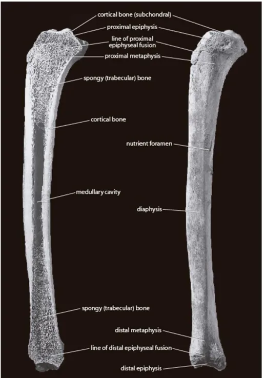
3.2 The osseous tissue: the support of the dietary information ... 35
3.3 Photosynthetic pathways: type of plant ingested via carbon isotopes ... 38
3.4 Trophic levels information through study of nitrogen stable isotopes ... 41
3.5 Fish intake and mobility investigation using sulfur isotopes ... 43
Chapter 4 Materials and Methods ... 45
4.1 Human samples ... 45
4.2 Faunal Samples ... 48
4.3 Samples for Sulfur analysis ... 49
4.4 Method ... 49
v
4.42 Carbon, nitrogen and sulfur isotope analysis ... 51
Chapter 5 Results and Discussion ... 53
5.1 Results ... 53
5.11 Preservation indicators of bone collagen ... 53
5.12 Stable isotopic composition of human and faunal bones ... 55
5.2 Discussion ... 59
5.21 Fauna interpretation ... 59
5.22 Humans ... 63
5.23 Sulfur information ... 66
5.24 Social and cultural variables ... 68
Chapter 6 Conclusion ... 83
References ... 86
vi
List of Figures
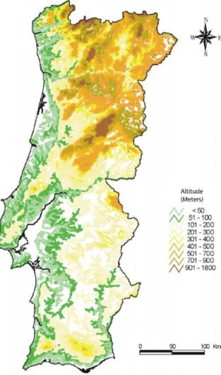
Figure 1 Hypsometric map of continental Portugal, in (Ferreira 2000) ... 4 Figure 2 Map that depicts the location of Cacela-a-Velha (represented by a Santiago Cross) within Algarve, adapted from d-maps.com ... 5 Figure 3 Medieval scene that depicts two farmers plowing a field, in Add. Ms. 41230, British Library, London. © British Library... 9 Figure 4 Map of Iberian Peninsula showing the territorial gains of the Christian Kingdoms against Al-Andalus. With a Santiago's cross is represented the location of Cacela. Portugal present territory is marked with a blue hue. This map was done through information obtained in (coord. de Oliveira Marques 1993). ... 12 Figure 5 Timeline showing historical events from 400 AD to 1100 AD in the Iberian Peninsula. Based on (coord. de Oliveira Marques 1993)... 13 Figure 6 Timeline showing historical events from 1080 AD to 1260 AD in the Iberian Peninsula. Based on (coord. da Cruz Coelho and de Carvalo Homem 1996) ... 14 Figure 7 Illuminated image of Alfonso VIII of Castile giving the castle of Ucles in 1174 to the master of the order of Santiago, Pedro Fernández de Fuentencalada, in Tumbo menor de Castilla, Archivo Histórico Nacional, Madrid, Archival nr. 1046 B, f.15 © Archivo Histórico Nacional, licence CC BY-NC 4.0 ... 18 Figure 8 Illuminated image that depicts three persons grilling chickens, in MS Bodley 264,
Bodleian Library, Oxford, Archival nr. 2464, f. 170v © Oxford University ... 20 Figure 9 Map of Cacela-a-Velha showing the excavation areas in red. The old walls of the town are depicted in grey. Adapted from (Tété Garcia 2015). ... 26 Figure 10 Silos 3 and 7 during the excavations of 2007. Photo taken from (Tété Garcia 2015). ... 27 Figure 11 Excavation plan of the Necropolis Poço Antigo in Cacela-a-Velha. Numbers were given to the individuals analyzed. The only coffin burial is represented with a brown coffin. A red clock represents the individual that was dated by radiocarbon as the earliest. A blue clock represents the individual that was dated by radiocarbon as the latest. Adaptation from (Tété Garcia 2015). ... 30 Figure 12 Photo of the excavation of 1998 of the individual 1. Photo taken from (Tété Garcia 2015). ... 31 Figure 13 Image showing the structure of a bone. Image taken from (White, Black and A. 2012). . 37 Figure 14 Carbon photosynthetic pathways, image from (Tykot 2004). ... 39 Figure 15 Graph depicting the hypothetic values of different animals' bone collagen according to their δ15N and δ13C. Image by (Tykot 2004). ... 41
Figure 16 Plot of δ34S from different aquatic environments. Plot from (Nehlich, The aplication of
sulfur isotope analyses in archaeological research: a review 2015). ... 44 Figure 17 Sex distribution of the samples ... 46 Figure 18 Age distribution of the samples ... 47 Figure 19. EA-IRMS equipment used for the analyses of carbon and nitrogen stable isotopes of this study in HECULES Laboratory. ... 52 Figure 20 Plot showing the δ13C and δ15N values of humans and animal bone collagen. Omnivore,
domestic herbivore and wildlife herbivore areas are represented with ovals. These areas were defined by the average+2σ of representative animal species: Wild (rabbits and deer), domestic (sheep, goats and cows), omnivores (pigs and chickens). In a gray hue the faunal and human
vii Figure 21 Boxplots of δ13C and δ15N values of human bone collagen. In the plot of the left is
possible to appreciate two outliers. ... 63 Figure 22 Plot showing δ13C and δ15N values of human and faunal bone collagen. Areas A, B, C and
human outliers are shown. The human mean+1σ area is shown by a shaded circle. A cross represent two standard deviations. A trophic offset between domestic herbivores and humans mean is
represented by arrows... 64 Figure 23 Dispersion plot of δ13C values contrasted with δ34S values, and δ15N values with δ34S
values. Two different areas are shown to differentiate δ34S values in faunal samples. ... 67
Figure 24 Dispersion plot showing human bone collagen values differentiated by sex. The numbers correspond the sample number without the acronym H-CVPA. ... 69 Figure 25 Dispersion plot showing human bone collagen values differentiated by age. The numbers correspond the sample number without the acronym H-CVPA. One standard deviation is
represented of each age group. ... 71 Figure 26 Map showing the location of the enlisted sites in Table 3 in the Iberian Peninsula.
Adapted from d-maps.com ... 75 Figure 27 Plots showing the diverse δ13C and δ15N values with one standard deviation of the sites
listed on Table 3. Cacela values are marked in red. Tomar and San Pedro de Nora are marked in black due to their similarities in human/domestic animals spacing. ... 76 Figure 28 Graph depicting trophic offsets from the sites listed in Table 3. A red point represents Cacela. A blue oval shows the similarities between San Pedro de Nora and Tomar values with Cacela. ... 78 Figure 29 Faunal samples photos. From left to right are presented as they were mentioned in Table 4. ... 95 Figure 30 Human sample photos. From left to right are presented as they were mentioned in Table 5. ... 100
List of Tables
Table 1 Carbon, nitrogen and sulfur stable isotopes from faunal bone collagen with indicators of quality. ... 55 Table 2 Carbon, nitrogen and sulfur stable isotopes from human bone collagen with indicators of quality. ... 57 Table 3 listing different stable isotopes studies on Christian medieval populations. Location, period of time and δ13C and δ15N averages with a standard deviation of the sites are presented. The trophic
offset between the populations and the domestic baselines used on those studies are also shown. .. 73 Table 4 Analyzed faunal samples. ... 94 Table 5 Individuals analyzed. Diseases that were recorded in the bone tissue are presented. ... 96 Table 6 Faunal and human samples used for sulfur analysis ... 101
viii
List of Abbreviations
AD: Anno Domini
AIR: Ambient Inhalable Reservoir BP: Before Present
C: Carbon
C/N: Carbon to nitrogen ratio C/S: Carbon to sulfur ratio
CAM: Crassulacean Acid Metabolism CVF: Cacela-a-Velha Fortaleza
EA-IRMS: Elemental Analyzer - Isotope Ratio Mass Spectrometry H-CVPA: Human Cacela-a-Velha Poço Antigo
IAEA: International Atomic Energy Agency N: Nitrogen
N/S: Nitrogen to sulfur ratio S: Sulfur
VCDT: Vienna Canyon Diablo Troilite VPDB: Vienna Pee Dee Belemnite
1
Chapter 1 Introduction
Between the subjects that the diverse disciplines that study the past address, the study of diet acquired a great importance, since food consumption is one of the determinants in our social, cultural and biological conformation (Harris 1987). Food is what led us to develop in a specific way. Our own body and our way to understand reality depend, or at some point depended, on what we eat. The evolution of humanity is strongly linked to it; nevertheless, food does not only depend on biological and subsistence terms; it also has clear social, historical and cultural components (Harris 1987).
The geography of a place determines what kind of plants is possible to grow and what animals are possible to breed. The birth of agriculture depended mainly in the latitude and the proximity to water resources. That is why in temperate or tropical areas is where most of the plants we consume today were domesticated (e. g. Indus Valley, Valley of Peru, China, Mesopotamia, Egypt, Mesoamerica). Coincidentally, it is in these same places that diverse civilizations were born (Wolf 2005).
Diet determines culture. It is not surprising that even in many religions the importance of certain foods was reflected in the form of diverse deities. Likewise, culture determines diet too. Examples of it are all over the world, in which the type of food is strongly linked to popular beliefs, religious ideas, age or sex (Harris 1987).
Human nutrition is also associated with temporality and social stratification. The consumption of certain products depends both on the epoch lived, as in the availability of these products and the possibility of individuals to afford them. Thus, the study of past diets can provide a large amount of information to understand in a more objective way the worldview of past societies, as well as our own.
This study comprehends the period between the 13th to the beginning of the 14th century in the town of Cacela-a-Velha, that is localized in the south of Portugal in the region of Algarve. During this period the kingdom of Portugal conquered the region, finishing in the year 1249 the Muslim occupation period of the nowadays Portuguese territory. The situation lived in that epoch is known partially and mainly through written sources. There are many historical
2 studies dedicated to this period; however, many questions are still not answered. The study of past diets may reveal new perspectives relative to the way of life of population during medieval times and to understand how diet is crucial in the conformation of identities (Harris 1987). This study aims to supplement the existing information through a different methodology, since most of the studies have been done from ethnographic and documentary sources. For this, stable isotopes analysis of bone remains was employed.
Stable isotopes studies are based on the fact that the composition of the tissues of an organism has a direct relation with what it ingests. In other words, the consumer’s tissues reflect the food that was ingested. In this way, osseous tissue become a repository and evidence of past diets.
The bone remains analyzed are part of the excavations that took place in the years 1998 and 2001, in a cemetery dated from the 13th Century AD (Tété Garcia 2015). The set of
samples analysis within this study is composed by 42 human samples and 28 faunal samples. Faunal samples are required in the study to relate the information obtained from the human bones with the environment where the humans lived, and to infer what was the contribution of those animals to the human diet.
The specific objectives of this study are to analyze diet through three different isotopic systems: 15/14N, 13/12C and 34/32S, and with that be able to understand if there were differences on diet that could be related with social status, migrations, ideology or beliefs. Finally, since faunal samples were analyzed, another objective is to find out if there were different husbandry practices and how these could be related with different agricultural practices.
The methodology employed consisted in recording and classifying the bone samples, after which their collagen was extracted for posterior analysis. Afterwards, the information was interpreted taking in consideration historical and anthropological information. In this way, through an interdisciplinary approach, a clearer picture of the population way of life was gained.
3
Chapter 2 Context
2.1 Geographical context
This section will discuss the geographical, geological and climatological characteristics of the immediate, local and regional context of Cacela-a-Velha, a town of the south coast of Portugal. Also, it will include the environmental changes throughout time, as well as the formation and territorial definition of the region, and its geomorphological differences with the rest of the Iberian Peninsula.
Portugal, it is worth to mention, is a land in which many of its characteristics are binary, and, the country’s geography is not an exception. Generally speaking, Portugal, in contrast with other Mediterranean countries that are located on the boundaries of the Eurasian plate, does not present such a rough terrain. In fact, it is a country where areas with low altitudes predominate, since, more than the 70% of the territory is located at less than 400 meters above sea level, and only 12% is above 700 meters (Ribeiro, Portugal o Mediterrâneo e o Atlântico 1993). The lack of high mountainous terrains is particularly evident in the southern regions.
The climatological conditions of Portugal are reigned, to a large extent, by the unequal behavior in temperature between the masses of water from the Atlantic Ocean, and the Hispanic plateau. This is because during the summer, ocean waters are colder than the Iberian lands, while, during the winter, it occurs the opposite. Due to this alternating action between land and sea, the variation of meteorological elements has a clearly west-east component (De Pina Manique e Albuquerque 1954). In this sense, Portugal and Galicia act as a barrier that limits the actions of the Atlantic cyclones in the rest of the peninsula (Lautensach 1967).
Traditionally, Portugal is divided in two major regions: South and North, and this has its logic, not only due to historical reasons, but also as a result of orographic features. The divisor line that defines both regions is the Tagus river. South of Tagus, 97% of the land is located at less than 400 meters above sea level, and only 0.2% above 700 meters (Figure 1) (Ribeiro, Portugal o Mediterrâneo e o Atlântico 1993). This create a completely different
4 landscape in the south from the one in the north. It is in the south, where is located the vast and monotonous land of Alentejo, that extends south until it is stopped by the mountains in the north Algarve, and in which its broad plains with cereal crops and groves from olive trees and cork oaks, with vineyards scattered on the landscape are characteristic.
The latitude and low altitude of these landscapes condition their hydrological features. In this way, Northern to Tagus region usually has a precipitation media of 1000 to 2000 mm per year, while the southern counterpart, unlike, is far much dry. Only in Monchique range and São Mamede range the precipitation has a media of 1000 mm. In Alentejo the rains do not arise further than 700 mm, while in the Guadiana basin it does not exceed 500 mm, having some years where the precipitations media is of 350 mm. Whereas in the north only two months per year are considered dry, because they present precipitations below 30 mm; by comparison, in the south there are three to six dry months (Ribeiro, Lautensach and Daveau, Geografia de Portugal. O Ritmo climático e a Paisagem 1999) (Ribeiro, Portugal o Mediterrâneo e o Atlântico 1993).
Cacela-a-Velha is a town located in the eastern part of the Algarve (see Figure 2), one of the regions of Portugal. This region is the most southern of the country and it extends from the coast of the Atlantic Ocean to the frontier with Spain, where the Guadiana river divides Figure 1 Hypsometric map of continental Portugal, in
5 them. Nowadays, the zone that comprehends this region is the District of Faro; nevertheless, in the past, its area was larger.
The geographical area that the Algarve region comprehends was mentioned for the first time in history by Herodotus as a part of the Tartessian civilization. Afterwards, it would be mentioned by Polibio as Turdetania, in which the Turdetani and Cynetes people lived. It is until the Roman Empire when this region would be well defined as a Roman province, and it would be given the name of Lusitania. After the fall of the Western Roman Empire, the region passed to be controlled first by the Vandals, then by the Suebi, and after by the Visigoths, with a small period in between, in which the Eastern Roman Empire controlled the area, but the Visigoths could stablish again their rule (coord. de Oliveira Marques 1993). This region would not change during the Germanic invasions and the Visigoth kingdom (Stanislawski 1963). In the context of the Muslim invasion and their posterior settlement, the region would be redefined. The region would be named al-Gharb, that in Arabic means west, and its geographical limits would change with the course of time.
Figure 2 Map that depicts the location of Cacela-a-Velha (represented by a Santiago Cross) within Algarve, adapted from d-maps.com
6 It is worth to mention that with the Muslim conquest the region would see its blooming. While it is true that the area was developed during the Roman rule too, it is also true that the territory constituted a remote peripheral area, in which, it is plausible that the interests over this land were not a priority (Stanislawski 1963). In contrast, through the five centuries that Algarve was part of Al-Andalus, a vast quantity of developments was introduced, mainly in agriculture and irrigation practices. These improvements would lay the foundations for the present development aspects of the region.
Inside Algarve, the region is divided in two different ways that have an ecological reason. First, it is divided in two areas that have different climatological characteristics. These are: Sotavento and Barlavento. The latter extends from Cape São Vicente to Olhos de Água, and its weather conditions are subject to Atlantic influences; the former, Sotavento, extends from Olhos de Água to the delta of the Guadiana river and it is subject to climatic characteristics that are more similar to those of the Mediterranean, being more exposed to continental winds. Besides the differences in climate of these two regions, the contrast in geomorphological features is also quite significant. The coasts of Barlavento are characterized by a strong marine erosion with high calcareous cliffs, while Sotavento, in contrast, is constituted by a lower altitude coast with long sandspits of a more recent formation (Instituto de Conservação da Naturaleza e das Florestas 2007). To sum up, Barlavento is exposed to erosion processes and Sotavento to sedimentary processes.
Besides Sotavento and Barlavento divisions, Algarve is divided in three different regions that are defined by their sea level. These are Serra, Barrocal and Litoral and are constituted by three longitudinal strips that go from north to south. Serra is characterized by a rough relief that does not go above 500 meters above sea level with a singular exception that is the Monchique range, in Barlavento; an area that rises almost till 1000 meters. Barrocal is a territory that has been shaped by the erosion of the distinct rocks, creating a landscape of diverse shapes, and its maximal altitude is 410 meters in São Miguel hill. The Litoral region is characterized by the smoothness of the relief, and it covers an area of low altitudes, that do not exceed 60 meters, in which altitudes of 20-30 meters predominate (Instituto de Conservação da Naturaleza e das Florestas 2007).
7 The formation of the Algarve can be attributed to different geological processes that started in the Paleozoic period and that followed till the present. The northern part of the region, Serra, is composed by Paleozoic soils, where two reliefs of different formation appear: the Caldeirão range, of tectonic origin, is covered by schists and greywackes, and, the Monchique range of sub-volcanic formation from the superior Cretaceous period, is covered mainly by syenites (Instituto de Conservação da Naturaleza e das Florestas 2007).
Going south, in the Barrocal, the compact and marly limestones and dolomites dominate the region and are usually associated with the Jurassic and Cretaceous formations. This area presents formations of karstic type, with frequent depressions and vertical caves, since limestones are chemically rich in calcium carbonate which induces a process of alteration by dissolution. Thus, the reliefs are interspersed by floodplains and depressions, covered by very fertile clayey and loamy materials (Instituto de Conservação da Naturaleza e das Florestas 2007).
Towards the sea, in the Litoral, the age of the geological formations diminishes as one moves east. North from the Cape of S. Vicente, the coastal formations are essentially Paleozoic, constituted by schists and greywackes, whereas, from this Cape to the east, Jurassic, Cretaceous, Miocene, Pleistocene and present formations arise in an intercalated form. In the Sotavento, the Pleistocene deposits of sands are composed of micaceous silts and fine sands, which are followed by gravels with rounded quartz, quartzite or greywacke pebbles. The barrier islands of the Ria Formosa are formed by dune sands, which are usually accompanied by beach sands, which feed the dunes (Instituto de Conservação da Naturaleza e das Florestas 2007).
In particular, the formation base of Cacela and its stream contains Galvanas’ conglomerates, which are composed by blocks of Jurassic calcareous rocks, Cretaceous sandstones and igneous rocks, together with sands and silts with some glauconites. The formation of Cacela dates from superior Tortonian to Messinian periods and it was dated by the Galvanas’ conglomerates, ostracod fauna and calcareous nanoplankton (Oliveira 1992 ).
Coarse sands and pebbles from metapelites, sandstones and volcano-sedimentary rocks from the upper Triassic and lower Jurassic are deposited on schists and greywackes of the carboniferous period. Along the stream of Cacela, shallow levels of fossiliferous
8 conglomerates settle with angular discordance in sandstones from the Triassic, followed by, silts and fine sands of greenish, orange and grayish hues, and, it also settles high amounts of fossils, specially malacological. All of these characteristics make the soils of Cacela to have a high content of soluble salts (Instituto de Conservação da Naturaleza e das Florestas 2007, Oliveira 1992 ).
Besides the physical conformation, one important feature that is necessary to address for understanding the reality of the region is its vegetation. For this, it is not enough to know the flora of present time, but to seek testimonies through micro and macro remains that are studied by Archaeobotany. Thanks to these studies, it is plausible to understand which were the plants that were introduced by the humans, in which period and the importance that those plants have in such a specific location.
The flora of the Algarve contrasts with its northern counterpart Alentejo due to anthropogenic factors. While in the latter, cereals and vines are abundant thanks to its flat landscape; in the former, the type of vegetation has characteristics not only of Mediterranean, but also from sub-tropical latitudes. Before human intervention, the vegetation of the region, as well as in many Mediterranean regions, was composed of plants with evergreen perennial leaves adapted to semi-arid weather. Some of the native flora would be holm oaks (Quercus ilex), carobs (Ceratonia siliqua), cork oaks (Quercus suber), strawberry tree (Arbutus unedo), mastic (Pistacia lentiscus), hackberry (Celtis australis) and wild olive trees (Olea europaea var. sylvestris) (Tété Garcia 2015). The area of the Serra preserves most of these features in the present.
The Barrocal and Litoral share a flora more similar with the one of the Maghreb and in this area were introduced more plants of sub-tropical environments. This is due to the fact that the Monchique range stops the cold winds of the north Atlantic. Between the plants that were introduced by the human populations are the domesticated olive tree (Olea europaea) that is believed that was introduced before the roman period, as well as the fig tree (Ficus carica) and the vines (Vitis vinifera). During Roman times many fruit species were brought into the Peninsula. Those would be peach (Prunus persica), plum (P. domestica), sweet cherry (P. avium), apple (Malus domestica), pomegranate (Punica granatum), melon (Cucumis
9 melo), cucumber (Cucumis sativus), and walnut (Juglans regia) (Peña-Chocarro, Pérez Jordá, et al. 2019).
In addition, the variety of fruits was enriched during the middle ages. Thanks to migrations, especially in the Muslim ruled territories, new products began to be commercialized. One of the first products introduced were citrus fruits, which fit perfectly in the Algarve thanks to its high soil fertility. Also, medlars (Mespilus germanica) and apricots (Prunus armeniaca) were introduced in this epoch. The latter appears for first time at Mértola during the 11th and 12th century AD (Peña-Chocarro, Pérez Jordá, et al. 2019). It is also during this time that the first remains of quinces (Cydonia oblonga) in the peninsula are confirmed (Peña-Chocarro and Pérez-Jordá, Los estudios carpológicos en la Peninsula Ibérica: un estado de la cuestión 2018).
Aromatic plants cultivated in this region were oregano (Origanum vulgare), rosemary (Rosmarinus officinalis) mint (Mentha spicata), parsley (Petroselinum crispum), coriander (Coriandrum sativum) and fennel (Foeniculum vulgare), vegetables used as fodder for animals such as lucerne (Medicago sativa), and vegetables like celery (Apium graveolens) and carrots (Daucus carota subsp. sativus) (Peña-Chocarro and Pérez-Jordá, Los estudios carpológicos en la Peninsula Ibérica: un estado de la cuestión 2018). Another exotic introduction that were possible to cultivate in the Algarve thanks to irrigation technologies were cotton plants (Gossypium genus), bananas (Musa paradisiaca) and sugar cane (Saccharum officinarum) (Tété Garcia 2015, MacKinnon 2015).
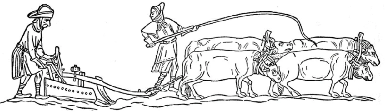
Besides the study of botanical macro remains, micro remains can add information of other type. Between these, pollen is useful to reconstruct past landscapes, and, in this way, Figure 3 Medieval scene that depicts two farmers plowing a field, in Add. Ms. 41230, British Library,
10 understand the evolution of a region, whether its climatic, vegetation or geomorphological attributes. Nowadays it is known that, on account of palynological studies, the region usually oscillates between large periods of time with drier weather, and other periods that present larger amounts of precipitation.
In the course between Mesolithic and Neolithic times, the area presented evergreen and deciduous forests of Quercus and Pinus types. Then, in the middle of the Neolithic period, the remains showed signs of an increase of anthropogenic land use with a high amount of pollen from Ericaceae, Cistus, Arbutus, Pistacia, Cerealia and Olea types. Besides, it is shown an increase of charcoal remains that could be evidence of a drier period. After, during the Copper age, there is a decrease in the presence of trees. This could be associated with the high demand of wood that was necessary on that epoque for the production of copper alloys. Afterwards, throughout the antiquity, there is an increase in Olea and Vitis vinifera, a characteristic that became more patent during the Roman period. Also, at the same time, there is evidence of a clear development of land use for animal husbandry and agriculture. Already in medieval times, along the Islamic period that comprehends the emirate of Cordoba there is a decrease of land use. In contrast, during the Caliphate period and after, there is a clear increase of deforestation due to agricultural practices (Schneider, et al. 2016). Taking all of this into consideration, we can understand certain features of the weather of Algarve during history. As stated by (Schneider, et al. 2016, 61):
Drier periods along the Algarve coast existed prior to 8000 cal BP, around 7000 cal BP, between 6400 and 6200 cal BP, between 5000 and 3300 cal BP, between 2800 and 2500 cal BP, between 1300 and 1050 cal BP and between 700 and 500 cal BP.
During the time-lapse that this study focuses, the environment would be in the border between a normal precipitation period, and a dry period (700-500 BP), that, even with less rain, would not affect the agriculture of the region thanks to irrigation practices that do not depended on rainwater but on subsoil water. The evidences of land use are, besides deforestation, an increase of macchia mediterranea, ruderal and grassland that act as indicators (Schneider, et al. 2016). This argument is also supported by historical sources, in which agricultural production was not affected (Stanislawski 1963).
11
2.2 Historical context
After the decline of the Western Roman Empire as a political entity, multiple groups of Germanic origin settled in different provinces of the empire. Within the context of the Iberian Peninsula, the two Germanic peoples that settled were the Suebi and the Visigoth. These two kingdoms coexisted for a century, until the Visigoth Kingdom defeated the Suebi in 585 AD and consolidated as the only power in the Peninsula (coord. de Oliveira Marques 1993).
The Visigoth footprint left almost non kind of trace in the Algarve. Culturally speaking, the influence that Germanic peoples contributed was minimal, since, before entering the peninsula, the Visigoths had already been “Romanized” and were the ones that achieved hegemony in the territory (Quirós Castillo, Loza Uriarte and Niso Lorenzo 2013). In the year 711 AD, The Umayyad Caliphate defeated the Visigoth forces in the Battle of Guadalete. The victory of Guadalete joined with the internal conflicts that the Visigoth State was passing through opened the doors of the Iberian Peninsula for the Umayyad Caliphate (coord. de Oliveira Marques 1993). With this event, the Muslim occupation period of the peninsula started.
The period known as “Reconquista” in the Iberian Peninsula was a very complex process influenced by factors of different kinds through its development. This geographical area experienced a unique dynamism, as it became the meeting place between the feudal European Christian society, and one of the most recent ideological political movements that had arisen in the Middle East, and that became a phenomenon in most of the world: Islam. The meeting of these two macro cultures complicated the reality of peninsular society in an ambivalent way. On one hand, it brought political and ideological conflicts, social changes and war. While on the other, it led to a cultural and biological miscegenation, new ways of understanding otherness, it also produced greater dynamism between social classes, introduced new technologies that increased productivity in the countryside and led to transformations in the ways society was organized (coord. da Cruz Coelho and de Carvalo Homem 1996, Stanislawski 1963).
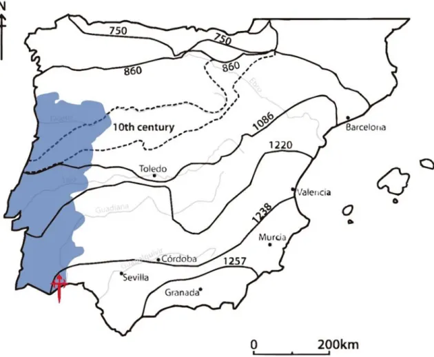
12 At certain times, the Iberian Peninsula meant a constant battlefield, both militarily and ideologically, while at other times this period meant renaissance. Although it is such a long and full of nuances period, this study’s temporality lies on posterior centuries (13th and 14th AD). In order to narrow and define both the period and the geographical space of this study, the facts prior the conquest of Algarve will be presented in the next timelines (see Figure 5 and Figure 6) and the territorial changes will be presented in the Figure 4.
Figure 4 Map of Iberian Peninsula showing the territorial gains of the Christian Kingdoms against Al-Andalus. With a Santiago's cross is represented the location of Cacela. Portugal present territory is marked with a blue hue. This map was done through information obtained in (coord. de Oliveira Marques 1993).
13 F ig u re 5 Timelin e sh o w in g h is to rica l e ve n ts fr o m 4 0 0 A D to 1 1 0 0 A D in th e Ib eria n P en in su la . B a sed o n ( co o rd . d e Oliveira Ma rq u es 1 9 9 3 )
14 F ig u re 6 Timelin e sh o w in g h is to rica l e ve n ts fr o m 1 0 8 0 A D to 1 2 6 0 A D in th e Ib eria n P en in su la . B a sed o n ( co o rd . d a C ru z C o elh o a n d d e C a rva lo Ho me m 1 9 9 6 )
15
2.21 Brief history of Cacela
The first evidence of population in Cacela-a-Velha belongs to the last period of Roman Iberia (4th AD), in which a ceramic oven and some pools for preparation of garum, a
fermented fish sauce, were found (Tété Garcia 2015). There are no evidences that could relate it to a settlement of a bigger scale, neither in this epoch nor in the following five centuries.
According to the historian of the ruling period of the Caliph al-Hakam II, Isa ibn Ahmad al-Razi, the first fortress of Cacela was founded in the 10th century, under the defensive construction policy of Abd al-Rahman III; nonetheless, there are no archaeological evidence to confirm al-Razi's reference. The name Cacela comes from this period, and it is an evolution of Qastalla Darraj, title of a noble arab family: the Darraj Alcacetali. The main objective of the fortress during this period was to protect the naval route that went to Tavira and Ossonoba. As a secondary purpose, the harbor of Cacela served as a refuge for ships that navigate through the Guadiana river, but due to meteorological reasons, they were not able to navigate upstream (Tété Garcia 2015).
After the Caliphate of Cordoba was dissolved in small kingdoms (taifas) and local rulers, the territory of present Algarve was distributed between Silves, Huelva and Santa Mariya. Cacela-a-Velha was part of the Taifa of Huelva in 1012, and then, it passed to be part of the Taifa of Santa Mariya (Faro), when an aristocratic family called the Banu Harun rebelled and created this latter Taifa in the year 1026. Years later, in 1051, the Taifa of Santa Mariya became part of the Taifa of Seville (coord. de Oliveira Marques 1993).
During the Almohad occupation of the Peninsula, the defenses of Cacela were improved as a policy of fortification of the whole al-Gharb, and most probably the silos were constructed at this time following this logic. Cacela became the most important base and harbor of military support from the west of the peninsula. To make this possible, a large number of people immigrated to the town to be part of the building force, to become a member of the military forces or to cover diverse services. Due to this demographical increase in a short period of time, it was necessary to build houses outside the walls, and the quartier of Poço Antigo was established (Tété Garcia 2015, Stanislawski 1963).
16
2.22 The conquest of Algarve
The kingdom of Portugal, through favoring politically the military religious orders – especially the order of Santiago–, consolidated its forces and advanced southward, and, by 1234, all the Alentejo region was conquered. From 1238 to 1240 Mértola fell and the entire border of the Guadiana was opened to the Christians. In 1240, Paio Perez Correia, member of the Order of Santiago, conquered Cacela and Aiamonte with naval support. Two years later, the Portuguese rule in eastern Algarve was consolidated with the fall of Tavira (Tété Garcia 2015).
In 1240, the headquarters of the order of Santiago remained for a while in Cacela. Around this period, the quartier of Poço Antigo was burned down and the space started to be used as a cemetery. Next to this, the church of Nossa Senhora dos Mártires was built, which became a center of devotion of all Algarve region (Tété Garcia 2015).
The participation of the Templars in the conquest of the Algarve was small, because its resources at that time were concentrated in the war against the Ayyubid Sultanate in Egypt. It is also possible that political instability inside the order had influenced their actions, since the Grand Master of the order had disappeared in 1244 during the Battle of La Forbie in Gaza. After the conquest of Silves (1245) in the Barlavento, the military campaign stopped for Sancho II, because a civil war started. The conflict ended 2 years later, in 1247, and, as a result, Sancho II was substituted by his brother Afonso III on the throne. The civil war had its causes in the second half of the previous decade, in which the whole territory of Portugal, especially in the north, were passing through constant violence, crimes and pillage that the State was unable to control. The word of the king had weight in the cities, but in rural areas and in peripheric regions the absence of the State was evident. In addition to this, the king began to grant more political power and properties to the military orders, since the main objective of the ruling period of Sancho II was to conquer the Algarve. Therefore, the religious military orders were beneficiated, specially three of them: the Order of the Temple, the Order of Avis and the Order of Santiago (Fernandes 2011).
The benefits and power that these orders were gaining was so evident that it started to begin to bother the Portuguese nobility and secular clergy. The Mestres and the
17 Comendadores of the orders had such influence and power that they could even harass and perpetrate injustices against nobles and high figures of the clergy without any obvious consequence. Ultimately, it was the huge impunity and fear that the military orders generate what it took for the noblemen and high clergy to put on the Portuguese throne a king which was closer to the secular clergy (Fernandes 2011).
During the reign of Afonso III, the Muslim rule in the western part of the Peninsula vanished, when the city of Santa Mariya (Faro) was conquered in the year 1249. Some months later Loulé fell. The conquered territories in Algarve were given to the Order of Santiago, with exception of Albufeira and Porches. These were given to the Order of Avis and to the Chancellor-Master Estevão Eanes respectively (Tété Garcia 2015).
After the conquest had finished, the region stayed militarized, especially the Sotavento, where conflicts between Portuguese, Castilians and local populations where usual. In that time, the Guadiana surroundings became a focus of violence, in which the local population suffered many abuses and many Muslims were slaved. The ones that were not slaved were forced to pay taxes, and, after the Mudejar rebellion of 1264, they were relocated in morerias (neighborhoods in which Muslim communities were segregated) (Tété Garcia 2015).
To mitigate the abuses on the Muslim population and to make sure that they continued paying taxes to the Portuguese crown, the king made an agreement with the Order of Santiago to fix the Muslim population in the territory, avoiding migrations to other areas in the Peninsula still ruled by Islamic states. In this way many populations from Muslim origin stayed. Some years later, in 1286 during the reign of Dom Dinis, Cacela got a royal code of law, foral. In the foral document of Cacela, a numerous Muslim community is mentioned, and they should pay the quinto real (20% tax). The location of this population is uncertain but is believed that could be somewhere in the western part of the border of the term of Cacela (Tété Garcia 2015).
For the last years of the 13th century and the beginning of the 14th, the port of Cacela lost leadership in the region. One of the reasons was that the sand barriers of the lagoon started to complicate ship’s movements. Another reason was that Castro Marim started to become more important because of its location in the delta of the Guadiana river. At the same
18 time, Tavira emerged as the port of the Sotavento of Algarve. In the following centuries Cacela started to decrease in population (Tété Garcia 2015).
2.23 The Order of Santiago
During the Almohad period, the military Order of Santiago was established in the kingdom of León, in order to take care of the pilgrims on the road to Santiago and safeguard the borders of the kingdom. The order was established by mandate of King Ferdinand II of León in conjunction with Celeberrimo (Cerebruno) archbishop of Toledo; João Peculiar, archbishop of Braga; Pedro Gundesteiz, archbishop of Santiago de Compostela; Ferdinand the Elder, bishop of Astorga and Esteban, bishop of Zamora, in the year 1170. However, the organization was recognized by Rome only in 1175, when Pope Alexander III granted them a papal bull. By this time the Order was already extended outside the borders of the kingdom of León.
The philosophy of the Order was extremely binary (faithful-unfaithful), which sought to bring nobles to their ranks, in order to increase the dominance of the Christian kingdoms. To
Figure 7 Illuminated image of Alfonso VIII of Castile giving the castle of Ucles in 1174 to the master of the
order of Santiago, Pedro Fernández de Fuentencalada, in Tumbo menor de Castilla,Archivo Histórico Nacional, Madrid, Archival nr. 1046 B, f.15 © Archivo Histórico Nacional, licence CC BY-NC 4.0
19 attract them, they gave the conflicts a holy war character, where the enemy was the sin itself. They were ideologically based on preaching that it was the Holy Spirit who guided the faithful to reach divinity through defeating the Moorish heretics by the religious orders.
The Order of Santiago, unlike other religious organizations, was addressed for the upper class, so its rules and statutes were not so rigorous, and its vows differed from those of other religious orders, which were stricter. These vows were: obedience, living without own and conjugal chastity. Obedience was towards the Pope and the Master in the first instance and secondarily to other Christian authorities. Living without own meant that half of each knight's property belonged to the order. It is necessary to emphasize that it was not a vow of poverty, but that the use of the goods of each knight was under the permission of the Mestre. Conjugal chastity meant staying with only one woman until her death and honored her. The freyres could marry again after widowed. In addition to the vows, the freyres had a series of rules that they had to follow and that controlled elements of everyday life; however, it is documented that such rules used to be overlooked (Rodríguez Blanco 1985).
Regarding about the hierarchy of the order, the Mestre was the most important figure, since he was the one who had complete freedom in decision making. Only the Pope was a superior authority to the Mestre. At the regional level, the Comendadores Mayores were second in the hierarchical scale, and, after these, at the local level, the Comendadores. The regulatory and communication bodies were the Visitadores, whose function was to inform the Capítulo about irregularities in the administrations of the different Comendadores. The Capítulo was the executive and justice organ of the order, and, the elective body responsible for electing the Mestres was called Los Treze; which consisted of thirteen of the most important members of the order. At the end of the hierarchical scale were the freyres, who were the chivalrous military corps, who had multiple pawns at their service (Rodríguez Blanco 1985).
Between the years 1237 to 1277, which are the years of which the subjects of this study belong, the order was under the leadership of three Mestres. The first, Rodrigo Íñiguez, was at the head of the order during the conquest of the Sotavento, including Cacela. It is during his command that, for a brief period of time, the headquarters of the order was established in Cacela. It is also very likely, that he was the one who ordered the construction
20 of the church Nossa Senhora dos Mártires in the area outside the town walls, and, therefore, who ordered that the quartier of Poco Antigo was burned and a graveyard was established in its place. The construction of the church would be one of the most important events for Christianity in the recently conquered region, because it was one of the five churches throughout the Algarve by the 1240s (Tété Garcia 2015).
The second Mestre, whose leadership is established in the years 1242 to 1275 is the famous conqueror of the Algarve Paio Perez Correia, who participated in the total conquest of the Algarve and in the surrender of Seville. Subsequent to the latter was Gonzalo Ruíz Girón, whose term would only last 2 years, as he would be killed in the Moclín Disaster, where most of the knights of Santiago perished because of an ambush commanded by Mohamed II, the emir of the Nasrid Kingdom of Granada. In fact, the battle was such a disaster that Alfonso X King of Castile and Leon, in order to avoid the extinction of the order, integrated all the members of another minor order named Saint Mary of Spain to that of Santiago and designated as new Mestre Pedro Nuñes, who was the Mestre of the minor order.
2.24 Medieval Diet
The pluricultural context that characterized the Peninsula in the middle ages led to an exchange of ideas, knowledge and, of course, products. On one hand, thanks to this, the diet
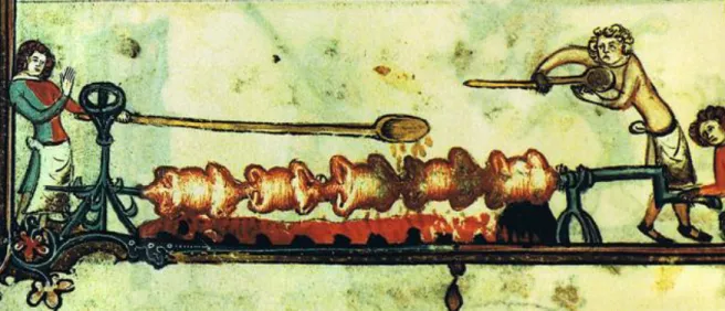
Figure 8 Illuminated image that depicts three persons grilling chickens, in MS Bodley 264, Bodleian Library, Oxford, Archival nr. 2464, f. 170v © Oxford University
21 was enriched with new food stuffs, but in contrast, so many political and social changes brought crisis and shortage.
The basis of the diet of Iberian Peninsula during the middle ages did not change from the one in ancient times, since the composition of the diet, as in the entire Mediterranean basin, had cereals from template climates as the main source of carbohydrates. Among these, wheat was the favorite and had a strong social class significance. The lower classes did not usually ate wheat (Triticum spp.), so they had to drew on other cereals such as sorghum (Sorghum spp.), barley (Hordeum vulgare), rye (Secale cereale) and millet (Panicum miliaceum). In southern Portugal, the consumption of rye was almost zero, since this cereal usually prefers colder and more humid environments. The subsistence of the common population in the Christian kingdoms used to be based on what was left over from what was not taxed by the feudal lord, therefore, food such as wheat –a cereal that requires a lot of work to process it and usually contributes less grains per plant compared to other cereals – was practically restricted for the majority. In contrast, millet was one of the few food stuffs that were not taxed by the lord, therefore it was very popular among the lower classes of the Christian kingdoms; while the evidence of millet carpological remains in Islamic medieval sites is very scarce (Peña-Chocarro, Pérez Jordá, et al. 2019). Besides this, millet has the characteristic of being a plant that resists well in more extreme climates, is easier to harvest and can be easier to store (MacKinnon 2015). Meanwhile, sorghum was more widespread among Islamic populations than among Christian ones. This may be due to the fact that sorghum in Al-Andalus was cultivated by tradition along with wheat and barley (García Sánchez 1983). Another cereal widely consumed in Andalusian society was rice, introduced to the peninsula during the emirate or caliphate period and that was adopted by Christians several centuries later (Stanislawski 1963, García Sánchez 1983).
One of the most popular foods, that its popularity even remains to this day, were pulses. They were consumed daily, being the main source of protein among the lower classes. Its abundance was, partly, through agricultural practices of crop rotation; pulses were planted in large quantities in order to fix nitrogen in the soil with the objective of balance its nutrients. The carpological remains evidence the consumption of peas (Pisum sativum), chickpeas (Cicer arietinum), broad beans (Vicia faba), lentils (Lens culinaris), and bitter vetch (Vicia
22 ervilia) in all Portugal, both in Christian and in Muslim medieval populations (Peña-Chocarro, Pérez Jordá, et al. 2019).
Another source of protein that was common were nuts, which, thanks to irrigation systems, its cultivation was quite widespread. One nut, which its consumption shows precariousness in a population is acorn (Quercus ilex), because it was used, in times of prosperity, to feed the pigs to give their meat a good flavor; this practice is maintained nowadays in both Portugal and Spain through the production of Iberian ham. But, during times of famine the acorns were ground together with other roots to make bread flour (Curto, et al. 2019).
Fruits were perhaps one of the most contrasting aspects between Andalusian and Christian societies, since in Al-Andalus their consumption, variety and commercialization were extended geographically and socially. There is evidence of this in the archaeological and historical records. In contrast, populations ruled by the Christian kingdoms stigmatized their consumption. This stigmatization was based on faith, because fruit was associated with the primal sin of humanity, according to the myth of Adam and Eve (MacKinnon 2015).
The consumption of vegetables in Al-Andalus society was quite widespread in all social classes, while among Christians, vegetables were associated with the lower classes, since among the upper ones the consumption of meat was the core of their diet. The lower classes cultivated the lands of the lord, but the subsistence of the peasantry was not only based on what was produced on these lands, but their food was complemented by products grown in small plots or orchards that were outside each house. The existence of orchards dates from pre-medieval times; however, the importance of these increased, due to the aforementioned policies from part of the feudal lords. Also, this form of cultivation required a unique type of territorial organization that is mostly present in populations belonging to the Christian kingdoms (Peña-Chocarro and Pérez-Jordá, Los estudios carpológicos en la Peninsula Ibérica: un estado de la cuestión 2018).
Among the products grown in these spaces were fruit trees of different types such as apple trees (Malus domestica), peaches (Prunus persica) and plums (Prunus subg. Prunus); assorted vegetables such as celery (Apium graveolens), carrot (Daucus carota), escarole lettuce (Lactuca sativa longifolia); medicinal plants such as chamomile (Chamaemelum
23 nobile); aromatic herbs such as oregano (Origanum vulgare), mustard (Sinapis spp.), coriander (Coriandrum sativum), and even, dye plants such as weld (Reseda luteola) and common madder (Rubia cordifolia) (Peña-Chocarro and Pérez-Jordá, Los estudios carpológicos en la Peninsula Ibérica: un estado de la cuestión 2018).
In contrast to this, the ruled populations, whether under the Emirate, Caliphate or any of the Muslim political entities that existed in the region, enjoyed a very different organization. Under these governments the territory was transformed, and trended to join in denser communities, thanks to the surplus food, and, for this reason, the importance of the orchards had a secondary role. This is due to the introduction of new agricultural irrigation technologies such as the Noria (a hydropowered machine used to lift water) and the Qanat (a gently sloping underground channel to transport water). These implementations caused agriculture to pass from extensive to intensive. According to Malpica Cuello (2012, 218): Thanks to the more or less permanent irrigation, we have a type of agriculture in which monoculture is not present, but a polyculture, a clear indication that it is managed by a peasantry that seeks its self-supply. But this is surpassed by its productive capacity.
Among the fatty sources that were consumed, the most popular, as in the entire Mediterranean basin, was olive oil. In the Algarve and Alentejo its production was regular and constant in both Christian and Islamic sites. Among Christians another fatty element used was pork lard. This culinary element was used even in regions with abundant olive oil production. This is possible to appreciate even today in all Iberian gastronomy.
As for protein sources, perhaps the most consumed were pulses as previously mentioned. Among the livestock animals, the most common and valuable were sheep (Ovis aries) mainly for their wool and after for its milk. The upper classes used to eat lamb meat, and unweaned lamb was considered a delicacy, while the lower classes only consumed mutton when the sheeps were old or their productivity had decreased (MacKinnon 2015). Even more common than sheep were chickens (Gallus gallus dom.), that were more affordable and were mainly raised for their eggs. Between the Christians the consumption of pig (Sus scrofa dom.) was quite extended and, in some areas, it was the second livestock animal that was eaten the most, while in Muslim ruled communities its consumption was lower. This changed dramatically when Muslim and Jewish communities were converted
24 during the reconquest process, in which even inspectors visited homes to make sure that the new Christians had pork products and breed pigs (MacKinnon 2015). Another livestock animal that its consumption was quite widespread in Algarve were goats (Capra hircus) (Valente and Garcia, Food in times of Conflict: Zooarchaeology from Largo da Fortaleza in Medieval Cacela-a-Velha (Algarve, Portugal) 2017), which both societies ate quite regularly and, on the other hand, cows were consumed far much less, since these animals were sometimes not even used for milk production, but for traction and as fertilizers (MacKinnon 2015). Among marine resources, the Christians were the ones that consume them the most. Fish was a symbol of Christianity and the clergy encourage its consumption, since they considered it as a pure meat because of its color, and because of the Christian tradition that said that Jesus Christ was a fisher. However, the consumption of fresh fish was affordable only for the upper classes, while the lower classes only consumed salt-cured fish. In the 11th century in the Basque Country, the cured cod (Bacalhao in Portuguese) market would be established, whose commercialization would spread throughout the Peninsula.
With the production of cured fish, the spice trade exploded, since spices were used to hide its strong taste. At that time the spices were introduced by the Muslims many centuries before. In fact, in Muslim archaeological contexts in comparison with the Christian ones, it is common to find evidence of spices such as cloves (Syzygium aromaticum), pepper (Piper nigrum), coriander seeds (Coriandrum sativum), cardamom (Elettaria cardamomum) and mustard (Sinapis spp.) among the carpological remains (Peña-Chocarro, Pérez Jordá, et al. 2019). The latter became very popular in the Christian community. Its seeds were ground together with salt and vinegar to form a paste which was used to decrease the taste of cured fish, while its leaves were used as fodder. “For the Medieval kitchen the mustard, with its cross-shaped flowers and symbolic seed, was culinarily, theologically, and medicinally important” (MacKinnon 2015, 72).
25
2.3 Archaeological Context
The fortification of Cacela was located in medieval times where the delta of the Guadiana river and where the river of Faro found each other; nonetheless, nowadays the river of Faro has become part of the lagoon of Ria Formosa. Cacela was a strategic port for navigation for the ships that wanted to access the city of Faro from east or for those that wanted to navigate through the Guadiana River. The fortification existed, at least, from the 10th century, although it underwent alterations in the following centuries (Tété Garcia 2015).
The first archaeological intervention in Cacela-a-Velha was done in 1990 because of an emergency intervention. The call for this intervention was due to the fact that a roman oven was discovered when some people were doing trenches for apple tree cultivation. After, in 1998 it was discovered the old Islamic quartier of Poço Antigo. The archaeological intervention was sponsored by the municipality of Vila Real do Santo Antonio. In the process participated the associations of: “Archeological Field of Mertola” (CAM by its Portuguese acronym), the Commission for the Coordination of the region of Algarve (CCDRA by its Portuguese acronym) and the Natural Park of Ria Formosa (PNRF by its Portuguese acronym).
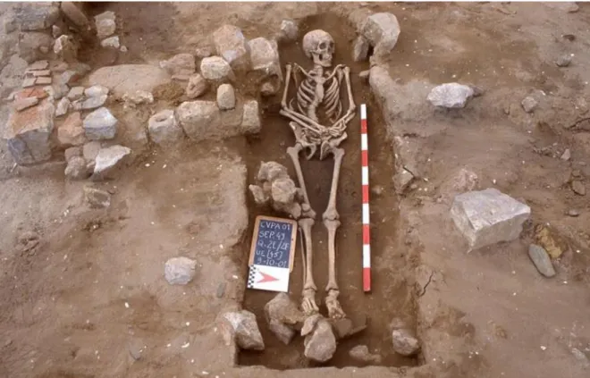
The direction of the archaeological excavation was in charge of Susana Goméz and Alicia Candón of the CAM. This intervention was carried out in two campaigns of 15 and 30 days, adding up a total of forty-five days of work. A medieval Christian sepulchral set was discovered on abandoned constructions that belong to the end of the Almohad period. The medieval necropolis of Cacela was located outside the fortification, near to a stream that passes through the eastern limits of the town, and it was located on an Islamic quartier. It is believed that the fact that the Christian burials were placed there could mean a sort of symbolic victory over the Al-Andalus. Situations like this one have been found in Mértola, Silves and Palmela (Tété Garcia 2015). The label of “Poço Antigo”, that in English means old well, was given because the local inhabitants of Cacela told the archaeologists that in the past, an old well for the supply of drinking water for the town was situated in that area.
In 2001, a new archaeological excavation was carried out at the site of Poço Antigo. The task was extended to the Institute of Anthropology of the University of Coimbra, with
26 Francisco Curate being responsible for the archaeological work. The archaeological excavation was carried out in two campaigns of 75 days each, with the total duration of four months and a half. The first campaign began on May 14 and ended on July 31; nevertheless, because of the Necropolis extended in all the area of the Islamic quartier the excavation was extended till the 9th of December of that same year.
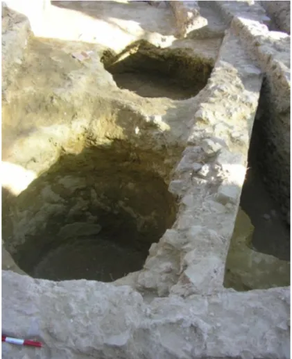
Three years later (2004), the Cacela Heritage Information and Research Center (CIIPC from its acronym in portuguese), in the framework of a project financed by the European Union, promoted the archaeological excavation in the fortification of Cacela (Largo da Fortaleza). In 2007 the CIIPC promoted new archaeological works, reason why it was possible to expand the excavation in the Largo de Fortaleza (see Figure 9). The campaign was held between May and August. Silos were discovered (see Figure 10), some of reasonable dimensions, but it was not possible to reach the bottom of the structures, that were full of medieval rubble (Tété Garcia 2015).
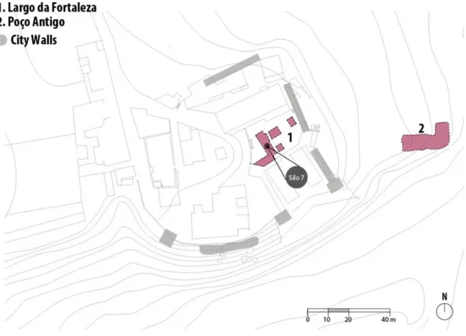
Figure 9 Map of Cacela-a-Velha showing the excavation areas in red. The old walls of the town are depicted in grey. Adapted from (Tété Garcia 2015).
27 In this campaign 81 stratigraphic units were registered and 20 bags (20x45 cm) collected with ceramics, fauna, malacology and glass. The malacofauna was classified in the Archeology laboratory of the University of Algarve, under the guidance of the professor specialized in Archaeozoology: Maria João Valente.
Silo 7 probably was built in the 12th century, during the Almohad period, with purpose of being used as a place to storage cereals in case of possible sieges. Afterwards, the Silo 7 was used as a garbage dump during the first years after the Christian conquest, period that this study concerns. It is possible that due to this use type, the content of the Silo was a mixture between materials from Islamic and from Christian occupation (Valente and Garcia, Food in times of Conflict: Zooarchaeology from Largo da Fortaleza in Medieval Cacela-a-Velha (Algarve, Portugal) 2017).
Figure 10 Silos 3 and 7 during the excavations of 2007. Photo taken from (Tété Garcia 2015).