Rev. bras. oceanogr., 47(1):1-10, 1999
Shallow seismic reflectors and upper Quaternary
sea levei changes
in the Ubatuba region, São Paulo State, Southeastern Brazil*
Michel Michaelovitch de Mahiques1.. & Luis Antonio Pereira de Souza2
lInstituto Oceanográfico da Universidade de São Paulo (Caixa Postal 66149, 05315-970 São Paulo, SP, Brasil)
2Institutode Pesquisas Tecnológicas de São Paulo Divisão de Geologia
(05508-901 São Paulo, SP, Brasil)
.
Abstract The relationship between shaUow seismic lIDits and Quatemary sea leveI changes in Southeastem Brazil is based on boomer profiles aild core data ftom the Ubatuba region, northem São Paulo coast. In Flamengo and Palmas bays, the interpretation of seismic lines revealed the occurrence of four sedimentary units, separated by regionally correlated reflectors. The upper two lIDits correspond to Late Pleistocene and Holocene deposits. The lowermost sedimentary units were correlated to the older Quatemary transgressive events. These deposits, which have not yet been described for this area, can present1ybe fOlIDdon the Rio Grande do Sul coastal plain. In the Boqueirão Strait, two erosional events in the sedimentary strata have been associated with the Cananéia (maximum at 120,000 yr. B.P.) and Santos (maximum at 5,100 yr. B.P.) sea-level rise events..
Resumo: A partir de registros sísmicos, obtidos por "boomer" e dados de um testemunho, foi estabelecida uma relação entre lIDidadessísmicas rasas e variações relativas do nível do mar no Quatemário, na região de Ubatuba, litoral norte do Estado de São Paulo. A interpretação das linhas sísmicas revelou a ocorrência de quatro lIDidades sísmicas, associadas a seqüências sedimentares, separadas por refletores sísmicos de expressão regional. As duas unidades superiores correspondem a depósitos do Pleistoceno Superior e Holoceno, e encontram correspondência em outras áreas do planeta. Na região do Boqueirão, dois eventos erosivos são associados com os últimos eventos de subida do nível do mar. As unidades sedimentares inferiores são correlacionáveis a eventos transgressivos mais antigos, que não haviam sido ainda referidos para a área.·
Descriptors:Reflection seismics, Coastal region, Sea-level changes, Ubatuba, São Paulo.·
Descritores: Sísmica de reflexão, Região costeira, Variações do nível do mar, Ubatuba, São Paulo.Introduction its maximum at approximately 120,000 yr. BP and
reached a maximum of 8.0 m above the present sea leveI. The other, named Santos, had its maximum at 5,100 yr. BP and reached a maximum of 5.0 m above the present sea leveI (Suguio & Martin 1978). These events were separated by a regressive event, correlated to the Wibm-Wisconsin (maximum at l8,000-yr. BP), when the sea levei dropped approximately 130 meters below the leveI present on the Southeastern Brazilian margin (Kowsmann & Costa, 1974; 1979). On the Southeastern Brazilian In Southeastern Brazil, at least two
Quaternary sea levei rise events can be recognised in the coastal region. One, named Cananéia, presented
(*) Supported by the Fundação de Amparo à Pesquisa do Estado de São Paulo (FAPESP) - Processo 88/0109-9 and 89/2159-2.
(**) Researcher CNPq - Brazil
2 Rev. bras. oceanogr.; 47(1), 1999
coastal plains, despite the existence of several Quatemary sea-level curve§,that,are based on she1J,.:,.. inidden (tlsambaquistl) atÍa Vermetidae positions; especially for the last 7;'000 years (Suguio et al, 1982; Martin et al, 1985), little information is available on the buried deposits of coastal submerged
areas. lhis lack of data makes it difficult to
establish the sedimentary evolution models for the
Quatemary. For this reason, the study of the
Holocene sedimentary sequences in enclosed
embayments may provide a more reliable set of information on the evolution of the coastal area (Mahiques, 1992; Silva & Baptista Neto, 1992*). In a restricted area of the northem coast of São Paulo State, seismic sequences may be recognised that ean be correlated to reIative sea leveI change events and interpreted in terms of models of Quatemary coastal change.
Study area
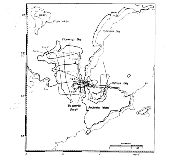
lhe study area comprises Flamengo and Palmas bays, two smalJ and shallow (0-20 m) semi-enclosed marine environrnents, that are connected by a strait, 35 m deep and 500 m wide, called Boqueirão da Ilha Anchieta (Fig. I).
Precambrian high-rank metamorphic rocks of the Complexo Costeiro unit and granitic bodies that form the Serra do Mar mountain chain dominate the northern coast of São Paulo State. Between the projections of the crystalline rocks into the sea there are small Quaternary coastal plains. Small rivers forrn the fluvial system with a dendritic to sub-paralleI drainage pattem (SICCT, 1981).
6' 4' 45-2'
Fig. 1. Location ofthe study area (bathymetric !ines in meters), position of the core collected in Flamengo Bay and seismic survey grid showing location offigures 2 to 5.
(*) Silva, M, A M & Baptista Neto, 1. A. 1992. Caracterização do tômbo10 da Praia de Charitas - Enseada de Jurujuba (Baía de Guanabara). In: CONGRESSO BRASILEIRO DE GEOLOGIA, 37, São Paulo, 1992. Resumos Expandidos. São Paulo, SBG, 1:96-97.
MAHIQUES & SOUZA: Seismic reflectors, Ubatuba~ - ~
rich in organic carbon (up to 2.5% Corg) and poor in calcium carbonate (commonly less than 30010CaC03) (Mahiques, 1995).
In Flamengo Bay, the sediments are transported by a clockwise circulation system, which begins with the entrance of oceanic water along the westernmost part ofthe bay's mouth. SW- NE or NE-SW wave-driven CUITentvelocities can increase during the passage through the Boqueirão Strait (Magliocca & Kutner, 1965) and deviate the water flow, in the easternmost part ofthe bay.
The Boqueirão Strait is one of the several coastal depressions present on the southeastern coast of Brazil. The origin of Boqueirão Strait is probably related to the ancient drainage systems that developed during the upper Quaternary low sea leveI periods (Almeida, 1964), associated to tectonic structures. On the other hand its evolution may have been associated to the erosion by tidal currents during the Santos sea leveI rise event (Mahiqueset al., 1989*).
The circulation in the Boqueirão Strait as well as that in Palmas Bay is strongly dependent on wave action and wind-driven currents, which are determined by the atmospheric conditions in the Southeastern region of Brazil (Tessler, 1988). In general, the passage of cold ftonts leads to the
generation of strong SW
-
NE currents that reach upto 80 cm/sec in the Boqueirão area. In normal
situations, NE
-
SW currents prevail there.Seismic Sorvey and coring
Approximately 56.8 km of seismic profiles (Fig. 1) were collected on board the RN. "Albacora" of the Instituto Oceanográfico of the Universidade de São Paulo. The seismic source was a HUNTEC Hydrossonde M2-A, ftom the Instituto de Pesquisas Tecnológicas do Estado de São Paulo. The sound source utilised a band ftequency between 900 and 9500 Hz (with a peak at 5000 Hz) and an energy output of about 150joules per pulse.
Navigational control was provided by a GEOTRON BT-100 Minirange system, ftom the Banco de Equipamentos Geofisicos do Programa de Geologia e Geofisica Marinha (BEG-PGGM). Relative positions were obtained every 2 minutes, at a speed of approximately 3 knots.
A 490-em long vibracore was collected ftom the inner part of Flamengo Bay (Fig. 1), in order to obtain dating material and to identify the lithologies
of the uppermost sedimentary column. Mollusc
shells, found in living position were dated by C14
(*) ~iques, M. M; Furtado, V. V. & Tessler, M. G. 1989. Origin and'evolution of isolated depressions on the coastal region of Silo Paulo and Rio de Janeiro states. In: lNTERNATlONAL SYMPOSIUM ON GLOBAL CHANGES IN SOUTH AMERICA DURING THE QUATERNARY: PAST-PRESENT-FUTURE. São Paulo, 1989. Abstracts. São Paulo, ABEQUA-INQUA, 1:285-288.
3
(AMS technique) by the Beta Analytic Laboratories (USA).
Results
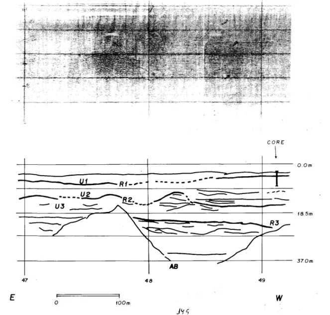
The analysis of seismic profiles reveals the existence of four units, separated by three regionally correlated reflectors. Figure 2 shows a complete succession of sedimentary units found in the area.
The reflector RI defines the uppermost sequence (Unit VI). It is fairly flat and it exhibits conspicuous changes in internal reflection pattern, running parallel in the outer part of the bay and being transparent in the inner parto In most of Boqueirão
area VI as well as deeper units are completely
eroded.
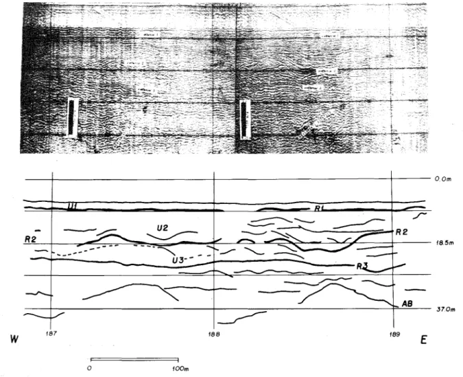
The second unit (Unit V2) overlies an
irregular erosive reflector (R2). Cut-and-fi11, chaotic structures and dipping internal reflectors (Fig. 3) characterise the basal part of the unit Its topmost part is mainly characterised by transparent and para11el reflection patterns. In the inner parts of the bay, R2 and R3 onlap the acoustic basement.
Reflector R3 separates the deepest
sedimentary units (U3 andV4) and its non erosive shape characterises it. Vnit V3 and the uppermost sequence ofV4 present a high variability of internal reflection patterns.
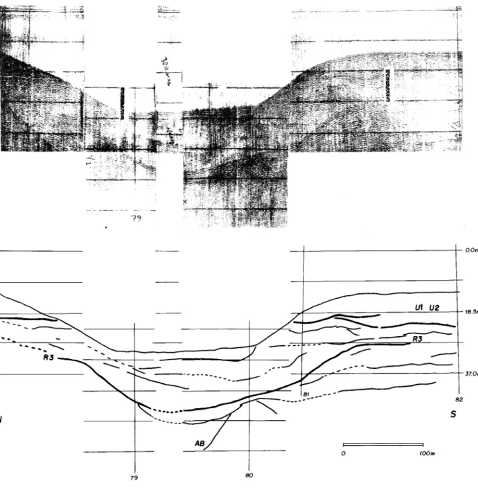
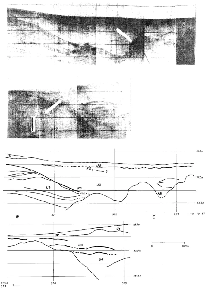
The seismic records of Boqueirão Strait (Figs 4 and 5) reveal two features of erosional truncations. The first feature corresponds to reflector R3 that has a high reflection coefficient, and cuts across two units of deeper sedimentary units (Fig. 4). Reflectors RI and R2 are truncated by the present surface. One important characteristic related to this feature is that the deepest pomon of the Boqueirão Strait presents a conspicuous depositional sequence, indicated by a divergent fi11facies. On the other hand, the flanks of the Boqueirão are clearly erosional.
The whole sedimentary section overlies the acoustic basement formed by the granitic and gneissic rocks of the Complexo Costeiro, which is very irregular and presents high relief.
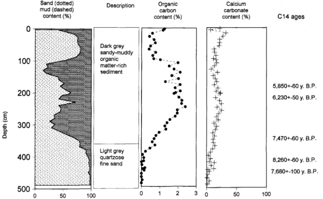
The core collected in the inneI' part of Flamengo Bay (Fig. 6) presents a sharp contact, situated at 360 em depth, which separates an uppermost dark grey sandy mud lithofacies, rich in organic carbon (up to 20 mg/g org C), and with variable amounts of plant debris and calcium carbonate, ftom lowermost light grey quartzose sand facies, very poor in organic carbon and calcium
carbonate. These basal sediments present
4 Rev. bras. oceanogr., 47(1), 1999
f
Rf-"'-CORE
t
O.Om
---
--- -.".
---47
E
o 1100m
18.5m
370m
48 49
w
Fig. 2. a) Seismic line and, b) Interpretation ofthe complete section ofseismic sequences and reflectors, found in the northwesternrnost part ofFlamengo Bay.
A Cl4 dating provided an age of7470 1:
60-yr. BP for a shell collected immediately below the contact between the two lithofacies.
Discussion
Reflector RI can be easily corre1ated to the sharp mud-sand contact found in the core, which was collected in the northwesternmost part of Flamengo Bay. The lower sequence observed in this core is of quartzose sandy strata, withCa/lichirus majortubes, but poor in bioclastic compounds. According to Duleba (1993) this sand sequence is almost sterile in terms of foraminifer content and was interpreted as being a beach deposit. The upper sequence, which corresponds to Vnit VI, is composed of marine muddy-sand sediments, with variable amounts of shell fTagments and plant debris, rich in organic
carbon, that are representative of the low energy conditions that prevail presently in the area. Foraminiferal datá show a progressive increase of density and diversity up to the intermediate part of the upper sequence (Duleba, 1993), leading to a correspondence of the basal part of Vnit VI to the submergence Phase I described by Dominguez & Wanless (1991) in the Doce River coastal deposits.
Thus, sediments of Vnit VI correspond to the
holocenic marine sedimentation of the area, which could have started at approximately 7,500 yr. BP.
Reflector R2 could be interpreted as an erosional surface developed after the maximum ofthe Cananéia Transgression up to the time of the ma}(Ímumlate Pleistocene regression, which occurred
at 18,000 yr. B.P. Thus, Vnit V2 probably
MAHIQUES & SOUZA: Seismic reflectors, Ubatuba 5
O.Om
R2
U2
~
~ - -""""
U3--
_J
"--18.Sm
w
187o
I 100m
R2
37.0m
188 189
E
Fig. 3. a) Seismicline and, b) Interpretation ofthe complete section of seismic sequences and reflectors, found in the easternmost part ofFlamengo Bay.
2 (Inman, 1983; Johnson, 1983; Ronen, 1983;
Giresse, 1989).' .
Units Ul and U2 can be correlated
respectively the upper Holoceneand uppermost
PleistÓCelleunits already described worldwide (Saito, 1989; Bodur & Ergin, 1992; Marssetet ai., 1996).
Aeeording to the evolutionary model, proposed by Suguio & Martin (1978), for the coast of the State of São Paulo, we can interpret units U3 and U4 as representing the Pleistocene sequence correlated to the Cananéia deposits or even to older sequences. R3 could represent either an erosional surfaee, as an abrupt change in the sedimentation pattern, as for RI.
The analysis of Boqueirão Strait profiles reveals the occurrence of two important erosional events, indicated by the shape of the present bottom surmce and by reflector R3. The reflector R3 shows a pattern that is similar to the present surfaee bottom. Thus, we may assume that the bottom dynamie processes that were responsible for the development of R3 were the same as those, whieh maintain the bottom shape of the Boqueirão as it is at present. Admitting that the scour of the Boqueirão is eorrelated to high sea leveI, we ean assume that R3
was.developed during a high sea leveI period, possibly eorrelated to the maximum of the Cananéia event (ca. 120,000 yr. B.P.), when the sea leveI reached up to 8 meters above the present sea leveI.
Despite their absence ftom the emerged coastal deposits, at least two sedimentary units ean be identified below reflector R3 (U4 and underlying
deposits) and above the acoustic basement.
Assuming that U4 corresponds to the transgressive deposits correlated to the Cananéia event, we can associate the lowermost sedimentary sequences to older transgressive-regressive deposits. In the Rio Grande do Sul coastal pIain (southward of the study area), two other Pleistocene sedimentary sequences are found (Longet ai., 1989*), which were associated with isotopie stages 8 and 10 or 6 and 8. Thus, we may correlate the lowermost deposits of the study area to one of these sequences.
6 Rev. bras. oceanogr., 47(1), 1999
O.Om
N
ut U2
18.5m
" -,
-
---.~
--37.0m
825
AS
100m
79 80
MAHIQUES & SOUZA: Seismic refIectors, Ubatuba 7
18.5m
--- -
.-...-37.0m
55.5m
w
57.1 57.2 57.3 _ TO 57.4E
f8.5m
UI
UJ
-...---...
-_.~---o 100m
370m
55.5m
FRON
573
-574
57.5Fig. 5. a) Sismic line along Boqueirão da llha Ânchieta Strait and, b) Interpretation showing the truncation
8
Sand(dotted) mud (dashed) eontent (%)
Deseription
Rev. bras. oceanogr., 47(1), 1999
Organie earbon eontent (%)
o
100
500O 50 100 O 2
Caleium earbonate
eontent (%) C14ages
5,850+-60 y. B.P. 6,230+-50 y. B.P.
7,470+-60 y. B.P.
8,260+-60 y. B.P. 7,680+-100 y. B.P.
3 O 50 100
Fig. 6. Lithologicaldescription, sedimentological and 14Cage data ITomthe core collected in the northwestern part ofFlamengo bay.
The uppermost two units (VI and U2) are correlated to the upper Holocene and uppermost Pleistocene deposits identified worldwide. Part af the upper sediments are corre1atedto the submergence Phase I, described for Rio Doce deposits. The deposition of Holocene marine sediments in the area started ca. 7,500 yc.BP
The sequence of Quaternary events and their eorrelation with seismie reflectors and units is summarized in Table I.
Conclusions
In the northern eoastal region af São Paulo State, Brazil, four seismie units ean be recognised.
Table I. Sequence of Quaternary events and their correlation with seismic retlectors and units identified in the area.
.__r . Darkgrey
I
:\
sandy-muddy
{.--organie
matter-rieh ...-- c-.
sediment .,..::.
- -e ."--;e.. .,,-e
..
.-.
01
.
-!
.í
Lightgrey
.
..
quartzose
li finesand,
200:[
.c 300 ã. CD o 400REFLECTOR SEISMIC INTERPRETA TION ISOTOPIC AGE INDICATION CORRELATION.
UNIT STAGE
(YEARS B.P.)
Present surfare Erosional in the tlanks of Present Batbimetry and
Boqueirão Straít, seismíc.
depositíonal in Flamengo and Palmas bays
U1 Hígh stand, shallow marine 1 From 7,500 to Seismíc and core data. Dominguez &
deposits. BasaI sedirnents p'esent Wanless (1991); Saito
correspond to a (1989); Bodur&
transgressíve phase. Ergin (1992); Marsset
et a/. (1996)
RI Transgressive Holocene Between 7,500 Core data
suRare and 5,500
U2 Alluvíal to coasta1deposits 2,3,4 ca. 120,000to Seísmíc data. Saito (1989); Bodur &
(low stand to transgressive 7,5000 Ergin (1992); Marsset
deposits) et 01.(1996)
R2 Sea-Ievel maximum Post 120,000 Seismíc data Inrnan (1983);
lo-nng(erosive) Johnson (1983);
Gíressei1989)
U3 Shallow marine to coastal 5
-
120,000 Suguío & Martín(Cananéia Transgression) (1978)
to aIJuvíal dePosits.
R3 Transgressive upper Before 120,000 Seismíc data
Pleistocene surfare
U4 TransJUessivedeposits Seísmíc data Longet 01.(1989)
MAHIQUES & SOUZA: Seismic reflectors, Ubatuba 9
The base of Unit 2, colTesponding to Retlector R2, represents the surface generated during thê sea-level regression, COlTespondingto the WÜ11n-Wisconsin glacial event
Two scour events, identified in the seismic records in the Boqueirão area, are associated with high sea leveI phases, idenÍified with the Cananéia and Santos sea leveI rise events.
Finally, at least one sedimentary sequence, which can be cOlTelatedto older Pleistocene events that have not been described before in the area, has beên identified.
Acknowledgements
We wish to thank to Dr. Alberto Garcia Figueiredo Jr. ofthe LAGEMAR ofthe Universidade Federal Fluminense and Drs Moysés Gonsalez Tessler and Silvia Helena de Mello e Souza of the Instituto Oceanográfico da Universidade de São Paulo. To Dr. Jean-Claude Faugêres fi-om the Université de Bordeaux I, France, for the critical review. Our thanks are also due to Mr. Pierre Alexander Michaelovitch and Mrs. Marta Stefan for the illustrations and to Mr. Arthur Boorne for the revision of the text
References
Almeida, F. F. M. 1964. Os fimdamentos geológicos do relevo paulista. In: Azevedo, A. 00. Brasil, a terra e o homem. São Paulo, Companhia Editora Nacional. p.55-120.
Bodur, M N. & Ergin, M 1992. Holocene
sedimentation pattems and bedforms in the wave-cUlTent-dominatOOnearshore waters of eastern Mersin Bay (Eastem Mediterranean). Mar. Geol.,
108(1):73-93.
Dominguez,1. M. L. & Wanless, H. R 1991. Facies architecture of a falling sea-level strandplain, Doce River coast, Brazil. Spec. Publ. Boston, Blacknell Scientific. Publ., 14:259-281.
Duleba, W. 1993. Variações nas associações de foraminiferos ao longo da coluna sedimentar da Enseada do Flamengo, Ubatuba, SP. Dissertação de mestrado. Universidade de São Paulo, Instituto Oceanográfico, 21Op.
Giresse, P. 1989. Quaternary sea-level changes on the Atlantic coast of Afi-ica. In: Tooley, M. 1. & Shennan, I. eds. Sea-Ievel changes. Oxford, Basil Blackwell. p. 249-275.
Inman, D. L. 1983. Application of coastal dynamics to the reconstruction of paleocoastlines in the Vicinity of La Jolla, California. In: Masters, P. M. & Fleming, N. C. eds. Quaternary coastlines and marine archaeology: towards the prehistory of land bridges and continental shelves. London, Academic Press. p. 1-49.
Johnson, D. L. 1983. The California continental
borderland: landbridges, watergaps and biotic dispersals. In: Masters, P. M. & Fleming, N. C. eds Quatemary coastlines and marine archaeology: towárds the prehistory of land bridges and continental shelves. London, Academic Press. p. 481-527.
Kowsmann, R O. & Costa, M P. de A. 1974. Paleolinhas de costa na plataforma continental das
regiões sul e norte brasileiras. Revta bras.
Geociênc.,4(4):215:222.
Kowsmann, R O. & Costa, M P. de A. 1979.
Evidence of late quatemary sea leveI stillstands on
the Upper Brazilian continental margin: a
synthesis. In: INTERNATIONAL SYMPOSIUM ON COASTAL EVOLUTION DURING THE QUATERNARY. São Paulo, 1978. Proceedings. São Paulo, INQUA. p.170-192.
Magliocca, A. & Kutner, A. S. 1965. Sedimentos de fimdo da Enseada do Flamengo. Contrções Inst. oceanogr. Univ. S Paulo, sér. Oceanogr. fis., (8):1-15.
Mahiques, M. M 1992. Variações temporais na
sedimentação quaternária dos embaiamentos da região de Ubatuba, Estado de São Paulo. Tese de doutorado, Universidade de São Paulo, Instituto Oceanográfico. 2v.
Mahiques, M. M 1995. Sedimentação atual nos
embaiamentos da região de Ubatuba, Estado de São Paulo. Bolm Inst. oceanogr., S Paulo, 43(2):111-122.
Marsset, T.; Xia, D.; Berne, S.; Liu, Z.; Bourillet, J. F. & Wang, K. 1996. Stratigraphy and sedimentary environments during the Late Quatemary, in the eastern Bohai Sea (North China Platform). Mar. Geol.,135(1-4):97-114.
10 Rev. bras. oceanogr., 47(1), 1999
Ronen, A 1983. Late quatemary sea levels inferred from coastal stratigraphy and archeology in Israel. In: Masters, P. M. & Fleming, N. C. eds Quatemary coastlines and marine archaeology: towards the prehistory of land bridges and continental shelves. London, Academic Press. p. 121-134.
Saito, Y. 1989. Late Pleistocene coastal sediments, drainage pattems and sand ridge systemson the shelf ofI Sendai, Northeast Japan. Mar. Geol., 89(3/4):229-244.
SICCT- Secretariada Indústria,Comércio,Ciênciae
Tecnologia. 1981. Mapa geológico do Estado de
São Paulo. São Paulo,
SICCT/PRÓ-MINÉRlO/PROMOCET. 2 v.
Suguio, K..& Martin, L. 1979. Formações quatemárias marinhas do litoral paulista e sul-fluminense. In: INTERNATIONAL SYMPOSIUM ON COASTAL
EVOLUfION IN THE QUATERNARY. São
Paulo, 1978. Spec. Publ. São Paulo, INQUA. 55p.
Suguio, K..; Cruz, O.; Muehe, D. & Amador, E. S. 1982. Coastline of the states of Rio de Janeiro and
São Paulo. Rio de Janeiro, Comission on the
Coastal Environment. CCE Field Trip -
8/9-15/1982.5Op.
Tessler, M. G. 1988. Dinâmica sedimentar quatemária
no litoral sul paulista. Tese de doutorado.
Universidade de São Paulo, Instituto de
Geociências. 276p.