1
POPULATION SUPPORT FOR MAKING AN URBAN AREA AND ITS
TRANSPORT SYSTEM RESILIENT AGAINST FLOODING
APOIO DA POPULAÇÃO PARA TORNAR UMA ÁREA URBANA E O SISTEMA DETRANSPORTE RESILIENTES A INUNDAÇÕES
Cilio José Volce1, Daniela de Castro Soares2, Manuela Fontenele Velasco3, Heliana Barbosa Fontenele4, Carlos Alberto
Prado da Silva Junior5
1Universidade Estadual de Londrina. E-mail: [email protected] 2Universidade Estadual de Londrina. E-mail: [email protected]
3Florida International University. E-mail: [email protected] 4Universidade Estadual de Londrina. E-mail: [email protected] 5Universidade Estadual de Londrina. E-mail: [email protected]
ABSTRACT
The main objective of this research was to evaluate the population's support for a project to make resilient an urban area and local transportation system that are subject to flooding. To develop the study, a conceptual project was created that represented a solution to avoid flooding in the aforementioned area. This conceptual project was presented to a group of interviewees for their appraisal. A multiple choice questionnaire was utilized to capture the interviewees' perceptions about the proposal, as well as their opinions about the possibility of financially supporting the project. For this specific case study, the results indicate that the citizens would financially support the project. Yet, this support would be primarily in the form of volunteer work that would need to be converted into monetary resources. Beyond this, the interviewees were able to express their opinions and concerns about the proposal which was presented in the form of a conceptual project.
Keywords: resilient; flooding; urban area; transport system RESUMO
O objetivo principal dessa pesquisa foi avaliar o apoio da população a um projeto que torna resiliente uma área urbana e o sistema de transporte local que estão sujeitos inundações. Para desenvolver o estudo foi criado um projeto conceitual que representava uma solução para evitar as inundações no local de estudo. Esse projeto conceitual foi submetido à apreciação de um grupo de entrevistados. Para captar a percepção desses entrevistados sobre a proposta, bem como a possibilidade de apoio financeiro ao projeto foi utilizado um questionário de múltiplas escolhas. Para o caso específico desse estudo, os resultados indicam que os cidadãos apoiariam financeiramente o projeto. Porém, esse apoio seria, principalmente, na forma de trabalho voluntário que precisaria ser convertido em recursos monetários. Além disso, os entrevistados puderam expressar suas opiniões e preocupações a respeito da proposta apresentada na forma de projeto conceitual.
Palavras-chaves: resiliência; inundação; área urbana; sistema de transporte
1. INTRODUCTION
Due to a series of climate events, badly designed or unfinished hydraulic works, sociopolitical and environmental issues, many urban areas have suffered the consequences of flooding. These floods can cause economic-financial and social damages and reduce mobility and accessibility in various places in a city. Moreover, they can cause losses in real estate, durable, and semi durable goods for populations in general, but especially for those with low income. Additionally, floods cause productivity losses in commercial, industrial, and service sectors. On these questions, there is the possibility of transforming these vulnerable areas into resilient locations. From there, one can generate a better quality
2 of life, reduce generalized costs resulting from flooding, and ensure citizen participation in the solution to these urban problems.
The concept of resilience applied in cities can be understood as a way to reduce or avoid impacts on the lives of the population and urban infrastructure. This way, guaranteeing the reestablishment of normalcy in vulnerable areas as quickly as possible can contribute to achieving more fair and sustainable cities. Therefore, in a scenario where many mayoral administrations do not have the resources necessary to invest in infrastructure construction to manage water resources and guarantee resilience to flooding in urban areas, the objective of this research was to evaluate the financial support of the population in relation to a project that could make an area that suffers from flooding resilient. This support involves participation in decisions and financial support for the project to avoid inundations that occur in a cushioning basin, in the urban area, called Aterro do Lago Igapó II, in the area of Londrina -PR.
To accomplish this, a proposal was made in the form of a conceptual project. This project represented a conceptual solution to increase the volume of the easement basin of the Aterro do Lago Igapó II. This way, there was a possibility of accumulating a larger volume of water when there was an increase of overflow from the main river of the hydrological basin of the study location. This study justifies itself by the necessity of investigating alternatives to improve the city’s recuperative capacity after it suffers strong natural pressures that cause economic and social damages. Beyond that, it seeks to amplify the discussion and knowledge about the concept of resilience applied to cities, on the point of view of damages and homes and for systems that can guarantee accessibility and urban mobility.
2. RESILIENCE: FLOODS AND URBAN MOBILITY
The floods that can occur in the urban area are recurring problems and with difficult solutions. Decina and Brandão (2016) highlight that soil use regulation as a preventative approach can result in more efficient solutions against the effects of inundations. Due to this, these authors argue that it is important to consider drainage of the hydrological basin before the process of occupying the urban area, because this would be possible to plan the compatibility of soil use with the hydrologic cycle in the region.
The last few decades, the concept of resilience in the urban space has been discussed and applied. This way, the consensus appears to be that a resilient urban area would be capable of suffering habitual pressures, natural events or unusual ones provoked by human beings, but during these pressures and after the event is over the region will continue to develop its functions normally or with little social and economic impact.
The various rivers and hydrological basins that are not contained in urban areas can provoke inundations and cause interruptions, for example in transport systems that are in the coverage area for these hydrologic resources. Leobons et al. (2017) highlights that urban resilience applied to transport systems is directly related to mobility and the forms to avoid possible collapses of these systems. These collapses, according to the authors, can be related to the impossibility of movement for people and possessions, and the unfeasibility of promptly resetting the flux of trips.
Because of this, it can be inferred that resilience in transport and mobility systems against interruptions caused by flooding in urban areas can be related to a region’s capacity to accommodate and avoid letting the additional volume of overflow from rivers and streams reach these systems that guarantee movement to people and cargo throughout the city. Due to this, the implementation of infrastructure in strategic locations and ones with recurring flooding problems an guarantee permanent activity for the transport systems, even during events that cause overflow in catchment areas that cut through urban zones.
3 2.1. Catchment basins
An increase in volume of water caused by strong local rains or in regions influenced by catchment areas can provoke floods that complicate or impede the movement of people and goods in various urban areas. This causes socioeconomic difficulties and damages for affected populations. Because of this, according to Leobons et al. (2017) it is necessary to create strategies to maintain mobility in urban transport paths and make resilient areas subject to events that could cause interruptions to the transport systems.
There are at least two types of measures that can be implemented to control and prevent flooding, according to Decina e Brandão (2016): i) structural measures and ii) non-structural methods. The structural methods generally involve engineering works and resulting costs. Now the non-structural or operational methods can comprehend the systems of alert, zoning, insurance against loss of capital, etc. Still according to Decina e Brandão (2016), these measures should be compatible in the urban planning process to avoid the certain and possible socioeconomic losses for a given urban area.
Between the methods considered structural, one can cite the aforementioned catchment basins. According to Nascimento et al. (1999), the utilization of these basins can contribute to reducing the implementation costs of plumbing and macro storm drainage works. Beyond this, when properly implemented and maintained, these basins can reduce pollutants from runoff solid material and enrich the landscape of the urban space through sport and leisure activities.
From the operational point of view, a catchment basin is considered a structural measure. It possesses the function of provisionally storing storm water and sending that water in a controlled wat to a drainage system. Moreover, due to appearing dry or useless for a majority of the time, these basins can be used as areas for leisure and/or sports. Yet, it is important to guarantee their permeability to allow rain water to infiltrate more quickly during rainy days (de Souza Bragança, 2016).
This way, growing urbanization and the inefficiency of urban planning has provoked increasing impermeability in cities’ soils. This generates an increase in surface runoff that causes increasing amounts of flooding due to the diminishing infiltration of rain water. The areas most affected by this flooding are valley floors (Coura e dos Santos, 2016). On the other hand, there are often important transport systems implanted on these valley floors that allow for the generation of interaction between moving people and goods with the city. For the specific circumstance of this research, the location of the study involves the region of a valley floor that includes the aforementioned Aterro do Lago Igapó de Londrina. The region is comprised by diverse transport systems that generate mobility, while still being a space for leisure and sports
2.2. Consequences of the lack of resilience in the urban zone
The urban area or the city space, in the recent decades of the 20th century and in the beginning of the current century, has proved to be the preferred life stage of human beings. According to Jacobs (2011), the city has to be the place where people can satisfy their everyday and specific needs. Still, it is necessary to guarantee permeability for people throughout the urban fabric and the diverse subcultures that live in the different locations of the city. The city of Londrina possesses a couple well-defined commercial and administrative regions, locations for leisure and cultural dissemination, that were inherited from the diverse populations that have constructed this important city in the southern part of Brazil.
On the other hand, the mobility that can guarantee movement through various neighborhoods and regions of the city needs to be better planned and maintained by public managers. An example of this is the region of the Aterro do Lago Igapó which, like many valley floors in other Brazilian cities, has suffered in a recurring way from flooding problems and resulting damages to socioeconomic activities developed in the various properties in that location, much like accessibility and mobility problems due to interruptions to the transport systems that generate interaction with the city.
4 In a study about the region of Lago Igapó, De Bortolo e Fresca (2011) characterizes the location as a public space with functions for practicing sport and leisure, frequented by middle class and upper middle class individuals, as well as around it there are residential and nonresidential properties with big commercial value. These properties attract a large number of people, due to the possibilities of satisfying daily and specific necessities from the point of view of housing, commerce, services, leisure, and relaxation.
According to De Bortolo (2010), it is the state’s role to guarantee and promote, as a public agent, the urban space of the city. This guarantee needs to include the valorization, implementation, manufacturing, and requalification of regions, like for example the Aterro do Lago Igapó II and its surroundings. Yet, according to Larocca et al. (2017), in periods of intense rains, the Aterro do Lago Igapó II and its surroundings have suffered from floods and inundations. According to these authors, the floods and inundations can cause consequences for the urban environment, such as: proliferation of water diseases, if the path of the water is polluted; reduction in commercial property value; damages for road infrastructure (paved roads); loss of vegetation and of landscape quality.
2.3. Consultation and support of the population for projects in the urban area
In Brazil, it is uncommon for the urban population to be consulted about the implementation or modifications of infrastructure in the city environment. Many times, infrastructure in general is implemented or modified without acknowledging with the important role that the residents’ perception could play for the creation or adaptation of the city environment. Participate Melbourne (2017), Ricieri et al. (2017) e Gomes (2018) present the notion of a conceptual project as a tool to establish a dialogue between the public manager and the population in relation to the proposals of implementation and/or improvement of urban transport systems. Jacobs (2011) highlights that a city is an immense laboratory of trial and error, failure and success in respect to urban planning, project, and construction. Still according to this author, there is no way to identify that a solution about to be adopted will work without first knowing the location and the people that will suffer the impacts of what is being proposed.
Another issue that has had a strong impact on the possibility of improvements in the urban area is the scarce resources for projects, construction, and maintenance. Jacobs (2011) relates that volunteer work from residents and their relatives can help in the processes of construction and maintenance in cities. According to Cradock et al. (2018), the population’s support for works to control flooding contributed to make a determinate urban area resilient. This author demonstrated that the support of people was significant and involved, especially those residents that already utilized the installations where there will be infrastructure alterations. Long et al. (2018) developed research to provide evidence that there would be public support for efforts to increase access to drinking water in schools and public parks. This way, it appears that it is possible to voluntarily and financially pledge the local population with proposals to turn urban areas resilient to diverse natural pressures or those provoked by human beings.
3. METHODS
The research was developed with reference to the inundations in the region of the Aterro do Lago Igapó II in the city of Londrina-Paraná. For this, there were analyzed diverse consequences of the floods in the region created to public and private patrimony, and accessibility and mobility of those that use the surroundings of the Aterro do Lago Igapó II to live, work, and practice their recreational activities. For this, a solution was developed to make the infrastructure resilient to inundations or floods in the region of influence of the hydrologic basin of the Ribeirão do Cambé.
To adapt infrastructure in the study location, a proposal was developed in the form of a conceptual project like Participate Melbourne (2017), Ricieri et al. (2017) e Gomes (2018). This
5 conceptual project aimed at increasing the size of the catchment basin of the Aterro do Lago Igapó II. For this, the filled land would have its current elevation lowered a sufficient level to accommodate larger volumes of water due to the increase in flow rate of the Ribeirão do Cambé. This lowering of the elevation of the filled land would be done basically by excavation and reconstituted of the embankment bed. The excavations followed the technical and environmental norms in force in Brazil. Beyond this, all the current equipment for practicing recreational activities would be reinstalled in the new embankment. Other improvements could also be suggested and implemented according to how the conceptual project was evaluated by the community that currently uses the Aterro do Lago Igapó II and by the public managers responsible for the proposal.
After the development of the conceptual project, an electronic questionnaire was created to capture the perception of a sample of the population that lives and frequents the region of the research location. This questionnaire was divided into three parts: i) perception about the developed conceptual project; ii) methods of supporting the project; and iii) information about the socioeconomic profile of those interviewed. Starting with those two tools, three interviewers did 30 interviews during a Thursday during the month of May 2018 during the period of 4:30 p.m. to 6:30 p.m. in the region of the Aterro do Lago Igapó II. This amount of interviews represents 14.5% of the hourly average number of people using the embankment of Lago Igapó. This percent was estimated based on research previously done during a workday and a Sunday. From the count during those days, it was estimated that the average of users of the Aterro do Lago Igapó II is 206 people per hour. In the sequence, this information was organized and analyzed to generate some of the results and conclusions for this study.
4. RESULTS AND DISCUSSIONS
The results of this research are presented in this section according to the following order: characterization of the study location; socioeconomic profile of those interviewed and the responses to the electronic research questionnaire.
4.1. Characterization of the study location
This research was developed in the city of Londrina- Paraná, which according to IBGE Cidades (2017), possesses a population estimated at 558,439 inhabitants. The city suffered from various problems due to flooding during these last eight years and the region of the Aterro do Lago Igapó II was seriously hit. Thus, this region was considered to develop a project that makes it resilient to flooding and consequently does that for the property and transport system. The research location can be classified as mostly residential, but it includes commercial activities and services, such as: gyms; diverse types of offices; bars; restaurants; small retail stores in general and a medium-sized hospital.
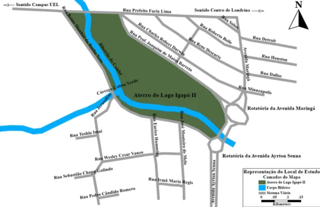
In this area, there is installed equipment for practicing sports and leisure activities. The surrounding of the embankment is bound by Rua Professor Joaquim de Matos Barreto and Rua Bento Munhoz da Rocha Neto, the two rotatories that link the avenues Maringá and Ayrton Senna and Rua Prefeito Faria Lima. That road is an important link between the center of the city and the campus of Londrina State University (UEL). This system of routes, when interrupted by flooding, reduces accessibility and mobility for people who live and travel around the Aterro do Lago Igapó II. In Figure 1, there is a representation of the research location.
6 Figure 1: Location of the study representing the bodies of water, the embankment and the
surrounding roads.
In Figure 2, there is a view of the Rua Professor Joaquim de Matos Barreto, starting from the Rotatória da Avenida Maringá.
7 4.2. Socioeconomic profile of those interviewed
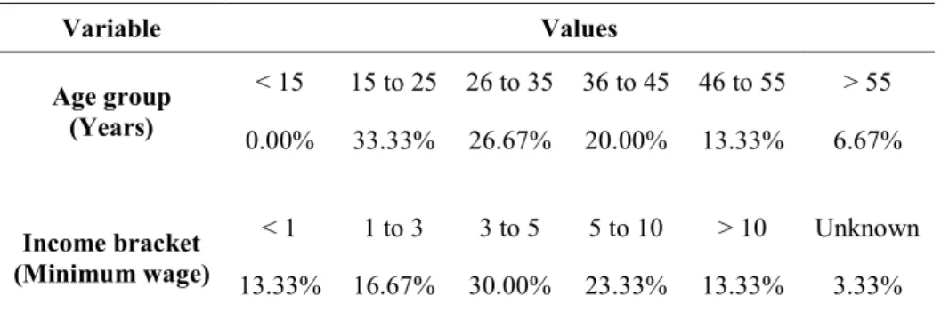
There were 30 people interviewed in the region of the Aterro do Lago Igapó II during time of the field research. Based on observations made from Tuesday to Thursday during a typical week, the hourly population of the research location is approximately 50 people. Thus, the sample size of interviewees represents 60% of the hourly population of individuals that normally frequent the embankment in the city of Londrina. The interviews were done in a single day during the afternoon. Table 1 has the data on the age group and income bracket of interviewees. It can be observed that the largest group of interviewees belongs to the age range of 15 to 25 years old. This reinforces the function of the embankment as a place to practice sport and leisure. On the other hand, since the research was done during work hours during a weekday, it could be possible that the presence of people in older age groups is reduced.
Table 1: Information about the age range and income of those interviewed Variable Values Age group (Years) < 15 15 to 25 26 to 35 36 to 45 46 to 55 > 55 0.00% 33.33% 26.67% 20.00% 13.33% 6.67% Income bracket (Minimum wage) < 1 1 to 3 3 to 5 5 to 10 > 10 Unknown 13.33% 16.67% 30.00% 23.33% 13.33% 3.33%
4.3. Perception of those interviewed in relation to the conceptual project
One of the main problems caused by inundations that occur in the area of the Aterro do Lago Igapó II are the interruption of vehicle traffic in the surrounding road system and the flooding of property located on the edges of the embankment. Thus, most of the interviewees indicated that economic motivations make them favorable to executing the project. It can be observed in Figure 3 that 76.67% of the interviewees indicated economic issues and other motives. The item for other motives refers to the fact that the interviewees reside in the region around the Lago and have their accessibility, mobility, and property affected by the flooding. These problems can cause financial damages of various forms, such as: loss of productivity at work; property damage by inundations and damage to durable and semi-durable goods.
8
Figure 3: Motivation for why those interviewed were in favor of implementing the project to increase the volume of the catchment basin of the Lago Igapó.
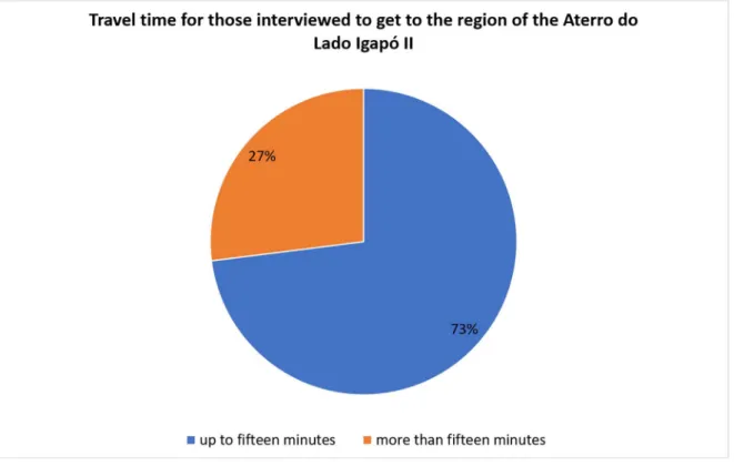
To support the fact that the interviewees resided in the region of the Aterro do Lago Igapó II, one can see in Figure 4 that the majority of them declared that they spend less than 15 minutes traveling on foot from their origin to the region of the embankment.
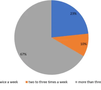
9 Despite accepting the proposal to increase the volume of the catchment basin of the Aterro do Lago Igapó II and of the potential benefits resulting from this project, the interviewees showed they were worried about the time duration of the work. Even though there was no stipulated span of time to execute the work of increasing the volume of the catchment basin. The interviewees justified this worry with the fact that the work would interrupt their recreational activities in the area of the embankment and the frequency of use of the location by the interviewees. In Figure 5, one can see that 67% of the interviewees use the embankment more than three times a week.
Figure 5: Frequency of use of the Aterro do Lago Igapó II by those interviewed.
On the other hand, some argument and proposals were also presented by the interviewers to the people responding to the questionnaires to support the importance and benefits of the work, such as: i) direct and indirect benefits in the reduction of various damages caused by inundations of property, to economic activities around the location and to transport and mobility systems; ii) possibility of community participation in decisions about the project according to the idea of a conceptual project presented by Ricieri et al. (2017) and Participate Melbourne (2017), since they would be supporting the proposal by financial and volunteer citizen methods; iii) realize the work in stages; and iv) provide nearby alternative locations to the embankment to maintain the recreational and leisure activities.
It is worth it to highlight the opinion of the interviewees about the interruption of the embankment by the proposed work. One interviewee does a social volunteering project in the sporting grounds on the embankment. He showed that he is very worried about this social activity being stopped because the developed social project serves diverse children and young people. Thus, the research and the use of the conceptual project allowed these people to express and demonstrate their expectations and perceptions in respect to this public space. Beyond this, allowing public managers to preview problems and present possible solutions to continue the social project and the proposal to make the region of the Aterro do Lago Igapó II resilient. The citizen that participates in the social project was in favor of the conceptual project presented by the researchers because he understands this would improve the region around the embankment.
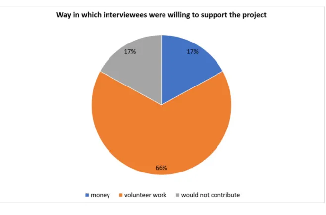
10 One of the main difficulties to solve problems in urban areas at present is the lack of financial resources to execute the work. The interviewees were asked if they would be willing to financially support the proposal to increase the volume of the catchment basin of the Aterro do Lago Igapó II.
According to Figure 6, the majority of interviewers would support the project in the form of volunteer work, in other words, 66% of interviewees. Beyond that, 17% were willing to contribute directly with money and 17% would not contribute.
Figure 6: Way in which interviewees were willing to support the project.
Due to the fact that a majority of the interviewees indicated they would contribute with volunteer work and since the work would involve technical civil engineering services, the interviewees were asked how the volunteer work could be done. Thus, they presented some ways to convert volunteer work into financial resources: educational campaigns and events in the very area of the lake embankment.
These campaigns would involve awareness for the population that uses the region of the Lago Igapó II through educational endeavors. These educational actions could be realized through traditional media (newspapers, radios, and television) and social media (Facebook, Twitter, Whatsapp). The financing of actions in the traditional media would be through the support of the companies doing the project. The events in the area of Aterro do Lago Igapó II already happen and are highly praised by the population of the city. Various events could be organized and operated to raise funds through symbolic and voluntary payment to shows, fairs, cultural and sport activities that would involve local and regional attractions.
Between the motivations cited by the interviewees to not contribute were: high tax costs in general; not agreeing with the policies of the current municipal government; not agreeing with current national and state policies; and there are lots of financial resources diverted by corruption. Between the motives cited by those that supported the project financially and in the form of volunteering are: the importance of not interrupting the road system for socioeconomic activities in the city; preserving the environment; improving the city and/or the Aterro do Lago Igapó II from the collective point of view, since people would be united to reach a common goal.
11 5. FINAL CONSIDERATIONS
Through this study, it was possible to prove that the inundations occurring the past few years have caused economic damages, reduction in accessibility and mobility for the population that lives, works, and frequents the region of Aterro do Lago Igapó II in Londrino. According to the responses to the questionnaire, all the interviewees said they were in favor of completing the project to increase the size of the catchment basin of the lake embankment. Beyond that, it was possible to indicate that the majority of the interviewees were favorable to the project for socioeconomic reasons, essentially, they work or live around the area. This can be proven by the fact the majority of participants in the study reside near the lake embankment, since most indicated their travel time is no more than 15 minutes on foot.
Even though all the interviewees were in favor of the project, there are worries about the interruption of the location’s utilization. The main argument for the interviewees is in the extended amount of time the work could take, despite not having stipulated during the interviews a span of time in which the work would be executed. According to the interviewees there would be damages, primarily, to recreational activities and sports that are done daily at the lake embankment. This worry was justified by the history of delays in other revitalization and adequacy projects of some equipment that make up the embankment, such as: sand courts; wood bridges; benches; recreational tables, etc.
In relation to the financial support for the project that could make the region resilient, the majority of interviewees agree with contributing through volunteer work. There is a group that would contribute with money and another group of the same percentage that would not contribute. The most often recurring justification to not contribute to the project is related to the perception that the city mayor’s office already accrues too much in taxes and thus should fully finance the work. From the interviewees willing to contribute with volunteering, the following observation can be made: since it regards a civil engineering job, mainly moving a significant volume of soil, the volunteer work would have to be comprised of educational campaigns and fundraising events. The campaigns would be done throughout the city through traditional and social media and the events could take place on the lake embankment itself. Both the educational campaign and the events would serve to explain and demonstrate the final goal of making the area resilient, as well as fostering this kind of action in other places in the city. Those who use the location and citizens will also be able to note the importance of making resilient the property and road systems around the lake embankment. Thus, financial support for the project, primarily in the form of volunteer work, could guarantee the frequency of population to the lake embankment to realize their economic and/or recreational activities.
Acknowledgements
The authors thank those interviewed that contributed through their perception and time to the realization of the field research and Londrina State University (Universidade Estadual de Londrina) for the support in the form of the availability of its infrastructure for the completion of this study.
6. BIBLIOGRAPHICAL REFERENCES
Coura, C. L. e P. D. Dos Santos (2016) Propostas de Soluções para os Problemas de Enchente na Rua Delfim Moreira, Localizado no Bairro Medicina em Itajaú-MG. Revista Univap, v. 22, n. 40, p. 191.
Cradock, A. L.; J. L. Barrett; J. F. Chriqui; K. R. Everson; K. V. Goins; J. Gustat; K. M. Heinrich; C. K. Perry; M. Scanze; T. L. Schmid; R. G. Tabak; M. R. U. Meyer e C. Valko (2018) Driven to support: individual-and county-level factors associated with public support for active transportation policies.
12 American journal of health promotion. v. 32, n.3, p. 657-666.
De Bortolo, C. A. (2010) A produção de um Espaço Público e os Agentes Produtores da Cidade: o Caso do Lago Igapó em Londrina-PR. Geop UERJ, v. 2, n. 21, p. 287-311.
De Bortolo, C. A. e T. M. Fresca (2011) Produção e Apropriação de Espaço Livre Público: Lago Igapó em Londrina-PR. Revista Geografia da América Central, v.2, p. 1-15.
De Souza Bragança, L.; L. P. Da Fonseca e M. A. G. M. Da Hora (2016) Integração entre Medidas de Controle de Enchentes e o Aproveitamento Social Urbano do Rio Jacaré - Município do Rio de Janeiro. Labor e Engenho, v. 10, n. 4, p. 357-368.
Decina, T. G. T. e J. L. B. Brandão (2016) Análise de Desempenho de Medidas Estruturais e Não Estruturais de Controle de Inundações em uma Bacia Urbana. Engenharia Sanitária e Ambiental. v. 21, n. 1, p. 207-217.
IBGE CIDADES (2017). Dados sociodemográficos do município de Londrina-Paraná. https://cidades.ibge.gov.br/brasil/pr/londrina/panorama. Acesso em 01 de junho de 2018.
Gomes, V. H. (2018) Projetos conceituais como ferramenta para integrar a opinião dos usuários ao planejamento de transportes. Dissertação de Mestrado. UEL - Universidade Estadual de Londrina. Londrina.
Jacobs, J. (2011) Morte e vida de grandes cidades. 3ª edição. São Paulo: Editora WMF Martins Fontes.
Larocca, A. G.; C. Cardoso e B. L. D. De Angelis (2017) O Impacto da Ocupação de Fundo de Vales em Áreas Urbanas - Estudo de Caso Lago Igapó Londrina-PR. Revista Nacional de Gerenciamento de Cidades, v.5, n. 30.
Leobons, C.M.; V.B.G. Campos e R. A. M. Bandeira (2017) O Conceito de Resiliência aplicado a Sistemas de Transportes. Anais do XXI Congresso de Pesquisa e Ensino em Transportes, ANPET, Recife, v.1, p. 1-12.
Long, M. W.; S. L. Gortmaker; A. I. Patel; S. J. Onufrak; C. L Wilking e A. L. Cradock (2018) Public Percepiton of Quality and Support for Required Access to Drinking Water in Schools and Parks. American Journal of Health Promotion, v. 32, n.1 p. 72-74.
Nascimento, N. O.; M. B. Baptista e E. V. Sperling (1999) Problemas de Inserção Ambiental de Bacias de Detenção em Meio Urbano. Congresso Brasileiro de Engenharia Sanitária e Ambiental, 20 Feira Internacional de Tecnologias de Saneamento Ambiental, 3. ABES, p. 1-9.
Participate Melbourne: Streetscape Improvements Program (2017). Disponível em: <http://participate.melbourne.vic.gov.au/streetscapes>. Acesso em 2 de junho de 2018.
Ricieri, M. G.; C. M. Fernandes; V. H. Gomes; H. B. FONTENELE e C. A. Prado da Silva Junior (2017) Análise de duas alternativas de transporte por meio do planejamento participativo. Anais do XXXI Congresso Nacional de Pesquisa em Transporte da ANPET, Recife, v. 1. p. 1-10.