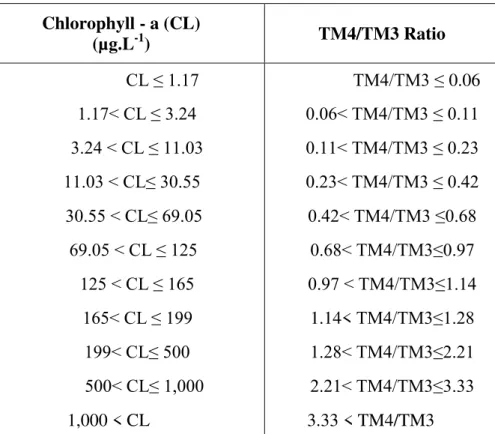
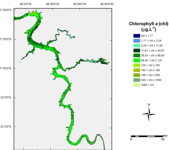
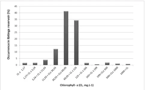
Proposal for a remote sensing trophic state index based upon Thematic MapperLandsat images
Texto
Imagem

Documentos relacionados
The probability of attending school four our group of interest in this region increased by 6.5 percentage points after the expansion of the Bolsa Família program in 2007 and
Ao Dr Oliver Duenisch pelos contatos feitos e orientação de língua estrangeira Ao Dr Agenor Maccari pela ajuda na viabilização da área do experimento de campo Ao Dr Rudi Arno
Uma das explicações para a não utilização dos recursos do Fundo foi devido ao processo de reconstrução dos países europeus, e devido ao grande fluxo de capitais no
Neste trabalho o objetivo central foi a ampliação e adequação do procedimento e programa computacional baseado no programa comercial MSC.PATRAN, para a geração automática de modelos
Ousasse apontar algumas hipóteses para a solução desse problema público a partir do exposto dos autores usados como base para fundamentação teórica, da análise dos dados
FIGURA 5 - FLUTUAÇÃO POPULACIONAL DE Hypothenemus eruditus, Sampsonius dampfi e Xyleborus affinis (SCOLYTINAE, CURCULIONIDAE) COLETADOS COM ARMADILHAS ETANÓLICAS (25%)
The objective of this work was to evaluate the relationship between different remote sensing data, derived from satellite images, and interrill soil losses obtained in the field
Based on the interpretation of satellite images, the creation of thematic maps, and quantification in the GIS environment, it was evident that there is an intensification of the
