TOURISM PLANNING INFORMATIZATION
38 TH CONGRESS OF THE EUROPEAN REGIONAL SCIENCE ASSOCIATION
CÉLIA RAMOS ESGHT – UALG Faro – PORTUGAL
Cmramos@ualg.pt
Fax n.º: +351.89 80 0100
MÁRIO RUI GOMES IST – UTL
Lisbon - PORTUGAL
Mrg@camoes.rnl.ist.utl.pt
Fax n.º: +351 1 3100289
Abstract
The Tourism activity, due to its own characteristics, causes high environmental impact and its development should be influenced by the environmental characteristics of each region.
The Information Systems, mainly those which represent the geographical information, will permit the development of a design, allowing the Decision-Maker the consult, the management and the presentation of decision schemes based on the defined measures of the Tourism Planning of a region. As the information associated with this design should be real and update, the Internet should be used as a means of access to the information of the region.
The design presents the schemes associated to each decision, offering competitive advantages to the Decision-Makers involved in the decision process, since it is possible to evaluate, foresee and control the future environmental impacts of Tourism.
Keywords
Information Systems; Database Management Systems; Tourism Planning; Decision Support Systems.
1. INTRODUCTION
The Algarve region has always been sought after by tourists in Portugal. This preference is motivated by the sun, beach, and good weather which we can appreciate all year round in the Algarve. Meanwhile, in the region tourism development has not taken in consideration the developing plans, which is noted by the actual environmental imbalances and the imbalances which will appear in the near future.
But, the Algarve region developing plans which considered environmental protection and population imbalance, Regional Tourism Plan (Plano Regional do Turismo - PRT) and the Territorial Planning Regional Plan (Plano Regional do Ordenamento do Território - PROT), were only developed in the early 90s. These Plans were the first but Tourism was an emerging activity lacking in the technology needed to present, manage and analyse large quantities of information, and so these Plans did not resolve some of the problems in the Algarve region at the level of the environmental impact caused by the developing activity:
How can an evaluation and prediction of the environmental effects caused by developing tourism be made?
How can control and readjustment in one place, as a means to decreasing and avoiding the environmental impacts caused by tourism’s developing activity?
Natives of the region have been affected by Tourism’s rapid growth, problems can be seen related to changes in the quality and style of life, the visitors received in the region (i.e. tourists) and increased cultural, social and ecological degradation.
The success of these Plans was restricted by the absence of: the technological means which would allow the detection and prediction of environmental impact, the absence of technological access to large quantities of available information (different places with different characteristics) and sharing in a decision support environment.
The decision support system would facilitate, prediction, evaluation and readjustment of environmental impacts caused by tourism, allowing the Decision-Maker to make a better (clearer) decision.
Technology should be designed to support tourism planning, characterised by the storing of large quantities of information, querying and management; and showing a decision support environment where it would be possible to predict, evaluate and readjust the environmental impacts caused by the development of tourism.
2. TOURISM PLANNING SUPPORT SYSTEM ( SAPOT )
The design of Tourism Planning Support System (Sistema de Apoio ao Planeamento e Ordenamento Turístico - SAPOT) considered the Information Systems (IS), Tourism Planning (TP) and Decision Support Systems (DSS) as it base for its development. Information Systems, because they structure the different information categories associated to the real system which characterises the Tourism Planning. The Tourism Planning because it is the biggest restriction tourist activity development. The Decision Support Systems to define and present decision schemes, which allow the Decision-Maker to take advantage in the decision process as a way to increase the strategical potentialities in the regional development, process.
2.1. Information Systems
The Information Systems structure the different information categories associated to the real system and use the Database Management Systems (DBMS) as a technology to manipulate the information associated to the system. The DBMSs permit the development of a design which permits querying, presentation and storage of large quantities of management information in a Database characterised by an efficient and consistent environment to access the information, guaranteeing information security in storage, guaranteeing the minimum of system failures and guaranteeing secure ways to access the Database. The information stored will be characterised by the theories from IS, as a way to guarantee a system composed of redundant information (absence of duplicated data), independent information (the physical and logical storing was separated) and persistent information (data is defined with a unique meaning in the system) (Carapuça, 1993).
To represent a real system in an IS the main problem is in the identifying information categories, to solve this problem we will use the theories of data modelling.
Data modelling should be defined as a conceptual collection of tools used to describe the data, the relationships between the data, the semantic and limitations between the same. The chosen model was the Relation Model, due to its characteristics: simple and flexible structure, because this model considered that in a real system the data and their relationships are represented by a double entry table collection. Each column represents one kind of information and each row represents an element, the relationship between the different tables are defined by common fields in the relative tables.
One DBMS is the technology used to conceptualise the design associated to an IS, the conception of the computational model is realised after the definition of the conceptual model associated to the IS. The conceptual model is defined by elements which characterise the systems in terms of data, relationships and the design behaviour proposed, that is, by Entity-Relationship Diagram (ERD), Data Dictionary (DD) and the State Transition Diagram (STD).
2.1.1. Entity-Relationship Diagram
The definition of an Entity-Relationship Diagram associated to a real system is based on a real world perception, in which exists a collection of elementary objects, designated by “entities” and “relationships” between them. This diagram is defined by specific symbols: the object collection “entities” is represented by a rectangle, a “relationship” by a losange, the object characteristics “attributes” by an ellipse and affection between the objects by lines (YOURDON, 1989).
The information associated to each object collection should be stored with the minimum redundancy, independence and persistence, and should be submitted to the application of the normalisation rules, for example: Normal Forms, which guarantee a non dependent, non persistent and non duplicated information.
After the definition of the entities and the relationships, which characterise the real system, it is possible to define all the elements, which characterise the system by the Data Dictionary.
2.1.2. Data Dictionary
A Data Dictionary is a report of all data which are essential to the system, defined with rigor and precision so the User/Programmer can understand all the stored data, all the input data and the output data and arithmetic operations to do with the data.
The elements that compound the Data Dictionary have as the main objective to decrease the complexity of system behaviour and presents the complexity in terms of simple data elements, defined by specific symbols, types and values (Yourdon, 1989). They define the data characteristics by the flux description and data storing, description of each data, description of the relationships, specification of the relevant values and the units of the elementary attributes.
The definition of a Data Dictionary is a slow and boring task but allows the Programmer to build an efficient and precise DBMS.
The Data Dictionary and the Entity-Relationship Diagram only define the data and relationships characteristics of the design to be developed. To show the way in which the design will access/modify the data it necessary to present it’s behaviour by the State Transition Diagram.
2.1.3. State Transition Diagram
The State Transition Diagram presents the behaviour of the design. The dynamic of the DBMS is described by the STD which uses a rectangle to identify a behaviour state (form) and an arrow for possible behaviour changes (Yourdon, 1989). The different behaviours associated to the system by a collection of forms are designated by the Human-Machine Interface (HMI).
In the conceptual model definition associated to an IS, it is important that the technology used to manage large quantities of information – DBMS, but also appropriate technology to find and update data. In the near future, one of the technological tools which could guarantee success to an IS is the Internet because it is a powerful tool to rapidly access the different categories of information.
Usually, the terms “IS” and “DBMS” are used to refer to general information, but if a specification of information category exists, the above terms will change to identify the kind of information, for example, if the information associated to the system is geographical then designation will be “Geographical Information Systems (GIS)” and “Spatial Database Management System (SDBMS)”.
A GIS is characterised by storing, management and spatial information manipulation (geographical and alphanumerical); including operations which support spatial analysis. The relevance of this system (Goodchild, 1990) is indicated by three factors: integration of spatial information with other information categories, administrative information by geographical locations, and relating activities by their geographical position.
The GIS permits analysing of the geographical problems mainly those related to the environment and permits increasing of the environmental manipulation needed for Tourism Planning.
2.2. Tourism Planning
The development of an activity in a specific place should be directed and controlled to work within with the ecological, social, cultural and economical constraints.
Tourism is an activity, which consumes geographical space where it is currently developing: infrastructures building for tourist uses, using local resources, integration of the native population or environmental degradation.
The touristic development of a place is represented in time by phases with proper characteristics, designated by Tourism Life Cycle (Jansen-Verbeke, 1994). The Tourism Life Cycle is stated by a strong growth during the initial phase – new site exploration, followed by high demand, which causes saturation and the decreasing tourism demand. If a tourist resort reaches maturity its demand is at its highest value after this point degradation in the quality of the different resources that characterise the environment of the tourism place start to appear. Then, the necessity of tourism planning is a major concern, to control development in a way to guarantee growth and revenues by increasing demand without decreasing the quality offered. Planning is considerated to be a way to provide environmental protection, to control the level of the natural
resources, to keep and if it is possible to improve the quality of life in the region and should protect the tourism resources, decrease the current environmental impacts and those which could appear in the near future.
The objective of Planning is to direct the growth of an activity to guarantee specific goals. The Planning should be developed after the information changes and the co-ordination of interdependent activities to collect and secure treatment of the information about the future.
An interdependent activity is considerated as a system which represents something in the real world, has proper characteristics and it is ruled by specific norms. If we consider the tourism activity as a system ruled by the norms defined in the Regional Tourism Plan (Plano Regional do Turismo - PRT), Territorial Planning Regional Plan (Plano Regional do Ordenamento do Território - PROT), and World Tourism Organisation; those should interact in the tourism management related to the space, time and decision domains; then it is possible to build simulation models to control development activity using the IS.
Tourism development activity in the last decades has brought with it uncontrolled occupation in some sites (tourism infrastructures and tourism equipment) and without respect to the limits of the development areas; this caused environmental impacts at a social, cultural, economical and ecological level.
Uncontrolled space occupation implicates the necessity to find decision support which should include strategic actions as a way for each region to reacquire their balance – Tourism Planning.
Tourism Planning is based on specific objectives, is executed by a collection of strategic actions which permit structural and quality changes as a new spatial organisation to the activity allowing control, evaluation and to readjustment, making possible the realisation of a decision support system which should protect the natural, historical and cultural resources.
The Planning implementation means essential structural and quality changes as well a new spatial organisation, which creates a decision support environment and facilitates the development and building of simulation models to control, evaluate and readjust the
development of the activity conjugated with an adequate computational tool to evaluate the real capacity and the factors which lead to saturation.
To evaluate the real necessities and the factors which lead to saturation it is necessary to evaluate the environmental impacts that tourism development activity causes in a specific region. This evaluation is defined by quality and quantity indicators. Nowadays, some studies about environmental impacts are appearing but as the tourism activity is recent there was neither standard indicators nor standard scales to classify the indicators. Meanwhile, the saturation point can be measured by the carrying capacity. Each site is characterised by a different carrying capacity, which means knowing the total carrying capacity of a region it is necessary to sum all the carrying capacities from each tourist site (Mendes, 1994).
Σ
K
≥P
Where Σ k is the total carrying capacity from the different tourist sites and P is the tourist flux.
If the tourist flux overflow the total carrying capacity it is possible to predict that in the near future that will appear tourist resorts with high environment degradation as well as tourism resource degradation.
The absence of computational means could be a main factor to limit the region in competition with another’s in terms of their development. The institutional norms (PRTs, PROTs,...) together with a design that enables the decision process, and allows quick and efficient manipulation of the great quantity of information, should be one of the best ways to arrive at a decision for a localised problem and to find a solution to eliminate the region asymmetries.
2.3. Conceptual System of Tourism Planning
In the last decades, developing tourism caused negatives environmental impacts, the necessity to control and predict in the future is essential for the development of a country, region and a site. This development should consider the institutional norms and politics defined by the development which has the objective to protect the environment,
to decrease the degradation and to control the quality of the environmental resources, but also should consider computational tools as a way which enables the decision support environment, the interaction between the different economic sectors, and the manipulation of a large quantity of information. If the touristic activity is an interdependent real system and situated in a geographical space then it is possible structure it in an information system.
The geographical space considered will be the Algarve, the offer of Sun, beach, Golf courses, etc. make the southern region one of the major tourist attractions of Portugal. Meanwhile, the Algarve is characterised by different places with specific environments, which makes the study of environmental impacts in the Algarve region more difficult. The necessity to reduce the study space is a major concern that implicates a selection of a place between the same region. Loulé was selected from amongst places which make up the region, because it is one of the major tourist attractions in the Algarve region, is situated within Ria Formosa Natural Park, and it is made up of three territorial units which characterise the region: Barrocal, Mountain and Coast.
The development of the tourism system is conditioned by the World Tourism Organisation norms (WTO), PRT to Algarve (PRTA), PROT to Algarve (PROTAL), among others.
Once the real system has been introduced steps will be indicated to start the entity identification and ends with the design model (methodology):
Identifying the information categories:
The Information System associated to the conceptual design is composed of different information categories associated with the real system.
Physical characteristics of the place, tourist resources;
World Tourism Organisation norms;
PRTA objectives and
Decision support data. Conceptual System Design:
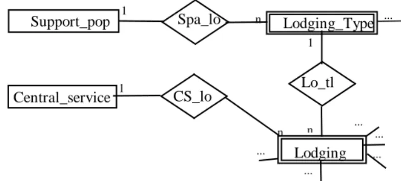
Entity-Relationship Diagram, which describe the system according to a collection of basic elements designated by “entities” and “relationships” between them (vid. Figure 1),
Data Dictionary, report of all data, which is essential to the system: defined with precision and rigor to explain all the stored data, all inputs and outputs to the system, arithmetic operations to do with the data (vid. Figure 2) and
... ... ... ...
n
Support_pop 1 Spa_lo Lodging_Type 1 ... CS_lo Lodging n 1 n ... Central_service Lo_tl
Figure 1 – Portion of Entity-Relationship Diagram
Lodging_type = {lodging_type}
Lodging_type = *Shows the information associated to to WTO norms for each lodging type* @Id_lt + Desc_lt + (Avg_r) + Dens_lt + 1{water} + 1{support_pop}
Id_lt = *Identify the lodging type; type: INTEGER*
1{digit}2
Desc_lt = *Description of the Lodging type; type: VARCHAR2(n)*
1{character}40
Avg_r = *Rooms average; type: INTEGER* {digit}
Dens_lt = *Area for bed (m2/bed); type: FLOAT; units: m2/bed*
1{digit}10
State Transition Diagram, define the behaviour of the design associated to the Database Management System and presents all the actions which characterise the computation design (vid. Figure 3).
Finally, we should select the ideal way to find information:
An Information System should be characterised by update information, and should use a quick and efficient way to get the information –
Internet.
After the presentation of information conceptual design, associated information systems will be implemented (computational design).
2.4. Information System implementation of Tourism Planning
The conception of the computational design include the construction of the components that defines the conceptual model associated to the IS which structures the information associated to the real system.
The computational components should developed in a work environment adequate to the objective design, accordingly with the large quantity of information to manipulate considering the place where the system will be applied and data that should be calculated/presented.
The DBMS selected was the Oracle Power Objects (developed by Oracle
Corporation). Because it has a work environment characterised by a object oriented development, can access local or remote databases, works with a known programming language (Structured Query Language (SQL) and Oracle Basic), Client-Server Design, manipulates large quantity of information and for a quick development of programs in a graphical environment.
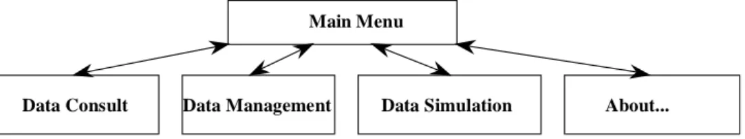
Data Consult Data Management Data Simulation About...
Main Menu
The characteristics described above defines the Oracle Power Objects as an ideal work environment to develop a design where the querying, storing and management of large quantities of information will be done in a simple, efficient and quick way as the definition of a Human-Machine Interface (HMI), intuitive and easy use.
The HMI is an important component in the development of design associated to a DBMS because the User interacts with the design by this component. The HMI is composed of behaviour redirect forms and data manipulation/presentation forms.
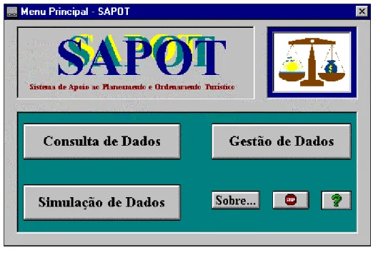
The HMI composed by the behaviour redirect forms simplifies the selection of a specific behaviour to the program that is described by the State Transition Diagram. An example of this kind of form is that represents the “Main Menu” (vid. Figure 4).
The HMI composed of the data manipulation/presentation forms hides the physical storage complexity and calculation complexity, permitting us to keep some data confidential. These kinds of forms can be divided in two sub-types: forms that only permit consultation and forms that do calculation with the database data.
In this design, the data manipulation forms are the most relevant because they permit to Decision-Maker to define the characteristics of thedecision schemes and the PRT operational actions associated to each scheme and to calculate the decision schemes data.
The decision schemes are build as the result of the execution of the next steps:
(1st) To consult the set of actions associated to the PRTA Objectives (to consult the actions or to remember the actions to apply).
(2nd) To define a new interaction between tourism resources and the PRTA Objectives (after the action selection the applicant should record the interaction number which will be applied).
(3rd) To insert new data to the objectives to be applied in a tourism site (after the action selection and interaction record the applicant should insert the fiction data to build new decision schemes).
(4th) To delete the data associated to unnecessary decision schemes (decision number) (to delete the data that is unnecessary).
(5th) To calculate new data for decision schemes, due to new interactions (calculate the data which will be used in the construction of the decision schemes).
(6th) To consult the computed data in the decision schemes (show the
decision schemes build in the previous).
(7th) End of the simulation (end of the construction of decision schemes). These steps are shown to the User in a form designated “New Data Simulation”. After the execution of a command set in the 5th step, the decision schemes defined by the Decision-Maker are built.
The command set that computes the data to build the decision schemes is defined by the next algorithm developed in SQL and Oracle Basic programming language (vid. Figure 5).
After the execution commands associated to the algorithm, the table with the decision support data has one record for each decision scheme defined by the Decision-Maker where each scheme was submitted to the different actions indicated by the PRT operational objectives. Meanwhile, the decision scheme with the number zero represents the real system (vid. Figure 6).
By observing different decision Schemes it is possible to assert that the Decision-Maker can use an design with the presented characteristics and he will have an advantage in the decision process so he will have an idea of the environmental impacts caused by the application of a specific PRT action.
‘Delete the data in the decision support table EXEC SQL DELETE FROM sist_apoio_dec
' Variable declaration
DIM vregisto AS Long 'Decision number in interaction table DIM vnum AS Integer 'interaction number for the current decision DIM vcamas AS Long 'number of beds
...
' Set the initial values for variables vregisto = 0
vcamas = 0 ...
'Count the decision number considered by interactions
EXEC SQL SELECT MAX(id_d) INTO :vregisto FROM interaccao 'For each decision we compute new data
FOR vi = 0 TO vregisto
'Verify if exists an interaction with the number in vi variable vnum = 0
EXEC SQL SELECT COUNT(id_d) INTO :vnum FROM Interaccao WHERE id_d = :vi
‘If the interaction number is different from zero for each decision then compute data associated to the decision schemes IF vnum <> 0 THEN
'Starts the computation 'Computes the number of beds
'Select all data which have interaction number equal to zero or to the current decision number EXEC SQL SELECT SUM(camas) INTO :vcamas FROM alojamento &
WHERE (dec_al = :vi OR dec_al = 0) 'Computes the value of ....
...
'Insert new data in decision support table EXEC SQL INSERT INTO sist_apoio_dec &
(ID_D,...,_CAMAS,...) VALUES (:vi,...,:vcamas,...) END IF
‘Increment the decision number NEXT vi
‘Confirm the new decision data stored in the decision support table EXEC SQL COMMIT
3. CONCLUSION
The goal of this work was to show a computational design characterised by a great capacity to manipulate large quantities of information which allow the building of a decision support environment where the Decision-Maker has competitive advantages in the decision process, as a way to decrease the errors in the decision that they have to take and to reduce the dispensed time used in the decision process.
To reach the proposed objective we considered the Database Management Systems as a technology which permits the construction of a Decision support System, where the decisions that have to be taken are not shown but the Decision-Maker can consult the probable consequences by the application of a specific institutional measure (PRTA action).
Computer technology should be considered in the economic sector, mainly those related Figure 6 – Consult of the decision schemes
Geographical Information Systems (GIS) to have access to the spatial information where the sector is in development. More and more, the Decision-Makers and the Researchers use this technological way to search, consult and analyse schemes of thematic models to the place, region or sector development
Internet, to have access in real-time update information of the governmental rules, geographical space changes, statistical data, etc. Permit a bi-directional and interactive as a way to create a new kind of relationship between the “Local Decision-Maker” and the “Regional Decision-Maker”, and between the “Regional Decision-Maker” and the “National Decision-Maker”.
The combination of governmental rules limiting a sector development with a computer tool. This combination permits an active participation in the public administration management and in the service decentralisation because it is dependent on the management of information and only is possible if actual and innovate technology is used.
The interchange between different scientific areas is essential to the
development and execution of a computational tool that has the goal of reaching the objective of the proposed design. Is relevant the dialogue between the specialist of other scientific areas.
The Planning Tourism Support System (SAPOT) is just a starting point in the region developing support systems, but shows that design with the specified characteristics gives decision support information to the Decision-Maker which permits control and readjustment of environmental impacts caused by the touristic development activity by the analysing and prediction of the consequences provoked by the application of a specific governmental or political sector in spite of another.
Bibliography
ASSOREIRA, D. (1990). «Plano Regional de Ordenamento do Território do Algarve
CARAPUÇA, R. (1993). «Introdução aos Sistemas de Informação e Base de Dados
-Texto de Apoio». Lisboa. IST/UTL.
GOODCHILD, M.F. KEMP,K. (1990). «Introduction to GIS - NCGIA (National Center for
Geographic Information and Analysis)». Edited by: Michael F. Goodchild and
Karen K. Kemp.
GRANT, T. LEVINGER, J. ROBERTS, C. (1995). Oracle Power Objects User’s Guide
-versão 1.0. C.A., Oracle Corporation.
JANSEN-VERBEKE, M. (1994). «Tourism: Quo Vadis? From “Business as usual” to
Crisis management». Rotterdam, Erasmus University Rotterdam.
MARTINS, P. ASSOREIRA, D. CAVACO, H. (1994). Plano Regional de Turismo do
Algarve - PRTA. Faro, CCRA.
MENDES, J.L.M.F. (1994). Critérios e Indicadores das Zonas Turísticas Saturadas.
Lisboa, DGT (Direcção Geral do Turismo) - FCT/UNL.
OMT-WTO-BTO s.d., «Risks of Saturation or Tourism Carrying capacity overload in
holiday destinations». Madrid, Organisation Mondiale du Tourism - World
Tourism Organization - Organizacion Mundial del Turismo.
ROBERTS, C. (1995). Getting Started with Oracle Power Objects - versão 1.0. C.A., Oracle Corporation.
SILVA, J.A. (1994). Impacte do Turismo no Ambiente. Lisboa, DGT e FCT/UNL.
VITORINO, J. (1993). Estudo Económico do Concelho de Loulé. Loulé, Confederação dos Empresários do Algarve (CEAL).