i
Nicholas Azenui Asanga
Modelling Customary Land Tenure in relation to the
National Land Administration model (Case study of the
Northwest region of Cameroon)
ii
DECLARATION
I, Nicholas Azenui Asanga, a master student of the Geospatial Technology Erasmus Mundus
program, am aware of my responsibility of the penal law, declare and certify with my signature
that my thesis entitled
“Modelling Customary Land Tenure in relation to the National Land Administration
model (Case study of the Northwest region of Cameroon)”
is entirely the result of my own work I have faithfully and accurately cited all my sources, including
books, journals, handouts, and unpublished manuscripts, as well as any other media, such as the
Internet, letters or significant personal communication?
I understand that
- literal citing without using quotation marks and marking the references
- citing the contents of work without marking the references
- using the thoughts of somebody else whose work was published, as of our own thoughts are
counted as plagiarism.
I declare that I understood the concept of plagiarism and I acknowledge that my thesis will be
rejected in case of plagiarism.
iii
Modeling Customary Land Tenure in relation to the National Land
Administration model (Case study of the Northwest region of
Cameroon)
Dissertation supervised by:
Doctor Malumbo Chipofya,
Institute for Geoinformatics,
University of Munster, Germany
Co-supervised by
Professor Doctor Pedro Cabral,
NOVA IMS Lisbon, Portugal
Co-supervised by
Professor Doctor Michael Gould
Universitat Jaume I,
Castalleon de la Plana, Spain
iv
Acknowledgment
I would like to thank all the professors and other staff working on the Master of Science in Geospatial Technologies for making my stay an enriching and enjoyable one. Thanks to my three supervisors for their comments and support. A special note of thanks goes to Doctor Malumbo Chipofya for his enormous help and guidance during the period of my research. Thanks to my colleagues on the master program for their friendship and support, especially those in Munster who put up with unlimited questions and complaints over the past six months. Last but most important, I acknowledge the help of my family back home.
v
Abstract
Land administration systems all over the world are always preoccupied with the registration of land as it is one of the only ways to have legal ownership of property and do not ever address customary right to land on a full scale. The conventional land tenure systems in Cameroon have is not fully integrated and written in the official land administration system of the country. Cameroon comprises about 250 ethics different having different customary land tenure systems most of which have similar concepts and features. This thesis seeks to provide an overview of these standard systems and comparing it with the official land tenure system to understand where the systems counteract. The Northwest region of the country was chosen as a case study as it has a customary system that is like other ethnic groups in the country. The idea was to develop domain models for the two systems and propose ways by which the government can assimilate the customary system into the legal system.
This thesis describes the development as an ontology, and it represents the comparison between the two systems. The ontology approach was chosen as it efficiently models concepts related to land tenure that can be easily integrated into other systems for assimilations. The building of the customary land tenure system models based on ideas gotten from the concept of the Social Tenure Domain Model (STDM) as it gives the standards for modeling concepts based on epistemology and reality. The model was validated demonstrations of some instances related to data gotten from content analysis and was found to be valid.
Keywords: Land Administration Domain Model (LADM), Cadaster, Social Tenure Domain Model, Customary Land Tenure, Ontology
vi
Contents
DECLARATION ... ii Acknowledgment ... iv Abstract ... v 1. INTRODUCTION ... 11.1. Background of research case study ... 3
1.1.1. The concept of land in Cameroon ... 3
1.1.2. History of land tenure in Cameroon ... 4
1.2. Research problem and justification ... 6
1.2.1. Research problem ... 6 1.2.2. Research justification ... 7 1.3. Research objectives ... 9 1.3.1. Research question ... 9 1.4. Thesis structure ... 9 2. Literature review ... 10 2.1. Overview ... 10
2.2. Customary land tenure ... 10
Customary land tenure system and transaction processes (Case study of the NSO tribe) ... 10
The case of land tenure conflicts. ... 11
2.3. Representation of land administration ... 12
2.3.1. Ontology. ... 12
2.4. Land administration ... 13
2.4.1. The land administration domain model ... 14
2.4.2. Social tenure domain model (STDM) ... 15
3. Methodology ... 17
3.1. Data acquisition ... 17
Content analysis or Literature review ... 18
Interview and questionnaire ... 18
3.2. Method for developing the ontology ... 19
3.2.1. Collating information ... 19
3.2.2. Initial structuring ... 20
3.2.3. Formalization ... 20
vii
3.4. The ontology ... 21
3.4.1. The structure of the Northwest region (Grass field) Ontology ... 21
3.4.2. Activity class ... 23
3.4.3. EnvironmentalCharacteristic class ... 24
3.4.4. EstateComponent class ... 31
3.4.5. SocialComponent class ... 32
3.4.6. Summary ... 33
3.5. Official land administration ontology. ... 33
3.5.1. Overview ... 33
3.5.2. RRR Class. ... 34
3.5.3. Party class ... 38
3.5.4. BAUnit class ... 40
3.5.5. spatial unit class ... 41
3.5.6. Summary ... 43
4. Results and discussions ... 44
4.1. The Northwest region ontology and its related stories ... 44
4.1.1. Land transaction ... 44
4.1.2. Land conflicts ... 45
4.2. The main findings related to LADM and customary land tenure in Cameroon ... 47
5. Validation of the ontology ... 49
5.1. Customary land tenure system and transaction processes ... 49
5.2. The case of land conflicts... 50
5.3. Summary ... 50
6. Limitations and challenges... 51
6.1. Limitations ... 51 6.2. Challenges ... 51 6.3. Future work ... 51 7. Conclusion ... 52 References ... 53 Appendix ... 56 Questionnaires ... 56 Full ontology ... 56
1
1. INTRODUCTION
In geography, land often referred to as dry land is a solid surface of the earth that is not permanently covered by water. Most anthropogenic activities throughout history have occurred inland areas that support agriculture, habitat and various natural resources.
West Africa is well known as an area of abundant land with little population pressure, yet this notion is increasingly being transformed. Historically, the land was hardly a scar force factor of production and agricultural productivity was limited due to cultivation technologies and human labor dependency (Hart, 1982).
Land use was commonly the natural rights of individuals depending on their membership in the community. However, since the colonial period, rights to land, land access and control has taken new and ever dynamic forms which have affected the standard customary land tenure systems. More so population pressure, cash crop production, inelasticity in the supply of land, the sale of land and individual land titles policies have significantly reflected different socioeconomic statuses and the symbolic value of the property of these communities.
The increase in land use and transactions has led to the need for the tracking of the continuity and change in land use and sales thus the need for land policy. Most of this land policy is put in place to track and record land and property transaction, registration and cadaster and this has been going on for thousands of years
Land registration generally describes the system by which matters concerning ownership, possession or other rights in land can be recorded usually with government agencies and other area and environmental management bodies. It mainly provides evidence of title, facilitates and legalizes property transaction. The cadaster is a method of land registration designed to ensure the right of individuals and state to properties. Cadastre and land registration are both types of land recording and complement each other.
Due to the vast resources land has to offer to range from agriculture, habitat, minerals, water, and forest, there have been critical examinations of who to gain access to the area and how they use the property and carry out transactions with it eventually leading to the adoption of several land policies both formal and informal.
During the pre-colonial era in Africa, the primary land use was agriculture, habitat, and forestry (gathering and hunting). The principal means of getting access to land was through lineage (Joireman, 2007). Usually, the property was shared among those who traced their lineage through common female ancestors in some countries like Ghana, and male ancestors in some countries like
2
Cameroon, Nigeria, Congo, Chad (Selase & Worlanyo, 2015). There was hardly ever any conflict regarding land ownership as the traditional belief was so strict to that punishment will be bestowed to anyone who deprives another of his rightful possession of land by the ancestors. It was also possible as the chiefs of kings were the supreme ruler of their chiefdoms or kingdoms and had the power to preside over cases (Njoh, 2010).
During the colonial era, the Europeans introduced their system of land policy especially in the development and planning, land transaction rules which often conflicted with the traditional land tenure system of the pre-colonial times. For example, according to (Selase & Worlanyo, 2015)., Ghana is now an independent country, yet the legacy of colonization is still influential in many policy-decisions including that of land tenure in the country (Selase & Worlanyo, 2015). The arrival of the Europeans in Ghana altered the face of the land tenure system. The long rule strategy adopted by the British was instrumental in the change. The critical factor of indirect rule was controlling the people through the chiefs. But this system of administration weakened the authority of the leaders over their people (Selase & Worlanyo, 2015). For example, from 1878 to 1910, the British governors introduced a series of laws called Native Jurisdiction Ordinances. A common feature of these laws was that the indigenous rulers (chiefs) were granted only limited powers to preside over cases. The result of this encounter was the gradual replacement of traditional systems of government with the western liberal democracy with its Christian biases and, thus, weakening the authority of the chiefs.
The legal system of Cameroon tries to reflect the characteristics of the society. However, there are over 250 ethnic communities in Cameroon each of which have regulated activities according to their culture and customary land tenure arrangements (Njoh, 2010). This has made it difficult for the government to legally recognize or incorporate these different systems regarding the official Land administration model especially as the influence of the European colonialist on land administration is still high (Fonjong et all, 2010).
The Northwest region of Cameroon also known as “the grass fields” is one of the largest ethnic groups in Cameroon and a minority group of people in the country. It has its customary norms, cultures, and traditions which have dynamic concepts (one of the reasons it is not in cooperated in the formal legal system). Generally, the customary tenure of this region or group of people has no decent place in the National Land Administration system of Cameroon. Therefore, there is little or no land tenure security for the people of this region (Movondo et al., 2014).
Based on the situations described above, to in cooperate the customary tenure with the National land Administration system of Cameroon, an approach is needed to model the relationships between people and land as a basis for land governance. It is not an easy task a little or no research
3
has been done in this regard as far as Cameroon is concerned. Such models should be developed based on the proper concepts that can be adaptable to other ethnic communities in the country and even other African countries facing the same issues. Therefore, this thesis aims to propose such a model in the form of an ontology that could be used for further modeling of other social systems.
1.1.
Background of research case study
1.1.1. The concept of land in Cameroon
Land use
Cameroon is a Central African country with a surface area of 465400 square kilometers made up of forests, desert, mountains, plains, and coastal lands. It is made up of the Sudano-Sahelian zone found in the northern regions characterized by desert land and some little savanna vegetation. The primary land use of this region is livestock production and grain crop production such as maize and millet as well as cotton. The Savana zone made up of a collection of highlands and plateaus such as the Adamawa Plateau forms the transitional area between the Sahelian region of the north and the southern forests. Cocoa, coffee and plantain production dominate this zone. The coastal area located at the western part of the country characterized by high rainfall and forest with fertile land that supports palm, rubber and horticultural production. The southern region has dense tropical and equatorial rainforests which are rich in biodiversity. The Cameroon volcanic line is a chain of volcanic hill and mountains ranging from the south and cutting across the country to the north. 46% of land in Cameroon is forest, 9% are naturally protected area, 20% is agricultural land (Mulua and Lambi 2007)
Tenure types
The legal system of Cameroon classifies lands as Private land, Public land, and National land. Private island owned by individuals, organizations, groups or a state department and for it to be considered private property, it must be registered and titled. Public property is land held by the government for the benefit of the people such as roads, parks, and waterways. National land is unoccupied land owned by the communities under customary land laws, informal settlements and grazing lands (GOC Land Law 74-1 1974; GOC Land Law 74-2 1974) (USAID Land Tenure and Property Rights, 2011)
The law of Cameroon recognizes the following tenure types: ownership, usufruct rights, and leaseholds: i. Ownership. Landowners have rights to exclusive possession and use of their land, the right to mortgage the property, and the right to transfer the property. All ownership rights in the property must be recorded. Most land in Cameroon is owned by private individuals, registered land is in urban areas. Large commercial farms are also usually registered (GOC Land Law 74-1 74-1974; GOC Land Law 74-2 74-1974) (USAID Land Tenure and Property Rights, 2074-174-1).
4
ii. Usufruct. In this case, the state can grant usufruct rights to occupants of national land. Communities and individuals that have not registered their land are generally considered to have usufruct rights (GOC Land Law 74-1 1974; GOC Land Law 74-2 1974) (USAID Land Tenure and Property Rights, 2011).
iii. Leaseholds. Private parties can grant leaseholds, or the state under terms agreed to by the parties. In urban and peri-urban areas, leasing is common. In some agricultural areas with limited land, rental arrangements are common (GOC Land Law 74-1 1974; GOC Land Law 74-2 1974).
iv. Profit or license means the right to take exploit the land. The formal law provides that customary communities have the right to hunt on and choose products from unoccupied national land until the state assigns the property to a particular use (GOC Land Law 74-1 1974; GOC Land Law 74-2 1974) (USAID Land Tenure and Property Rights, 2011).
v. Under customary law, households generally have individualized rights to agricultural plots, and these are ownership. The head of the family has rights to lease, loan and bequeath the land. In some areas, landholders are permitted to sell property held under customary law; in other regions, land sales are restricted to transactions within the family or lineage (Fombad 2009).
1.1.2. History of land tenure in Cameroon
Cameroon is the only country in Africa that was colonized by three different European colonial powers; Germany (1884–1919), Britain and France (1919–1960=61) (Njoh & Akiwumi, 2012). The peculiarity has made Cameroon have a very complicated land tenure system. Cameroon had a well-organized customary tenure system before colonization which was disrupted by the Europeans during the colonization era which still has great impacts on land admiration today (Njoh, 2010). This section describes the land tenure of Cameroon for the pre-colonial period, during the colonial period and the post independent era to understand the state of land administration today.
Land tenure in pre-colonial Cameroon
Before the European explorers landed on Cameroon soil, there was a significant constraint to the movement of people in the territory as people could only move as far as their legs could carry them and how now their horse or donkeys could. There was hardly any record of intertribal conflicts or ethnic groups taking over territories belonging to others (Njoh & Akiwumi, 2012).
Land at that time possessed no commercial values as it could not be readily sold or bought in a free market. The property was also not individually owned. It was owned communally by families or a village community. The issuing of trustee rights mostly administered land.
5
Cameroon, as well as other African countries, has an opinion on land which profoundly contradicts the views of westerners. The African idea of property or land was once summarized by a Nigerian chief when he said:
“I conceive that land belongs to a vast family of which many are dead, few are living, and countless
members are still unborn” (quoted by C.K. Meeky, 1949).
Therefore, in contrast to the popular western opinion, most African societies in the pre-colonial era were notable for their equality ideologies especially when it came to the communion of good. Access to land and other real property was open to all members of society through the membership of extended families as and whole communities such as villages and clans.
As the above quotation insinuates, pre-colonial Cameroon thus saw themselves as not more than trustees when it came to land possession and land use. The natives believed that as trustees, they did not have the power to give out land although families or a community could allocate land to groups of people in need or to families that have outgrown their current land resources. In such cases, the property transferred was accompanied by just the beneficial right of use rather than the entitlement of ownership (Njoh, 2010).
Colonial Land Tenure Systems
Cameroons colonial history began in 1884 when Germany annexed it. During the Germans mandate, they carried a series of activities that had far-reaching impacts on land tenure in Cameroon. On July 15, 1894, the Germans enacted a landmark act law call The Crown Land Act which converted all unoccupied land in Cameroon into properties of the German overseas territory (Njoh et al., 2012). After the first world war, which resulted in the defeat of the Germans, an agreement was reached by the League of Nations to divide Cameroon between France and Britain. Cameroon was then divided into the Republic of Cameroon administered by France and southern Cameroon administered by Britain. Britain and France operated land differently, but each did require the registration of customary land. “livrets fonciers” in French Cameroon and “certificates of occupancy” in British Cameroon(Njoh & Akiwumi, 2012).
Registration, however, offered weaker legal protection than land titles, which conferred irrevocable and inviolable ownership. In practice, the law privileged the colonial settlers, who were able to obtain land titles. The colonial administrations relied on traditional tribal authorities to manage access to land through customary or local tenure systems (Norton-Taylor, 1984). Consequently, few rural Cameroonians formally registered their land.
6
Post-Independence Land Tenure
On 1 January 1960, French Cameroon gained independence from France and on 1 October 1961(Njoh, 2010), the former British Southern Cameroon united with French Cameroon to form the Federal Republic of Cameroon. Just before freedom, the French and British administrations had given local institutions more autonomy in their territories (Njoh, 2010). In 1959, the Territorial Assembly of Cameroon conferred legal standings to customary tenure systems without the need for land registration (Fotsing, 1995). Individuals and communities could also obtain a title over customary land holding (Norton-Taylor, 1984).
In 1963, the new government of Cameroon repealed the statutory recognition of customary tenure and in 1974, passed the Land Ordinance-Laws 74-1 and 74-2 (Njoh, 2010). The new Ordinance-Laws unified the land tenure regimes of the two former territories and maintained land titles at the center of the new national tenure regime. Land titles and land leases, called “concessions” were perceived as more modern than local systems and became the only legal means of holding land property right. Holders of “livrets fonciers” and of certificates of occupancy had to convert them into land titles, which required expensive land surveys and, as a result, were difficult to obtain by poor people (RNRA, 2015).
1.2.
Research problem and justification
1.2.1. Research problem
In Cameroon, land titles are regarded as the only formal means of holding land right. In the early The 2000s, however, not up to 2% of the land in Cameroon was registered or titled, according to the Ministry of State Property and Land Tenure (MINDAF). Today, most land is still held and managed informally through local tenure arrangements (RNRA, 2015). The customary land tenure system of different communities in Cameroon is hardly included within formal land administration systems meaning the tenure system that existed before colonization has no protection from the state leading to conflicts and poor land management.
In 1963, the independent government of Cameroon repealed the statutory recognition of customary tenure and in 1974, passed the Land Ordinance-Laws 74-1 and 74-2 (Norton-Taylor, 1984). The new Ordinance-Laws unified the land tenure regimes of the two former territories and maintained land titles at the center of the new national tenure regime. Land titles and land leases, called “concessions,” were perceived as more modern than local systems and became the only legal means of holding land property right (RNRA, 2015).
Most rural communities in Cameroon can title their customary land and titles are the only protection of land rights, but communities can only title land that was occupied before 1974. It implies that
7
property which was acquired before 1974 for agriculture and other purposes cannot be titled even if it is important to the community (Njoh & Akiwumi, 2012).
The land reform of 2005 helped make the titling process easier, but other hurdles remain for landholders, especially low-income rural citizens, to obtain titles for their lands. The regulatory framework for land registration remains complex; the government has passed dozens of laws, decrees and executive decisions to amend the 1974 Ordinance-Laws. Some of the amendments appear to contradict or conflict with others. In addition to the titling fees required by law, citizens have had to cope with requests by administrative officials for illegal payments to process applications (Fotsing, 1995; Tadjudje, 2005; AfDB, 2009). The high, unpredictable costs discourage low-income citizens from tilting their land and recording transactions.
More so, land titles often do not provide secure tenure because of poor record keeping and document management (Njoh & Akiwumi, 2012). Incomplete geographic information and the use of different spatial referencing systems has resulted in intersecting land titles (following the 2005 reform, all intersection claims were canceled, including the official title). For example, in 2008, more than 19,000 land titles in the Central region of the country had inconsistent geo-references and could not be positioned on a map quickly. Inadequate capacity to process land titles and corruption of administrative support services have is cited as titling problems (AfDB,2009; Tadjudje, 2005). Therefore, land titles are often challenged in court, resulting in the cancellation of claims.
After independence, the state like the former colonial powers depended on the traditional rulers to manage land though under the authority of the central state administration (Nach Mback, 2000). It is still the case today as most people see their traditional leaders as the legitimate authorities in their communities. These traditional leaders most at times manipulate the customary rules for their benefit at the expense of the community. They do such by titling land for themselves, selling to wealthy elites (who build private residences or open private commercial plantations) and powerful agro-industries (Yemmafouo, 2006). By so doing customary land tenure systems no longer provide people to security over their land making proper transaction difficult
1.2.2. Research justification
Cadastral information plays a significant role in land management and land administration for the achievement of sustainable development goals worldwide (Mondal, Chakravarty, Bandyopadhyay, & Maiti, 2016). A cadastral system doesn't just exist to ensure the right to land and effective taxation but has been developed into a broader GIS-based Land administration system in many
8
developing countries for an increase in the effectiveness and efficiency in land administration domains such as land transaction and land tenure recognition and integration (Mondal et al., 2016). Therefore, it is very important to view cadastral systems in a diversified manner when developing it to use the information effectively in most cases for avoidance of disputes and ensuring proper and transparent land transaction about existing tenure systems, the various interpretation of land and its holdings by a community and how these changes over time and space.
Land tenure is the right, or the way land and related properties are owned or used. Land tenure varies from country to country, but generally, the African system is entirely different from the European system. A study on land tenure systems should be able to provide information based on spatial, temporal behaviors that are the concept people have about their surrounding land and their reactions and transactions on it over time. Thus, there should be an information system that enables the interactions and exchange of data between individuals, communities, and land management institutions. Therefore, this study is crucial as it tries to ensure a proper cadastral system which recognizes the existing traditional land tenure system of districts and adapts to change these systems.
The market value of land in most developing countries is becoming high due to rapid development activities. It has led to increases in land and related property transaction activities, and for these activities to be efficient and transparent, there must be a clear understanding on the land tenure system to enable the state include it in their policies of land transactions and registration and titling to avoid conflicts.
Research work and existing literature have indicated a lack of relevant information and models that should be included in a cadastral system for appropriate spatial reasoning in Cameroon and Africa. Since land tenure varies from country to country and from region to region within a state, it is vital to study their spatiotemporal behavior to build a dynamic and versatile system for data exchange and the achievement of sustainable development goals.
There are generally two main classes of Land information systems; Geometry which deals with locations and size of the land parcel and Administrative which deals with registration, right, laws, titling, economic values and transaction, monitoring and inventory activities. To model these effects, we need to have ideas of the sociocultural and economic activities of its surrounding. The designs will improve land management and reduce the risk of conflicts between individuals, communities, communities and the state, business enterprises and communities and will go a long way to enables real data exchange between the various parties involved.
In the case of this thesis, the main aim is to model the interactions of people and their sounding land and related holdings, their transactions, processes and to propose a model that ensures the
9
inclusion of the traditional tenure system in Cameroon which has always been at risk as the state hardly recognizes them. It will also reflect for most Central and West African states
1.3.
Research objectives
The primary objective of this study is to create a domain model that records the unrecognized land tenure system of the Northwest Region of Cameroon. The primary goal was attained by examining the following sub-objectives:
i. To explore the concepts of the unrecognized land tenure system in the northwest region of Cameroon?
ii. To create a domain model that records the unrecognized land tenure system of the northwest region of Cameroon
iii. To analyze the modeling to determine if the customary land rights are legally acknowledged as existing in Cameroon
iv. To investigate how the laws are understood in the law and what levels of protection is provided in such regulations.
1.3.1. Research question
i. What are the concepts of the unrecognized land tenure system in the northwest region of Cameroon?
ii. How can these unrecognized land tenure systems be connected to the formal land administration system?
1.4.
Thesis structure
Chapter 2 presents a review of literature of the main stories of customary land tenure, transactions, and conflicts, and it also offers some overview of the principal objects which and knowledge modeling which talks about ontologies and modeling of land tenure concepts and finally highlights the LADM in Cameroon. Chapter 3 describes the methodology of data acquisition and building the ontology. Section 4 shows the results from the analysis of the data and the ontology. Chapter 5 validates, evaluates the ontology with real-life cases. Chapter 6 talks about the limitations to the study and recommended future work and 8 conclude the thesis.
10
2. Literature review
2.1.
Overview
In this chapter the key findings relevant to customary land tenure activities in the study area are discussed, ontology as a tool for land tenure and administration modeling is explored, and related works on modeling land tenure is reviewed. The reality of land administration is Cameroon is also discussed.
2.2.
Customary land tenure
According to the Center for Environment and Development of Cameroon, over 60% of the Bamenda people live in rural areas with agriculture and livestock farming as their primary activity and source of livelihood thus highly depending on land. However, the people still rely on their traditional rulers and the customary land laws which are not fully accepted into the legal framework of the official system. It has resulted in land tenure insecurity and some conflicts between individuals and groups of people over land ownership and boundary. In this section, a review of some customary land tenure laws and transaction processes and some land conflicts is done to create an understanding of customary laws.
Customary land tenure system and transaction processes (Case study of the NSO tribe)
Nso is one of the largest tribes in the Northwest region of Cameroon with a sophisticated land tenure system that has gotten the attention of scholars such as Meek1 and Gohen2. The customary land tenure system of Nso share a lot of common properties with those of other tribes in Bamenda, the rest of Cameroon and West and Central Africa.
The essential ownership amongst the Nso people is vested in the entire society. It is symbolized by the supreme leader of the tribe the Fon of Nso (“FON NSO”) who oversees allocating land rights to individuals. The concept of ownership, in this case, is strictly referred to as managerial duties. Thus, the role of the Fon on land is just the administrative aspects of the trustee of all the Nso land. The customary land tenure system of Nso gives the possibility for the transferring to Non-Nso individuals (stranger) who wishes to settle in Nso or carry out a land use activity such as farming, grazing, construction. The customary procedure of giving land use rights to the stranger begins with the stranger requesting for land access from the Fon. The Fon has his inner circle do a review
1 C.K. Meek, Land Tenure and Land Administration in Nigeria and the Cameroons. London: HMSO, 1957; M.
Goheen, Land Accumulation and Local Control: The Manipulation of Symbols of and Power in Nso, Cameroon, in R.E. Downs and S.P. Reyna, (eds) Land and Society in Contemporary Africa. Hanover: University Press of N. England, 1988.
11
of the needs of the stranger about land use and then select a Local Land Lord or Quarter head 3 who is in the procession of land that suits the stranger’s peculiar needs.
A group of traditional consultants is then assigned by then assigned by the Fon to accompany the stranger to the quarter head with a formal request asking the landlord to host the stranger. The landlord then has the responsibility of evaluating the stranger daily based on his character and whether he follows the customs and traditions of the Nso land or not which is then reported to the Fon. If the evaluation is positive, the stranger is then given access to the area on a quasi-permanent basis meaning he has the right to build and farm on the land.
In the case where the stranger decides to leave the land or his access agreements expires, any object on the land such as buildings, crops, trees, livestock becomes the property of the Fon while the land is reverted to the quarter head.
Note should be taken that the process involves neither cash nor permanent exchange
Of real property. Only use rights are exchanged in this case. It Is also important to notice the relative ease with which land can be accessed even for strangers which confirms the assertion and believes of the people that property is a gift from “the gods” and thus must be allocated to whoever needs and deserves relatively for free. However, the sale and permanent exchange of land and real property has been introduced into the system since independence due to conflicting official land laws, increase in commercial activities and increase in population which causes land scarcity and competition which have resulted to many land conflicts at individual level up to intertribal standards
The case of land tenure conflicts.
Competition over land ownership is ubiquitous in Central Africa (Tellen, V.A.; Anchang, J.A. and Shu, 2016). Where it occurs, influence, riches, and livelihood are determined by how much land is owned and what it contains (Kaberry,1959). The conflict between farmers and cattle grazers over land ownership has been a frequent and pertinent problem in the Bamenda Grasslands, making legal protection against conflict over land ownership imperative (Fisiy 1992).
Land ownership and conflicting tenure is always the primary cause of conflict, and, knowing that the livelihood of over 60% of the people highly depends on land and its resources, competition over its control causes encounters between people at all levels of society (Havnevik et al. 2007). Bearing in mind the socio-economic importance land possesses, it is no news that social conflicts over land are influenced by low restriction over land (Moyo 2008). In the Bamenda Highlands, areas such as Bui,
3 Quarter head is a person assigned by the Fon of a tribe to represent him as a land trustee on a piece of land or
12
Wum and Mezam, Menchum, etc., elites, bureaucrats, and cattle grazers use their influence and possessions and support of the state to accumulate large parcels of land for themselves (much against the customary system of the people), on which they establish ranches and commercial plantation farms. In most instances, their activities withhold the rural population of rights to land on which their subsistence hooks (Rhoda 1991).
These farmers or small-scale grazers who are affected by such dynamics are often forced to walk for long distances in search of land to do farming, and they always find themselves encroaching on national grounds, protected areas and some grazing lands and other community lands, which has led to conflicts especially with farmers and agropastoralists (Tellen, V.A.; Anchang, J.A. and Shu, 2016).
2.3.
Representation of land administration
Here, the land administration system describes its determining factors such as cadaster, land registration, land laws and the actors involved in the process. Therefore, an overview of ontologies as a geoinformatics model is done to provide knowledge on the justification for modeling land administration and land tenure (Lemmen, van Oosterom, & Bennett, 2015).
2.3.1. Ontology.
“Ontology is an explicit specification of a conceptualization. The term is borrowed from philosophy, where Ontology is a systematic account of Existence” (Tom Gruber and the Knowledge Systems Laboratory at Stanford University).
In computer science, ontology is a formal representation of knowledge using a set of concepts with a specialty and the relationships between such concepts (Man, 2013). Ontologies are used to describe domain models. The main idea behind ontologies in this work is to is to create reusable information for actors in the domain of land administration.
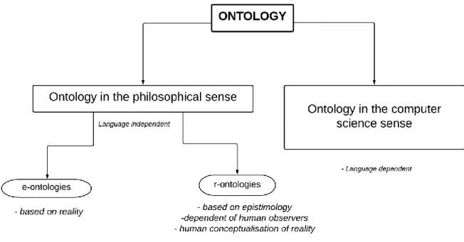
In philosophy, there are different ideas of ontology. Bittner, (2001) differentiated ontology in two unique designs which are Epistemology (e-ontology) and Reality (r-ontology). An e-ontology describes concepts based on human knowledge why an r-ontology describes concepts independent on human expertise as shown in figure 2.1.
13
Figure 2.1. Categorization of ontology (adopted from Bitner, 2001)
Based on the above explanations, this thesis uses the e-ontology and the r-ontology as they find their description of concepts gotten from the epistemology of the people and the reality of what is involved. Such data is acquired from interviews and focused group discussions as well as a review of academic literature.
2.4.
Land administration
An official LADM contains classes related to party, rights, and parcel (Hensen, 1995). Therefore, an ontology should be able to describe such concepts. Party could be a person, or a group of people directly or indirectly involved with the land. Parcel describes the types of land about rights (ownership rights). In understanding land administration, it is essential to understand the relationship between parcel and rights. Parcels are created since they represent boundaries that have unique identifiers. On a cadastral map, plots are designated as legal boundaries of ownership. Therefore, ownership rights also refer to the borders of lands involved (Bitner, 2001). The identifiers could be a unique feature of the parcel such as coordinates.
In this regard, Hennsen (1995) describes the phenomena in land administration in three categories which are a man, parcel and rights as shown in figure 5. He examines the concept of land tenure the acts, rights, and conditions of owning or having access to land or related properties.
14
Figure 2.2. Phenomena in Land administration (Hennsen, 1995)
From the above explanations, it can be noticed that one major category is omitted which is the social concept. Thus, the LADM rarely considers the social activities of people in land policies which has created a significant problem for customary land tenure security. It explains why the primary objective of this study is to model land tenure based on the sociocultural activities of the people.
2.4.1. The land administration domain model
LADM is a broad field, so we focus on the part of LADM that deals in the rights, responsibilities, and restrictions affecting land and the geospatial components. LADM is a conceptual model with the international ISO standard for land administration (Lemmen et al,2015). LADM has three core classes, “Person,” “Right” and “Parcel.” The class name “Person” is changed to “Party,” the class name “Right” has been changed to “RRR” (rights, restrictions, and responsibilities), the class name “Parcel” has been changed to “SpatialUnits” (Hensen, 1995)
15
Figure 2.3 The core classes of LADM (ISO/TC11,2009)
The class “RRR” is the representation of rights, restrictions, and responsibilities. Rights, in this case, may involve ownership rights, land use rights, tenure rights and in the case of Cameroon customary rights (informal). In Cameroon, these rights are defined by the state (formal) and local and traditional authorities (informal or unwritten). Restrictions are the modifications made to the rights, e.g., building on grazing land is prohibited.
The class “Party” refers to a person or a group of people. In Cameroon, it may include individual landowners’ groups of people such as families, social groups, companies, and organizations. It is also possible that a parcel is modeled as a party with rights to another plot if their rights are connected. If a group of people holds different rights to land, they will be modeled separately.
The class “SpatialUnits” refers to land itself, or it could refer to objects on the property such as roads buildings, etc. several spatial objects on the land can form a basic administrative unit (baunit) if they have similar rights, e.g., different plots belonging to the same farm.
2.4.2.
Social tenure domain model (STDM)
STDM is a system that models the relationship between people and land for land administration. Many factors like politics, law, economics, culture, and traditions should be considered for such a system.
16
However, LADM in Cameroon is influenced by politics, economics, and law. The exclusion of the sociocultural components of the people is one of the major shortcomings of the formal land administration system.
Therefore, the modeling process requires the development of an innovative approach of which the STDM is a concrete example. STDM is all about modeling the sociocultural relationships “SocialTenureRelations” between people “Party” and land “SpatialUnits.” In such a model there should be no relationship between “Party and “SpatialUnits” that has no relationship or reference to “SocialTenureRelations” (Lemmen et al. 2007). This domain model can be beneficial in Cameroon as it has numerous ethnic communities with diversified cultures. This thesis model the land tenure of the people of the “grass field” community of Cameroon who can be used to incorporate other cultures in the country and integrated into the formal system.
17
3. Methodology
3.1.
Data acquisition
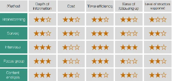
The primary aim of this study involves knowledge modeling. In knowledge modeling, information gathering, and elicitation is very important, this involves data collection, determination of target sources, and the application of suitable methods (Chungoora, 2018). It is, therefore important to consider the technique, depth of information, cost, time efficiency, ease of following up and level of structuring support when carrying out information gathering, and elicitation as seen in figure 3.1 below.
Figure 3.1. Information Gathering (Chongoora, 2018)
From figure 3.1 above the best methods for gathering information for creating an ontology is an interview (for primary data), focus group and content analysis (for secondary data) as they provide in-depth information, are time efficient, easy to follow up and has some high level of structural support and relatively cost-efficient. Primary data was obtained from interviews and questionnaires. It provided first-hand information about the concepts of land and land tenure and its issues in the study area. Secondary data was collected using content analysis (review of literature) of real-life examples and stories of customary land tenure transactions, rules and social conflicts in the area of study. This involved the reading of journal articles, book and getting information from the official websites of the ministry of land tenure and cadaster and some nongovernmental and international organizations working on land modeling.
18
Content analysis or Literature review
For this thesis a total of approximately 15 academic documents were reviewed including research journals and the official LADM document of Cameroon where laws, stories of customary land transactions and social conflicts were examined to gather numerous concepts of land and land tenure in the study area which includes some terms in native language of which reference has been made to. These terms, their explanations, and their recommendations are made available in the appendix.
Interview and questionnaire
As mentioned earlier, primary data is an essential component for the development of the ontology as it provided first-hand information on crucial terms of concepts and their explanations. This information was gotten from the conduction of interviews and the administration of questionnaires.
Due to the distance from the study area, the interview was conducted by phone call or skype some of which were recorded by the approval of the participants. For the questionnaire, an individual with knowledge and experience was trained and given the surveys to administer on the researcher’s behalf Questions for this phase were divided into two groups; questions about land ownership and tenure security, questions about communal land, customary tenure, and practices. The development of the issues was guided by already existing literature which highly contained information about such concepts. Also, questions to enable the separation of participants by age, gender, education level, occupation, and residence were included.
The target group for this phase was individuals identified as heads of families who owned or had access to at least one piece of land, traditional authorities, and officials of the land administration department. A total of 25 participants were involved. Seventeen were administered with questionnaires while eight were interviewed on the phone 80% of which did not accept for their calls to be recorded. The table below describes the participants according to their age, gender, education qualification, occupation.
19
Sex
Male 44.50%Female 55.50%
Occupation
Agriculture 33.30%White collar job 11.10% Business 55.50%
Academic qualification
First school leaving certificate 22.20%Ordinary level 11.10% Advanced level 33.30% University 33.30%
Marital status
Married 66.70%Single 33.30%
Number of children
None 11.10%One and above 88.90%
Age
18 to 50 44.5Above 50 55.5
Table 1. Social data
3.2.
Method for developing the ontology
3.2.1. Collating information
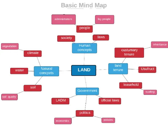
From the information gathering phase, a variety of preliminary concepts affecting land and land tenure in the study areas was extracted. To orderly model these concepts in an ontology, the preliminary concepts were collated in the form of a mind map. The mind map was created with Free Mind which is a free mind mapping software written in Java. Figure 3.2 below shows the mind map that has some general concepts of land which give way for the generation of classes for the ontology.
20 figure 3.2. Mind Map
3.2.2. Initial structuring
Here, the analysis of statements and phrases gotten from the questionnaires, interview, and content analysis was done to derive specific terms related to land and land tenure. A workflow tracker was then created to record the terms and its potential importance in the ontology. The workflow tracker was created using Microsoft excel where the terms, their descriptions, and reference are outlined
3.2.3. Formalization
The formalization phase involves encoding the terms and concepts to form the ontology. For this research, the Protégé application was used for the formalization of the ontology. Protégé is a free ontology editor software written in Java. It consists of deductive classifiers that enable the validation of the consistency of the ontology. Protégé was chosen because it is maintained in the Ontology Web Language (OWL) which makes it open for continuous editing and processing by other open source software and libraries.
21
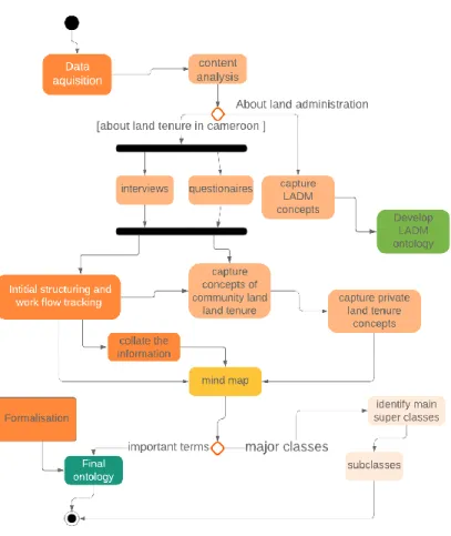
3.3.
Research design
From the above explanations, it is noted the research design has been classified into four main stages which include data acquisition or information gathering, data collation, initial structuring and formalization of the ontology. This is outlined in figure 3.3 below
figure 3.3. Research design
3.4.
The ontology
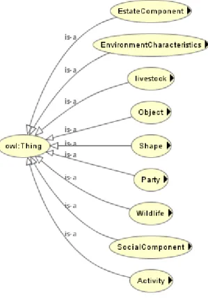
3.4.1. The structure of the Northwest region (Grass field) Ontology
The examination of information gathered indicated that land tenure systems in Cameroon are greatly affected by the natural environment, human activities, government, and sociocultural heritage. These observations were vital for identifying the main classes for the ontology.
The ontology defines nine general superclasses which are the immediate subclass of “THING” as shown in figure 3.4. These classes were obtained from the Southern Kenya Maasai Ontology developed
22
by (Schultz et al., 2017) especially as it had similar observations and concepts as the Northwest region of Cameroon
As mentioned earlier, STDM is all about modeling the sociocultural relationships “SocialTenureRelations” between people “Party” and land “SpatialUnits” which implies that such a model should not have any relationship between “Party and “SpatialUnits” that has no relationship or reference to “SocialTenureRelations.” Therefore, we can identify SocialComponent, Party, and
EnvironemtalCharateristics as the essential superclasses.
Just as in (Schultz et al., 2017), four out of the nine superclasses were identified as in-depth classes as they contained over four subclasses and individuals;
i. Activity, which describes the sociocultural activities about the environment of the area such
as agriculture, pastoralism, hunting, tourism, etc.
ii. EstateComponent, which describes the infrastructural overview and components of the
area.
iii. EnvironmentalCharateristics, which contains subclasses that relate to vegetation, land,
climate, water. The most significant concepts within this class include land use type and land tenure which are subclasses of LandCharacteristics.
iv. socialComponent, which describes the ideas of the traditional and cultural components of
the community.
The rest of the five classes are identified as shallow as they have less than four subclasses and instances;
v. Livestock, which defines several animals kept by the people for commercial or subsistence
purposes.
vi. Party, which describes the categories of people in the community ranging from
administrators to individuals.
vii. Shape, which are geometric figures like lines, polygons, etc. that are of significance to the
culture of the area.
viii. Objects describe the materials used in building infrastructure.
ix. Wildlife outlines the concept of forest animals and birds as a source of food and income
This section also provides a brief description of the broad classes (referee to more details in the appendix). The most important concepts of land are described by categories that represent people, their activities, dwellings about the environment and classes that characterize land tenure and traditions. Therefore, we go
23
through each level and highlight the concepts that are enough to analyses the customary land tenure system and traditions of the community.
Figure 3.4. Superclasses
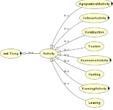
3.4.2. Activity class
The Activity class figure 3.5 shows concepts that describe the sociocultural activities such as agropastoral activities, construction, tourism, farming activity, leasing.
The primary activities in this region are farming, and agropastoral activities as it constitutes the primary source of income for the people thus leasing land is also very profitable as most commercial farmers get access to land thru leasehold. Also, farming is done at a subsistence level by almost 95% of the people. Tourism also forms a significant activity as the regions are characterized by diverse natural features that attract tourist from Europe and other parts of the world. Since most of the people in this region are farmers and grazers, there have been several cases of famer grazer conflicts. Thus, these activity concepts were modeled in a way that the factors including such activities such as climate, land tenure, social components are in cooperated.
24
More, so such activities have also witnessed some land tenure issue with the formal land demonstration system, e.g., most land considered as grazing land by the people is regarded as national land by the state and thus causes some conflicts.
Figure 3.5. Activity Class
3.4.3. EnvironmentalCharacteristic class
The EnvironmentalCharateristic class figure 3.6 encompasses concepts about climate, vegetation, hydrology, and land.
Figure 3.6. Environmental Characteristic class
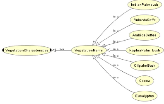
VegeatationCharacteristic
The VegetatiionCharacteristics subclass figure 3.7 refers to concepts that describe the vegetation types and names in the region.
25
Figure 3.7. Vegetation characteristic
The main activity being agriculture and pastoralism has led to the uniqueness of these concepts. Vegetation name in figure 3.8 describes some of the components of the primary and secondary forest. Cocoa, coffee, palm trees are common here as they are the most cultivated crash crops. Palm bushes and eucalyptus forests are also standard as they are important objects used in the construction activity as well as for the demarcation of boundaries which is a fundamental concept of land tenure in the region.
Figure 3.8. Vegetation name
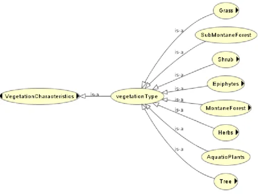
The dense forest such as the Kilum-Ijim forest provides a wide range of flora ranging from grass, herbs, shrubs to trees which offer a variety of non-forest timber products of economic and medical value to the people thus it determines the economic activities as seen in figure 3.9. These activities are carried out based on the customary tenure which is often in conflict with the state thus leading to social unrest in some cases and the weak economy.
26
27 3.10. Tree type
Figure 3.10 above shows vegetation types are of most importance to the people as they exploit in the form of non-timber forest products for commercial purposes. The people have had several conflicts with the legal system as it requires for licenses to be able to exploit them which is nothing close to the customary believes as the people believe they are gifts of nature. This has led to high prices of these products and they become scarce
ClimateCharateristics
ClimateCharateristics in figure 3.11, is a subclass of EnvironmetalCharateristics refer to concepts such as
the rainy and dry season.
28
These characteristics greatly influence activities such as grazing and farming activities. These concepts also cause farmer grazer conflicts as grazers move into the valleys with their livestock in the dry season get water and pasture and thus encroach into farmlands which are mostly in the values and destroy valuable crops. On the other hand, farmers often move upland in the rainy season due to floods and thus encroach into grazing land and convert them to farm. Given the fact that the grazers and farmers often have the squatting and freehold tenure rights on their property in most cases, these conflicts are hardly resolved by the state as the state as they are yet to incorporate such into their system.
LandCharaterisic
LandCharacteristic in figure 3.12 shows the concepts that describe land tenure, land use types and the
quality of land as these significantly influence the activities of people on land. This involves subclasses such as; land tenure, the laws that regulate land use(customary). LandUseType the various ways in which territory is modified such as agriculture, ranching, settlement construction, etc. and LandQuality the properties that influence the land use types on the area such as desert, volcanic soil, etc.
Figure 3.12. Land characteristics
There has been rapid and uncontrolled growth in the peri-urban areas of Cameroon. Bamenda has witnesses such changes which have led to the multiplication of land use types, reductions in agricultural land reduction, grazing land reduction in favor of settlement construction. Wetlands have also been invaded to causing instability in the ecosystem. A study carried out by Kimani et al. in 2017 in the
29
favor of an increase in settlements from 1389ha to 2943ha over the last ten years due to increasing population. This has led to a scarcity of farm and forest land. This has led to the region witnessing several intertribal land conflicts over boundaries in the past years such as the Bambili-Babanki conflicts.
In this regard, the emphasis is laid off the following subclasses of LandUseType; as shown in figure 3.13 and Land tenure in figure 3.14
a. AgriculturalLand used for subsistence (Ankara, bush following, shifting cultivation,
etc.) and commercial farming (market gardening, horticulture, etc.)
b. GrazingLand which comprises of pasture used for feeding livestock and small streams
which provides water for the livestock.
c. NaturalReserve this include national parks, game reserves and protected areas as stated
by the government.
d. The boundary which comprises of objects used for demarcating boundaries like
30 3.13. Land use type
31
3.4.4. EstateComponent class
The EstateComponent in figure 3.15 captures the concepts of human dwelling infrastructure (fon palace, family compounds, community halls, and markets) and agricultural support (farmhouse, food barns, animal barns).
Figure 3.15. Estate component
The Bamenda people are well known for their traditional farming and pastoral activities such as shifting cultivation, bush fallowing, and nomadic grazing. Thus, the infrastructure of the area highly depends on this activity as farmhouses, food barn village markets, and family compounds are very common. All these components depend on the tenure system of the people. Farmhouses and the animal house which are temporal are mostly built with objects like bamboos and wood which can easily be dismantled. This is because most farmers and grazers have the squatting, and leasehold tenure which is temporal and can be taken from them at any time. Family compounds are dwellings where large families reside, the tenure system here is inheritance and hardly secure as other parties might claim ownership to such land including the state. Due to the communal way of life of the people community’s hall and market are very common in the area right of access to all the natives except stranger. However, due to peri-urban
32
growth, there has been increasing in modern infrastructure especially in the university towns of the regions.
3.4.5. SocialComponent class
The social component class in figure 3.16 shows concepts relating to the social structure of the Bamenda people. Bamenda has several tribes, traditional religions, resident types, and administrative units and authorities all of which influences the sociocultural activities of the area and its customary tenure.
3.16. Social component
The most critical concepts related to the society of Bamenda are the tribes, their traditional rulers (ranging from chiefs to quarter heads) and the families found in the tribes as well as other resident types. The activities in this region depend on this social concept as traditional rulers are regarded as the authorities over customary land laws, the families or natives of tribes are the primary farmers (for women) and grazers (for men), strangers often get lease right to the land. However, the government not recognizing these customary land laws at an official level, the cases of disagreements and conflicts between tribes over land use and boundary issues. The current tenure security has been seen to be very insecure in this region.
33
3.4.6. Summary
This section examined an overview of the Northwest community ontology which was designed to capture concepts related to land use and the culture of the people. A full view of the ontology is visualized in the appendix with the descriptions of the ideas.
The information used to create this ontology was derived from the review of literature and interview sessions. The ontology generally describes nine classes adopted from (Schultz et al., 2017) which are activity, environmental characteristics, estate component, livestock, object, shape, party, wildlife, and social element. The social component class is an essential class of the ontology as it describes the nature and compositions of the northwest community about their land tenure system. The environmental characteristics also are very vital as it showed concepts related to land use which is the primary determining factor of the activities and tenure system of the people.
3.5.
Official land administration ontology.
3.5.1. Overview
LADM ontology defines four distinctive classes that relate to each other as shown in figure 3.17. The ontology was developed with the categories based on the International ISO standards as described by Lemmen, (2015). The classes include; RRR (Rights, Restriction and Responsibility), Party, BAUnit and
SpatialUnit. It should be noted each of these concepts is related to the RRR class as they legal system
of Cameroon has clearly defined laws about land use rights, the responsibility of parties on land and the restrictions each spatial unit and the party has. This section briefly describes each of these classes.
34
Figure 3.17. LADM core classes
3.5.2. RRR Class.
The RRR class forms the foundation of land administration in Cameroon.
Figure 3.18. RRR class
Right as seen in figure 3.18 determines the types of land parties can own or have access to. In general, everyone has the right to use public land such as road, beaches, bridges, etc. The right to national land access is mostly by leasehold, profit license, and usufruct, private land ownership is generally
35
recognized by title deeds, or which land that doesn’t provide such act is not termed private land thus most rural dwellers who acquired property from inheritance face problems with the state. Therefore, it can be said that the right to land ownership or access depends on the land categories as described by the state (national land, public land, private land) for example a grazer does not have the right to graze on a hill or unoccupied land without a license.
36 3.19. Right class
37
Restriction in figure 3.20 defines the land use types on each type or category of land. For example, the building houses along main roads (public land) are restricted, it is forbidden to exploit NTFP without a license, it is not allowed for individuals to sell or lease out public land.
Figure 3.20. Restriction class
Responsibility in figure 3.21 refers to the various tasks and actions each party must ensure rights and restrictions are maintained. For example, the general public has the responsibly has the responsibility to protect their private land, responsibility, in this case, is often allocated to different parties depending on their role such as administrators, farmers, grazers, traditional authorities.
38
Figure 3.21. Responsibility class
It is important to note that the RRR class has a direct relationship to the Party, BAUnit. It confirms that the type of land involved determines the rights, restrictions, and responsibility and the individuals involved.
3.5.3. Party class
Party, as shown in figure 3.22, describes the levels of people land administration addresses. It ranges
from administrators, finance institutions, organizations to private individuals. These classes of people are determined by the role they must play on land, and they have defined rights, restrictions, and responsibilities on land.
39
40
3.5.4. BAUnit class
The BAUnit (Basic Administrative unit) class figure 3.23 describes the basic administrative units of land. This class is often located between the RRR classes and the SpatialUnit class because they contain land that might be under the same category or land use type but found in different categories.
Figure 3.23. BA Unit class
The main subclass under this concept is the Basic Property Unit as shown in figure 3.24. The UN and ECE, (1996) define the Basic Property Unit as the extent of land that falls under one class of ownership. It can comprise of one or more adjacent or geographically separate parcel. An excellent example of such types of property is that of the Cameroon Development Cooperation (CDC). The CDC consists of a group of palm, banana, and rubber plantations scattered all over the country but termed as one “CDC land” this property comprises of parties who have their rights, restrictions, and responsibilities to such land. Another typical example is the Government Residential Area (GRA) refers to land reserved only for government administrative employees; such property is in a different area but has the same name. while in a general sense the Basic Administrative unit refers to the boundaries of the various administrative types of the country ranging from a region to a division to a subdivision all of which have administrators and provides right and restrictions
The Northwest, for example, is a region in Cameroon (headed by a governor), and it comprises of seven administrative units called divisions head by a divisional officer (Mezam, Momo, Menchum, Boyo, Ngogentungia, Bui, Ndonga man tun). Each of this division has subdivisions and tribe with defined boundaries.
41
figure 3.24. Basic property unit
3.5.5. spatial unit class
The SpatialUnit class in figure 3.25 in the case of Cameroon refers to the various categories of land according to the ordinance lawi.
Figure 3.25. Spatial unit class
It should is noted that the SpatialUnit class contains spatial sources which include boundaries, and basic administrative units as shown in figure 3.25 above. It implies that land belongs within a specific radius
42
or geographical location and must be part of an administrative unit. The figures below describe the different categories of land
Figure 3.27. Private land
43
Figure 3.29. National land
3.5.6. Summary
This section presented an overview of the LADM of Cameroon (full version in the appendix). The information used to create this ontology is obtained from the official website of the Cameroon Ministry of State Property and Land tenureii.