Brazilian Journal of Geophysics (2019) 37(4): 419-434 © 2019 Sociedade Brasileira de Geofísica ISSN 0102-261X
www.rbgf.org.br
DOI: 10.22564/rbgf.v37i4.2019
HYDROGEOLOGICAL CHARACTERIZATION OF THE AQUIFERS OF THE SALITRE REGION
THROUGH STABLE ISOTOPES (
δ
D AND
δ
18O) AND GEOCHEMISTRY
Christian Pereira Lopes dos Santos
1, Luiz Rogério Bastos Leal
2, Antonio Expedito Gomes de Azevedo
3,
Maria do Rosário Zucchi
3and Alan Robert Dutton
4ABSTRACT.The important aquifers of the Salitre basin are encompassed within the geological framework of the metasedimentary rocks of the Chapada Diamantina
Group and in the carbonate rocks of the Una Group and Caatinga Formation. For fifty five water samples from carbonate aquifers,δD values varied from −43‰ to
−10‰, andδ18O values from −5.9‰ to −3.3‰, with high concentrations of dissolved total salts. The variability allowed us to discern three process of salinization:
i) samples with more negative isotope values are produced primarily by transpiration and/or dissolution in the evaporitic rocks; ii) samples with less negative isotopic
values indicate that evaporation is predominant; and iii) samples from metasedimentary aquifers, with low concentrations of dissolved total salts andδD values ranging
from −36‰ to −20‰ andδ18O values from −5.4‰ to −3.5‰ indicated low evaporation. The piezometric map indicated that the groundwater flow flux is from
both the east and west towards the center of the basin and that the general direction of surface water flux is from south to north, where the water level is closer to the surface.
Keywords: carbonate rocks, semiarid region, hydrochemistry, stable isotopes, karst aquifers.
RESUMO.Os aquíferos importantes da bacia do Salitre estão abrangidos dentro do arcabouço geológico metassedimentares do Grupo Chapada Diamantina e nas
rochas carbonáticas do Grupo Una e da Formação Caatinga. Para cinquenta e cinco amostras de água dos aquíferos carbonatados, os valores deδD variaram de −43 ‰
a −10 ‰ e os valores deδ18O de −5,9 ‰ a −3,3 ‰, com altas concentrações de sais totais dissolvidos. A variabilidade indica três processos de salinização: i)
amostras com mais valores de isótopos negativos são produzidas primariamente por transpiração e/ou dissolução nas rochas evaporíticas; ii) amostras com menos valores isotópicos negativos indicam que a evaporação é predominante; e iii) amostras de aquíferos metassedimentares, com baixas concentrações de sais totais
dissolvidos e valores de D variando de −36 ‰ a −20 ‰ e valores deδ18O de −5,4 ‰ a −3,5 ‰ indicaram pouca evaporação. O mapa piezométrico indicou que o
fluxo subterrâneo é tanto do leste quanto do oeste em direção ao centro da bacia e que a direção geral do fluxo de superfície é do sul para o norte, onde o nível freático está mais próximo da superfície.
Palavras-chave: rochas carbonáticas, região semiárida, hidroquímica, isótopos estáveis, aquíferos cársticos.
Corresponding author: Maria do Rosário Zucchi
1Instituto Federal de Educação Ciência e Tecnologia Baiano, Campus Catu, Rua Barão de Camaçari, 118, Centro, 48110-000, Catu, BA, Brazil – E-mail: [email protected]
2Universidade Federal da Bahia, Instituto de Geociências, Campus Universitário de Ondina, Ondina, 40170-115, Salvador, BA, Brazil – E-mail: [email protected] 3Universidade Federal da Bahia, Pós-Graduação em Geofísica, Rua Barão de Geremoabo, S/N Federação, 40050-090, Salvador, BA, Brazil – E-mails: [email protected],
4University of Texas at San Antonio, Department of Earth and Environmental Sciences, 6900 N, Loop 1604 W, San Antonio, TX 78249-0663 – E-mail: [email protected]
INTRODUCTION
The Salitre region is among the poorest regions in northeastern Brazil (Fig. 1). The rural and urban populations of the area depend largely on water from aquifers and from ephemeral rivers, which is also used for irrigation and small industrial activities. However, little surface water is available, and the waters are highly saline, especially during certain seasons (Martins, 1986; Bastos Leal et al., 2005; Lima et al., 2005; Santos, 2008). As a result, people in the region are subject to a seasonal shortage of potable water and rely heavily on groundwater. The pressure to find new sources of freshwater has been increasing over the last 10 years due to growth in the population and areas under irrigation, as well as the initiation of new mineral industries. This has caused frequent conflicts over water among intensive agriculture, industry and domestic use (Bastos Leal et al., 2005, Brito et al., 2005).
In recent years, several aquifers in Bahia State have been studied according to the framework of the National Council of Scientific and Technologic Development (CNPq) and the Center for Research in Geophysics and Geology at the Universidade Federal da Bahia, Brazil (CPGG-UFBA) to improve the knowledge of these aquifers and increase the water supply. The first detailed hydrogeological study in the Salitre region included fieldwork in the summers of 2004 and 2005 (Lima et al., 2005; Santos, 2008). The applied methods include hydrogeological mapping, geophysical investigation, hydrochemical and isotopic sampling and analyses. To improve the management of these aquifers using scientific rather than political criteria, more investigation is needed.
Hydrochemical and environmental isotope techniques have been increasingly applied to water resource management and can help provide a better understanding of the aquifer recharge, dissolution of minerals within the bedrocks, water mixing and evaporation process, and spring discharge. In addition, they are essential for defining groundwater hydrodynamic models (Clark & Fritz, 1997; Thomas & Rose, 2003; Marfia et al., 2004; Shanyengana et al., 2004; Barbieri et al., 2005).
The main goals of this study are: a) to analyze geological features, hydrochemistry and stable isotopes (18O and D)
to understand the recharge, salinization and possible mixing processes of groundwater; and b) to develop a conceptual hydrogeological model of the aquifer system. The results of this work will improve our understanding of both the hydrogeological dynamics of the aquifers in the Salitre basin and the process of water resource management and protection. They will also offer an assessment of the quality of water for human, irrigation and industrial uses.
GEOGRAPHICAL AND CLIMATIC OVERVIEW
The study area is located in the northeastern region of Brazil in the semiarid climate zone, and includes a catchment of approximately 14,500 km2. The Salitre river and its tributaries form the principal
drainage network of the study area. The morphology of the region is largely dependent on the geological structure, which includes elevations of approximately 1,200 m above sea level in the siliciclastic rocks of Chapada Diamantina Group. The elevations are between 500 and 600 m in carbonatic sequence rock outcroppings in the central part of the basin, and the minimum elevation is approximately 400 m, in the northern region where the Salitre basin is bounded by the São Francisco river valley (Fig. 1).
The mean annual precipitation in the Salitre region ranges from approximately 450-500 mm/yr. The dry season is between June and January, but in the south of the region, the precipitation can reach 1000 mm/yr. Average annual temperature is 26°C, and daily temperatures range between 18°C and 38°C and the potential evapotranspiration demand is between 1700-2200 mm/yr (Martins, 1986).
This semiarid region of Brazil has an interannual variation in climatic conditions, with some years experiencing extremely dry summers where water deficits can range from 100 mm/yr in the south to over 1,700 mm/yr in the drier north (Martins, 1986). In these climatic conditions, evaporation is important in controlling the chemical signature of groundwater. However, the different composition of the rocks in this region and the occurrence of soluble minerals (ex: calcite, dolomite, gypsum) can provide another source of the ions dissolved in groundwater. (Ettayfi et al., 2012; Sánchez et al., 2015; Salles et al., 2019).
GEOLOGICAL AND HYDROGEOLOGICAL FRAMEWORK The oldest geologic unit, representing 3% of the surface of the study area, is formed by an Archean-Paleoproterozoic granite-gnaisse complex and supracrustal rocks located in the extreme north of the basin (Fig. 1). These oldest rocks are covered by Mesoproterozoic sedimentary rocks represented by the Chapada Diamantina Group, which forms a QPC (Quartzit-Pelite-Carbonate) association. The covering layer comprises distinct metaconglomerate, metasandstone and metacarbonate lithofacies associated with alluvial fan, fluvial, desertic tidal flat, deltaic and marine depositional systems (Pedreira, 1997). There are economically important deposits of iron and sulfides associated with this QPC sequence.
The Neoproterozoic sequence of the Una Group overlies the Mesoproterozoic rocks of the Chapada Diamantina. It consists
SANTOS CPL, LEAL LRB, AZEVEDO AEG, ZUCCHI MR & DUTTON R
421
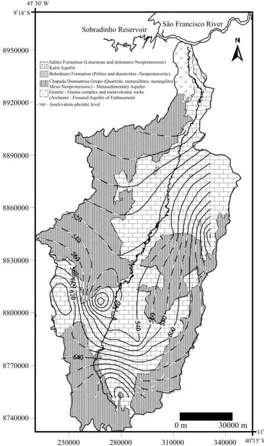
Figure 1 – a) Location of study area and distribution of carbonatic (karst) sequences in Bahia, Brazil and Geological / Hydrogeological domains of the Salitre watershed;
b) Hydrogeologic cross-section along transect in the south (A-A’) and north (B-B’) of the basin.
of the diamictite and pelites of the Bebedouro Formation at the base, followed by the predominantly marine carbonates of the Salitre Formation (Fig. 1). Carbonate sequences of the Salitre Formation are well exposed in the study area and its correlative units in the Bambuí Group have been part of an extensive Neoproterozoic platform (>300,000 km2), with sedimentation
commencing during the transgression sea over much of the São Francisco Craton between 600 and 670 Ma (Misi & Kyle, 1994; Misi & Veizer, 1998).
The carbonatic sequence is formed by succession sedimentary lithofacies composed (from bottom to top) by argilaceous dolostone, laminated dolomitic limestone, evaporitic limestone, marl, oolitic limestone and black limestone resulting from the two transgressive-regressive cycles. The most economically important contents are the host phosphatic stromatolites and Pb-Zn sulfide mineralizations associated with stratiform and stratbound pyrite, spharelite and galene in the associated with the dolomitic limestone layers (Misi & Kyle,
1994; Misi & Veizer, 1998). On the other hand, geomorphological and isotopic studies ofδ34S in the carbonatic rocks in the north
of the Salitre region show that cave development was mostly caused by sulfuric acid dissolution due to pyrite oxidation during the Tertiary period (Auler, 1999).
The present structural configuration of the Salitre basin, which is formed of a large syncline cuted by fracture systems and flexural folds in the northestern segment, was developed during a collision related to Brasiliano/Pan African tectonic cycle about 650-500 Ma (Lagoeiro, 1990; Brito Neves et al., 1999) (Fig. 1). The man aligned faults and fractures, mostly NNE-SSW, along the Salitre river strike may represent basement structures that were reactivated during carbonatic sedimentation (Alvarenga & Dardenne, 1978). In the vadose zone these structures act as infiltration pathways for the recharge of deep aquifers, and they are a major flow channel within the satured zone.
The main aquifers in the Salitre watershed are represented by rocks of the Chapada Diamantina Group, which form a confined, fractured aquifer that occupies 46% of the basin and by the carbonatic sequence of the Salitre Formation, which is a unconfined karst aquifer that occupies approximately 51% of the basin and creates the majors reservoir in the study area. The rocks of the Bebedouro Formation act as an aquitard between the aquifer systems (Fig. 1). The groundwater flow is generally controlled by topography and faults, and it is congruent with the major rivers and their tributaries.
The recharge of the Chapada Diamantina fractured aquifer occurs by rainfall in the high mountains. More than 90% of the wells currently pump less than 30 m3/h, and in phreatic
conditions the water table is 20 m below the surface.
Figure 2 shows the groundwater elevation contours from Salitre watershed. These maps indicate that groundwater flow goes from the east and west to the center of the watersheds and that the general direction of surface flow is from south to north where the phreatic level in the aquifer is closer to the surface.
Geophysical electrical resistivity studies in the karst aquifer show that it has thickness ranges from 70 m in the north segment to 250 m in the south (Lima et al., 2005). The karst aquifer has allogenic groundwater recharge associated with cross-formational flow from underlying Mesoproterozoic siliciclastic rocks in the low mountains surrounding the karst basin and autogenic recharge in the central region of the aquifer associated with tectonic and karst structures (fractures, sinkhole, vertical shafts and conduits). There is no perennial surface
drainage on the carbonatic rocks. The only perennial river drains from the Chapada Diamantina Group’s rocks and undergoes diffuse infiltration into the karst aquifer.
The principal discharge zone from the aquifer is the Pacuí Spring, with a discharge of 0.23 m3/s as measured in January
1994 (Auler, 1999). Well productivity in the karst aquifer ranges from 1 to 50 m3/h, and approximately 50% of the wells present
pumping less than 10 m3/h. However, in the region of the aquifer
where the karstification is more developed and in discharge zones, the pumping rates can be as high as 150 m3/h (Bastos
Leal et al., 2005).
SAMPLES AND ANALYTICAL PROCEDURES
Seven superficial water and forty-nine groundwater samples were collected from wells and a spring associated with the karst (41 samples) and fractured (8 samples) aquifers and from drainage during the months of November 2004 and 2005. The water for major cation and anion analyses was stored in 1000-ml high-density polyethylene bottles with no headspace, filtered through 0.45 µm Millipore filters, acidified with nitric acid
(cations only) to pH < 2 before bottling and then refrigerated. The multi-parameter instrument (Horiba U-50 series) automatically records temperature, pH and electrical conductivity of water in situ, with resolutions of 0.1oC, 0.01 pH and 1 µs/cm,
respectively. Cation chemistry was determined by inductively coupled plasma (precision, ±1%) and anions were analyzed by ion chromatography (precision, ±1%). The total dissolved solids (TDS) were calculed by summing concentrations or major ions.
For stable isotope determinations, a 50-ml glass bottle was filled and the oxygen and hydrogen isotopes were measured using a mass spectrometer, model DELTA PLUS (TermoFinningan). Oxygen isotope ratios were determined by the CO2equilibration
method with precision of ±0.1 ‰. (Epstein & Mayeda, 1953). Hydrogen isotope ratios were determined by Cr-reduction method (Brand et al., 2000) with precision of ±1 ‰. BothδD andδ18O
measurements were standardized using Vienna Standard Mean Ocean Water (VSMOW).
RESULTS AND DISCUSSION
Sampling locations, well data and analytical results are presented in Tables A1 and A2 in the Appendix.
SANTOS CPL, LEAL LRB, AZEVEDO AEG, ZUCCHI MR & DUTTON R
423
CHEMICAL COMPOSITION
The groundwater samples showed the occurrence of two different hydrochemical groups. In the fractured aquifer, the total dissolved solids (TDS) ranged from 108 mg/l to 334 mg/l, but locally exceeded 1,500 mg/l (sample TCM-67). This was reflected by the electrical conductivity (EC) values of the samples, which varied from 222 to 600 µS/cm, except in sample TCM-67, which had a value of 1,800 µS/cm (Table A1). The water samples from the karst aquifer were characterized by higher total mineralization, ranging from 578 mg/l (sample TCK-07) to 3,236 mg/l (sample TCK-60). The EC of these samples was also higher and varied from 900 to 4,800 µS/cm, which was consistent with the higher salinity of the karst groundwater (Table A1). All of the water samples were acid to slightly alkaline. Their pH indices were uniform and ranged between 6.0 and 7.6 (Table A1). The temperatures of groundwater samples measured in the field were between 26°C and 29°C.
Ca and Mg ions were the dominant cations in samples from the metasedimentary aquifer and their concentrations varied widely, while HCO3 was a dominant anion, except in sample
TCM-67, which had SO4as its dominant anion (Table A1). The
Ca content ranged from 27 mg/l (sample TCM-03) to 295 mg/l (sample TCM-67). The Mg content was between 17 mg/l (sample TCM-03) and 101 mg/l (sample TCM-67). The concentration of HCO3ranged from 97 mg/l (sample TCM-66) to approximately
231 mg/l (sample TCM-10). These ion compositions placed the water from the fractured aquifer in a Ca-Mg-HCO3type (Fig. 3).
The normal content of SO4ion ranged from 3.4 to approximately
24 mg/l, but in sample TCM-67 it was 1,188 mg/l, indicating a Ca-SO4composition type for this water sample. Cl and Ca ions
are dominant in the samples from the karst aquifer. Thus, the waters were of Ca-Cl type (Fig. 3). The Ca content ranged from 66 to 354 mg/l, and Cl from 63 to 1,300 mg/l (Table A1). The Mg content varied from 31 to 94 mg/l, and the SO4from 22 to
158 mg/l. The HCO3content varied from 110 to 447 mg/l while
NO3content ranged from 1.5 to 19 mg/l. The contents of K and Na
varies from 4.1 to 28 mg/l and from 88 to 308 mg/l, respectively. The content of these elements in the waters from the karst aquifer was higher than in those from the fissured aquifer (Table A1).
Slightly elevated nitrate concentrations, which were above the limits set for human use (10 mg/l; MS 2914) were found in several samples in the karst aquifer (ex. TCK-70 and TCK-74; Table A1), suggesting contamination derived from pollution sources such as domestic effluents, septic tanks, and waste from an unlined municipal-landfill in the region.
Figure 3 – Piper diagram showing the ionic composition of samples in Salitre
watershed; circle samples from fractured aquifer and square samples from karst aquifer.
In the Mg vs Ca plot, it is apparent that the karst aquifer contains significantly more calcium and magnesium than fissured aquifer, which reflects the predominant rock type. The concentrations increase during the underground flow, which can be explained by additional mineral dissolution and mixing processes within the aquifers (Fig. 4a). This behavior can also be observed in the strong correlation between these ions and TDS in both aquifers (Figs. 4b and 4c).
The high Ca and Mg content observed in sample TCM-67, which was collected in the metasedimentary aquifer, most likely result from the dissolution of the carbonate rocks of the Caboclo Formation that is associated with the Chapada Diamantina Group (Pedreira, 1997). In contrast, some authors explain the higher SO4concentration in groundwater (e.g., Hem, 1992; Motyka et
al., 2005; Charideh & Rahman, 2007) suggest that the high concentration of sulfate ions can originate from infiltration of water that is enriched in SO4 by pollution, pyrite oxidation or
dissolution of evaporate rocks. However, in the region where this sample was collected, there are no industrial activities, important urban occupation or occurrence of the evaporate rocks, but on the other hand the occurrences of the sulfured mineral associated with the Chapada Diamantina Group and Salitre Formation (Pedreira, 1994; Misi & Veizer, 1998). This suggests that the high content of sulfate in sample TCM-67 is most likely associated with the dissolution of sulfured minerals (ex: pyrite) that occurs in these parts of the Chapada Diamantina Group.
SANTOS CPL, LEAL LRB, AZEVEDO AEG, ZUCCHI MR & DUTTON R
425
Figure 4 – The relationship among ions and total dissolved salts in groundwater
of the Salitre watershed: a) magnesium and calcium; b) magnesium and total dissolved salt; and c) calcium and total dissolved salt.
Figure 5 – Relationships between major ions: a) sodium and chloride; b)
calcium and chloride; and c) magnesium and chloride in groundwater of the Salitre watershed.
The relationship between Cl and the major cations Na, Ca and Mg (Fig. 5) indicate that there is no mixing between the groundwater of these aquifers. The lowest Cl concentrations in the fractured aquifer reflect water recharge from the high altitudes and regional rainwater, with possible enrichment by evaporation processes. The highest Cl concentrations are associated with the karst aquifer and are derived mainly from the evaporation processes, as originally suggested by Bastos Leal et al. (2005), Santos (2008).
The plots of Cl/SO4 versus SO4 ion in both aquifers
show a negative slope, where the concentrations of dissolved sulfate and chloride ions are inversely related, especially in karst groundwater (Fig. 6). This higher concentrations of sulfate in the
groundwater of the karst aquifer indicates a gypsum dissolution and/or oxidation of pyrite, as suggested by Guerra (1986) and noted by Valle & Karmann (2005) while studying the Una karst in the Irecê region. The relative scatter of the data most likely reflects the evaporative concentration of sulfate associated with reactions within the bedrock.
The importance of evaporative concentration, is also demonstrated by the Na/Cl ratios of the groundwater samples, which varied from 0.41 and 0.73 in fractured aquifer samples and between 0.15 and 0.59 in the samples from the karst aquifer, except in the sample TCK-04, in which the ratio was 1.67 (Fig. 7). This range and the negative slope of the data imply that chloride also enters the karst groundwater from rain. Additionally, the
Figure 6 – Relationship between the Cl/SO4ratio and SO4concentration in
groundwater of the Salitre watershed.
Figure 7 – Relationship between the sodium/chloride ratio and chloride
concentration in groundwater of the Salitre watershed.
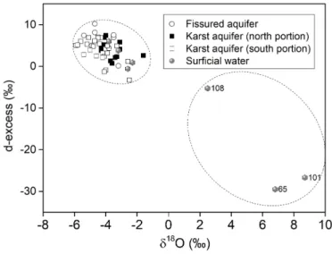
Figure 8 – d-excess versusδ18O for surface water and groundwater in the Salitre watershed.
variation in the cation-anion proportion within each system can explained by differences in residence time and the degree of rock-water interaction.
STABLE ISOTOPE GEOCHEMISTRY
The stable isotopes of oxygen and hydrogen are generally considered to be transported conservatively in shallow aquifers, due to the prevalence of high rock-water ratios and an absence of significant evaporation. However, in the case of the Salitre basin, with its high temperatures (mean 26oC) and evaporation
(1700-2200 mm/year), it is likely that rainfall evaporates before and even after infiltration occurs. Therefore, the isotopic signatures should be combined with other fingerprints to evaluate the level of interaction between groundwater and soluble minerals and the salinization process.
The isotopic composition of the dam water in the study region was highly enriched by evaporation, withδ18O ranging
from 2.5 to 8.7 ‰ andδD from 15 to 43 ‰ (Table A2). On
the other hand, the isotopic compositions of the spring and Salitre river water basin are relatively depleted in stable isotopes, -1.6 to -3.8 ‰ for δ18O and -10 to -26 ‰ forδD. Figure 8
shows diagram d-excess versusδ18O. In this diagram almost
surficial water and groundwater samples are closer together, except for surficial water 108, 101 and 65 means that evaporation enrichment isotopic has occurred.
The groundwater of the fissured aquifer ranged from -3.2 to -5.4 ‰ forδ18O and from -20 to -36 ‰ forδD (Table A2).
According to the isotopic composition, the karst groundwater samples were divided in two groups. The first group consisted of the groundwater from the south the Salitre basin and presented
SANTOS CPL, LEAL LRB, AZEVEDO AEG, ZUCCHI MR & DUTTON R
427
Figure 9 –δD versusδ18O for groundwater in the Salitre watershed. Figure 10 – Relationship betweenδ18O and Cl in the groundwater of the Salitre
watershed.
large variation in the isotopic composition, withδ18O ranging
between -2.5 and -5.9 ‰ while theδD ranged between -20 and
-43 ‰. In the second group, groundwater from north area of the region, isotopes varied less and the enrichment, -3.1 to -4.7 ‰ forδ18O and -19 to -31 ‰ forδD, suggests more evaporation in
this part of the Salitre basin (Table A2).
The plot of all the groundwater isotope data on theδ18O-δD
diagram shows a line below the GWML (δD=6.5∗δ18O-2.4),
suggesting that evaporation has enriched the water in heavy isotopes (Fig. 9). Additionally, the relationship betweenδ18O and δD in groundwater from the fissured and karst aquifers indicate
the same hydrological origin for both and that recharge occurs during the major rainy season.
Similar indicated in the relationship between Cl and the major cations (Na, Ca and Mg), the Cl-δ18O relationship reveals
that the karst groundwater group has elevated salinity with relatively narrow isotopic enrichment (Fig. 10). This confirms that the primary cause of the salinity in the groundwater of the karst aquifer is its interaction with the carbonatic sequence and the secondary cause is evaporation. In contrast, the narrow Cl variation of groundwater from the fissured aquifer, and its increased δ18O confirm an acute evaporation process in the
Salitre watershed.
Figure 11 shows isolines of deuterium concentrations created by a kriging interpolation in SURFER software. This map shows that water samples from the south of the basin are isotopic depleted, while in the north they are enriched in heavy isotopes. This trend is related to the hydric balance as seen in the piezometric map of the basin, with higher precipitation, lower
evaporation and greater depths of the phreatic level in the south and lower precipitation, higher evaporation and shallow phreatic levels in the north.
CONCLUSION
The groundwaters that recharge the drainage axis of the Salitre river are a mix of precipitation collected in the metasedimentary rocks of the Chapada Diamantina Group and water that circulates through the carbonate rocks of the Salitre karst aquifer.
The chemical and isotopic data show that the main drivers of salinity in the region are evaporation and secondarily chemical interactions with the carbonate rocks.
The hydrological budget of Salitre basin, which has about 500 mm/year of precipitation and potential evapotranspiration of more than 2000 mm/year, defines the basin as semiarid. The recharge of the aquifers is therefore a result of precipitation that escapes the intense evaporation and is collected in fractures and joints.
Only in surface water, such as in dams, is evaporation dominant and able to cause enrichment in heavy isotopes and dissolved salts.
In samples from wells close to the river and from wells where the aquifer has a shallow open surface, there was18O and
D enrichment due to evaporation.
For samples from the karstic aquifer, which have high salinity and low D and18O values, transpiration is the dominant
process. Transpiration leaves behind the salts without isotopic fractionation.
Through analyses of the piezometric lines, the depth of the phreatic level and the deuterium maps, it was possible to
SANTOS CPL, LEAL LRB, AZEVEDO AEG, ZUCCHI MR & DUTTON R
429
understand that the underground flow is from east and westtoward the center of the basin, and the it generally flows from south to north. The water in the north part of the basin is more enriched in heavy isotopes and dissolved salts.
The results of this work contribute to a better understanding of the hydrogeological dynamics that underlie water quality as evaluated for human, irrigation and industrial use.
ACKNOWLEDGMENTS
The authors thank the Conselho Nacional de Desenvolvimento Científico e Tecnológico – CNPq (National Council of Scientific and Technologic Development – Process No. 475655/03-6) and Coordenação de Aperfeiçoamento de Pessoal de Nível Superior, Brazil - CAPES (Process No. 518/05 and BEX-0030/06-6) for financial support of the present work, as well as international cooperation between the Universidade Federal da Bahia and University of Texas at San Antonio.
REFERENCES
ALVARENGA CJS & DARDENNE MA. 1978. Geology of Bambuí and Paranoá Groups on the Serra de São Domingos, Minas Gerais, Brazil. In: Proceedings of XXX Cong. Bras. Geol. Recife, PE, Brazil. August 1978, 2: 546-556. [in Portuguese].
AULER AS. 1999. Karst evolution and paleoclimate of eastern Brazil. PhD Thesis, University of Bristol, England. 268 pp.
BARBIERI M, BOSCHETTI T, PETITTA M & TALLINI M. 2005. Stable isotope (2H, 18O and87Sr/86Sr) and hydrochemistry monitoring for groundwater hydrodynamics analysis in a karst aquifer (Gran Sasso, Central Italy). J. Appl. Geochem., 20: 2063-2081.
BASTOS LEAL LR, SILVA HM, LUZ JAG & LIMA OAL. 2005. Hydrogeology of karst aquifers on the São Francisco Craton, Bahia State. Implications for management of groundwater. In: III Simp. Craton do São Francisco. Short Paper, Salvador, BA, Brazil. October 2005. p. 370-372. [in Portuguese].
BRAND WA, AVAK H, SEEDORF R, HOFMANN D & CONRADI T. 2000. New methods for fully automated isotope ratio determination from hydrogen at the natural abundance level. Geophys. Prospect., 28: 967-976.
BRITO LTL, SRINIVASAN VS, SILVA AS, GHEYI HR, GALVÃO CO & HERMES LC. 2005. Influence of anthropic activities on water quality of Salitre river basin. Rev. Bras. Eng. Agrícola e Ambiental, 9(4): 596-602. [in Portuguese].
BRITO NEVES BB, CAMPOS NETO MC & FUCK RA. 1999. From Rodinia to Western Gondwana: an approach to the Brasiliano-Pan African Cycle and orogenic collage. Epis. J. Intern. Geosc., 22(3): 155-166.
CHARIDEH A & RAHMAN A. 2007. Environmental isotopic and hydrochemical study of water in the karst aquifer and submarine springs of the Syrian coast. Hydrogeology Journal, 15(2): 351-364.
CLARK ID & FRITZ P. 1997. Environmental isotopes in Hydrogeology. Lewis, New York, 311 pp.
EPSTEIN S & MAYEDA TK. 1953. Variation of the18O/16O ratio in natural waters. Geochem. et Cosm. Acta, 4: 213-224.
ETTAYFI N, BOUCHAOU L, MICHELOT JL, TAGMA T, WARNER N, BOUTALEB S, MASSAULT M, LGOURNA Z & VENGOSH A. 2012. Geochemical and isotopic (oxygen, hydrogen, carbon, strontium) constraints for the origin, salinity, and residence time of groundwater from a carbonate aquifer in the Western Anti-Atlas Mountains, Morocco. Journal of Hydrology, 438-439: 97-111.
GUERRA AM. 1986. Karstification process and hydrogeology of Bambuí Group on Irecê Region, Bahia. PhD Thesis, Universidade de São Paulo. SP, Brazil, 267 pp. [in Portuguese].
HEM JD. 1992. Study and interpretation of the chemical characteristics of natural water. United States Geological Survey, Water-Supply Paper 2254: 263 pp.
LAGOEIRO LE. 1990. Study of deformation of the Una Group carbonatic sequence on the Irecê region, Bahia. MSc. Thesis, Universidade Federal de Ouro Preto, MG, Brazil, 165 pp. [in Portuguese].
LIMA OAL, BASTOS LEAL LR & LUZ JAG. 2005. Geology and geophysics characteristics of the aquifers on Salitre basin, Bahia State. In: III Simp. Cráton do São Francisco. Short Paper, Salvador, BA, Brazil. October 2005, p. 366-369. [in Portuguese].
MARFIA AM, KRISHNAMURTHY RV, ATEKWANA EA & PANTON WF. 2004. Isotopic and geochemical evolution of ground and surface waters in karst dominated geological setting: a case study from Belize, Central America. J. Appl. Geochem., 19: 937-946.
MARTINS MR. 1986. Evaluation of water resources on the watershed of the Bahia State, Salitre watershed. Governo do Estado da Bahia. Publicação Especial. Centro de Estatística e Informação, v.1, 101 pp. Salvador, BA, Brazil. [in Portuguese].
MISI A & KYLE JR. 1994. Upper Proterozoic carbonate stratigraphy, diagenesis, and stromatolitic phosphorite formation, Irecê Basin, Bahia, Brazil. J. Sediment. Res., 64: 299-310.
MISI A & VEIZER J. 1998. Neoproterozoic carbonate sequences of the Una Group, Irecê Basin, Brazil: chemostratigraphy, age and correlations. Precamb. Res., 89: 87-100.
MOTYKA J, GRADZINSKI M, BELLA P & HOLÚBEK P. 2005. Chemistry of waters from selected caves in Slovakia – a reconnaissance study. Environ. Geol., 48: 682-692.
PEDREIRA AJ. 1994. The Espinhaço Supergroup in the Center-Eastern Chapada Diamantina, Bahia State: Sedimentology, Stratigraphy and Tectonics. PhD Thesis, Universidade de São Paulo. SP, Brazil. 126 pp. [in Portuguese].
PEDREIRA AJ. 1997. Deposicional systems in the Chapada Diamantina Sequence, Centro Oriental, Bahia. Rev. Bras. Geoc., 27(3): 229-240. [in Portuguese].
SALLES LQ, BASTOS LEAL LR, PEREIRA RGFA, LAUREANO FV, NASCIMENTO SAM, ZUCCHI MR & BARBOSA NS. 2019. Hydrogeochemical and isotopic tools (δ18O and δ2H) applied to understanding the processes of groundwater salinization in Proterozoic carbonate aquifers: Evidence from the semi-arid region of northeastern Brazilian. Anuário Inst. Geoc., 42(2): 117-125. [in Portuguese]. SÁNCHEZ D, BARBERÁ JA, MUDARRA M & ANDREO B. 2015. Hydrogeochemical tools applied to the study of carbonate aquifers:
examples from some karst systems of Southern Spain. Environ. Earth Sci., 74: 199-215.
SANTOS CPL. 2008. Analysis of salinization processes of the waters of the Salitre river basin by environmental tracers. PhD Thesis on Geophysics, Universidade Federal da Bahia. BA, Brazil. 105 pp. [in Portuguese].
SHANYENGANA ES, SEELY MK & SANDERSON RD. 2004. Major-ion chemistry and ground-water salinization in ephemeral floodplains in some arid regions of Namibia. J. Arid. Environ., 57: 211-223. THOMAS J & ROSE T. 2003. Environmental isotopes in Hydrogeology. Environ. Geol., 43(5): 532.
VALLE MA & KARMANN I. 2005. Hydrochemical of Una Group in the Irecê basin, Bahia State: An example of acid sulfur action in karst system. In: III Simp. Craton do São Francisco. Short Paper, Salvador, BA, Brazil. October 2005, p. 377-380. [in Portuguese].
Recebido em 25 de abril de 2019 / Aceito em 28 de novembro de 2019 Received on April 25, 2019 / Accepted on November 28, 2019
SANTOS CPL, LEAL LRB, AZEVEDO AEG, ZUCCHI MR & DUTTON R
431
APPENDIX Table A1 – Chemical composition of groundwater in the Salitre basin of the Bahia State, Brazil. ID No Sample Location Coordinate T EC pH TDS Ca Mg Na K HCO 3 SO4 Cl NO 3 Lat. S Long. W °C µ S/cm mg/l mg/l mg/l mg/l mg/l mg/l mg/l mg/l mg/l Metasedimentar y aquifer 1 TCM-03 Caat. do Moura (aw) 10.9763 40.7027 27.7 334 7.2 206 27 17 10 5 140 3 18 0.2 24 TCM-10 Engenho Pacuí (s) 10.1134 40.8169 29.4 600 7.0 334 66 25 14 3 231 25 32 1.3 3 TCM-61 Faz. Lage (w) 11.0673 40.7511 27.0 350 7.2 198 30 20 14 7 140 7 34 0.2 7 TCM-66 Bela (aw) 10.4311 41.1844 27.6 222 6.5 108 18 11 6 7 97 5 8 0.2 8 TCM-67 Lagoa do Anjico (w) 10.5393 41.2838 27.9 1800 6.4 1761 295 101 16 4 206 1188 34 0.6 18 TCM-75 Tabua (aw) 11.0685 41.1231 28.0 500 6.3 289 31 19 27 11 126 6 66 0.6 Karst aquifer 2 TCK-02 Faz. Bebedouro (w) 10.9763 40.7639 27.9 2100 7.5 1318 190 57 115 7 279 95 379 10.8 5 TCK-05 Poço V erde (d) 11.0022 41.0755 27.0 1500 7.0 1030 165 45 58 8 291 44 248 9.9 9 TCK-23 Faz. M. Chapéu (w) 10.8573 41.4545 26.4 1500 6.5 1118 159 59 80 5 349 136 170 14.5 10 TCK-70 Lagoa dos 33 (w) 10.8507 41.3779 28.4 1400 7.6 958 122 47 80 4 339 87 136 18.1 11 TCK-71 Faz. Boa Vista (w) 10.8268 41.2839 26.2 2900 6.4 1911 254 85 191 7 327 158 564 15.2 14 TCK-04 Ourolândia (w) 10.9556 41.0468 27.2 1000 6.7 591 66 31 105 6 351 158 63 15.2 16 TCK-73 Faz. São José (w) 11.0124 40.8623 28.5 1800 6.0 1211 163 71 93 4 447 97 253 14.5 17 TCK-74 Faz. Q. Nova (w) 10.8890 41.2153 28.0 2300 6.4 1588 222 63 140 6 331 117 394 19.0 19 TCK-06 Casa Nova (w) 10.9557 41.0257 28.5 1500 7.3 986 72 48 162 9 253 98 272 3.9 20 TCK-76 Casa Nova (w) 10.8428 41.0348 26.8 2400 7.3 1698 194 90 88 8 251 61 540 1.5 21 TCK-77 Pedra V ermelha (w) 10.7091 41.0059 27.9 1700 6.6 1316 210 56 76 10 253 24 481 2.0 22 TCK-07 Lagoa (d) 10.6469 40.8493 26.2 900 6.8 578 89 34 34 5 233 22 124 1.6 25 TCK-80 Patos -I(w) 10.4585 40.5752 29.1 1700 6.9 1084 165 43 89 6 293 85 262 10.9 26 TCK-09 Lagoa Branca (w) 10.2913 40.7514 27.1 1500 6.6 1228 119 77 89 10 311 114 258 13.0 27 TCK-81 Faz. T. da Onça (w) 10.4589 40.5756 28.7 1600 6.7 1120 164 45 104 5 399 99 180 12.9 28 TCK-82 Faz. de Baíto (w) 10.4513 40.7424 29.8 1800 6.6 1146 151 36 145 13 271 52 335 9.3 29 TCK-60 Salinas (w) 11.2164 40.9361 28.2 4800 6.4 3236 354 95 308 28 110 93 1302 3.5 30 TCK-01 Morro da Onça (w) 11.1697 40.9472 25.3 2600 7.2 1663 277 56 110 12 186 64 612 5.3 aw – artesian well; w -well; s -spring; d – dolineTable A2 – (to be continued on next page) – Isotopic composition of ground and surface waters in the Salitre basin, Bahia, Brazil. Sample ID Coordinate Lat. S Coordinate Long. W Type of sample Depth Static level Elev . Number of δ D δ 18O d-excess (m) (m) (m) samples (‰ ± 1‰) (‰ ± 0.1‰) (‰) Surface water TC-13 09.53.14 40.38.23 river -1 -18 -2.3 0.9 TC-65 10.58.33 41.05.12 dam -2 25 6.8 -29.5 TC-90 10.04.33 40.45.04 river -512 1 -25 -3.8 6.0 TC-92 09.54.33 40.41.17 river -362 1 -21 -2.6 -0.6 TC-94 10.55.46 41.16.24 river -658 1 -22 -3.2 3.8 TC-101 11.12.52 41.06.10 dam -704 1 43 8.7 -26.7 TC-108 10.59.06 40.42.06 dam -677 1 15 2.5 -5.3 Groundwater – Karst aquifer (north area) TCK-07 10.38.14 40.50.00 doline -515 2 -20 -3.1 4.1 TCK-08 10.37.09 40.54.13 doline -1 -19 -3.1 5.8 TCK-09 10.17.29 40.45.05 well 80 20.0 -3 -28 -3.7 1.3 TCK-79 10.19.12 40.44.48 river -517 1 -10 -1.6 2.6 TCK-80 10.11.02 40.55.08 well 150 52.3 540 1 -25 -4.0 7.4 TCK-81 10.27.32 40.34.32 well 80 3.0 686 1 -27 -4.1 5.2 TCK-82 10.27.05 40.44.33 well 60 15.0 559 1 -31 -4.7 6.1 TCK-83 10.25.23 40.33.32 well 37 12.2 710 1 -28 -3.9 3.2 TCK-84 10.27.26 40.32.25 well 101 4.8 742 1 -26 -4.1 6.9 TCK-85 10.25.59 40.33.44 well 60 10.0 720 1 -30 -4.3 3.8 TCK-86 10.22.42 40.35.15 well 80 11.7 669 1 -28 -3.6 0.7 TCK-87 10.16.10 40.36.20 well 60 15.0 614 1 -25 -3.4 2.1 TCK-88 10.12.22 40.37.36 well 60 6.4 584 1 -24 -3.3 2.3 TCK-89 10.12.23 40.37.37 well 46 9.0 -1 -26 -3.8 4.3 TCK-91 09.54.33 40.41.17 well 30 5.2 446 1 -30 -4.3 4.5 Groundwater – Karst aquifer (south area) TCK-01 11.10.11 40.56.50 well 84 0.0 668 3 -30 -4.2 3.2 TCK-02 10.58.35 40.45.50 well 79 7.0 615 3 -21 -3.3 4.9 TCK-04 10.57.21 41.02.49 well 80 8.0 568 2 -31 -4.1 2.4 TCK-05 11.00.08 41.04.34 doline -635 3 -33 -4.8 4.8 TCK-06 10.50.21 40.01.33 well 83 10.0 556 3 -34 -4.6 2.5
SANTOS CPL, LEAL LRB, AZEVEDO AEG, ZUCCHI MR & DUTTON R