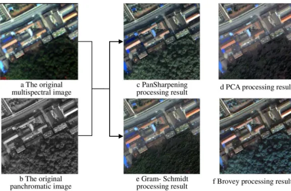
Information Extraction of High Resolution Remote Sensing Images Based on the Calculation of Optimal Segmentation Parameters.
Texto
Imagem


Documentos relacionados
In the absence of high resolution crystal- lographic information, the three-dimensional structure of connexins can only be guessed, and still unclear are the parameters that de-
The probability of attending school four our group of interest in this region increased by 6.5 percentage points after the expansion of the Bolsa Família program in 2007 and
Classification and extraction of spatial features in urban areas using high- resolution multi-spectral imagery, IEEE Geoscience and Remote Sensing Letters ,
It engages in advance thinking and early politi- cal-strategic planning of possible CSDP responses to crises, incorporating both the civilian and the military
Motivation of investigating the influence of the number of finite elements on the results of sensitivity analysis was finding out whether the selected method depends of the
The International Archives of the Photogrammetry, Remote Sensing and Spatial Information Sciences, Volume XL-1/W5, 2015 International Conference on Sensors & Models in
First phase deals with line segmentation and extraction of zone information, second phase deals with syllable segmentation, third phase addressed the classification of
The International Archives of the Photogrammetry, Remote Sensing and Spatial Information Sciences, Volume XL-7/W3, 2015 36th International Symposium on Remote Sensing of
