170
Abstract
The evolution of cities can be interpreted through graphic elements, as recommended by Marco Pollio Vitruvius (1st century BC), whose forms of expression (plans, elevations and perspectives) are revealed as precious and reliable instruments to read the cities. Establishing mapping elements, they appear as representing cities and in various stages of construction of their urban networks. The iconography is an important element of analysis that allows a careful reading of the “reality” of cities at speci c times. In addition to understanding them as representative of static moments, they allow the current reinterpretation of the urban fabric. Adding new elements may be important in reading the cities, which are considered as dynamic tools for its understanding. Regarding cartography and iconography of various eras, we propose to make a comparative analysis of the historical urban fabric of two cities with deployment capabilities and differentiated urban development (Évora and Setúbal). To achieve our goals, we will read the morphological elements of the Medieval City (forti cation, street, square, medieval blocks; market; singular buildings) and its iconography in order to understand its diachronic evolution between their similarities and differences.
Cartography and iconography as diachronic
analysis tools of the urban fabric:
Évora and Setúbal
Maria Tereno¹, Manuela Tomé², Maria Monteiro³
¹Departamento de Arquitetura, Universidade de Évora, Portugal;²SMPCB, Câmara Municipal de Setúbal, Portugal; ³Divisão de Cultura, Património e Turismo, Câmara Municipal de Évora, Portugal
Keywords: Urban morphology; urban design; squares; Portugal
171
Introduction
The evolution of cities can be interpreted through graphic elements, such as that recommended by Marcus Vitruvius Pollio (1st century bC.) (Maciel, 2006), whose forms of expression were plans, elevations and perspectives, which prove to be precious and reliable instruments for the reading of ci-ties. It is important to establish these elements, which appear as represen-tations of cities, in various stages of construction of their urban fabrics, in documents such as cartography or iconography. These are relevant testi-monies in the analysis and allow a careful reading of the “reality” of cities at different times. In addition to understanding them as representations of a certain period, they allow the current reinterpretation of the urban fa-bric, and should be considered dynamic instruments in the understanding of the reading of the cities. Considering cartography and iconography from several epochs, we will make a comparative analysis of the histori-cal urban fabric of two cities, using differentiated urban implantation and development (Évora and Setúbal). To reach these objectives, we will read and interpret morphological elements of the Medieval City (forti cations, squares, streets, blocks, markets, singular buildings among others) and the-se respective witness documents, to understand the diachronic evolution in their similarities and differences.
Geomorphology in the city’s image
Urban development has similar characteristics, in its genesis, although they derive from identical human needs, and it is veri ed that each ur-ban nucleus presents characteristics inherent of their implementation, in highly differentiated topographies with their own unique geomorphologi-cal characteristics.
The experience of societies in a given territory, with its own speci cities, provides the creation of the various dimensions of the society, such as cultural, economic, functional and symbolic factors, which originate a cognitive process of identity. The combination of this set of factors also undoubtedly determines the creation of structuring elements speci c to each city. These include public spaces, such as squares, streets, blocks, and buildings, such as equipment, unique buildings and civil architecture. Considering the study cases, as to its geomorphological framework, we have the city of Évora in the interior of the country, in the center of the Alentejo’s province, on a mildly shaped hill, and the city of Setúbal on the Atlantic coast, in a bay next to the mouth of the River Sado, surrounded by the mountain range of Arrábida. The distance between these two ci-ties is only 82.25 km (51.10 mi), but the environmental, geographic and morphological conditions determined very different economic and urban developments (Fig. 1) based on an economy related to the products of the land, namely the cereal culture, in the case of Évora and linked to uvial-maritime products and activities, with great relevance for the salt industry, in the case of Setúbal.
Concern about the representation of man-occupied space has existed since ancient times to illustrate, one can consider the set of fragments
172
that represent or map the ancient city of Rome by its contemporary in-habitants. This is a valuable document for the visualization of an ancient Roman city, demonstrating the relevance of cartography for the under-standing of cities, although it is not known cartographic representations of Évora and Setúbal, these were constructed through the reuse of Roman structures or on them, respectively.
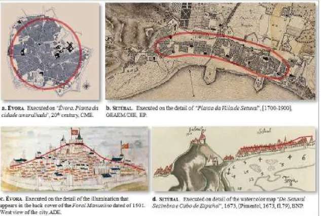
Évora is indicated in the old cartography, since the 18th century as an important urban nucleus appearing on the maps of Portugal and Spain with the corresponding symbolic representation, Setúbal appears in the cartography of nautical character from the 14th century, being marked with the representation corresponding to an important port, from the 15th century, due to the maritime trade routes between the economic powers of that time, namely the commercial trading exchanges from its port. In the most recent cartography, which already allows an analysis of the urban space, we observe different forms of implantation and expansion, whose con guration and morphology are in uenced and determined by the geography and the topography of the place (Fig. 1 - a and b).
In the illustrated iconography (Fig. 1 - c and d) it is possible to verify the differentiation of the pro le designed for the two cities, related to a to-pography that determines and shapes the image as urban implantation grew.
Although conditioned by topography, the cities would assume the di-rectives of Vitruvius (Maciel, 2006, 41) for any city of the Empire. Public equipment, the regularity of the layout and the size of the streets were essential to de ne the urban image.
Évora is a very remote city that still preserves its historical center, surrounded by a set of forti cations whose construction dates back to the end of the Late Middle Ages and which are remarkable in the reading of the urban image of the city (Fig 1- c).
The morphology of the urban fabric of Setúbal was constituted, with an elongated shape, generating with an orientation of urban axes parallel to the coastline (Fig. 1 - b).
Medieval morphological references
Concerns about defending cities have led to the need to reinforce de-fensive systems, strengthen existing structures or build new structures. In these projects, cartographic surveys give rise to more detailed information on the various areas that need intervention. These documents emerge in Evora in modern times. In Setúbal it was felt the need to strategically rein-force the defense during the Spanish government (1580-1640), both for the need to protect the coast, namely this relevant port, as for the Lisbon approach and its integration into its defensive system. The construction of the Fort of S. Filipe, by Philip Terzio, which led to the design of the “Planta da Villa e Porto de Setúbal”, at the end of the the16th century, still not yet detailed at the block level but the main thoroughfares and free public spaces of the medieval city, or be they the squares, are drawn.
ca-173
tions, squares, streets, blocks, markets, and buildings of the cities that in-form their morphologies and images. In the cases under study we highlight the description of Cosme de Médicis’ trip and the respective drawings by Pier Maria Baldi (Fig. 2).
About Évora it is stated that:
“Evora è citta di 4000 fuochi posta sopra un rialto in mezzo d’una campa-gna piana, fértile e coltivata. Ella è senza controvérsia dopo Lisbona, la prima del Regno no ai tempi del Re Don Sebastiano abitazion dei Re, da cui un grandíssimo numero di famiglie titolari ed illustri riconosce lórigine, e vi conserva sino al dí d’oggi, e casa ed avere.” (Faria, 1901, 38).
Being mentioned about Setúbal that:
“Setubal è villa di 2000 fuochi capo di comarca, dove stà il Corregedor, et insieme il famoso Porto di Mare, vantato da molti per la prima fondazione di tutta Spagna, lusingati leggermente dal nome a crederlo edi cato da Tubalcain discendente da Noé. Si distendon le case in forma di mezzo cerchio lungo la spiaggia d’una deliziosa pianura, che riman serrata tra un seno di monti vestito di bosco, e seminati di ville, onde l’aspetto per ogni parte vaghissimo.” (Faria, 1901, 42-43).
In the city of Évora there existed in the High Middle Ages an urban cen-ter of very remote genesis that was surrounded by a perimecen-ter of Roman building wall, here indicated. In Setúbal there are no known defensive structures that dates back to that time and whose existence could have in uenced the present walled medieval form. In Évora a second ring of forti cations was built that covered all the urban expansion consolidated during the 13th -15th centuries. This one began to integrate two concen-tric spaces, connected by the primitive Roman/Goths doors. At the begin-ning of the 16th century the economic and civic center of the city moved from the interior of the primitive space to the outside. The urban fabric was consolidated in the late middle Ages. The buildings grew along the main axes and squares. The location of convents and monasteries were decisi-ve for this densi cation as they were the driving force behind an essential urban economy at that time. In reading the medieval urban image the main churches stand out (Fig. 2 - a)
After the Christian reconquest, religious power in Setúbal was distributed by the churches of Santa Maria and S. Julião, which became the rst two parishes until the 16th century, on creation in 1553, of the parishes of S. Se-bastião1 and Nossa Sra. da Anunciada. In the 14th century, when the ring
of walls was built, these churches already existed, but also the church of Nossa Sra. da Anunciada that was left outside, and the remaining core of space and medieval societies, the Jewish and the Mouraria, urban fabric formed from its center, the Ribeira Square, which in the 16th century mo-ved to the Praça do Sapal. The four parish churches are referred to in the trip of Cosme de Medici (Faria, 1901, 45) and drawn in the urban pro le as reference points in the village, by Pier Maria Baldi (Fig. 2 - b).
The urban space bounded by this forti cation has a structure based on
174
the Square, as an urban, political, administrative, mercantile and civic center, organized from the main street that linked the Porta da Ribeira to the Porta da Vila and ensured communication with the various spaces of the village. From the 16th century, with the great urban changes of D. João III the urban-morphological relations were modi ed with the ope-ning of new connections from new doors built in the forti cation, with the adaptation to the new centrality of urban equipment and the emergen-ce of large areas that became squares. There was a growth beyond the limits of the walled fence that at each moment followed the organizatio-nal parameters that de ned and generated the form, from its center, with the in uence of the coast line in the continuity of the main street, to the West and the East, and with the progressive emergence of squares that contributed to the constitution of new centralities (Fig. 4 - b).
One of the characteristics of the medieval city of Évora is that, despite the diversity of urban typologies, it grew from the primitive walled center to one or more open spaces, close to the forti cation doors, which would become future squares. At the end of the 15th century, the construction of the second walled circuit circumscribed the urban area, encouraging the ow of circulation to the existing doors. The urban space bounded by the medieval wall presents an evolution based on the primitive nucleus, with meshes of different designs structured from the center (Praça de Giraldo) and the paths radiating from the doors of the Roman wall (Alconchel, D. Isabel and de Moura) (Fig. 4 - a).
The need for ample openings along the interior of the forti cations for the circulation of defensive forces and the existence of the yards located at the mentioned doors determined the location of more construction com-pelling to a progressive densi cation in the other areas. One of the hi-ghlights in the medieval city of Évora was the stay of the Portuguese royal family in the city and its consequences.
In Évora the initial urban center centralized the evolution and determined the radial organization of the various types of urban design, whose routes radiate from the main doors.
The medieval core in these cities was composed of multiple social groups, with a mixture of races and religions, Christians, Moors and Jews, autoch-thonous and immigrants whose coexistence was not always peaceful, but was a relevant factor in cultural diversity and social dynamics.
Urban fabric in modern times
After the Restoration of Independence of Portugal, in 1640, the defensive system was reinforced, which included the construction of a modern for-ti cafor-tion that circumscribed the consolidated urban area. From this for-time we have had several studies and cartographies carried out by the various military engineers who worked in the forti cations, which allow us to do a more in-depth reading of the morphological elements that most in uence the cities. Also many copies appeared, of national and foreign authors and some anonymous ones, executed from these cartographic plants (Fig. 3). In Évora the military engineers Charles Lassart, Jean Gillot and
Ni-175
colau de Langres were distinguished among others in the construction of the fortress. From Setúbal, we consider with great relevance the drawings of Jean Gillot, with great de nition of details of the suburb, João Roiz Mou-ro and João Thomas Correa. Such a in Évora Nicolau de Langres, he also worked in Setúbal, having made drawings of this forti cation although with a more simpli ed layout.
These sixteenth-century forti cations continued the trend of the geometry of the space occupied by the former medieval wall, and the former cen-trality of the “urban center” with the convergence of the main guidelines of the city (Fig. 4).
This defensive system, concretized in Évora contributed slightly to the for-mation of a new urban fabric considering that the built bastions were lo-cated very close to the second walled perimeter and the need for ample free space prevented the constitution of more urban fabric. From this for-ti ed base the roads go radially, to Lisboa and Setúbal through the Porta de Alconchel, to Estremoz by the Porta de Avis and, to Beja, through the Porta de Machede. These urban connections resulted from the old ways that evolved into preferred routes of circulation and gave rise to the most convenient openings in the defensive set built over the centuries.
In Setúbal, this forti cation created new boundaries and a new relationship of in uences in urban morphology, both between the various urban spa-ces, and in the relationship between the new urbanity and the rural sur-roundings. The former suburbs were, since then integrated in the urban nucleus and formed the neighborhoods. The urban center continued to perform its functions, communicating with the remaining areas through Rua Direita, which extended and branched across the neighborhoods, in a parallel to the coastline.
Urban expansion beyond the walled limits
The photograph constitutes a fundamental testimony to the knowledge of the cities from the middle of the 19th century. From Setúbal, we highlight the rst known photographs, which contribute to the understanding of its urban and architectural history, by Anthero Seabra and Francisco Rocchi-ni. For Évora we must refer José Pedro Passaporte.
At the end of the 19th century and the 20th century new urban dynamics emerged in uenced by European movements, namely, in the reforms of Paris, which came to change the parameters of the medieval city. With these urban changes of cities would result in an environmental quality that went beyond the limits of the “historic city”, and begin a new cycle corre-sponding to an economic phase based on industry. The adaptation of the cities to the new realities began with the implementation of equipment, infrastructure, public tours, the creation of new public spaces and the or-ganization and regulation of buildings.
In Évora, regarding to cartographed elements, mention should be made of the contribution of Manuel Joaquim de Mattos, at the beginning of the 20th century, and in the middle of the same century, that of the urbanist architect Étienne de Gröer.
176
It dates from the beginning of the 19th century, the plants of Setúbal with a lot of detail of the occupation, both urban and rural, whose plants were carried out by Maximiano José da Serra and later, at the beginning of the 20th century, by Luís Lança, constituting fundamental documents for the knowledge of urban evolution through a comparative analysis.
Due to the displacement of the Royal Family to Lisboa, the city of Évora declined at the end of the 16th century until the middle of the 19th cen-tury, there was no signi cant urban and economic development during this period.
In a city where the urban fabric was lled with private property, the spaces formerly occupied by religious houses provided key areas for urban rege-neration and location of public services. The construction of the railroad provided the urban evolution of speci c areas making the connection between the station and the walled space. In 1945, with the Estado Novo political system, Étienne de Gröer recommended interventions in the ur-ban fabric with an urur-ban plan, proposing the constitution of new streets, opening of new streets and realignment of others, through the sacri ce of existing buildings.
a great expansion, in zoning, in a radial structure from the old city, new streets are indicated towards the already created Av. Luisa Todi, whose relevance is reinforced with the construction of reference buildings, to the detriment of the old city and the current Av. Dr. António Rodrigues Manito which constitutes a great road axis2.
Wide new avenues, with two lanes separated by a central wooded spa-ce3, were created drawn perpendicularly and parallel to the Avenida
Lu-isa Todi, projecting the city to North and to the East with the construction of new neighborhoods.
The urban planning foreground to Évora, by Étiènne de Gröer, an archi-tect town planner for Évora, which began in 1942, proposed different kinds of interventions for different socio-urban scenarios4. Outside of the
whole walled space, Gröer proposed to construct a new urban zone with characteristics of a “garden city” that surrounds the city’s limited ancient nucleus at that time, thus creating a “lung” (Brito and Camarinhas, 2007) that would allow a better environmental quality. The urban space de ned by the successive urbanization plans was structured through the construc-tion of a set of roads, some radial, and some circular, which allowed the interconnection of the various districts dispersed by the surrounding area to the historical center. It should be noted that part of this road structure has not yet been fully implemented for various reasons.
2 This plan was not fully implemented.
3 This typology of streets has been altered. Currently, it exists only on Avenida 22 de Dezem-bro.
4 The foreground by Étiènne de Gröer was based on a new type of urban planning resulting from the IV International Congress of Modern Architecture, from which emerged the new criteria that served as basis to modern urbanism through the Athens Charter of 1933. Of the foreground, there are still in ownership of CME, four plants referring to: “Plan des zones schema des grandes voies” dated 1942; “Anteplane” dated 1945; Two undated pieces: one referenced as “Planta das Zonas” and one last one as “Planta de Apresentação”.
177
The constitution of circulation axes, inside the walled space, along with the constructive reinforcement along its paths would, according to Gröer, create an urban image more intense and adapted to the demands of the new times. At the level of housing typology, the State promoted social housing projects built at a height, contrary to the initial spirit of the 40’s of 20th century. In the interstitial spaces between the walled zone and the new urban perimeter surrounding the walls were foreseen for residents’ use in both Spaces, equipment zones, at key points. These spaces would always be located next to structural axes, near the main doors of the wal-led enclosure located either inside or immediately in the surrounding area also invariably possess parking areas that would complement them.
Conclusion
The development of these cities took place during the same moments of history, through the intervention of the populations that in uenced the shape of the urban space. However, their respective urban genres based on geo-environmental in uence persisted and differentiated these cities. Despite their idiosyncrasies the vestiges that subsisted are different. We can con rm that these characteristics have been maintained throughout the history, through the reading of the cartographic and iconographic documents that accompany it.
This can be seen in the Roman in uence that de ned the still-existing grid pattern in the initial walled nucleus of Évora. This Roman organizational structure was changed in medieval times, and from the 16th century onwards, having maintained the urban occupation bounded by the walls until the expansion in the 20th century. In the 19th century, the city began its adaptation to the car, with the extension of existing roads and the con-sequent tearing of the walls. A road ring was created from which the new roadways began, in continuity of the previous structure of the city that continued to play a dominant role, with its polarizing center in the Praça de Giraldo.
In the case of Setúbal, the location and its geomorphology ensured the conditions of defense, sustainability and development of the urban fabric that was being formed and designed, under the orientation of roadways parallel to the coastline and the progressive emergence of Squares, taking an elongated shape. It began to change his morphological organization in the 16th century, having maintained the medieval layout and the ur-ban consolidation limited by the 16th century forti cation concerning the 17th century until the end of the 19th century, at which time the new lines of urban intervention began and the breakup of this structure was veri ed for the establishment of points of connection to new areas of expansion and especially in the following century with the urban areas arisen.
In the two cities, Setúbal and Évora, we veri ed the existence of an urban morphology with different designs depending on its origin, its relationship with the city, its urban center and the technologies and urban trends that are part of its diachronic history.
178
References
Brito, V., & Camarinhas, C. T. (2007) ´Elementos para o estudo do plano de urbanização da cidade de Lisboa´ (1938) in: Cadernos do Arquivo Municipal, 9, Lisboa, CML, 165-190. Faria, A. d. (1901) Portugal e Italia: Ensaio de Diccionario Bibliográ co (Vol. 2) (Typo-graphia de Raphael Giusti, Leorne).
Maciel, M. J. (2006) Vitruvio. Tratado de Arquitectura (3ª. 2009 ed.) (IST Press, Lisboa). Magalotti, L., & Baldi, P. M. (1933). Setubal in L. Magalotti, A. S. Rivero, & A. Rivero (Edits.), Viaje de Cosme de Médicis por España y Portugal (1668-1669) (Manuscrito (1668-1669), BNCF, BML ed., pp. 118-123), Sucesores de Rivadeneyra, Madrid.
Monteiro, M. F. (2011) Sistema Monástico-Conventual e Desenvolvimento Urbano da Évora na Baixa Idade Média (Tese de Doutoramento, Documento Policopiado ed.), Uni-versidade de Évora, Évora.
Tomé, M. M. (2014) SETÚBAL: Topologia e Tipologia Arquitectónica (séc. XIV - XIX). Memória e futuro da imagem urbana (Tese de Doutoramento, Documento policopiado ed.), Universidade da Beira Interior, Covilhã.
179
Fig. 1 Drawing and urban image forms of Évora and Setúbal.
180
Fig. 3 Representation of several forti cations: “Lisboa e Cacilhas”; “Torre de Belém”; “Setuval”; “Evora”; “Estremoz”; Map with the “Estrecho de Gibraltar”; “Portalegre”; “Elvas”; “Olivença”; “Ba-dajos”; “Albuquerque”; “Castel Branco” and “Villa Franca”, n.a., n.d., MC / CML. We pointed out the detail corresponding to “Setuval” and “Evora”.
Fig. 4 Plant with the indication of the urban centers (1: Center initial, 2: Center from the 16th cen-tury), the main roads in medieval times and the waist of ramparts of modern times.