Improving the Knowledge on Seismogenic Sources
in Lower Tagus Valley for Seismic Hazard Purposes
J. Carvalho, C. C. Pinto, M. Costa, H. Duarte, & P. Terrinha
Laboratório Nacional de Energia e Geologia, Lisboa
T. Rabeh
National Research Institute of Astronomy and Geophysics, Egypt
J. F. Borges, R. Dias & B. Caldeira
Geophysical Center of Évora and Physics Department, ECT, University of Évora, Portugal
SUMMARY: IDENTIFYING SEISMOGENIC SOURCES
The Lower Tagus Valley, that includes the metropolitan area of Lisbon, has been struck by several earthquakes which produced significant material damage and loss of lives. Their exact location remains unknown. Our goal is to shed some light into the seismogenic sources in the area using seismic reflection and geological data. In areas with no seismic coverage, potential-field data interpretation was carried out. Seismicity was overlaid to the potential seismogenic structures and high-resolution data was acquired in order to confirm which structures have been active into the Quaternary. Three major fault-zones affecting the Neogene were identified: V. F. Xira, Samora-Alcochete and Pinhal Novo. For the first fault, strong evidences suggest it is active. The other two fault-zones and other structures previously unknown can be correlated with several epicentres. Empirical relationships between maximum moment magnitude and fault area indicate that MW > 6.5 earthquakes can be expected for the
larger structures.
Keywords: Lisbon, earthquakes, faults, seismic, potential-field
1. INTRODUCTION
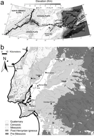
The Lower Tagus Valley is located in central mainland Portugal, where the city of Lisbon is located, about 300 Km from the Eurasia- Africa (Nubia) plate boundary (Fig. 1a). The study area is located between the Gorringe Bank and the Arc of Gibraltar (5ºW) section of the plate boundary, where the plate boundary corresponds to an aproximately E-W trending, dextral transpressive deformation zone associated with an oblique convergence of the plates at approximately 4 mm/yr in the NW-SE direction (DeMetz et al., 1990; 1994; Jimenez-Munt and Negredo, 2003). The Lower Tagus Valley area is densely populated and has been affected by moderate to large earthquakes which are attributed to local sources. This is the case of the 1344, 1531 (M ~ 6.5–7.0) and 1909 (Mw = 6.0) events, which caused important material damages and loss of lives. The exact location of these earthquakes is still unknown though using macroseismic data they have been located in the centre of the Lower Tagus Valley.
The identification of surface ruptures in the study area is a challenging task due to the typical intraplate low slip-rates (< 0.4 mm/year) associated with erosion/sedimentation rates that mask their recognition. On the other hand, identification of earthquake sources based on seismicity data is difficult due to poor epicentre locations previously to the last decade, originated by an insufficient seismic network and a complex geological setting. This difficulties opened way to the use of geophysical methods in order to identify the major seismogenic sources in the study area.
Several authors made use of available seismic reflection data acquired for the oil-industry between 1954 and 1982 that covers partially the study area (Cabral et al., 2003; Vilanova and Fonseca, 2004) to locate and characterize possible seismogenic sources in the area or to study the tectono-stratigraphic evolution of the sedimentary basins of the region (Rasmussen et al., 1998). More recently, this data set
was reprocessed and reinterpreted jointly with available potential-field data for the same purpose (Carvalho et al., 2006; 2008; 2011; Pinto, 2011). Geomorphological data also been used to used to locate Holocene surface ruptures (Besana-Ostman et al., 2012).
Figure 1. a) Location of the study area (indicated by square) and tectonic setting (after Jimenez-Munt et al.,
2003). b) Simplified geological map of the study area (after Oliveira et al., 1992).
In this work, to locate and characterize buried earthquake sources, we make use of recently reprocessed seismic reflection data in the River Tagus south margin reinterpreted with the aid of updated geological information and available gravimetric and magnetic data (Carvalho et al., 2011). A basement map produced by 2.5D magnetic modelling constrained by well, geological and seismic data (Pinto et al., 2010; Carvalho et al., submitted) was also used identify possible deep-rooted seismogenic sources and extend the area covered by seismic reflection data. The derived fault map, complemented with geological outcrop data was overlaid to instrumental seismicity. The major thrust fault zones correlate well with seismicity but other structures that produced important deformation of Neogene sediments show a weak correlation with epicentres. New faults, previously unknown, were also identified, some of which can be associated with several epicentres. Using fault length and area empirical relationships with maximum moment earthquake magnitude, the latter are predicted for the principal derived faults (Table 1).
2. GEOLOGICAL AND TECTONIC SETTING
In the study area outcrop Cenozoic sediments of the Lower Tagus Cenozoic Basin (LTCB), a tectonic depression that surrounds the lower reach of the Tagus River, and the Mesozoic units of the Lusitanian Basin (LB) (Figure 1b). A description of the former basin can be found in Barbosa (1995) and Cabral et al. (2003) while the evolution of the latter basin is described in Wilson et al. (1989), Leinfelder and Wilson (1998), Rasmussen et al. (1998) among others.
The present tectonic stress pattern in the study region, with a NW-SE to WNE-ESE oriented maximum compressive stress has been assessed using various stress indicators (Ribeiro et al., 1996; Borges et al., 2001). The regional tectonic activity is expressed by crustal vertical movements and active faults that were reactivated with different tectonic styles, indicating a compressive regime. Average slip rates are usually <0.3 mm/yr, corresponding to a low to moderate degree of activity (e.g. Cabral, 1995, Carvalho et al., 2006). As a consequence of this tectonic setting, mainland Portugal experiences a moderate seismicity, characterized by small events (M<5.0) and occasional moderate to very large earthquakes, as the well known 1755 ‘Lisbon earthquake’.
Using geological outcrop and geophysical data, several fault zones were mapped in the study area (e.g. Cabral et al., 2003; Carvalho et al., 2006). For some of them, such as the Vila Franca de Xira, Azambuja, Pinhal Novo faults, there is evidence from surface geology of tectonic activity since the Pliocene (Cabral et al., 2003; 2004). Other structures are very probably active into the Quaternary: the Porto Alto fault (Carvalho et al., 2006), which is a probable bifurcation of the Pinhal Novo-Setúbal fault and the Vila Franca de Xira fault (Carvalho et al., 2006; 2009).
The recently proposed OVLS fault zone, which separates a region with of higher seismicity to the west from a zone of lesser activity to the east (Carvalho et al., 2008; 2011), shows three distinct segments with different behavior, in conformity with their various orientations relatively to the maximum compressive stress. The northern segment splays into a series of NNE-SSW oriented, east verging, imbricate thrusts which merge to the west into a major reverse fault that resulted from the tectonic inversion of the former normal fault bordering the Mesozoic Lusitanian Basin in this area, the well known Ota (or Pragança) fault. The central segment corresponds to the approximately 20 km long outcropping Vila Franca de Xira fault, which suffered a maximum degree of inversion. The southern segment, not recognized at the surface, extends for ca. 45 km, crossing Lisbon and the Setúbal Peninsula at depth until approximately Sesimbra (probably continuing offshore) with an N-S trend and distinct geometry.
3. SEISMIC REFLECTION DATA
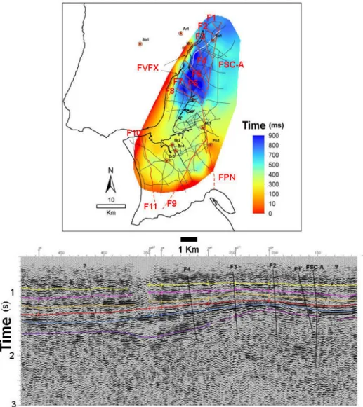
The digital data has been reprocessed by different companies and by one of the authors using a standard processing sequence (preprocessing, deconvolution/spectral whitening, iterations velocity analysis and surface consistent residual statics, integral DMO and conversion to a flat datum) with post-stack or pre-stack time migration. For this work, the interpretation was revised in the southern margin of the Tagus river using the OpenWorks Landmark package. Magnetic and gravimetric data was used to locate salt and igneous structures and picking the basement. Altimetry and revised geological data (LNEG, 2010) were also used. Figure 2 shows the location of the reprocessed and reinterpreted profiles here (Tagus south margin) and by Carvalho et al. (2008, northern margin). Using well logs and vertical seismic profiles a seismic to well tie was achieved (Carvalho et al., 2008; Pinto, 2011) and nine seismic/geological horizons representing the major tectonic and sedimentary phases of the study area were interpreted. The two uppermost were an intra-Neogene horizon, near the top of Upper Miocene and another close to the top of Lower Miocene (intra-Neogene 2). These horizons are important to the identification of seismogenic sources since faults that were active during the Miocene have often been active into the Quaternary (Cabral et al., 2003). Deeper faults are also important since earthquakes occur at several kilometres below the surface. Figure 3 shows an example of an interpreted seismic profile and the time structural map of the intra-Neogene. Almost all faults interpreted for this horizon extend at depth until the basement, as we can observe in the example presented.
Figure 2. Location of reprocessed and reinterpreted seismic reflection profiles. Black lines- seismic profiles;
grey line- coastline.
Figure 3. Top: Structural time map of near top of Upper Miocene, showing wells used in seismic-well tie.
F1 to F11- faults; FVFX- V. F. Xira fault; FSC-A- Samora Correia-Alcochete Fault; FPN- Pinhal Novo-Setúbal fault. Bottom: example of seismic profile (see location in top figure, white line) with interpretation overlaid.
Upper Miocene- yellow line; near top of Lower Miocene- pink line; top of Paleogene- orange line; base of Cenozoic (Middle Jurassic)- red line; Lower Jurassic- blue line; top of Paleozoic- purple line.
4. BASEMENT STRUCTURAL MAP
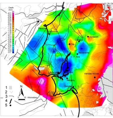
In order complement the seismic interpretation and to cover areas where this information does not exist, a basement map (Palaeozoic and Pre-Cambrian metamorphic and igneous rocks) was obtained from the interpretation of aeromagnetic data. We used data from an aeromagnetic survey (Fairey Surveys) acquired for the oil-industry in 1969 which was reprocessed for this purpose. A more recent IGRF model was extracted, data was reduced to the pole and a grid of profiles was established in order to sample the derived magnetic anomalies appropriately (Pinto et al., 2010; Carvalho et al., submitted). The 2.5D modelling was calibrated using well, seismic and outcrop geological information where available (id). This map was later corrected of the influence of Mesozoic localised volcanic rocks, which do not represent the basement but their strong magnetic signature upraised the derived basement. this correction was carried out using geological, well and seismic data. The faults location was established using the gradient of the depth basement map, 2D Euler solutions and the peaks of the horizontal gradient of the magnetic field (id). The resulting structural depth map is shown in Figure 4 but without fault interpretation (which is presented in Figure 5).
Figure 4. Structural depth map of the top of Pre-Mesozoic rocks, obtained by constrained 2.5D magnetic
modeling, overlaid to geological map (LNEG, 2010).
1- outcrop of pre-Mesozoic rocks or igneous Mesozoic intrusives; 2- geological contours; 3- faults; 4- coastline; 5- localities.
5. HIGH-RESOLUTION GEOPHYSICAL STUDIES AND INSTRUMENTAL SEISMICITY. DISCUSSION
In order to identify the seismogenic structures, relocated seismicity for the period 1970-2000 after Carrilho et al. (2004) and the International Seismological Centre (ISC) catalogue for the period 1918-2010 were overlaid to the derived fault map. The work of Carrilho et al. (2004) contains an average error in the epicentral solutions of 5 km which prevents the association with a specific fault but allows correlation with fault zones above a certain length (Carvalho et al., 2008). The ISC catalogue does not
contain information about epicentre errors but is quite useful to identify seismogenic structures due to the large period covered.
The final map of potential seismogenic faults obtained from seismic reflection, potential-field and geological outcrop data is shown in Figure 5, overlaid to an altimetry map and the ISC catalogue. The first conclusion that we can take from this Figure is that the Montejunto and ArrábidaThrusts (MT and AT, respectively, Figure 5) present the clearest correlation.
Figure 5. Map of potentially seismogenic faults obtained from seismic reflection (continuous red lines),
geological outcrop (id) and potential-field (dash-line) data. The map is superimposed to an altimetry map (in Pinto, 2011) and instrumental seismicity (after ISC).
The V. F. Xira (FVFX, Fig. 3) and Ota (OF, Fig. 5) faults also present a good correlation with seismicity if we take into consideration hypocentral depths and prolong at depth the faults inclination according to seismic reflection data (Carvalho et al., 2008; 2011). This is not visible in Figure's 5 plot of epicentres location by magnitude but it is quite clear in cross-section (id). Two other structures that have also (together with the V. F. Xira and Arrábida faults) produced significant deformation of the Neogene sediments are the Samora Correia-Alcochete (FSC-A, Fig. 3) and the Pinhal Novo-Setúbal (FPN, Fig. 3) faults, both located in the south margin of the Tagus. These two structures can be associated with only a few epicentres.
This may indicate that the deformation is aseismic (caused by the presence of salt, as in the case of Pinhal Novo fault) or that the stress field in recent times has changed and this faults are no longer absorbing most of the deformation. In the seismic data, both faults show an important component of strike-slip kinematics which is less favourable to the present day orientation of maximum compressive stress. The rotation of the Iberian Peninsula in a clockwise direction (Roest and Srivastava, 1991) or the anti-clockwise rotation of the maximum compressive stress during the Cenozoic (e.g. Ribeiro et al., 1996; Taponnier, 1977) seems to indicate that the second hypothesis is the most probable, at least
for the Samora Correia-Alcochete fault, where no important thickness of the Dagorda formation has been identified. The Azambuja fault (AF, Fig. 5), a NNE-SSW thrust with the upraised block to the west which according to geological data presents the best evidences of neotectonic activity (Cabral et al., 2004), also does not correlate with seismicity. Contrarily to the faults with an orientation with a large N-S component, the Ota fault does correlate well with seismicity.
Resuming, structures with a SW-NE (V. F. Xira, Montejunto, F12, F13 and F9 faults) to WSW-ENE (Arrábida thrust) trend show a good correlation with epicentral data, while faults with a more N-S or a NW-SE orientation (Samora Correia-Alcochete, Pinhal Novo-Setúbal faults, faults F1 to F8 in Figure 3) present a weaker correlation with seismicity. The Azambuja fault is the exception to the first group while the Ota fault is an exception to the second group. In the first group also predominate faults with a strong reverse component, while in the second group the strike-slip component dominates. This agrees with the present maximum compressive stress trending WNW-ESE to NW-SE. We can also observe that the basin (Lusitanian) bordering faults have been reactivated while faults inside the Cenozoic basin with the same orientation do not show a similar activity. This situation is often observed in positive basin inversion (e.g. Lowell, 1995).
Another conclusion we can draw from the observation of Figure 5 is that the V. F. Xira, Ota, F10 and F11 faults delineate a boundary of higher seismicity to the west, from a lower seismicity area to the east, as already recognised by Carvalho et al. (2008). This fault system corresponds to, at least in the northern margin of the Tagus, to the border of the Mesozoic Lusitanian basin, located to the west. Therefore, the area of higher seismicity can be explained by a weakened basement originated by the rifting episodes during the Mesozoic.
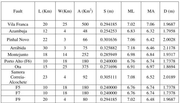
Table 5.1. Maximum expected magnitude for the faults derived in this work using Stirling et al. (2002) empirical
relationships. L- fault length; W- fault wide; A- fault area; S- average value of a single event displacement to the rupture length; ML- maximum moment magnitude using fault length; MA- maximum moment magnitude using fault area; D- average surface displacement.
Fault L (Km) W(Km) A (Km2) S (m) ML MA D (m) Vila Franca 20 25 500 0.294185 7.02 7.06 1.9687 Azambuja 12 4 48 0.254253 6.83 6.32 1.7958 Pinhal Novo 22 3 66 0.301636 7.06 6.42 2.0028 Arrábida 30 3 75 0.325882 7.18 6.46 2.1178 Montejunto 18 14 252 0.285949 6.98 6.84 1.9317 Porto Alto (F6) 10 18 180 0.240000 6.76 6.74 1.7378 Ota 15 25 375 0.271696 6.91 6.97 1.8694 Samora Correia-Alcochete 23 4 92 0.305111 7.08 6.52 2.0189 F5 10 18 180 0.240000 6.76 6.74 1.7378 F7 10 18 180 0.240000 6.76 6.74 1.7378 F9 20 4 80 0.294185 7.02 6.48 1.9687
After the correlation of the potentially seismogenic faults obtained in this work with seismicity, and in order to confirm which of these faults have been active into the Quaternary and characterise this activity, high-resolution geophysical profiles have been acquired over some of the more important structures in a regional context. P-wave seismic reflection and electrical data were first used to image possible shallow faults under the alluvium at the V. F. Xira and Porto Alto (fault F6, Figure 3). The lack of resolution to image a small-throw fault (< 2m) in unconsolidated sediments led us to revisit both sites in order to acquire S-wave seismic reflection (Carvalho et al., 2009) and GPR data. The
results strongly suggest that the V. F. Xira fault affects the entire column of Holocene sediments until a few meters of the surface. At Porto Alto, shear-wave seismic reflection data indicates that a fault segment is present below 20m depth (the alluvium column is about 50m thick here) and GPR data confirms that no fault is present in the shallowest 15m (Carvalho et al., 2012). However, the GPR profile is 30m longer then the shear-wave profile and suggests the presence of shallower fault segments at the end and beyond the seismic profile. Further studies, including trench opening at V. F. Xira site are being planned to characterise the faults activity. Also, more geophysical studies are being planned for other structures, like faults F12 and F13 of Figure 5, which were derived with potential-field methods and need to be confirmed by seismic and geological studies.
In Table 1 we show maximum expected earthquake magnitude and several fault parameters (width, length, area, average single event displacement, average surface displacement) for the faults with a higher probability of having been active into the Quaternary according to geological studies, seismicity analysis and the high-resolution geophysical studies. The identification of these faults is carried out in Figures 3 and 5. The empirical relations of Stirling et al. (2002) were used. The table contains only faults with a length equal or greater then 10Km. The faults width was estimated using hypocentrals depths for the faults with a good correlation with seismicity, or using seismic reflection data. In the latter case the faults wide is very probably underestimated, since the faults are difficult to image inside the basement with seismic reflection data.
The first conclusion we can draw from Table 1 is that we get very similar estimates for the maximum magnitude except for the faults whose width was estimated using seismic reflection data. In this case the maximum magnitude is underestimated if we use fault area to derive it. Average single event displacements and surface ruptures are compatible with values obtained in similar tectonic and geological environments (e.g. Ferry et al., 2005). The more important conclusion however is that several faults in the study area are capable of producing moderate to large earthquakes. Recurrence rates of these structures are difficult to estimate, but values between 900 and 5000 years for magnitudes over 6 have been proposed (e.g. Carvalho et al., 2006). The existence of several active faults and the possible clustering of earthquakes, together with their proximity to the metropolitan area of Lisbon and surrounding cities justifies the continuation of geological and geophysical studies to better characterise the identified faults seismic activity.
5. CONCLUSIONS
Using seismic reflection, potential-field, geological outcrop and seismicity data in a single interpretation platform we were able to identify several potentially and active seismogenic structures in the study area. Some of these structures were previously unknown. Using empirical relationships we estimated maximum expected moment magnitude earthquakes from the faults parameters. Earthquakes with magnitudes above 6 can be generated by the identified faults. Taking into consideration the crude estimates of recurrence periods for moderate to large earthquakes in the area, the number of active faults and their proximity to highly populated areas, the region has a high seismic hazard and risk. Further studies including acquisition of high-resolution geophysical data and trenching are being planned for a better assessment of the seismic hazard and risk of the region.
ACKNOWLEDGEMENT
The Portuguese Foundation for Science and Technology is greatly appreciated for financing Projects ATESTA (PTDC-CTE/GIX 099548/2008) and NEFITAG (PTDC-CTE/GIX 099548/2008). The Department for Oil Prospection and Research of the National Directorate for Energy and Geology is strongly acknowledged for providing seismic reflection, well and aeromagnetic data. Our thanks to L. Torres for supplying gravimetric data.
REFERENCES
do Baixo Tejo, Relações com o eustatismo e a tectónica. PhD thesis, University of Lisbon.
Besana-Ostman, G. M., S. P. Vilanova, E. S. Nemser, A. Falcão-Flor. S. Heleno, H. Ferreira, and Fonseca, J. D. (2012). Large Holocene Earthquakes in the Lower tagus Valley Fault Zone, Central Portugal. Seismological
Research Letters 83, 67-76.
Borges, J. F., Fitas, A. J. S., Bezzeghoud, M., Teves-Costa, P. (2001). Seismotectonics of Portugal and its adjacent Atlantic area. Tectonophysics 337, 373-387.
Cabral, J., Ribeiro P., Figueiredo P., Pimentel N. and Martins A. (2004). The Azambuja fault: An active structure located in an intraplate basin with significant seismicity (Lower Tagus Valley, Portugal). Journal of
Seismology 8, 347–362.
Cabral, J., Moniz, C., Ribeiro, P., Terrinha, P. and Matias, L. (2003). Analysis of seismic reflection data as a tool for the seismotectonic assessment of a low activity intraplate basin- the Lower Tagus Valley (Portugal), Journal of Seismology 7, 431-447.
Cabral, J. (1995). Neotectónica em Portugal Continental. Memórias do Instituto Geológico e Mineiro 31, Portugal.
Carrilho, F., Nunes, J.C., Pena, J. and Senos, M.L. (2004). Catálogo Sísmico de Portugal Continental e Região Adjacente para o período 1970-2000. Instituto de Meteorologia, ISBN 972-9083-12-6.
Carvalho, J., Rabeh, T., Dias, Rui, Dias, Ruben, Pinto, C., Oliveira, T., Cunha, T. and Borges, J. (submitted). A Basement Map of the Lower Tagus Valley Area Using Potential Field, Well, Seismic and Geological Data. Tectonophysics, TECTO8116.
Carvalho, J., Rabeh, T., Bielik, M., Szlaiova, E., Torres, L., Silva, M., Carrilho, F., Matias, L. and Miranda, J. M. (2011). Geophysical study of the Ota- V.F. Xira-Lisboa-Sesimbra fault zone and of the Lower Tagus Cenozoic basin. Journal of Geophysics and Engineering 8, 395-411.
Carvalho, J., Ghose, R, Pinto, C. and Borges, J. (2009). Characterization of a Concealed Fault Zone Using P and S-wave Seismic Reflection Data. EAGE Near Surface 2009/15Th Meeting of Environmental and
Engineering Geophysics. A14.
Carvalho, J., Taha, R., Cabral, J., Carrilho, F. and Miranda, M., (2008). Geophysical characterization of the Ota-Vila Franca de Xira-Lisbon-Sesimbra fault zone, Portugal. Geophysical Journal International 174, 567-584. Carvalho, J., Cabral, J., Gonçalves, R., Torres, L., Mendes-Victor, L. (2006). Geophysical Methods Applied to
Fault Characterization and Earthquake Potential Assessment in the Lower Tagus Valley, Portugal. Tectonophysics 418, 277-297.
DeMets, C., Gordon, R., Argus, D. and Stein, S. (1990). Current Plate Motions. Geophys. J. Int. 101, 425–478. DeMets, C., Gordon, R. G., Argus, D. F. and Stein, S. (1994). Effect of recent revisions to the geomagnetic
reversal time scale on estimates of current plate motions. Geophyis. Res. Lett. 21, 2191-2194.
Ferry, M., Meghraoui, M., Delouis, B. and Giardini, D. (2005). Evidence for Holocene paleoseismicity along the Basel-Rheinach active normal fault (Swizerland): a seismic source for the 1356 earthquake in the Upper Rhine graben. Geophysical Journal International 160 (1), 554-572.
Jimenez-Munt, I. and Negredo, A.M. (2003). Neotectonic modelling of the western part of the Africa-Eurasia plate boundary: from the Mid-Atlantic ridge to Algeria. Earth and Planetary Science Letters 205, 257-271. Leinfelder, R.R., and Wilson, R. C. L. (1998). Third-order sequences in an Upper Jurassic Rift-related
second-order sequence, Central Lusitanian Basin, Portugal, in Mesozoic and Cenozoic Sequence Stratigraphy of European Basins, edited by. P. C. Graciansky, Hardenbol, J., Jacquin, T., Vail, P.R., SEPM Special Publication, 60, 507–525.
LNEG (2010). Geological Map of Portugal scale 1: 1 000 000. Laboratório Nacional de Energia e Geologia. Lowell, J. D. (1995). Mechanics of basin inversion from world wide examples. in Basin Inversion, eds.
Buchanan, J. G. and Buchanan, P. G., Geological Society Special Publication 18, Oxford, 39-57. Oliveira, T., coord (1992). Geological Map of Portugal, 1: 500. 000 scale. Serviços Geológicos de Portugal. Pinto, C. C. (2011). Identification of Potentially Seismogenic Structures in the Lower Tagus Valley Region.
M.S. thesis, University of Évora.
Pinto, C. C., J. Carvalho, M. Costa, T. Rabeh, P. Terrinha, H. Duarte, J. Borges, B. Caldeira and J. Cabral, J. (2010). Seismogenic Sources in the Lower Tagus Area Using Geophysical Data. 72nd EAGE Conference & Exhibition incorporating SPE EUROPEC 2010. .
Rasmussen, Erik S., Lomholt, S., Anderson, C. and Vejbaek, O. V. (1998). Aspects of the structural evolution of the Lusitanian Basin in Portugal and the shelf and slope area offshore Portugal. Tectonophysics 300, 199-225.
Ribeiro, A., Cabral, J., Baptista, R. and Matias, L. (1996). Stress pattern in Portugal mainland and the adjacent Atlantic region, West Ibéria. Tectonics 15, 641-659.
Roest, W. R. and Srivastava, S. P (1991). Kinematics of the plate boundaries between Eurasia, Iberia, and Africa in the North Atlantic from the Late Cretaceous to the present. Geology 19(6), 613-616.
Stirling, D., Rhoades, D. and Berryman, K. (2002). Comparison of earthquake scaling relations derived from data of the instrumental and preinstrumental era. Bull. Seis. Soc. Am. 92, 812–830.
Tapponier, P. (1977). Evolution tectonique du systéme alpin em Méditrrané: poinçonnement et écrasement rigide-plastique. Bulletin de la Société Geologique de France 29, 437-460.
Vilanova, S. P., Fonseca, J. F. B. D. (2004). Seismic hazard impact of the Lower Tagus Valley Fault Zone (SW Iberia). Journal of Seismology 8, 331-345.
Westerhausen, H. (1956). Report on Reflection and Refraction Seismic Investigations carried out in South Tejo Basin for Companhia dos Petróleos de Portugal and Mobil Exploration Company Lisboa (Portugal). Prakla, 20 p.
Wilson, R. C. L., Hiscott, R. N., Willis, M. G. & Gradstein, F. M. (1989). The Lusitanian Basin of west central Portugal: Mesozoic and Tertiary tectonics, stratigraphy and subsidence history. In: A. J. Tankard and H. Balkwill (Eds.), Extensional tectonics and stratigraphy of the North Atlantic Margins, American Association Petroleum Geologists Memoir, 46, 341-361.