ARKADIUSZ TYSZKO*, TOMASZ TEMLIN, STANISŁAW OSZCZAK University of Warmia and Mazury in Olsztyn
Chair of Satellite Geodesy and Navigation Heweliusza 5, 10-957 Olsztyn, Poland
*Corresponding author. E-mail: [email protected]
GNSS SYSTEMS IN VEHICLE FLEET MANAGEMENT
Summary. GNSS (Global Navigation Satellite System) in connection with other technologies, such as mobile telephone GSM will improve management of chains of orders and fleet management in all types of transport. The paper describes existing navigation satellite systems (NAVSTAR GPS, GLONASS, EGNOS). It also presents advantages and barriers of using GNSS in transportation systems.
GNSS W SYSTEMACH ZARZĄDZANIA FLOTĄ POJAZDÓW
Streszczenie. GNSS (Globalny Satelitarny System Nawigacyjny) w połączeniu z innymi technologiami, takimi jak telefonia komórkowa GSM, będzie wpływał na usprawnienie zarządzania łańcuchem zamówień oraz zarządzania flotą we wszystkich typach transportu. Referat opisuje istniejące nawigacyjne systemy satelitarne (NAVSTAR GPS, GLONASS, EGNOS). Zostały równieŜ przedstawione zalety oraz przeszkody wykorzystywania GNSS w systemach transportowych.
1.INTRODUCTION
One of the basic functioning principles of modern enterprise (not only transport enterprise) is its own vehicle fleet. Using new technologies and Global Navigation Satellite Systems (GNSS) the effective vehicle fleet management systems are built. These solutions allow to use it extensively to decrease operational and maintenance costs.
2.USING GNSS IN VEHICLE FLEET MANAGEMENT
Fleet management has got a lot of different applications and their common characteristic is gathering information connected with localization and vehicle movement parameters. Data gathering is made by management centre (logistic) in order to use this information for movement organization in real time and for further, different analysis. The first solution consisted in reading information concerning for example route course, time of journey, tanking up, etc. after coming back to base. Newer solutions brings possibility of data transferring in real time from built-up measurement systems installed on vehicles.
The vehicle fleet management systems gives a lot of advantages. The most basic advantages are the following:
− shortening realization time of order;
− increase of punctuality of provided services;
− improvement of people’s safety, safety of charge and vehicles (alarm connections); − limitation and even elimination of abuse committed by drivers;
− possibility of entering gathered information directly to computer systems of enterprise in order to carry out further analysis. Vehicle fleet management can be done by external enterprises or by appointed department. Smaller enterprises choose the first solution considering a matter only on their merits. Big transport enterprises having their own logistic centers that function continuously manage the fleet on their own.
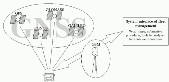
Fig. 1.GNSS technologies in vehicle fleet management systems.
Rys. 1.Technologie GNSS w systemach zarządzania flotą pojazdów.
Typical examples of using vehicle fleet management systems are as follows: − emergency services (ambulance, police, fire brigade, municipal guard); − distributive enterprises;
− transport of goods (short-and long-distance); − city communication;
− municipal services;
− transport of money and valuable goods.
The most important tool used in fleet management system is US system Navigation Satellite Timing and Ranging Global Positioning System called in abbreviation NAVSTAR GPS or simply GPS (Global Positioning System). This system consists of three linked segments: space, ground- control and user’s.
The space segment is associated with recent constellation of 30 active satellites placed on circum-earth orbits at the height of about 20 180 km. Each of 6 orbits, in which satellites move, is inclined to equator plane at an angle of about 55°. The dihedral angle between orbits is about 60°. Four or five satellites move on each orbit. Even satellite positioning on constant circular orbits guarantees access to signals at least from four of them in every moment of observation and from every place on the Earth surface.
The user segment consists of different military and civil satellite receivers designed to receive, decode and process signals sent from satellites. These are receivers that functioning on their own or they are integrated with other systems. On account of their use, GPS receivers differ in characteristics concerning requirements of environment in which they must work, possibilities of dynamics objects positioning, measure must resist to static, etc. Accuracy of GPS system for autonomic horizontal position is about 10 meters. Receivers receiving corrections from supporting satellite systems or ground reference stations can define their position with accuracy of 1-3 meters. One should underline that the accuracy of position depends on many parameters such as: number of satellites, satellite geometry, multipath effect, status of ionosphere and, can vary.
Russian satellite system GLONASS (Globalnaja Nawigacjonnaja Sputikowa Sistema) is a functional equivalent of above mentioned US GPS system. Now, constellation of 12 active satellites (targetly 24 satellites) are placed on three circular orbits. The average height of satellite is 19 100 km. The inclination angle of the orbit to the equator plane is 64,8°.
The main tasks of the segment of ground control as are follows: Calculating and updating of ephemeredes of all satellites,
Synchronizing of atomics clocks installed on satellites with time scale of the system.
We can characterize the user’s segment analogically to users of GPS system, but error in defining position is larger due to the smaller number of operational satellites.
EGNOS (European Geostationary Navigation Overlay Service) is a satellite system, functioning in Europe, supporting air, sea and land users of two military systems: US GPS and the Russian GLONASS (in the future). It is the first stage in creating European satellite system Galileo. System EGNOS does not have yet in 2007 the status of full operation. It consists of four segments: space, ground, user’s and supporting devices.
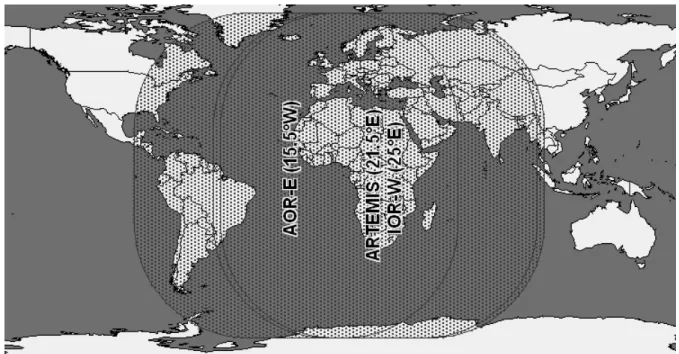
Three geostationary satellites which retransmit information coming from ground stations NLES to users constitute space segment (Navigation Land Earth Station). Choice of arrangement of satellites is that European user could in every moment receive signal from at least two of them. Positions (longitude) of geo-satellites are as follows: AOR-E (Atlantic Ocean Region – East) – 15,5°W; IOR-W (Indian Ocean Region – West) – 25°E; ARTEMIS (Advanced Relay Technology Mission) – 21,5°E. Geostationary satellites transmit the differential range and ionospheric corrections to the satellites, which give a chance to increase the accuracy and reliability of horizontal position up to 1 – 2 meters. The geo-satellites transmits also signal similar to the GPS L1 frequency.
Fig. 2.Space segment of the EGNOS system.
The control segment of EGNOS consists of the following components: − four main control stations MCC (Mission Control Center);
− 34 observation-measurement stations RIMS (Ranging and Integrity Monitoring Stations), - one of them is situated in Warsaw;
− The above mentioned stations NLES transmitting data to satellites.
User’s segment is constituted by receivers with option of receiving EGNOS signal, transmitted from geostationary satellites, where a user can observe minimum two. These receivers can process information sent from space segment and show user’s position with the accuracy of 1 – 2 meters.
3.RECORDING OF ROAD ACCIDENTS WITH DGPS/GPRS TECHNOLOGY
Safety of traffic concerns directly every man. Being everyday active participants of traffic we are directly interested in high level of safety on roads. Results of tests carried out for many years show that Poland is a country which has a lot to do in relation with safety of traffic. We are a country with a great number of dead casualties of road accidents. New systems of management of traffic safety are tools bringing possibility to improve safety on roads. The fundamental task of these systems is the realization of reduction of number and effect of road accidents. Fast technological progress in data transferring, data management and diffusion of Global Satellite Navigation Systems give possibility of simplification and modernization of procedures used now. Entering information to system concerning localization (event position), with precision required by road engineers, will allow to analyze causes of events and to undertake suitable actions supporting process of taking decisions related to project.
4.PERSPECTIVES OF DEVELOPMENT OF GNSS USE IN VEHICLE FLEET MANAGEMENT
Development of GNSS (Global Navigation Satellite System) will assure possibility of improvements related to goods logistics. Making possible accurate and continuous control of packages, containers or palettes, GNSS in connection with other technologies, such as mobile telephone GSM (Global System for Mobile Communications), will improve management of chains of orders and fleet management in all types of transport. Advantages will be accessibility in towns as well as in case of long-distance international transport. What is more, in context of modal transport, you can increase safety thanks to electronic seals and new localization devices.
Constructive solutions will lead to connection of navigation systems and fleet management systems in order to provide information by one board device to manager and person who manages a vehicle base.The near future will bring effects directed to integration of Digital Tachograph Systems (DTS), Global Navigation Satellite Systems (GNSS) and also new technologies of data transferring (GPRS, UMTS). Integrated systems will improve many factors having important effect on improving safety and effectiveness of road transport.
4.1.MODERNIZATION OF GPS SYSTEM
For civil purposes a number of satellite, from which signal reception is possible is often insufficient, which constitute limitation of GPS system capabilities. However, high cost related to placing satellite in orbit excludes serious considerations about satellite GPS constellation increase. Development and diffusion services such as: LAAS, WAAS and DGPS distributing corrections to measurements registered by receivers GPS will increase accuracy and credibility of registered information and it will be alternative for enlargement of number of satellites.
power with about 6dB higher than power of signal C-A sent in L1 band. These solutions aim at decreasing error of measured pseudo-distance, which leads to increase precision of determined position.
4.2.FULL OPERATIONAL STATUS OF SYSTEM EGNOS
System EGNOS will guarantee three types of free services for all users:
− increase in user’s safety and system integrity (in 6 seconds system EGNOS should inform user about any incorrect functioning of system GPS),
− increase in accuracy of measured position by taking differential corrections into account, − increase of the range of GPS system (geostationary satellites of EGNOS system will be used as
additional satellites of GPS system).
By making the EGNOS system fully operational it will bring a better increase of accuracy and integrity of user position determination.
Basic architecture enabling successful realization of objectives will be constituted fully by operational Global Systems of Satellite Navigation (GNSS). After 2012 European operational system Galileo will be ready for use. Five types of services offered by this system will develop considerably the possibilities of vehicle fleet management. The first type of service OAS (Open Access Service) will be associated with basic capabilities of service SPS (Standard Positioning Service) offered by the system GPS. Access to this service will be free. Services OAS and additionally signals confirming integrity and credibility of data will constitute service SoL (Safety of Life). The possibility of third type of service –CS (Commercial Service) will constitute the base of advanced services, being enlargement of basic tasks of fleet management. To use, controlled by national administration service PRS (Public Regulated Service) it will be accessible and it will have guaranteed continuity of action. The last service SaR (Search and Rescue) will facilitate enlargement of existing fleet management systems in relation with module of searching and life rescue.
4.3. ADVANTAGES OF USING GNSS IN TRANSPORT OF VEHICLES IN A POLISH CONTEXT
Global systems of satellite navigation GNSS can be considered as a basic architecture, for development of new applications. As we estimate, it will be applied in most cases in transport.
4.4.BARRIERS OF USING GNSS SYSTEMS IN VEHICLE FLEET MANAGEMENT
Although there are many advantages resulted from vehicle fleet management system, there are barriers concerning its implementation in an enterprise. These barriers concern limited personal skill or lack of qualified staff. Every enterprise focuses first of all on its statutory activities and not always it has possibility to employ staff in system management. Fleet service made by external enterprise (outcoursing) gives the rise to fears in relation with transferring data to third enterprises.
Additional barrier concerning vehicle monitoring can be done by legal aspect connected with the consent of people to their monitoring.A device which register vehicle position and movement parameters is often uncomfortable for the operator/driver of this vehicle. You can observe very high failure of installed devices.
You can solve this problem by trainings prepared on a large scale designed for users of fleet management systems using GNSS technologies.
Literature
1. Boa-Yen Tsui J.: Fundamentals of Global Positioning System Receivers: A Software Approach. John Wiley & Sons, Inc. 2000.
2. Ciecko A., Oszczak S.: Estimation of Accuracy of Satellite Dynamic Positioning. The 11th IAIN World Congress, Berlin, Germany, 21 – 24 October 2003, CD ROM Proceedings.
3. French T. G.: Understanding the GPS. An Introduction to the Global Positioning System. What It Is and How It Works. GeoResearch, Inc. 1996.
4. Misra P., Enge P.: Global Positioning System, Signals Measurements, and Performance. Ganga-Jamuna Press, 2006.
5. Mohinder S. G., Lawrence R. W., Angus P. A.: Global Positioning System, Internal Navigation, and Integration. John Wiley & Sons, Inc. 2001.
6. Naumienko B.: EXGALILEO Extensions of Galileo System based on European Digital Tachograph. ATVN-EU-GP, Brokerage Event, 20 October 2006, Warsaw, Poland.