Land Cover Classification from Multispectral Data Using Computational Intelligence Tools: A Comparative Study
Texto
Imagem
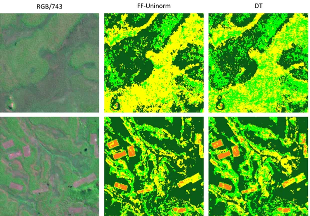
![Figure 3. (a) Land cover ground-truth classification as published by Temudo et al. [2]; (b) Fuzzy-Fusion (FF)-Uninorm classification; (c) FF-Uninorm classification after applying a mean filtering.](https://thumb-eu.123doks.com/thumbv2/123dok_br/16697054.743862/8.892.125.767.288.510/classification-published-uninorm-classification-uninorm-classification-applying-filtering.webp)
Documentos relacionados
In the Machadinho d’Oeste study area, the 2001 Landsat ETM image was used to conduct land use/ cover classification, consisting of 12
Using the Corine Land Cover database as reference and continental Portugal as the study area, we establish a possible correspondence between both classification
Several authors have already focused on the problem of automatic land cover mapping from multitemporal and multispectral satellite images of medium spatial resolution
This study is concerned with identifying change in land use and land cover types in East Timor between 1972 and 2011, using satellite images from Landsat MSS, TM and ETM+
There are many suitable algorithms and techniques proposed in the literature to deal with the two levels of image fusion processes, such as: multi-resolution analysis,
The comparison of classification in artificial and fuzzy neural networks technique has been conducted to separate classes of forest from non-forest using SPOT satellite
Se os computadores e a internet são, hoje em dia, considerados ferramentas fundamentais para o estudo, o desempenho de uma profissão e mesmo para o exercício
L’idée de consacrer une séance à la mise en scène et à la mise en exposition de la chasse dans les cultures extra-européennes est née d’un double constat : d’une part, les
