Vol.46, n. 3 : pp. 307-314, June 2003
ISSN 1516-8913 Printed in Brazil
BRAZILIAN ARCHIVES OF
BIOLOGY AND TECHNOLOGY
A N I N T E R N A T I O N A L J O U R N A L
Use of Cesium
-137Methodology in the Evaluation of
Superficial Erosive Processes
Avacir Casanova Andrello
1∗, Maria de Fátima Guimarães
2, Carlos Roberto Appoloni
1and
Virgílio Franco do Nascimento Filho
31
Departamento de Psicologia; CCE; Universidade Estadual de Londrina; C. P. 6001; 86.051-990; Londrina - PR - Brazil. 2 Departamento de Agronomia; CCA; Universidade Estadual de Londrina; C. P. 6001; 86.051-990; Londrina - PR - Brazil. 3 Laboratório de Instrumentação Nuclear; CENA/USP; C. P. 96; 13400-970; Piracicaba - SP - Brazil
ABSTRACT
Superficial erosion is one of the main soil degradation agents and erosion rates estimations for different edaphicclimate conditions for the conventional models, as USLE and RUSLE, are expensive and time-consuming. The use of cesium-137 antrophogenic radionuclide is a new methodology that has been much studied and its application in the erosion soil evaluation has grown in countries as USA, UK, Australia and others. A brief narration of this methodology is being presented, as the development of the equations utilized for the erosion rates quantification through the cesium-137 measurements. Two watersheds studied in Brazil have shown that the cesium
-137
methodology was practicable and coherent with the survey in field for applications in erosion studies.
Key words: Superficial erosion, erosion rates, cesium-137 methodology
∗ Author for correspondence
INTRODUCTION
Superficial erosion is one of the main soil degradation agents. However, erosion and sedimentation rates estimations associated to different soil cultivation procedures and uses are scarce, and the conventional methods used in determining these estimations are usually expensive and time consuming. Erosion and sedimentation rates estimations using the cesium-137 method have been reported by several researchers, especially for the Northern Hemisphere.
The atomic age started with the first nuclear weapon detonation in July 1945. The arms race that followed, contributed to the environment contamination through radioactive fallout. Nuclear
(> 1 megaton), great part of the resulting cloud penetrates the stratosphere, making the fission fragments lasting longer in the atmosphere. The passage of the fragments to the troposphere causes the so-called global fallout. The time between the injection of fission products in the stratosphere and the subsequent fallout varies from 5 or 6 months to 5 years, depending on the latitude, altitude and seasonal injection period. The slow diffusion of the fission fragments in the stratosphere due to slow winds causes greater fallout in the hemisphere where the explosion occurred. Since the most of the nuclear tests were held in the Northern Hemisphere, the fallout distribution shows a distinct and well-defined peak in this hemisphere and a smaller and less defined peak for the Southern Hemisphere, as seen in Figure 1.
Figure 1 - Gamma spectrum of soil samples of the Northern (a) and Southern (b) Hemispheres. Adapted from Guimarães (1988).
The amount of fallout depends on the meteorological conditions during the rain period, the amount of radioactive fragments in the atmosphere and the altitude in which it occurs.
Although the cesium-137 fallout is related to precipitation, this relation is not constant, varying in space and time. The global scale fallout began in 1952, after the first tests with thermo-nuclear weapons which had enough power to inject fission fragments in the atmosphere. The number of detonations grew quickly, reaching its peak between 1957 and 1958, when they were suspended. Reinitiated in September 1961, the detonations reached their maximum peak in 1962 and 1963. In August 1963, the Nuclear Test Ban Treaty was signed, restricting tests to underground detonations. Most of the fallout occurred in the period from 1956 to 1964, and the cesium-137 deposition was relatively small from 1970 onward. Figure 2 shows the cesium-137 global deposition and includes the peak related to the Chernobyl accident in 1987, which contributed to local fallout.
Cesium-137: Cesium is a rare alkaline metal that forms strong bases. Its salts are usually soluble in water. It is the most electropositive and reactive of all metals, oxidizing immediately when in contact with the air.
Figure 2 - Spectrum of the cesium-137 global deposition (fallout curve) and of the cesium-137 inventory through the years (inventory curve). Extracted from the http://www.ex.ac.uk/~yszhang/ caesium/csdis.gif.
barium-137 radionuclide, which declines by gamma emission to the stable barium-137, with a lifetime of 2.55 minutes. Gamma ray emitted by the meta-stable barium-137 has a 661.6 keV energy that characterizes the cesium-137 in the study by gamma ray spectrometry. Studies of the cesium-137 properties started with the operation of the first nuclear reactors. Since this radionuclide is produced in large amounts and has a long lifetime, several studies were conducted on the radiological impact of its presence in the environment and its reactions to soil minerals and their incorporation in vegetables (Rogowski and Tamura, 1965, 1970). In the early 1970’s, studies about the movements of soil particles through the redistribution of the cesium-137 deposited by the fallout were initiated, once its distribution in the landscape could reflect the magnitude of the erosion processes (Ritchie et al., 1974).
Behavior of cesium-137 in the soil: Cesium-137 is a monovalent cation with low hydration energy but strongly fixed by clay minerals, which suggests the existence of high selectivity points for these cations. The low hydration energy of the monovalent cations causes dehydration and the collapse of the clay crystalline structure, keeping these monovalent cations between their layers. Clay selectivity is associated with its high charge density and frayed edges, once cations such as the K+ and the Cs+ penetrate the layers and cause them to collapse through electrostatic attraction force. This causes the cations to be trapped or fixed. Studies about the cesium-137 adsorption revealed that most soils could retain cesium-137 when applied in low quantities, as it occurs in the fallout. Repeated extractions with many different chemical agents also indicate that cesium-137 is strongly adsorbed and fixed by soils; however, their movement is restricted by lixiviation and other natural chemical processes. So, its redistribution in the fields can only occur by physical processes (Livens and Loveland, 1988; Livens and Rimmer, 1988).
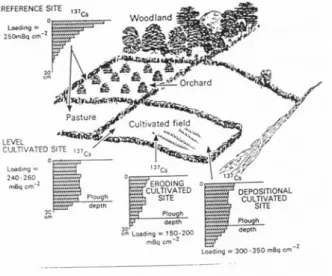
Cesium-137 depth distribution in the profile depends on whether or not the soil has been cultivated after the fallout. In non-cultivated soils cesium-137 concentration decreases exponentially with the depth, whereas in cultivated soils, it shows a uniform distribution until the depth of the plough layer. This distribution is shown in Figure 3.
LITERATURE REVIEW
Cesium-137 is found in association with the clay and the organic matter, soil fractions that are more susceptible to erosion. Cesium-137 is a good tracer for evaluating superficial erosion processes since it is restricted to the soil surface. Taking this fact into consideration, Rogowski and Tamura (1965) decided to study the movement of cesium-137 in the soil under the action of physical agents, which made them establish an empirical relationship between cesium-137 redistribution and soil loss by runoff and erosion.
An important development occurred when Ritchie et al. (1974) showed that there was a relationship between losses by erosion calculated by the USLE (Universal of Soil Loss Equation) by Wischmeier and Smith (1962), with the loss of cesium-137 from the fallout in soils with different kinds of cultivation.
Figure 3 - Profile of cesium-137 distribution in the soil with different kinds of cultivation. Taken from the http://www.ex.ac.uk/~yszhang/caesium/ profile.jpg.
X = 1.6 Y0.68 (1)
where:
X = the percentual loss of the radionuclide, and Y = the total soil loss (ton.ha-1.year-1).
In 1975, Ritchie and McHenry (1975) established a new equation, considering the soil loss as an independent variable:
Y = 0.88 X1.18 (2)
This equation has been used to estimate erosion rates through cesium-137 measurements by several researches (McIntyre et al., 1987, Menzel et al., 1987, Lowrance et al., 1988). Although equation (2) was presented as being statistically significant, it has serious limitations if used as a calibration equation. Firstly, the data used in its elaboration were obtained from a large variety of sources and could be inconsistent. Secondly, the data used to establish the equation referred to soil losses from different periods of time and should not have been combined in the equation derivation.
Other empirical relations developed by Campbell et al. (1986) using 30 erosion parcels from the east of New South Wales, Australia, established a exponential relation between the loss of cesium-137 and the soil loss, as follows:
Y = 3.84 X1.55 (3)
or
Y = 4.54 X1.45 (X< 60%) (4)
Y = 0.04 X2.74 (X> 60%) (5)
where:
Y = the liquid soil loss (kg.ha-1.year-1), and X = the reduction percentage in the total amount of cesium-137 in the soil.
These equations estimated soil loss for a same percentage of cesium-137 loss, one order of lesser magnitude than that of the Ritchie and McHenry equation (1975) due to the different environmental conditions found in Australia, which included smaller entry fallout of cesium-137.
Theoretical Models: The most simple theoretical model used in the development of a calibration
relation applicable to cultivated areas is the proportional model, which establishes a direct proportionality between soil loss and the amount of cesium-137 removed from the soil. Several variants of this calibration equation have been proposed (De Jong et al., 1983, 1986; Martz and De Jong, 1987; Kachyearski, 1987; Vanden Berghe and Gulinck, 1987, Fredericks and Perrens, 1988), but the relation is effectively the same, with the soil loss annual mean being calculated by the equation:
T 100 DBX 10
Y= (6)
where:
Y = the mean annual soil loss (ton.ha-1.year-1), D = the depth of cultivation (m), B = the soil bulk density (kg.m-3), X = the reduction percentage in the total amount of cesium-137, and T = the time period elapsed since 1963 (in years).
Contrary to the empirical equations that related soil loss from plots with punctual measures of cesium-137 loss, this equation considers punctual measures of cesium-137 loss and provides punctual measures of soil loss.
The empirical and theoretical models mentioned above are applicable only to cultivated soils, since these take into consideration the uniform distribution of cesium-137 in the cultivation layer. A more recent theoretical model that has been used for non-cultivated soils, such as permanent pastures, was suggested by Zhang et al. (1990). This model is based on the exponential distribution of the cesium-137 in depth and, because of this, is named the profile distribution model. In soils without cultivation or mechanization, major part of the cesium-137 concentrates next to the surface and its distribution in the profile decreases exponentially according to depth and it can be expressed as follows:
Ah = Z(1-e
λh
) (7)
where:
Ah = the cesium-137 inventory detected until a
coefficient λ is known from non-disturbed neighboring sites. The resulting equation is:
−
λ =
100 X 1 ln T 100
Y (8)
where:
X = the original inventory percentage left from above a certain depth, and T = the number of years elapsed since 1963.
Another theoretical model, which uses a stricter procedure and physical bases, is the mass balance model. This model treats the accumulation and loss of cesium-137 as a simple time-dependent process so that the cesium-137 inventory, at the end of a given year, may be calculated as:
St = (St-1 + Ft - Et Ct) k (9) where:
St = the total cesium-137 inventory of the
cultivation layer at the end of the t year, Ft = the deposition flux by the fallout in the t year, Et = the
annual soil loss rate, Ct = the concentration of
cesium-137 in the cultivation layer, and k = the radioactive decay constant for cesium-137 (0.023 yr-1).
This model could be adapted to reflect local conditions and to estimate the amount of cesium-137 left in a soil that was subjected to a specific erosion rate in a given period of time. These data may be adjusted to establish relations between the annual soil loss mean (Y) and the percentage of reduction in cesium-137 reference inventory (X). Further details on this model can be found in Walling and He (1997) and Yang et al. (1998).
MEASURE AND SAMPLING
METHODOLOGY
The following items should be observed before using cesium-137 technique:
a) the selection of the area to be studied, taking into consideration the level of the cesium-137 inventory, the history of soil use, the topographical
information of the area and the meteorological data during cesium-137 deposition period;
b) the field study plan, taking into consideration the topographical recognition of the area in order to define the sampling strategy and identifying the potential erosion locations (soil loss or gain); c) in order to proceed with the sampling in each area, a grade or multiple transects may be used, with uniform distances between the sampling points;
d) the selection of reference points that are adequate to determine the local cesium-137 input should also be considered;
e) a sampling point in layers must be included for each soil use in order to provide information on cesium-137 vertical distribution; and
f) the choice of the geometry to be used such as detector (efficiency and resolution in energy), sample size, calibration procedures, counting time, etc. (hyperpure germanium detector, 1 or 2 liter Marinelli becker, certified samples with cesium-137 used for the calibration of the detection system, standard shielding for the gamma analysis of environmental samples, and standard nuclear electronic modules for gamma ray spectrometry are commonly used).
PRACTICAL APPLICATIONS OF THE
TECHNIQUE
Figure 4 - Survey of the number of publications using the cesium-137 technique in soil sedimentation and erosion studies. Source: “http://hydrolab.arsusda.gov/ cesium137bib.htm#beg”.
In Brazil, Guimarães (1988), Andrello (1997) and Andrello et al (2001) used cesium-137 technique to evaluate the erosion in two watersheds - one in the São Paulo State and the other in the Paraná State. Guimarães (1988) analyzed a small watershed located in Piracicaba - SP, constituted by soils containing more than 70% of sand.
The mean precipitation was 1,247 mm annually. Cesium-137 activity measured in the profile located at the medium third of the versant under
annual cultivations was 280.3 Bq.m-2, and its
distribution was 18 cm deep. In another profile located at the medium third, near the channel of a terrace that showed sedimentation, cesium-137 activity was 702.1 Bq.m-2, and the distribution was 33 cm deep. In the profile located in the beginning of the lower medium third under the Pine reforestation, cesium-137 activity was 409.2
Bq.m-2, and its distribution was 33 cm deep.
Cesium-137 activity used as the base level and measured in a sample from a site with no erosion or soil sedimentation traces was 306.15 Bq.m-2. Cesium-137 activity values measured in the three profiles indicated that the first profile had erosion when compared to the base level, since total cesium-137 value was lower than the base level. In addition, it could be concluded that, whenever cesium-137 distribution was analyzed in this profile, a superficial soil loss occurred since the last soil preparation once a uniform distribution of cesium-137 until the soil preparation depth, which
was approximately 25 cm, would have been expected.
The second profile clearly indicated that there was soil sedimentation due to the high cesium-137 concentration (more than two times as much the base level) and by cesium-137 distribution depth (higher than the soil preparation depth), plus the fact that the soil sedimentation was evident in this site.
The third profile may be interpreted as a sedimentation site, since cesium-137 value was above the base level and also because of the depth at which it was found. Nevertheless, this profile was under both an erosion and sedimentation process due to its location in the pendent.
Andrello (1997) and Andrello et al (2001) analyzed a watershed located in the North of the Paraná State, where land and soil use conditions were representative for the State. The basin is located in an important agriculture production zone with soils containing 70% of clay. Many factors make this basin sensitive to erosion such as high pluvial precipitation (annual mean 1,850 mm), conventional preparation system with consequent soil desagregation and pulverization, small vegetation covering associated to long and high slopes. Six transects were sampled with an objective to characterize the different soil uses and slopes; 56% and 44% of the sampling sites showed liquid losses and gains of soil, respectively. The final balance suggest that there was soil loss of 199 ton.ha-1 in the basin in the last 30 years, since the measure through cesium-137 results erosion rates due to all erosion processes occurring within the basin in the last 30 years. The different soil uses have influenced soil loss and gain in the basin considerably, changing from 6 ton.ha-1.year-1 gain
under coffee cultivation to a loss of 16 ton.ha
-1.year-1 under soybean cultivation. The different
protection techniques for the same use of the soil played an important role in erosion control, reducing soils losses from 54 ton.ha-1.year-1 in the higher inclinations to 32 ton.ha-1.year-1 in a similar inclination where conservative practices such as terraces were used. These studies confirmed that cesium-137 methodology really identified erosion and sedimentation, as well evaluated soil losses or gains identifying important areas for soil conservation programs.
models. It also provides estimation of soil movements in a period of approximately 35 years, the evaluation and location of surfaces concerning these movements and their implications. This methodology shows as an additional tool for erosion studies and can be used to carry out inventories in large areas.
RESUMO
A erosão superficial é um dos principais agentes de degradação dos solos e estimativas das taxas de erosão para diferentes condições edafoclimáticas pelos modelos tradicionais como USLE, RUSLE, são onerosos e demorados. Uma metodologia que tem sido muito estudada e sua aplicação no estudo da erosão vem crescendo em países como EUA, Reino Unido, Austrália, e outros, é a do uso do radionuclídeo antropogênico césio-137. Um resumo da história desta metodologia é apresentado, assim como a evolução das equações utilizadas para quantificar as taxas de erosão através da medida do césio-137. Duas bacias estudadas no Brasil mostraram que a metodologia do césio-137 é viável e coerente com as observações em campo para aplicação no estudo da erosão.
REFERENCES
Andrello, A. C. (1997), Metodologia do 137Cs para determinação da erosão e deposição de solo em uma bacia de solo LRd do Norte do Paraná. Dissertação de Mestrado, Universidade Estadual de Londrina, Paraná, Brasil.
Andrello, A. C.; Appoloni, C. R.; Parreira, P. S. and Guimarães, M. F. (2001), A preliminary survey of soil erosion in a small basin in the Paraná State by using 137Cs methodology, Radiat. Phys. Chem., 61, 635-636.
Brown, R. B.; Kling. G. F. and Cutshall, N. H. (1981), Agricultural erosion indicated by 137Cs redistribution: II Estimates on erosion rates. Soil Sci. Soc. Am. J., 45, 1191-1197.
Campbell, B. L.; Loughran, R. J.; Elliott, G. L. and Shelly, D. J. (1986), Mapping drainage basin sources caesium-137. IAHS, 174, 437-446.
Chappel, A.; Warren, A.; Olives, M. A. and Charlton, M. (1998), The utility of Cs-137 for measuring soil redistribution rates in Southwest Niger. Geoderma, 81, 313-337.
De Jong, E.; Begg, C. B. M. and Kachanoski, R. G. (1983), Estimates of soil erosion and deposition for Saskatchewan soils. Can. J. Soil Sci., 63, 607-617. De Jong, E.; Wang, C. and Ress, H. W. (1986), Soil
redistribution on three cultivated New Brunswick hillslopes calculated for 137Cs measurements, solum data and the USLE. Can. J. Soil Sci., 66, 721-730. Desmet, P. J. J. and Govers, G. (1995), GIS-based
simulation of erosion and deposition patterns in an agricultural landscape: a comparison of model results with soil map information. Catena, 25, 389-401. Fredericks, D. J. and Perrens, S. J. (1988), Estimating
erosion using caesium-137: II Estimating rates of soil loss. IAHS, 174, 233-240.
Guimarães, M. F. (1988), 137Cs da precipitação radioativa (“fallout”) no estudo da erosão e sedimentação de solo, Tese de Doutorado, ESALQ/USP, São Paulo, Brasil
He, Q. and Walling, D. E. (1997), The distribution of fallout Cs-137 and Pb-210 in undisturbed and cultivated soils. Appl. Radiat. Isotopes, 48, 677-690.
Kachanoski, R. G. (1987), Comparison of measured soil cesium-137 losses and erosion rates, Can. J. Soil Sci., 67, 199-203.
Livens, F. R. and Loveland, P. J. (1988), The influence of soil properties on the environmental mobility of caesium-137 in Cumbria. Soil Use Manage, 4, 69-75. Livens, F. R. and Rimmer, D. L. (1988),
Physico-chemical controls on artificial radionuclides in soil. Soil Use Manage, 4, 63-69.
Loughran, R. J. and Elliott, G. L. (1996), Rates of soil erosion in Australia determined by the caesium-137 technique: a national reconnaissance survey. IAHS, 236, 275-282.
Lowrance, R., McIntyre, S. and Lance, C. (1988), Erosion and deposition in a field/forest system estimated using cesium-137 activity. J. Soil Water Conserv., 43, 195-199.
Martz, L. W. and De Jong, E. (1987), Using cesium-137 to assess the variability of net soil erosion and its association with topography in a Canadian Prairie landscape. Catena, 14, 439-451.
McIntyre, S. C.; Lance, J. C.; Campbell, B. L. and Miller, R. L. (1987), Using cesium-137 to estimate soil erosion on a clearcut hillside. J Soil Water Conserv, 42, 117-120.
Menzel, R. G.; Jung, P. K.; Ryu, K. S. and Ki-Tai-Um (1987), Estimating soil erosion losses in Korea with fallout cesium-137. Appl. Radiat. Isotopes, 38, 451-454. Ritchie, J. C.; Spraberry, J. A. and McHenry, J. R.
(1974), Estimating soil erosion from the redistribution of fallout 137 Cs. Soil Sci. Soc. Am. Pro., 38, 137-139.
Rogowski, A. S. and Tamura, T. (1965), Movement of 137
Cs by runoff, erosion and infiltration on the alluvial Captina silt loam. Health Phys., 11, 1333-1340. Rogowski, A. S. and Tamura, T. (1970), Environmental
mobility of cesium-137. Radiat. Bot., 10, 35-45. Vanden Berghe, I. and Gulinck, H. (1987), Fallout 137Cs
as tracer for soil mobility in the landscape framework of the Belgian loamy region. Pedologie, 37, 5-20. Yang, H.; Chang, Q.; Du, M.; Minami, K. and Hatta, T.
(1998), Quantitative model of soil erosion rates using 137
Cs for uncultivates soil. Soil Sci., 163, 248-257. Walling, D. E. and He, Q. (1997), Models for
converting 137Cs measurements to estimating of soil redistribution rates on cultivates and uncultivated soils. Paper presented at Coordinated Research Programmes on Soil Erosion (D1.50.05) and Sedimentation (F3.10.01), May 1997, Vienna, Austria.
Wischmeier, W. H. and Smith, D. D. (1962), Soil loss estimation as a tool in soil water management planning. International Association Science Hydrology Comm. on Land Erosion, 59, 146-159. Zhang, X.; Higgitt, D. L. and Walling, D. E. (1990),
A preliminary assessment of the potential for using caesium-137 to estimate rates of soil erosion in the loess plateau of China. Hydrolog. Sci. J., 35, 267-276.