UC Merced
Frontiers of Biogeography
TitleRecent geospatial dynamics of Terceira (Azores, Portugal) and the theoretical implications for the biogeography of active volcanic islands
Permalink https://escholarship.org/uc/item/23x356kj Journal Frontiers of Biogeography, 0(0) Authors Rijsdijk, Kenneth F. Buijs, Simon Quartau, Rui et al. Publication Date 2020 DOI 10.21425/F5FBG45003 Supplemental Material https://escholarship.org/uc/item/23x356kj#supplemental License https://creativecommons.org/licenses/by/4.0/ 4.0 Peer reviewed
eScholarship.org Powered by the California Digital Library University of California
Journal 1
Frontiers of Biogeography - Original Research Paper 2
Publication year: 2020 3
Issue: 12.2 4
Article doi: doi:10.21425/F5FBG45003 5
Article number: e45003 6
Article format: Long (author names in front page + abstract + 6-10 keywords) 7
Article type: Research Article 8
Article series: Not applicable to this article 9
Title: Recent geospatial dynamics of Terceira (Azores, Portugal) and the theoretical 10
implications for the biogeography of active volcanic islands. 11
Subtitle: n.a. 12
Author list: 13
Kenneth F. Rijsdijk1*, ORCID iD 0000-0002-0943-2577
14
Simon Buijs2, ORCID iD 0000-0002-8885-5729
15
Rui Quartau3,4, ORCID iD 0000-0003-3148-7520
16
Robin Aguilée5, ORCID iD 0000-0002-3388-9921
17
Sietze J. Norder1,6, ORCID iD 0000-0003-4692-4543
18
Sérgio P. Ávila7,8, ORCID iD 0000-0003-4317-3051
19
Sara Maria Teixeira de Medeiros9, ORCID iD 0000-0003-0419-2348
20
João Carlos Carreiro Nunes9, NA
21
Rui Bento Elias10, ORCID iD 0000-0003-2397-2438
22
Carlos S. Melo4,7,8,9, ORCID iD 0000-0001-7825-3858
23
Paulo Stocchi11, ORCID iD 0000-0002-1377-3817
24
Stacy Shinneman1, ORCID iD 0000-0001-6107-014X
25
Erik F. M. Koene12, ORCID iD 0000-0002-2778-4066
26
A.C. (Harry) Seijmonsbergen1, ORCID iD 0000-0002-7454-7637
27
W. M. (Thijs) de Boer1, 0000-0001-5227-962X
28
Paulo A. V. Borges6 ORCID iD 0000-0002-8448-7623
29
Strapline author: Rijsdijk et al. 30
Strapline running title: Recent geospatial dynamics of Terceira and theoretic implications 31
Supplementary Materials: Yes (2 Tables) 32
33 34
Title: Recent geospatial dynamics of Terceira (Azores, Portugal) and the theoretical 35
implications for the biogeography of active volcanic islands. 36
Authors 37
Kenneth F. Rijsdijk1*, Simon Buijs2, Rui Quartau3,4, Robin Aguilée5, Sietze J. Norder1,6,
38
Sérgio P. Ávila7,8, Sara Maria Teixeira de Medeiros9, João Carlos Carreiro Nunes9, Rui Bento
39
Elias10, Carlos S. Melo4,7,8,9, Paulo Stocchi11, Stacy Shinneman1, Erik F. M. Koene12, A.C.
40
(Harry) Seijmonsbergen1, W. M. (Thijs) de Boer1, Paulo A. V. Borges6
41
*Corresponding author 42
1Institute for Biodiversity and Ecosystem Dynamics (IBED), University of Amsterdam,
43
Amsterdam, The Netherlands. E-mail: [email protected]. Webpage: 44
https://www.uva.nl/profiel/r/i/k.f.rijsdijk/k.f.rijsdijk.html. 45
2Deltares, Utrecht, The Netherlands.
46
3Instituto Hidrográfico, Lisboa, Portugal.
47
4Instituto Dom Luiz, Lisboa, Portugal.
48
5Laboratoire Evolution et Diversité Biologique (EDB), UMR 5174, Université Paul Sabatier,
49
CNRS, IRD, 31062 Toulouse, France. 50
6Centre for Ecology, Evolution and Environmental Changes (cE3c) / Azorean Biodiversity
51
Group and Universidade dos Açores, Departamento de Ciências e Engenharia do Ambiente, 52
Açores, Portugal. 53
7CIBIO-Açores, Centro de Investigação em Biodiversidade e Recursos Genéticos, InBIO
54
Laboratório Associado, Pólo dos Açores, Azores, Portugal. 55
8MPB-Marine PalaeoBiogeography group, Universidade dos Açores, Ponta Delgada, Açores,
56
Portugal. 57
9Geology Department, Faculty of Sciences, University of Lisbon.
58
10Centre for Ecology, Evolution and Environmental Changes (cE3c) /Azorean Biodiversity
59
Group and Universidade dos Açores - Faculdade de Ciências Agrárias e do Ambiente, Angra 60
do Heroísmo, Açores, Portugal 61
11Coast Systems Department, NIOZ sea level centre, Den Burg (Texel), The Netherlands.
12Institüt fur Geophysik, ETH Zürich, Switzerland.
63 64
Abstract 65
Ongoing work shows that species richness patterns on volcanic oceanic islands are shaped by 66
surface area changes driven by longer time scale (>1 ka) geological processes and natural sea 67
level fluctuations. A key question is: what are the rates and magnitudes of the forces driving 68
spatial changes on volcanic oceanic islands which in turn affect evolutionary and 69
biogeographic processes? We quantified the rates of surface-area changes of a whole island 70
resulting from both volcanogenic flows and sea level change over the last glacial-interglacial 71
(GI) cycle (120 ka) for the volcanically active island of Terceira, (Azores, Macaronesia, 72
Portugal). Volcanogenic activity led to incidental but long-lasting surface area expansions by 73
the formation of a new volcanic cone and lava-deltas, whereas sea level changes led to both 74
contractions and expansions of area. The total surface area of Terceira decreased by as much 75
as 24% per time step due to changing sea levels and increased by 37% per time step due to 76
volcanism per time step of 10 ka. However, while sea levels nearly continuously changed the 77
total surface area, volcanic activity only impacted total surface area during two time steps 78
over the past 120 ka. The surface area of the coastal and lowland region (here defined as area 79
<300 m) was affected by sea level change (average change of 11% / 10 ka for 120–0 ka) and 80
intra-volcanic change (average change of 17% / 10 ka for 120–0 ka). We discuss the 81
biogeographic implications of the quantified dynamics, and we argue that surface area change 82
is mainly driven by volcanic processes in the early stages of the island’s life cycle, while 83
during the later stages, area change becomes increasingly affected by sea level dynamics. 84
Both environmental processes may therefore affect biota differently during the life cycle of 85
volcanic oceanic islands. 86
87
Keywords: Azores, equilibrium theory, general dynamic theory, glacial sensitive theory, 88
island biogeography, lava deltas, sea level change, species pump theory, volcanic oceanic 89
islands. 90
INTRODUCTION
91Volcanic oceanic islands represent important systems in biogeographical studies as they are 92
geographically isolated, hold isolated populations, and are often of known geological age. 93
This allows for comparative studies to analyze the effects of surface area change, isolation, 94
and island age on the geographical distribution and evolutionary history of biotic systems 95
(Borges and Hortal 2009, Losos and Ricklefs 2009, Warren et al. 2015, Otto et al. 2016, 96
Whittaker et al. 2017). What makes volcanic oceanic islands especially relevant for 97
biodiversity and evolutionary studies is their dynamism through their long-term life cycle 98
from emergence to subsidence (Stuessy 2007, Ramalho et al. 2013, Ali and Aitchison 2014, 99
Féraud et al. 2017). Our aim is to quantify how volcanic processes affect surface areas of 100
islands over longer time scales and how that relates to climatic drivers of area and distance 101
changes. Owing to increasing radiometric dating of volcanogenic rocks, crucial insights into 102
their spatiotemporal dynamics can be obtained (e.g., Ramalho et al. 2013, Clague and Cherod 103
Highlights
• We modelled the geospatial dynamics of both volcanic activity and sea level change on a volcanic island (Terceira, Azores) to map out how combined area change dynamics over 120 kyr could affect biogeographical and evolutionary processes.
• Volcanogenic and sea level dynamics have changed the surface area of the island to similar extents: volcanic dynamics mainly spasmodically added terrain, whereas sea level change both added and reduced terrain.
• A stable period of ca 40 kyr persisted over a glacial – interglacial cycle, potentially allowing for re-equilibration of species richness dynamics.
• The coastal-lowland area of Terceira appears to be the most affected area.
• Generalizing the Terceira dynamics to other settings suggests that although the identified geospatial dynamics will be qualitatively comparable for young stages of volcanic islands globally, they will all display different quantitative geospatial responses. For this reason, generalizing ontogenic histories for all islands may be fundamentally problematic.
2014, Ricchi et al. 2018), thus linking the long-term geological dynamism of volcanic islands 104
to bio-evolutionary processes. Such integrative island studies gave rise to the General 105
Dynamic Model (GDM) of oceanic island biogeography (Whittaker et al. 2008), which states 106
that present-day patterns of endemic richness can be explained by the dynamic geological life 107
cycle of volcanic oceanic islands over millions of years (see also: Ziegler 2002, Stuessy 2007, 108
Whittaker et al. 2008, 2017, Borges and Hortal 2009, Warren et al. 2015, Borregaard et al. 109
2017, Ávila 2018a, 2019, Lim and Marshall 2018). 110
On shorter time scales, over thousands of years, islands have often been considered as 111
static land masses with biogeographic processes mainly driven by immigration and extinction 112
based on present-day island configurations as hypothesized by the Equilibrium Theory of 113
Island Biogeography (ETIB; MacArthur and Wilson 1963). However, during these shorter 114
time scales, volcanic islands, when volcanically active, represent one of the most dynamic 115
environments on the planet with high rates and magnitudes of surface area and archipelagic 116
configuration changes, here denoted as geo-spatial changes. Volcanic activity affects 117
evolutionary processes with repeated lava and pyroclastic flows generated by volcanic 118
outbursts leading to the fragmentation of habitats, thereby reducing or disconnecting 119
populations, hampering gene flow, or even inducing extirpations that ultimately may promote 120
evolutionary processes (Carson et al. 1990, Vandergast et al. 2004, Gillespie and Roderick 121
2012). Volcanic island surface areas may be expanded by the emergence of new volcanos, 122
pyroclastic flows, and lava flows that form lava-deltas along the coast, providing new habitats 123
for species and influencing their distributions, species richness equilibria, and evolutionary 124
dynamics (e.g., Ávila et al. 2018b). Inland volcanogenic flows temporarily isolate plant and 125
invertebrate populations in “kipukas”, hampering gene flow and influencing speciation 126
(Carson and Johnson 1975, Vandergast et al. 2004, Gillespie and Roderick 2014). For 127
example, in the Azores, volcanogenic flows promoted the speciation of cave-adapted 128
invertebrates (Borges and Hortal 2009). Superimposed on this purely volcanic dynamism, it 129
has long been realized that Pleistocene sea level changes simultaneously affect islands and 130
configurations of archipelagos and species distributions (e.g., Diamond 1972; Diamond and 131
Gilpin 1983). The Glacial Sensitive Model (GSM; Fernández-Palacios et al. 2016) indicates 132
that island surface areas and connectivity are not static as assumed by the ETIB (MacArthur 133
and Wilson 1963), but instead fluctuate dynamically in response to Pleistocene climatic 134
cycles. Moreover, recent studies suggest that the legacy of past changes are still detectable in 135
present-day species richness patterns on islands and may have influenced evolutionary 136
processes (Warren et al. 2015, Fernández-Palacios et al. 2016, Borregaard et al. 2017, 137
Simaiakis et al. 2017, Whittaker et al. 2017, Ávila et al. 2018a, b, 2019). During the last GI 138
cycle (120 ka–present), global mean sea levels fluctuated between +10 m and -135 m and 139
were on average 50 m below present-day sea level (Lambeck et al. 2014, Norder et al. 2019). 140
Sea level fluctuations led to geospatial and connectivity changes within archipelagos and 141
consequently to changes in species richness patterns and species distributions across 142
archipelagos (Diamond 1972, Heaney 1986, Fernández-Palacios et al. 2016), also affecting 143
endemic species richness patterns (Ali and Aitchison 2014, Rijsdijk et al. 2014, Weigelt et al. 144
2016, Norder et al. 2018, 2019). Here we evaluate the combined effects of sea level and 145
volcanic processes in the coastal and lowland insular habitat regions (<300 m) over the last GI 146
cycle (120 ka ago until present). These lower elevation regions are directly exposed to both 147
sea level change and volcanogenic flows flowing downhill and may be among the most 148
dynamically changing environments in volcanic island settings. 149
As a study system, we selected the volcanically active island of Terceira (Azores 150
archipelago, Macaronesia, Portugal) as its volcanic history is relatively well-known; volcanic 151
deposits are radiometrically dated and their extents precisely mapped (Zbyszewski et al. 1971, 152
Self 1976, Féraud et al. 1980, Nunes 2000, Calvert et al. 2006, Hildenbrand et al. 2014, 153
Quartau et al. 2014). Terceira is volcanically active, representing a “young” island in the 154
context of ontogenic states of the life cycle of volcanic oceanic islands, as defined by Ávila et 155
al. (2019) and in accordance with the GDM (Whittaker et al. 2008), even though they are 156
formed by a hotspot under a triple junction regime. As the triple junction setting is 157
characterized by ultra-slow plate spreading (Vogt and Jung 2004, Quartau et al. 2014), 158
Terceira can be considered as a useful analogy for a young active volcanic hotspot island in 159
biogeographic studies. Given, however, the ongoing research on the diversity of volcanic 160
oceanic islands and how their different geospatial dynamics may affect biogeographic 161
processes differently (Ali 2017, Borregaard et al. 2017, Whittaker et al. 2017), our theoretical 162
generalizations must still be considered with care. 163
We quantify for Terceira the change in both total surface area and coastal-lowland area 164
(lower than 300 m, hereafter: “coastal area”) generated by the combined volcanogenic and sea 165
level activity over the last 120 ka. We differentiate between volcanic activity that adds to the 166
total surface area of the island (“volcanic”) and volcanic activity that occurs within the 167
existing island perimeter; and therefore, this does not increase the total surface area (“intra-168
volcanic” or “intra-island volcanism”). Given what we know about the rates and durations of 169
environmental drivers on insular areas, we discuss how the combined volcanogenic and sea 170
level dynamics affect intra-island species richness, gene flow patterns, genetic diversities, and 171
species distributions for both the full island and the lowland coastal zone on Terceira. We first 172
introduce the geographic factors and geological setting that may have affected the area change 173
of Terceira. Then, we discuss the local sea level fluctuations that Terceira experienced over 174
the timespan. After our analysis, we discuss the biogeographic implications of the area change 175
effects on Terceira and place them in the wider context of biogeographic theories. In 176
particular, we exploit our insights to evaluate how far the GDM and the GSM can be 177 integrated. 178 179
S
ETTING 180The Azores comprises nine volcanic oceanic islands situated near the Mid-Atlantic Ridge in 181
the Atlantic Ocean (Fig. 1a). Terceira is a volcanically active remote island located about 182
1,520 km west of mainland Portugal, with a present surface-area of 401 km2. It is the third
183
largest island of the Azores archipelago. The summit of the most recent volcano, Santa 184
Bárbara, reaches 1,021 m and is the highest point. Temperate climates prevail in the Azores, 185
and Terceira is characterized by mild mean annual maximum summer temperatures (<18° to 186
23° C) and topography-controlled mean annual precipitation ranging from <1,000 mm/yr near 187
the coast to 2,600 mm/yr in the uplands (Santos et al. 2004). The Azorean native vegetation 188
comprises 210 species, of which 73 are endemic (Gabriel et al. 2014). The vegetation of the 189
Azores is highly degraded at present; lowland laurel forests are very rare and coastal 190
woodlands are greatly reduced, and in most cases invaded by Pittosporum undulatum. 191
However, the pre-human communities would have comprised zonal laurel lowland and sub-192
montane forests (Dias 1996, Elias et al. 2016). 193
G
EOLOGICAL FACTORS LEADING TO SURFACE AREA CHANGE194
The Azores Islands emerge from the Azores Plateau, defined by the 2,000 m depth, formed by 195
the interaction between the triple junction of the Eurasian, African, and North American 196
plates and the Azores hotspot (Schilling 1975, Lourenço et al. 1998, Hildenbrand et al. 2014). 197
Terceira lies on top of the 550 km extensive Terceira Rift, which corresponds to a dextral 198
trans-tensional shear zone forming the Eurasian-African boundary (Lourenço et al. 1998). 199
Terceira emerged ~400 ka along its eastern part by the Serra do Cume-Ribeirinha Volcanic 200
Complex, forming a shield volcano (Cinco Picos, Fig. 1b-A; Hildenbrand et al. 2014). The 201
Serra do Cume-Ribeirinha Volcanic Complex is overlain by three overlapping and 202
interstratified stratovolcanoes that decrease in age along the rift zone from east to west (Fig. 203
1b; Calvert et al. 2006, Quartau et al. 2014), although it should be noted that alternative views 204
exist (Nunes, 2017). The Cinco Picos Volcano contains the largest caldera of the Azores 205
(Calvert et al. 2006). This caldera is filled by pyroclastics and lavas from the younger 206
Guilherme Moniz and Pico Alto volcanos, and the caldera floor contains active scoria cones 207
and lava flows from the “Basaltic Fissures Area.” The Guilherme Moniz volcano is situated at 208
the western flanks of the Cinco Picos Volcano and the volcanoclastics of these volcanos 209
interdigitate (Nunes 2017). The Guilherme Moniz volcano reached its maximum subaerial 210
extent around 270 ka and formed its caldera after 111 ka (Fig. 1b-B; Calvert et al. 2006). On 211
the northern flank of the Guilherme Moniz volcano, the Pico Alto volcano formed and 212
reached its maximum subaerial extent at 141 ka (Fig. 1b-C; Gertisser et al. 2010). The 213
eruptions of the Pico Alto volcano continued until human settlement 500 years ago. The Pico 214
Alto volcano comprises a chaotic assemblage of lava flows, domes, and several pyroclastic 215
flows. The Santa Bárbara volcano is considered an actively expanding stratovolcano which 216
emerged before 60 ka ago and is still active, with eruptions in the 18th and 19th centuries (Fig.
217
1b-D; Calvert et al. 2006, Hildenbrand et al. 2014). The Santa Bárbara volcano is surrounded 218
by several small volcanic domes; its caldera formed after 30 ka ago and is filled with trachyte 219
lavas (Self 1976, Hildenbrand et al. 2014). The Basaltic Fissural Area crosses the entire island 220
in a WNW-ESE direction and is formed mostly by basaltic Hawaiian/Strombolian cinder 221
cones and associated lava flows that started its activity at ~43 ka (Fig. 1b-E; Calvert et al. 222
2006). The flows form a thin volcanic unit a few tens of meters thick (Nunes et al. 2014), 223
filling a depressed area between the Santa Bárbara volcano on the east and the Guilherme 224
Moniz volcano and Pico Alto volcano on the West, and also covering a significant area of the 225
Serra do Cume - Ribeirinha Volcanic complex (Fig. 1b-E, F). 226
Currently, Terceira is actively subsiding at rates of 1–5 mm/yr (Miranda et al. 2012, 227
Marques et al. 2015), but these rates are not representative of the longer time spans of 1,000s 228
of years we consider here (Quartau et al. 2014, 2016, Marques et al. 2015, pers. comm. 229
Marques et al. 2016). Over a period of 370 ka, a mean subsidence rate of 0.25 mm/yr can be 230
reconstructed based on the position of shelf breaks next to Cinco Picos and Guilherme Moniz 231
volcanoes (Quartau et al. 2014). Localized subsidence or uplift within Terceira may also have 232
affected areas over the last 120 ka. Two large, active normal fault bounded zones are present 233
on the island: the Lajes Graben in the NE and the Santa Barbara graben situated on the SE of 234
the Santa Barbara stratovolcano (Fig. 1b- F; Madeira et al. 2015). However, the activity 235
associated with these faults minimally modified total surface areas on Terceira over the last 236
120 ka. Large scale slope instabilities may also modify areas of islands, but no significant 237
landslide scars affecting volcanic edifices have been identified in Terceira during the last 120 238
ka (Quartau et al. 2014, Marques et al. 2015). 239
S
EA LEVEL CHANGE ATT
ERCEIRA240
During sea level low-stands, the islands in the Azores were larger than they are today, 241
whereas during sea level high-stands surface areas in the Azores were smaller (Rijsdijk et al. 242
2014, Norder et al. 2018). The differences in size are generated by exposure during glacial 243
periods of the insular shelves that surround the islands and span from the present-day 244
coastline to ~-130 m (Quartau et al., 2010, 2014, 2015a), and on some islands, (e.g., Flores, 245
Graciosa or Santa Maria) it can exceed the subaerial area (Ávila et al. 2010, Quartau et al. 246
2015b, Ricchi et al. 2018). The global curve of mean sea level (MSL) change shows the rate 247
of sea level variation on a global scale, but sea level varied differently across the planet, with 248
large deviations from the mean nearby continents (Milne and Mitrovica 2008, Simaiaikis et al. 249
2017). For this study, a relative MSL curve for the Azores was reconstructed for the timespan 250
of the last 120ka. In the Azores, the lowest sea level was at ca -108 m +/- 5% MSL, while the 251
global eustatic sea level was at -135 m MSL (Lambeck et al. 2014). 252
DATA AND METHODS
253To determine how sea level changes and volcanic phenomena have affected the island’s 254
surface area, we calculated two metrics for both the area of the whole island (total surface 255
area) and the coastal-lowland area: 1) area change, which is the combined effect of sea level 256
change, subsidence and volcanic activity, and 2) intra-island volcanic change, which is the 257
amount of surface area within the existing island area that is influenced by volcanogenic 258
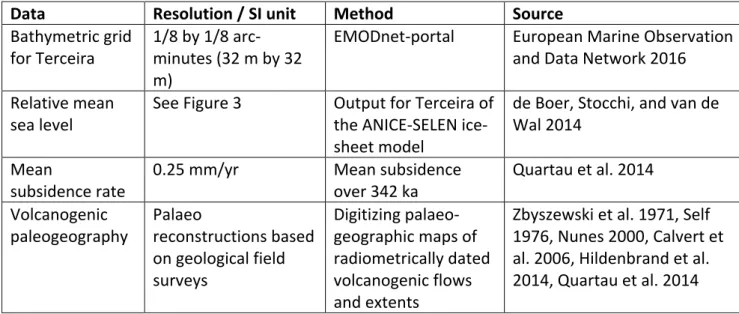
flows (see Fig. 2 for workflow, Table 1 for data sources, supplementary Table S1 for 259
calculated values, all raw data tabulated in an Excel sheet of supplementary Table S2). We 260
calculated the area changes based on present day bathymetric data with corrections for 261
changes in sea level, subsidence, landslide scars, and lava deltas (Fig. 2). 262
The areal effects were modelled over 120 ka, including one sea level rise and fall 263
cycle, with time steps of 10 ka resulting in 13 time slices. We used ESRI ArcGIS 10.2.2 264
desktop software to create contours for each time slice and calculate area changes based on 265
the differences between each time slice. We projected the maps in a Universal Transversal 266
Mercator system, which led to minimal area distortions (<1%) for the scale of our analysis 267
(<1–100 km2; Yildirim and Kaya 2008). All maps were georeferenced and collected in a
268
geodatabase. 269
We first used bathymetric data to construct the present-day coastal contour of Terceira. 270
Local sea level heights were combined with a bathymetric grid with a resolution of 1/8 by 1/8 271
arc-minutes (~32 by 32 m), which were obtained via the EMODnet portal (European Marine 272
Observation and Data Network, 2016). 273
Since the LGM ~22 ka ago, sea levels rose up to ~130 m globally and caused 274
disconnection of peninsular islands and partial drowning of continental, and some large 275
oceanic islands that fragmented and shrunk in size. Numerical modelling of the 276
palaeogeographic effects of sea level rise allows for quantifying timings and rates of 277
connectivity loss, fragmentation, and area reduction over time steps of 1,000 years for one or 278
more GI cycles. However, such a model must take into account all the interrelated physical 279
mechanisms that compose the Glacial Isostatic Adjustment process: (i) the ice- and water-load 280
induced solid Earth deformations, (ii) the change of mutual gravitational pull between 281
continental ice sheets and ocean, and (iii) the movements of the Earth’s rotational axis with 282
respect to the surface in response to surface ice- and water-load changes. These factors give 283
rise to regionally varying relative sea-level (RSL) changes that exponentially decay with time 284
because of the viscous response of the Earth’s mantle. 285
The ANICE-SELEN ice-sheet numerical model was used to model local relative sea 286
levels taking into account the flexibility of the Earth’s crust and the rheology of the mantle 287
(De Boer et al. 2014; Fig. 3, Appendix S2). The model was based on the solution of the 288
gravitationally self-consistent sea level equation and was used to reconstruct the RSL change 289
for the Azorean region through the last four GI cycles (420 ka). In the ice-sheet model, it was 290
assumed that ice melting in Greenland contributed +2 m equivalent sea level (esl) between 291
127 and 116 ka and Antarctica +5 m (esl) between 120 and116 ka. Therefore, the eustatic 292
highstand is a two-step feature. We constructed three curves with the ANICE-SELEN ice-293
sheet model that represent three realistic solutions based on different mantle viscosity profiles 294
(MVP) with a fixed lithosphere thickness of 100 km. 295
We corrected the relative sea levels with a constant subsidence rate of 0.25 mm/yr, 296
which represents an average rate of the subsidence of the insular shelves of the Cinco Pico 297
Volcanos and Guilherme Moniz volcano over a period of 370 ka (Quartau et al. 2014). For 298
this study, a relative MSL curve for the Azores was reconstructed for the timespan of the last 299
120 ka (Fig. 3, data in supplementary Table S2). The resulting relative sea level curve 300
deviates from the global eustatic MSL curve due to local geophysical effects, which include 301
(i) the ice- and water-load induced solid Earth deformations, (ii) the change of mutual 302
gravitational pull between continental ice sheets and ocean, and (iii) the movements of the 303
Earth’s rotational axis with respect to the surface in response to surface ice- and water-load 304
changes. These factors give rise to regionally varying relative sea-level (RSL) changes that 305
exponentially decay with time because of the viscous response of the Earth’s mantle. 306
For each time slice of 10 ka we compiled the maps of published radiometrically dated 307
volcanogenic flows and their extents (Fig. 4). In our quantification of area changes we 308
assumed that volcanic activity ceased between 120–90 ka, but there may be a data gap for this 309
period. We used the -108m MSL contour of Terceira as a contour representative for the local 310
maximum sea level lowering during the Last Glacial Maximum (LGM) 22 ka, when eustatic 311
sea levels reached up to -135m globally (Lambeck et al. 2014). Volcanogenic additions (lava 312
deltas) postdating 22ka were subtracted from the surface area. For the lowland coastal zone, 313
we assumed the inland upland border of the coastal plant communities to have remained static 314
over 120 ka at 300 m in elevation. The upper boundary most likely fluctuated in tandem with 315
temperature changes during glacials and interglacials, and community zones expanded 316
upwards with climatic warming and downwards with cooling (Fernándes-Palacios et al. 317
2016). Hence, for this work, we mainly looked at areal effects of an elevational zone from 318
prevailing sea level up to 300 m elevation, disregarding the altitudinal response of vegetation 319
communities. 320
RESULTS
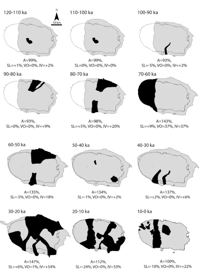
321All calculated values referred to in this section are tabulated and presented in supplementary 322
Table S1 and in Figure 4 and 5. 323
V
OLCANOGENIC CHANGE324
During the 120 ka timespan, the surface area of Terceira was only twice significantly affected 325
by volcanogenic flows and additions (Figs. 4 and 5). The most significant event was the 326
emergence of the Santa Bárbara volcano at around 60 ka, leading to a 37% increase in area 327
from 393 km2 to 571 km2 (Fig. 4). Later, between 30–20 ka, an increase of 1% in area
328
occurred by volcanogenic addition through eruptions by the Santa Bárbara volcano and the 329
Basaltic Fissures Area (Fig. 4). The two periods of increased volcanic activity affected major 330
parts of the interior of Terceira (Figs. 4, 5c). The first period was 8–50 ka when 18% to 37% 331
of the interior surface area was affected by volcanogenic flows, mainly from the active Santa 332
Barbára volcano. A second volcanically intense period occurred between 30 ka and present 333
times, when several volcanic systems were active. In this period, 22% to more than 50% of 334
the interior surface area was affected by volcanogenic flows (Fig. 5c, Table 2). The influence 335
of intra-island volcanic activity peaked in the coastal/lowland area at 31% 70–60 ka, and at 336
63% between 30 and20 ka, coinciding with highest magnitudes and rates of sea level falls 337
(Figs. 5d, 5e). 338
S
EA LEVEL CHANGE339
Sea levels affected on average 6% of the area of Terceira, with a positive peak of 9% surface 340
increase between 70–60 ka, coinciding with a sea level fall of 25 m in 10 ka and the 341
emergence of the Santa Bárbara volcano (Figs. 4, 5b). The greatest surface area reduction of 342
24%, occurring between 20–10 ka, coincided with the steepest rise in sea levels of 70 m in 10 343
ka (Fig. 4, Table 2). Sea level changed in absolute terms on average 11% of the total coastal-344
lowland area both positively and negatively, a factor two times lower than volcanogenic 345
activity (Table 2). Sea level changes affecting coastal-lowland areas peaked between 20–10 346
ka when sea level rise induced a reduction of 47% in coastal-lowland area, whereas a 347
maximum increase in coastal-lowland area of 13% occurred due to falling sea levels between 348
30–20 ka (Fig. 5e). 349
C
OMBINED CHANGE350
As a result of combined volcanogenic and sea level change, Terceira’s surface area changed 351
in size considerably over the last 120 ka, ranging between ca. 391 km2 and ca. 589 km2 (Table
352
2, Figs. 4 and 5). Although around 110 ka the caldera of Guilherme Moniz volcano was 353
created and sea level started to fall, until 70 ka, the total surface-area of Terceira remained 354
more or less constant around 385 +/- 10 km2 (Fig. 5a). From 70 ka BP onwards, combined
355
additions by pyroclastic flows and falling sea levels led to an increase of surface area of 356
Terceira by 200 km2, reaching up to a maximum of 589 km2. The surface area varied
357
minimally between 537–590 km2 for ca. 40 ka between 70–20 ka. The maximum size of
358
Terceira was reached between 30–20 ka, generated by the lowest sea level stand during the 359
LGM. We can conclude that at Terceira falling sea levels from 70 ka led to a maximum total 360
surface increase of ca. ~9% per 10 ka, representing one fourth of the incidental volcanogenic 361
addition of landmass through the formation of the Santa Bárbara volcano (~37%) at around 60 362
ka (Fig. 5b). The coastal-lowland area fluctuated between the smallest value, at present of 119 363
km2, and the highest of 304 km2, which also was reached during the LGM period (30–20 ka
364
ago; Table 2, Figs. 5d, 5e). This area remained more or less stable at ca. 200 km2 between
365
120–70 ka but increased up to 50% (ca. 300 km2) between 70–20 ka by volcanic activity and
366
sea level change. Again, also in the lowlands, two phases of net volcanic additions of 31% 367
occurred between 70–60 ka, due to the formation of the Santa Bárbara volcano, and 2% at 20 368
ka. On average, during active phases, 20% per 10 ka of the coastal-lowland surface area was 369
affected by volcanic activity, confirming the highly dynamic character of this area (Table 2). 370
Interestingly, the interglacial areas of Terceira remained more or less unchanged at 371
~400 km2 during the last and present-day interglacials, in spite of the permanent addition of
372
land mass generated by the formation of the Santa Bárbara volcano. However, the interglacial 373
surface area of the coastal-lowland area decreased permanently as compared to the previous 374
interglacial by 42% (from 203 km2 to 119 km2).
375
DISCUSSION
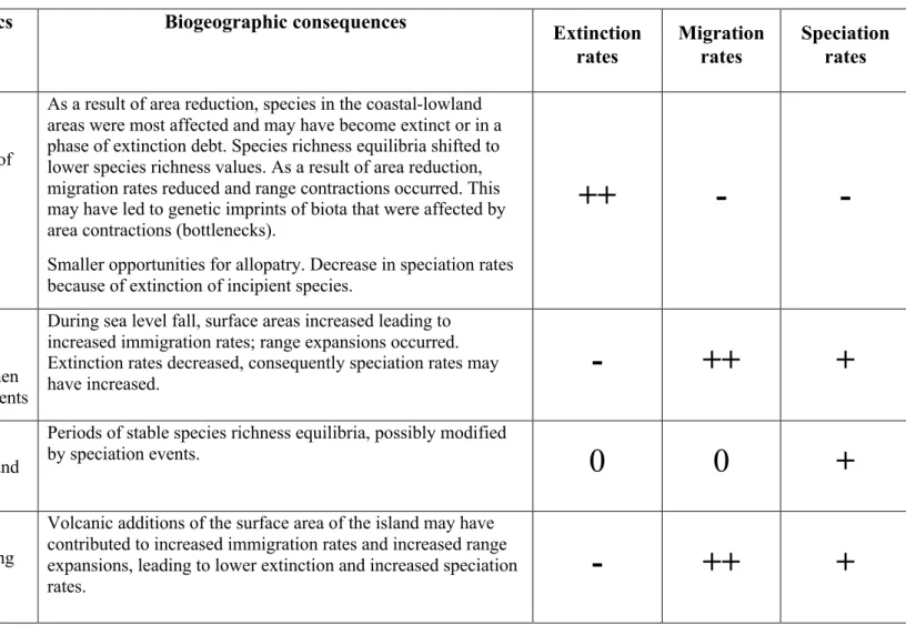
376Based on the magnitudes and rates of geospatial change identified for Terceira, we discuss the 377
hypothetical biogeographic and evolutionary effects on the terrestrial land locked biota of the 378
geospatial change on active volcanic oceanic islands. Our major conclusions are summarized 379
in Table 3. We are aware of other aspects of environmental change over glacial-interglacial 380
cycles that influence biogeographic processes, including global warming and cooling, as well 381
as changes in connectivity pathways by wind and water currents (Fernández-Palacios et al. 382
2016, Whittaker et al. 2017); but here we focus exclusively on discussing the implications of 383
geospatial change mediated by volcanogenic and sea level changes. 384
I
MPLICATIONS FOR THEG
LACIALS
ENSITIVEM
ODEL385
The most significant expansion of the area of Terceira over the past 120 ka, from 393 to >530 386
km2, was induced by the emergence of the Santa Barbara volcano around 60 ka (Figs. 4, 5).
387
This volcanogenic area increase occurred synchronous with sea level fall; the combination of 388
these two led to an area increase of 46% within 10 ka (Table S1). This large surface area 389
continued to exist between 60 ka until 20 ka (Fig. 5a). Interestingly, the typical dominance of 390
larger island size existing during glacial periods for more than 80% of the time (Norder et al. 391
2018) is barely noticeable at Terceira. The period of the smaller island size lasted ~50 ka, 392
from 120 ka to 70 ka, and the period of the larger island size lasted ~40 ka, from 60 ka to 20 393
ka. All the net area gained by volcanism was negatively compensated by the long-term net 394
subsidence of the island over this period. A key finding of this study is that volcanic additions 395
are spasmodic but long-lasting or permanent, whereas sea level changes are repetitive and 396
work on two directions over the Quaternary, inducing both periods of surface loss and surface 397
gain (Table 3). These processes lead us to present the following testable hypotheses about 398
how species richness may have been influenced by these changes, based on predictions from 399
the ETIB. 400
Between ~60–20 ka, when the island had its largest surface area, the island could have hosted 401
more species than before as immigration rates may have increased and extinction rates 402
decreased during this period. The volcanogenic addition of extra area, after 60 ka, may have 403
allowed a positive shift of equilibrium species richness, with increasing immigration rates and 404
decreasing extinction rates that lasted some 40 ka (Fig. 6a; Table 3). Indigenous biota may 405
have benefited from this 40 ka period by migrating and mixing their gene pools with the biota 406
from other islands. This 40 ka period may thus have been sufficient for attaining a dynamic 407
equilibrium in species richness (e.g., Fernández-Palacios et al. 2016). Perhaps this 40 ka 408
period of larger surface areas was also sufficient to initiate speciation processes in some 409
organisms (Table 3). In the period after 20 ka, due to sea level rise, the island shrunk by a 410
third, attaining its present size of 401 km2, while at the same time the inter-island distance
411
increased (Rijsdijk et al. 2014). Both area contraction and distance increase may have raised 412
extinction rates and generated extinction debts among some native species of Terceira (see 413
Rijsdijk et al. 2014, Norder et al. 2018). In particular, species restricted to the coastal-lowland 414
zone that expanded and contracted even more extremely (+87% to – 28% area change) were 415
affected. Possibly, the extreme contraction after 20 ka may have left genetic bottleneck 416
signatures still identifiable in the present-day native coastal-lowland species populations. 417
After 20 ka, the equilibrium species richness numbers may have shifted back downward to the 418
last interglacial/early glacial levels. The coastal-lowland geospatial dynamics may have also 419
promoted coastal species expansion to the interior of the islands as described in the taxon 420
cycle theory (Wilson 1961). Species that may have established after prolonged periods of 421
coastal expansion may then have been pushed into the adjacent uplands during coastal 422
contraction phases, inducing increased species interactions, and perhaps these sea level rise 423
periods coincided with inland genetic bottlenecks or anagenetic adaptation events. 424
At Terceira equilibrium processes may have occurred in tandem with the sea level cycles, as 425
predicted by the Glacial Sensitive Model (Fernández-Palacios et al. 2016). Volcanic 426
additions, however, which resulted in long-lasting land additions, may have shifted species 427
equilibria towards higher levels over longer periods (>60 ka) than sea level rise periods, 428
which pushed it downward over shorter periods (<20 ka) by decreasing areas (Table 3). 429
Volcanic additions led to spasmodic increases of surface areas facilitating long-lasting 430
increased opportunities of migrations and population expansions at Terceira occurring 431
between 70-20 ka BP (Fig. 6a: right panel; Table 3). This period may have enticed 432
recolonization events of species from adjoining islands, perhaps leading to increased 433
interspecific competition and reinforcing speciation processes (Losos and Ricklefs 2009, 434
Aguilée et al. 2011). Land loss by long-term subsidence, which at Terceira amounted to some 435
30 m over 120 ka, was compensated by volcanic additions. However, after the Holocene sea 436
level rise, the coastal-lowland area decreased by 42% relative to its previous interglacial 437
extent. Consequently, the coastal-lowland taxa had a much smaller area to inhabit and less 438
refuge options compared to the last interglacial period and may have experienced higher 439
extinction debts than during the previous interglacial state. This indicates that even over 440
climatic cycles, the vacant area options for taxa differ and thus highlight the complexity of 441
Glacial Sensitive Model assumptions over island area histories on volcanically active insular 442
settings. Volcanism also affects the height of islands (Clague and Sherrod 2014, Ramalho et 443
al. 2017) and topographic roughness (Seijmonsbergen et al. 2019), which also influence 444
migration rates gene flow and habitat diversity (Lim and Marshall 2019), adding still more 445
complexities that should be considered. 446
B
IOGEOGRAPHIC CONSEQUENCES OF INTRA-
ISLAND VOLCANISM447
While the effects of volcanism in total area expansion of Terceira was mainly limited by the 448
addition of the Santa Barbara Volcano at 60 ka, volcanic lava and pyroclastic flows were 449
active within the island over much of the past 120 ka. These volcanogenic flows covered 450
major parts of the islands, reaching more than 50% between 30–20 ka (Calvert et. al 2006, 451
Nunes et al. 2014). These flows sterilized vast areas, exceeding 60% of the coastal-lowland 452
area between 29–20 ka. During and shortly after the eruptions, these flows isolated patches of 453
vegetation known (in Hawaii) as “kīpukas”. The duration of the isolation periods of these 454
kīpukas prior to their re-connection through colonization of the surrounding sterilized grounds 455
must have depended on elevation, as biomass production rates associated with primary 456
succession decreases with elevation, as shown in Big Island, Hawaii (Aplet and Vitousek 457
1994). Depending on the thickness of the lava flows, the top of the lava solidifies to a stony 458
crust within hours, but it takes months to decades to fully solidify lava measuring meters to 459
tens of meters thick (Helz and Thornber 1987). Regardless of the volcanic substrate type 460
however within decades to centuries, providing climatic conditions are appropriate, rapid, and 461
continued succession from early colonizer species to forest species take place (Whittaker et al. 462
1989, Kitayama et al. 1995, Elias and Dias 2004). Weathering rates of lavas and subsequent 463
release of nutrients are positively related to mean annual temperature and influenced by net 464
annual rain fall (Crews et al. 1995). For tropical islands this signifies that at lower elevations 465
(<500 m), ca. 1 kg biomass/m2 may be produced within a decade, whereas at 1,000 m this
466
takes a century and at 2,000 m it may take several thousand years (Aplet and Vitousek 1994). 467
As a consequence, the durations of geomorphic and genetic separation take longer and, 468
therefore, the largest effects of genetic divergence are expected at higher elevations (Table 3). 469
On the Azores, such genetic effects may be reduced due to the temperate climate; biomass 470
production is probably lower at comparable heights for islands in the tropical realm, with not 471
much differentiation between the higher and lower regions. Altogether, the time steps of 10 ka 472
employed here exceed the ecological recovery and succession rates of the cooled lava flows 473
by nearly an order of magnitude, making it less likely that genetic or diversity patterns have 474
persisted over these time steps across the affected areas. However, genetic divergence 475
between populations that were separated by lava flows is observed with increasing effects on 476
older volcanoes (Gillespie and Roderick 2014). Although ecological recovery is faster, genetic 477
divergence may accumulate at each separation, so that after several separation cycles, 478
cumulative speciation is completed (Carson et al. 1990, Aguilée et al. 2011, Gillespie and 479
Roderick 2014). Therefore, if lava flows were sufficiently frequent, they may have left a 480
cumulative genetic imprint even on the time scale herein considered (Aguilée et al. 2009). An 481
example of this process may be represented by the single island endemic beetle Tarphius 482
relictus, which currently occurs exclusively in an isolated forest fragment surrounded by a 483
recent lava flow in which the Algar do Carvão lava tube is located (Borges et al. 2017). 484
I
MPLICATIONS FOR THEG
ENERALD
YNAMICM
ODEL485
According to the species pump hypothesis, the combined full island and intra-island 486
geospatial change may increase speciation events driven by both volcanic activity and sea 487
level fluctuations (Vandergast et al. 2004, Roderick et al. 2012, Aguilée et al. 2013, Gillespie 488
and Roderick 2014). Over an ontogenic cycle of a volcanic island, four stages can be 489
identified that influence species equilibria conditions and speciation processes (young island, 490
immature, mature, and old; see Table 2 of Ávila et al. 2019). The short-lasting early 491
emergence stage (phase I, Fig 6b) of volcanic islands is characterized by the highest 492
geospatial dynamics. Because surface areas are relatively small and heights relatively low, the 493
influence of both sea level change and volcanic additions is initially high (Fig. 6b-I). This 494
period is rapidly followed by the growing stage (phase II, which corresponds to the 495
young/immature island stages) that is dominated by spasmodic volcanic additions as the 496
volcanic island becomes larger and higher, and consequently the effect of sea level change on 497
area relatively diminishes (Fig. 6b-II). The species richness dynamics is dominated by 498
volcanogenic area additions, leading to increasing immigration and decreasing extinction 499
rates. Growth of the island during its young and immature ontogenic states continues to push 500
equilibria levels in a positive direction, facilitating species establishment, ecosystem 501
development, and trophic network development (Fig. 6a). Frequent volcanic intra-island area 502
changes are most pronounced and start to influence genetic signatures of settled populations. 503
When an island becomes disconnected from the magma sources (phase III, which corresponds 504
to the mature island stage; Fig. 6b-III), volcanism ceases and the island slowly erodes away 505
while also subsiding on a still flexible but cooling crust (Clague and Cherrod 2014). During 506
phase III, the island’s surface is typically characterized by a rough terrain due to erosion 507
(Seijmonsbergen et al. 2019). Later, in the post-eruptive stage of volcanic oceanic islands, the 508
crust cools further and subsidence rates decrease, characterizing phase IV, which corresponds 509
to the old island stage. Owing to the overall lowering of the island, the geospatial influence of 510
sea level fluctuations relatively increased at this time (Fig. 6b-IV). This trend may explain 511
why longer-lasting sea level stands left a signature on present-day endemic species (Norder et 512
al. 2019). This would imply that endemism is promoted on relatively young and active 513
volcanic islands due to the active volcanism and on old, inactive volcanic islands due to the 514
greater influence of sea levels. Towards the final ontogenic stage of volcanic islands when 515
they are nearly completely submerged, increasing extinction rates lead to a net species loss 516
(Whittaker et al. 2008). Emergent islands (phase I) are smoother, but (Seijmonsbergen et al. 517
2019) at least disallowing allopatric processes within the island (Borges and Hortal 2009). To 518
evolve endemic species, time is a key requisite (Heaney 2000), and on the Azorean islands the 519
most parsimonious model to explain single island endemism is mostly a linear product of area 520
and time (Borges and Hortal 2009). 521
It should be noted that subsidence is not necessarily the ontogenic end stage of a 522
volcanic island. Evidence from the oldest and volcanically inactive Azorean island, Santa 523
Maria, shows that after a 3.5 Ma initial phase of subsidence, isostatic and tectonic conditions 524
within the rift setting of the Azorean archipelago led to a prolonged phase of uplift of Santa 525
Maria of 0.04–0.06 mm/yr lasting from 3.5 Ma ago until present (Ramalho et al. 2017, Ricchi 526
et al. 2018). As a result, extensive marine platforms that were shaped during the last 3.5 Ma 527
emerged, and ultimately led to a doubling in size of Santa Maria to its present 96.9 km2 (Ávila
528
et al. 2010, Quartau et al. 2016). Such late re-uplift stages are also recorded for some of the 529
Hawaiian Islands with even faster vertical movements than the Azores, up to ~2 mm/yr over 530
the past 200 ka (Huppert et al. 2015). These peculiarities in island dynamics demonstrate that 531
island ontogenies and sea level histories should ideally be resolved on a per island basis 532
(Rijsdijk et al. 2014, Borregaard et al. 2017, Ávila et al. 2019). It is clear, however, that the 533
range in geospatial dynamics on different active volcanic oceanic islands generated by 534
regional volcanogenic sea level and vertical motion dynamics can be considered as different 535
modes of the species pump (in particular having different tempos) that have modified species 536
richness patterns (Aguilée et al. 2018). Quantifying the geospatial dynamics as highlighted 537
here provides a framework to test and assess how these different dynamic regimes are 538
reflected in genetic- or in species-richness patterns (Table 3). 539
Acknowledgements
540We thank the geo-scientists who unraveled and mapped the geohistory of Terceira, allowing 541
us to quantify its geospatial dynamics. We thank two anonymous reviewers (A and B), L.R. 542
Heaney and R.J. Whittaker for their critical but constructive feedback, which helped to 543
improve this paper. S.J.N. received funding from the Portuguese National Funds, through 544
Fundação para a Ciência e a Tecnologia (FCT), within the project UID/BIA/00329/2013 and 545
the Research Fellowship PD/BD/114380/2016. S.P.A. acknowledges his research contract 546
(IF/00465/2015) funded by the Portuguese Science Foundation (FCT). C.S.M. is benefiting 547
from a PhD grant M3.1.a/F/100/2015 from FRCT/Açores 2020 by Fundo Regional para a 548
Ciência e Tecnologia (FRCT). Financial support to R.A. was received from the Laboratory of 549
Excellence 'TULIP' (PIA-10-LABX-41). This work was supported by FEDER funds through 550
the Operational Programme for Competitiveness Factors – COMPETE and by National Funds 551
through FCT under the UID/BIA/50027/2013, POCI-01-0145-FEDER-006821 and under 552
DRCT-M1.1.a/005/Funcionamento-C-/2016 (CIBIO-A) project from FRCT. This work was 553
also supported by FEDER funds (in 85%) and by funds of the Regional Government of the 554
Azores (15%) through Programa Operacional Açores 2020, in the scope of the project 555
“AZORESBIOPORTAL – PORBIOTA”: ACORES-01-0145-FEDER-000072. The initiative 556
for this study was conceived after the second symposium in Island Biology held on Terceira 557 (Azores) in 2017. 558 559
Authors Contributions:
560KFR and SB initiated and led the research, SB analysed the data, all authors contributed 561
equally in discussions and writings. SS curated the data and workflow following the FAIR 562
guidelines for transparent scientific practices https://www.go-fair.org/fair-principles/. 563
564
Data Accessibility
565All GIS data produced for this paper is stored in a geodatabase in a publically assessable data 566 repository: 567 https://uvaauas.figshare.com/articles/File_geodatabase_containing_Terceira_GIS_data/12230834. 568 569
Supplementary Materials:
570The following materials are available as part of the online article from 571
https://escholarship.org/uc/fb: 572
Table S1. Area changes relative to the previous time slice of the total surface area of Terceira 573
and the coastal-lowland area due to volcanism and sea level changes. 574
Table S2. Raw tabulated data and geospatial analysis results. 575
References
577Ali, J.R. (2017) Islands as biological substrates: classification of the biological assemblage 578
components and the physical island types. Journal of Biogeography, 44, 984-994. 579
Ali, J.R. & Aitchison, J.C. (2014) Exploring the combined role of eustasy and oceanic island 580
thermal subsidence in shaping biodiversity on the Galápagos. Journal of 581
Biogeography, 41, 1227–1241. 582
Aguilée, R., Claessen D. & Lambert A. (2009) Allele fixation in a dynamic metapopulation: 583
founder effects vs refuge effects. Theoretical Population Biology, 76, 105-117. 584
Aguilée, R., Claessen D. & Lambert A. (2013) Adaptive radiation driven by the interplay of 585
eco-evolutionary and landscape dynamics. Evolution, 67, 1291-1306. 586
Aguilée, R., Gascuel F., Lambert A. & Ferriere R. (2018) Clade diversification dynamics and 587
the biotic and abiotic controls of speciation and extinction rates. Nature 588
Communications, 9, 3013. 589
Aguilée, R., Lambert, A. & Claessen D. (2011) Ecological speciation in dynamic landscapes. 590
Journal of Evolutionary Biology, 24, 2663-2677. 591
Aplet G.H. & Vitousek P.M. (1994) An age-altitude matrix analysis of Hawaiian rain-forest 592
succession. Journal of Ecology, 82, 137-147. 593
Ávila, S.P., A.C. Rebelo, A. Medeiros, C. Melo, C. Gomes, L. Bagaço, P. Madeira, P.A. 594
Borges, P. Monteiro, R. Cordeiro, R. Meireles & R. Ramalho. (2010) Os fósseis de 595
Santa Maria (Açores). 1. A jazida da Prainha, 103 pp. OVGA – Observatório 596
Vulcanológico e Geotérmico dos Açores, Lagoa. 597
Ávila, S.P., Cordeiro, R., Madeira, P., Silva, L., Medeiros, A., Rebelo, A. C., Melo, C., Neto, 598
A. I., Haroun, R., Monteiro, A., Rijsdijk, K. F. & Johnson, M. E. (2018a) Global 599
change impacts on large-scale biogeographic patterns of marine organisms on Atlantic 600
oceanic islands. Marine Pollution Bulletin, 126, 101–112. 601
Ávila, S.P., Ramalho R., Habermann J.and Titschack, J. (2018b) The marine fossil record at 602
Santa Maria Island (Azores). In: Kueppers, U. & C. Beier (Eds), Volcanoes of the 603
Azores. Revealing the Geological Secrets of the Central Northern Atlantic Islands. 604
Active Volcanoes of the World. Springer, Berlin, Heidelberg: 155-196. 605
https://doi.org/10.1007/978-3-642-32226-6_9. 606
Ávila, S.P., Melo C., Sá N., Quartau R., Rijsdijk K.F., Ramalho R.S., Berning B., Cordeiro 607
R., de Sá N.C., Pimentel A., Baptista L., Medeiros A., Gil A. & Johnson M.E. (2019) 608
Towards a “Sea-Level Sensitive Marine Island Biogeography” model: the impact of 609
glacio-eustatic oscillations in global marine island biogeographic patterns. Biological 610
Reviews 94, 1116-1042. 611
Borges, P.A.V., Amorim, I.R., Terzopoulou, S., Rigal, F., Emerson, B. & Serrano, A.R.M. 612
(2017) Cryptic diversity in Azorean beetle genus Tarphius Erichson, 1845 613
(Coleoptera: Zopheridae): An integrative taxonomic approach with description of four 614
new species. Zootaxa, 4236, 401-449. 615
Borges, P.A.V. & Hortal, J. (2009) Time, area and isolation: factors driving the diversification 616
of Azorean arthropods. Journal of Biogeography, 36, 178–191. 617
Borregaard, M.K., Amorim, I.R., Borges, P.A.V., Cabral, J.S., Fernández-Palacios, J.M., 618
Field, R., Heaney, L.R., Kreft, H., Matthews, T.J., Olesen, J.M., Price, J., Rigal, F., 619
Steinbauer, M., Triantis, K.A., Valente. L., Weigelt, P. & Whittaker, R.J. (2018) 620
Oceanic island biogeography through the lens of the General Dynamic Model: 621
assessment and prospect. Biological Reviews, 92, 830–853. DOI:10.1111/brv.12256 622
Calvert, A.T., Moore, R.B., Mcgeehin, J.P. & Silva, R.D. (2006) Volcanic history and 40Ar/ 623
39Ar and 14C geochronology of Terceira Island, Azores, Portugal, Journal of 624
Volcanology and Geothermal Research, 156, 103-115. 625
Carson, H. & Johnson, W. (1975) Genetic Variation in Hawaiian Drosophila I. Chromosome 626
and allozyme polymorphism in D. setosimentum and D. ochrobasis from the Island of 627
Hawaii. Evolution, 29, 11-23. doi:10.2307/2407138 628
Carson, H.L., Lockwood, J.P. & Craddock, E.M., 1990. Extinction and recolonization of local 629
populations on a growing shield volcano. Proceedings of the National Academy of 630
Sciences USA, 87, 7055-7057. 631
Clague, D.A. & Cherod, D.R. (2014) Chapter 3: Growth and degradation of Hawaiian 632
volcanoes in characteristics of Hawaiian volcanoes (Eds. Poland M.P., Takhashi TJ, 633
Ladowski C.M.) U.S. Geological Survey Profession Paper, 1801, 79-141. 634
Crews, T.E., Kitayama, K., Fownes, J.H., Riley, R.H., Herbert, D.A., Mueller-Dombois, D., 635
Vitousek, P.M. (1995) Changes in phosphorous fractions and ecosystem dynamics 636
across a long chronosequence in Hawaii. Ecology, 76, 1407-1424. 637
De Boer, B., Stocchi, P. & van de Wal, R.S.W. (2014) A fully coupled 3-D ice-sheet – sea-638
level model: algorithm and applications, Geoscientific Model Development 639
Discussions, 7, 3505-3544. 640
Diamond, J.M. (1972) Biogeographic Kinetics: Estimation of relaxation times for avifaunas 641
of Southwest Pacific Islands, Proceedings of the National Academy of Sciences USA, 642
69, 3199-3203. 643
Diamond, J.M. & Gilpin M.E. (1983) Biogeographic umbilici and the origin of the Philippine 644
avifauna, Oikos, 41, 3017-321. 645
Dias, E. (1996) Vegetação natural dos Açores. Ecologia e sintaxonomia das florestas naturais. 646
Ph.D. Dissertation, Departamento de Ciências Agrárias, Universidade dos Açores. 647
Angra do Heroísmo, Azores, PT. 648
Elias, R.B., Gil, A., Silva, L., Fernández-Palacios, J.M., Azevedo, E.B. & Reis, F. (2016) 649
Natural zonal vegetation of the Azores Islands: characterization and potential 650
distribution. Phytocoenologia, 46, 107-123. DOI:10.1127/phyto/2016/0132 651
Elias, R.B. & E. Dias, E. (2004) Primary succession on lava domes on Terceira (Azores). 652
Journal of Vegetation Science, 15, 331-338. 653
European Marine Observation and Data Network (2016) European Marine Observation and 654
Data Network portal. Available: http://www.emodnet-bathymetry.eu/. 655
Féraud, G., Kaneoka, I. & Allègre C.J. (1980) K/Ar ages and stress patterns in the Azores: 656
Geodynamic implications. Earth and Planetary Science Letters, 46, 276-286. 657
Fernández-Palacios, J.M., Otto, R., de Nascimento, L., Fernández-Lugo, S., Whittaker, R.J., 658
Rijsdijk, K.F., Norder, S.J. & Tjørve, E. (2016) Towards a glacial-sensitive model of 659
island biogeography. Global Ecology and Biogeography, 25, 817–830. 660
Gabriel, R., M.M.C. Coelho, D.S.G. Henriques, P.A.V. Borges, R.B. Elias, J. Kluge & Ah– 661
Peng C. (2014) Long–term monitoring across elevational gradients to assess 662
ecological hypothesis: a description of standardized sampling methods in oceanic 663
islands and first results. Arquipelago. Life and Marine Sciences, 31: 45–67. 664
Gertisser, R., Self, S., Gaspar, J.L., Kelley, S.P., Pimentel, A., Eikenberg, J., Barry, T.L., 665
Pacheco, J.M., Queiroz, G. & Vespa, M. (2010) Ignimbrite stratigraphy and 666
chronology on Terceira Island, Azores. Geological Society of America Special Papers, 667
464, 133-154. 668
Gillespie, R.G. & Roderick, G.K. (2014) Geology and climate drive diversification. Nature, 669
509, 297–298. 670
Heaney, L.R. (1986) Biogeography of mammals in SE Asia: estimates of rates of 671
colonization, extinction and speciation. Biological Journal of the Linnean Society, 28, 672
127– 165. 673
Heaney, L.R. (2000) Dynamic disequilibrium: a long-term, large-scale perspective on the 674
equilibrium model of island biogeography. Global Ecology and Biogeography, 9, 59-675
74. 676
Helz, R.T. & Thornber, C. R. (1987) Geothermometry of Kilauea Iki lava lake, Hawaii. 677
Bulletin of Volcanology, 49, 651-668. 678
Hildenbrand, A., Weis, D., Madureira, P. and Marques, F. (2014) Recent plate re-organization 679
at the Azores Triple Junction: Evidence from combined geochemical and 680
geochronological data on Faial, S. Jorge and Terceira volcanic islands, Lithos, 210, 681
27-39. 682
Huppert, K.L., Royden, L.H., Perron, J.T. (2015) Dominant influence of volcanic loading on 683
vertical motions of the Hawaiian Islands. Earth and Planetary Science Letters, 418, 684
149-171. 685
Kitayama, K, Mueller-Dombois, D. & Vitousek, P.M. (1995) Primary succession of Hawaiian 686
montane rain forest on a chronosequence of eight lava flows. Journal of Vegetation 687
Science, 6, 211-222. 688
Lambeck, K., Rouby, H., Purcell, A., Sun, Y. & Sambridge, M. (2014) Sea level and global 689
ice volumes from the Last Glacial Maximum to the Holocene. Proceedings of the 690
National Academy of Sciences USA, 111, 15296–303. 691
Lim, J.Y. & Marshall, C.R. (2017) The true tempo of evolutionary radiation and decline 692
revealed on the Hawaiian archipelago. Nature, 543, 710. 693
Losos, J.B. & Ricklefs, R.E. (2009) Adaptation and diversification on islands. Nature, 457, 694
830. 695
Lourenço, N., Miranda, J.M., Luís J.F., Ribeiro, A., Mendes Victor, L.A., Madeira, J. & 696
Needham, H.D. (1998) Morpho-tectonic analysis of the Azores Volcanic Plateau from 697
a new bathymetric compilation of the area. Marine Geophysical Research, 20, 141-698
156. 699
Madeira, J. (2005) The volcanoes of Azores island: A world-class heritage (examples from 700
Terceira, Pica and Faial Islands) Field Trip Guide Book, LATTEX - Faculdade de 701
Ciências da Universidade de Lisboa, Lisbon, Portugal. 702
Madeira J., Brum da Silveira A., Hipólito A., Carmo R. (2015) Active tectonics in the central 703
and eastern Azores islands along the Eurasia–Nubia boundary: a review. In: Gaspar, 704
J.L., Guest, J.E., Duncan, A.M., Barriga, F.J.A.S., Chester D.K. (eds.) Geological 705
Society, London, Memoirs, 44, 15-32 706
MacArthur, R.H. & Wilson, E.O. (1963) An equilibrium theory of insular zoogeography. 707
Evolution, 17, 373-387. 708
Marques, F.O., Catalão, J., Hildenbrand, A., Madureira, P., 2015. Ground motion and 709
tectonics in the Terceira Island: Tectonomagmatic interactions in an oceanic rift 710
(Terceira Rift, Azores Triple Junction). Tectonophysics, 651, 19-34. 711
Marques, F.O., Hildenbrand, A., Zanon, V., Boulesteix, T., 2016. Comment on “The insular 712
shelves of the Faial–Pico Ridge (Azores archipelago): a morphological record of its 713
evolution” by Quartau et al. (2015) Geochemistry, Geophysics, Geosystems, 17, 625– 714
632 715
Milne, G.A. & Mitrovica, J.X. (2008) Searching for eustasy in deglacial sea-level histories. 716
Quaternary Science Reviews 27, 2292-2302. 717
Miranda, J.M., Navarro, A., Catalão, J., Fernandes, R.M.S. (2012) Surface displacement field 718
at Terceira Island deduced from repeated GPS measurements. Journal of Volcanology 719
and Geothermal Research, 217-218, 1-7. 720
Norder, S.J., Baumgartner, J.B., Borges, P.A.V., Hengl, T., Kissling, W.D., van Loon, E.E. 721
Rijsdijk, K.F. (2018) A global spatially explicit database of changes in island palaeo 722
area and archipelago configuration during the late Quaternary. Global Ecology and 723
Biogeography, 27, 500-505. DOI: 10.1111/geb.12715. 724
Norder, S.J., Proios, K., Whittaker, R.J., Alonso, M.R., Borges, P.A.V., Borregaard, M.K., 725
Cowie, R.H., Florens, F.B.V., de Frias Martins, A.M., Ibáñez, M., Kissling, W.D., de 726
Nascimento, L., Otto, R., Parent, C.E., Rigal, F., Warren, B.H., Fernández-Palacios, 727
J.M., van Loon, E.E., Triantis, K.A. & Rijsdijk, K.F. (2019) Beyond the Last Glacial 728
Maximum: Island endemism is best explained by long-lasting archipelago 729
configurations. Global Ecology and Biogeography, 28, 184–197. 730
Nunes, J. (2000) Notas sobre a geologia da Ilha Terceira. Acoreana, 9, 205–215. 731
Nunes, J.C., Calvert, A., Medeiros, S., Lima, E.A., Pereira, F., Costa, M.P., Barcelos, P. & 732
Carvalho, M.R. (2014) Geological mapping of the central area of Terceira Island 733
(Azores, Portugal): associated volcanostratigraphy, ages and genetic implications on 734
the Malha-Balcões-Chamusca lava caves system. Comunicações Geológicas, 101, 735
283-288. 736
Nunes, J.C. (2017) Cartografia vulcanostratigráfica do campo geotérmico do Pico Alto (ilha 737
Terceira, Açores). Açoreana, 11, 59-88. 738
Otto, R., Whittaker, R.J., Gaisberg, M., Stierstorfer, C., Naranjo Cigala, A., Steinbauer, M.J., 739
Borregaard, M.K., Arévalo, J.R., Garzón Machado, V., Arco, M. & Fernández 740
Palacios, J.M. (2016) Transferring and implementing the general dynamic model of 741
oceanic island biogeography at the scale of island fragments: the roles of geological 742
age and topography in plant diversification in the Canaries. Journal of Biogeography, 743
43, 911-922. 744
Quartau, R., Trenhaile, A.S., Mitchell, N.C., Tempera, F. (2010) Development of volcanic 745
insular shelves: Insights from observations and modelling of Faial Island in the Azores 746
Archipelago. Marine Geology, 275, 66-83. 747
Quartau, R., Hipólito, A., Romagnoli, C., Casalbore, D., Madeira, J., Tempera, F., Roque, C. 748
& Chiocci, F.L. (2014) The morphology of insular shelves as a key for understanding 749
the geological evolution of volcanic islands: Insights from Terceira Island. 750
Geochemistry, Geophysics, Geosystems, 15, 1801-1826. 751
Quartau, R., Madeira, J., Mitchell, N.C., Tempera, F., Silva, P.F., Brandão, F. (2015) The 752
insular shelves of the Faial-Pico Ridge: a morphological record of its geologic 753
evolution (Azores archipelago). Geochemistry, Geophysics, Geosystems, 16, 1401– 754
1420. 755
Quartau, R., Hipólito, A., Mitchell, N.C., Gaspar, J.L., Brandão, F. (2015b) Comment on 756
“Construction and destruction of a volcanic island developed inside an oceanic rift: 757
Graciosa Island, Terceira Rift, Azores” by Sibrant et al. (2014) and proposal of a new 758
model for Graciosa geological evolution [Journal of Volcanology and Geothermal 759
Research 284 (2014) 32-45]. Journal of Volcanology and Geothermal Research, 303, 760
146-156. 761
Quartau R., Madeira J., Mitchell N.C., Tempera F., Silva P.F., Brandão F. (2016) Reply to 762
comment by Marques et al. on “The insular shelves of the Faial-Pico Ridge (Azores 763
archipelago): A morphological record of its evolution”. Geochemistry, Geophysics, 764
Geosystems, 17633-641. 765
Ramalho, R.S., Quartau, R., Trenhaile, A.S., Mitchell, N.C., Woodroffe, C.D., Ávila, S.P. 766
(2013) Coastal evolution on volcanic oceanic islands: A complex interplay between 767
volcanism, erosion, sedimentation, sea-level change and biogenic production. Earth 768
Science Reviews, 127, 140-170. 769
Ramalho, R.S., Helffrich, G., Madeira, J., Cosca, M., Thomas, C., Quartau, R., Hipólito, A., 770
Rovere, A., Hearty, P.J. & Ávila, S.P. (2017) Emergence and evolution of Santa Maria 771
Island (Azores)—The conundrum of uplifted islands revisited. Geological Society of 772
America Bulletin, 129, 372-390. 773
Ricchi, A., Quartau, R., Ramalho, R.S., Romagnoli, C., Casalbore, D., Ventura da Cruz, J., 774
Fradique, C., Vinhas, A. (2018) Marine terraces development on reefless volcanic 775