drilling data, as well as to analyse and interpret seismic lines.
3D object manipulation helps students acquire spatial vision. There are open-source programs for educational purposes, but most commercial soft-ware require purchasing licenses at prices as high as thousands of dollars. In the academy, for most university courses, acquisition can occur only in exceptional cases. In Brazil, educational investiga-tors pay low attention to the subject. This research project seeks to produce models of subsurface geological structure of three Brazilian sedimenta-ry basins, as well as 3D computational modeling guides for didactic purposes in Geosciences.
Terræ
DidaticaIntroduction
Three-dimensional modeling connects many fields of basic and applied knowledge. High-level skills linked to spatial thinking are essential for any Geosciences professional, being an indispensable aspect for professional training in Earth Sciences (King 2008). Thus, specific disciplines of Geology undergraduate courses seek to develop such skills.
In the case of simple or complex geological structures, there is a challenge for training specia-lists and for developing data management applica-tions. Investment in the oil and mining industry, from companies, universities and research centers, has generated sophisticated resources to process
ARTIGO
Abstract: Three-dimensional modeling connects several fields of knowledge, both basic and applied. 3D models are relevant in educational research because the manipulation of 3D objects favors the acquisition of spatial vision by the students, but there are few didactic publications in Portuguese on the subject for Geosciences. The authors are developing an educational research project to produce three-dimensional models of didactic examples of sedimentary basins: the Paraná Basin (Silurian-Upper Cretaceous), the Taubaté and the São Paulo basins (Neogene). 3D-compatible files will be produced to compose didactic and display material, from maps and geological-structural profiles of certain regional stratigraphic levels of each basin. The research challenges are: (a) to obtain an overview of the available resources for 3D modeling; (b) to evaluate their potential, characteristics, advantages and limitations for application in Geology and Geosciences; (c) to create computational models of the basins; (d) to produce at least one physical model based on one of the computational models of each basin. The resources will subsidize training workshops for in-service teachers, technical-scientific articles and Internet pages.
Manuscript:
Received: Quadrennial Conference of the International Geoscience Education Organization
Accepted: 14/01/2018
Citation: Carneiro C.D.R, Santos K.M., Lopes T.R.,
Santos F.C., Silva J.V.L, Harris A.L.N.C. 2018.Three--dimensional physical models of sedimentary basins as a resource for teaching-learning of geology. Terræ
Didatica, 14(4):379-384. URL:
http://www.ige.uni-camp.br/terraedidatica/.
Keywords: Teaching-learning, 3D models, sedimentary
basins, Geology, Geosciences, science popularization.
Thematic line: Geosciences and Natural Sciences for
Basic Education.
Three-dimensional physical models of sedimentary basins
as a resource for teaching-learning of geology
M
odelosfísicostridiMensionaisdebaciassediMentarescoMorecursoparaensino-
aprendizageMdeg
eologiacelso dal ré carneiro1,2, Kauan Martinsdos santos3, thiago rivaben lopes3, filipe constantinodos santos3, Jorge vicente lopesda silva4, ana lucia
nogueirade caMargo harris5
1 - Geosciences institute, universityof campinas, Graduate proGramof teachinGand historyof earth sciences, campinas, sp, Brazil.
2 - cnpq Grant.
3 - Geosciences institute, universityof campinas, underGraduatestudentof GeoloGy. campinas, sp.
4 - renato archer information technoloGy center (itc). campinas, sp.
5 - facultyof civil enGineerinGand architecture, universityof campinas, campinas, sp.
e-mail: [email protected], [email protected], [email protected], [email protected], [email protected], luharris@fec. unicamp.Br, [email protected]
If millions of people make 3D models or digitize the real world in 3D, why would they share that in 2D? YouTube made it for video creators, or SoundCloud for musicians, we want to do for 3D creators (Sketchfab 2016).
Agisoft PhotoScan is a commercial photo-grammetric digital image processing software that generates 3D spatial data of objects at various scales for use in GIS applications, cultural heritage docu-mentation and production of visual effects.
Many research groups investigate the nature and the particular way by which a student deve-lops his/her 3D visualization capability. Kastens et al. (2011), after investigating critical learning issues, offered proposals to improve education (see a report on Spatial Thinking. Professional
Develop-ment to Improve the Spatial Thinking of Earth Science Teachers and Students, URL http://earth2class.org/
site/?page_id=2957).
Each physical model developed to support Geoscience teaching should be accompanied by a didactic guide for use in practical classes. The guide should include general and specific information about the selected basin, its structure and evolu-tion. At least three 3D geological models will be created: (a) 3D-model of the Palaeozoic-Mesozoic Paraná Basin; (b) 3D-model of the neogenic São Paulo Basin; (c) 3D-model of the neogenic Tauba-té Basin (Fig. 1). Critical subsurface data of these basins are available, which allows production of updated models without collecting more data from petroleum companies or agencies such as ANP (National Petroleum Agency):
• Paraná Basin (Almeida 1980, Zalán et al. 1987, Mantesso-Neto et al. 2004, Milani et al. 1994, Oliveira & Carneiro 2008, Soares et al. 2007a, 2007b, 2008, 2009).
• São Paulo Basin (Hasui et al. 1976, Takiya 1991, Takiya et al. 1989, 1990).
• Taubaté Basin (Carneiro et al. 1976, Hasui & Ponçano 1978, Marques 1990, Carvalho et al. 2011, Fernandes & Chang 1992, 2001, 2003, Padilha et al. 1991).
Stereology and 3D visualization
The ability to visualize geological structures within solid rock masses is critical for geologists and other professionals. It depends on the learner to develop, or to construct, a visual penetrative
Research goals and objectives
The educational research project belongs to the area of Structural Geology and Three-Dimensional Visualization, articulating the production of basin--model representations and 3D models of geolo-gical structures for developing didactic and display materials of geological structures at various scales using 3D printing resources. This requires research about 3D representation in Structural Geology and resources for modeling geological structures, from the theoretical foundations of mapping using isopacs, isochors and structural contour maps (Ragan 1973).
The research team should explore platforms and environments that allow any person to gene-rate and publish 3D content online. The project should produce new didactic resources to improve geological 3D visualization, with the support of the Renato Archer Information Technology Center. The examples will increase in the future, including new physical models of sedimentary basins.
3D printing, technically known as additive manufacturing, is composed of a set of techno-logies based on various physical and/or chemical principles to automatically produce, from a virtual 3D model, a physical model using the controlled deposition of layers of materials. This allows, in many areas of knowledge, to represent structures with complex geometries not possible by conven-tional production processes (Volpato et al. 2017).
The expected products are physical models produced in state-of-the-art 3D printers. The generation of digital and physical 3D models of selected rocky bodies and sedimentary basins relies on geo-interpreted representations such as charts, maps, images, photographs and geological--structural profiles.
Development of 3D Geo-Structural Models
The universe of digitalization and publication of three-dimensional models evolves in a fantastic pathway, not only in the cinema and industry but also in the educational field. The internet has been a lavish source of 3D viewing capabilities. Three good examples are Sketchfab (URL: https://ske-tchfab.com), Visible Geology (URL: http://app. visiblegeology.com/) and Agisoft PhotoScan (URL http://www.agisoft.com/) among others. The first two belong to the category of open access programs, but the use is restricted to specific platforms. An issue that has been posed by systems like Sketchfab is simple and fairly current:properties of space as a vehicle for structuring problems, formulating questions and proposing solutions. The authors point to the fact that in the USA the educational system rarely includes the ability of spatial reasoning in the contents treated in Earth sciences. A similar situation occurs in Brazil, where Geosciences contents are studied in a fragmented way in several disciplines, which makes it even more difficult to develop such skills.
The quality of a model is a direct function of the quality and quantity of the available data from boreholes or fieldwork. The difficulty increases if the data are poorly distributed or insufficient (Pollard & Fletcher 2005). To improve 3D repre-sentation of rock formations, geological interpre-tations should ideally be made from the outset in a three-dimensional environment (Groshong Jr. 2006). A geological model is usually composed of three parts or aspects (Munier 2004): (1) a model that describes the geometry and properties of several units and/or lithological domains at various scales; (2) a structural model that also describes the
geometry and properties of deformation zones; (3) the arrangement of fractures and/or other structu-res within the lithological units.
[…] fractures and small deformation zones are too small to be described in a deterministic man-ner and therefore must be statistically described in terms of the various distributions and their relations (Munier 2004, p.6).
Stereology techniques help produce increa-singly sophisticated 3D models basically by the extraction of 3D parameters from measurements obtained in 2D sections (Kuiper 2008).
Stereology-based programs allow to process digital images and to generate stereoscopic images, such as 3D images of seismic zones (Wells 2002). Manipulation of static images can use the OpenS-tereo program (Gomes Neto et al. 2007, Leite n.d.). Pomaska (2011) has processed dynamic images to create stereoscopic 3D images after recording them on video. Other systems deal with high resolution images constructed from digital elevation models Figure 1. Subsurface structural contouring of the basement of the Taubaté
Basin (Neogene). Source: T.R. Lopes (2017) ability (Kastens et al. 2009,
Kuiper 2008).
The use of computers may help, or hinder (Oppenheimer 1997), the achievement of many required skills (Schlis-che & Ackermann 1998, Wells 2002), but this kind of research is scarce in Brazil.
Three-dimensional mode-ling resources may support conveying ideas, using real--world miniatures, which act as tools for recording and improving concepts. Insofar as they stimulate cognitive gains, they contribute to the deve-lopment of visio-spatial per-ception and learning of visual language. Kastens et al. (2014) argue that in Earth Scien-ce spatial thinking involves “envisioning, manipulating, or drawing meaning from the position, shape, orientation, trajectory, or configuration of objects or phenomena, or groups of objects or pheno-mena”.
Paulo and Taubaté, despite the diversity of scale, may be important for improving subsurface geolo-gical data processing at the University of Campinas.
The models open the possibility of didactic use of 3D models, thus attracting the interest of teachers and students for research and educational work. The easy visualization provided by 3D print capabilities can enhance new educational methods and introduce new functions and adaptations of the models, depending on the needs of the professio-nals who are dedicated to this area of study. Models will be further tested and refined before coming into a fully public domain, thus being accessible to external experts and interested people.
Acknowledgements
The authors are grateful to the National Coun-cil for Scientific and Technological Development (CNPq) for a Research Productivity grant to one author (CDRC) and Scientific Initiation Scholar-ship Program of CNPq for Scientific Initiation grants, which enabled the research. The authors acknowledge the stimulating opinion of two for accurate estimation of layer orientation data
(Fernández 2005, Cracknell et al. 2012).
Teaching and learning of Structural Geology is a prerequisite for improving the ability of stu-dents to visualize structures in space, an essential prerequisite for understanding rock arrangements and their spatial distribution, as presented in maps (Ragan 1973, Hobbs et al. 1976, Ramsay & Huber 1983, 1987, Davis & Reynolds 1996, Twiss & Moores 1992, Lisle 1995, Groshong Jr. 2006). It is relatively easy to find texts in Portuguese on computer-aided design (CAD) (see, eg, Bizello & Ruschel 2007), but they are scarce in geology. Jacobson (2001a, 2001b) provides examples of the use of CAD for resolving exercises in Structural Geology, such as structural contour lines, depth and thickness of layers, three-point problem and dive determination from apparent dives. The exer-cises using CAD in two- and three-dimensions are consistent with manual resolutions (Carneiro & Carvalho 2008, 2012).
Use of Global Positioning Systems (GPS) has been common in field data acquisition (Pollard & Fletcher 2005), requiring an intensive use of geo-processing software for data geo-processing. In order to construct a 3D geological model it is necessary to have an adequate sample of three-dimensional data (Wu et al. 2005).
Discussion
Production of three-dimensional models of basins motivated surveys by undergraduate stu-dents of Unicamp. For example, H.V.B. de Oliveira concluded in late 2009 a subsurface model of the Guarani Aquifer System, generating a Paraná Basin database in ArcGIS environment (Oliveira & Car-neiro 2008). She compiled data from unpublished reports and publications, such as Almeida (1980), Zalán et al. (1986, 1991), Milani et al. (1994) and Mantesso-Neto et al. (2004).
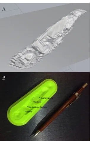
The new 3D representations of the Paraná Basin will incorporate more data, always keeping a focus on the giant Guarani Aquifer. These models as well as the 3D representations of the São Paulo and Taubaté basins (Fig. 2) can help studies about underground water resources in these regions.
Conclusions
The development of 3D models for didactic examples of sedimentary basins, such as Paraná, São
Figure 2. Subsurface models of: (A) structural contours. (B) Physical 3D model of the Taubaté Basin (Neogene) A
ARSS.20074423744. Acesso 14.04.2018.
Groshong Jr. R.H. 2006. 3-D Structural Geology: a prac-tical guide to quantitative surface and subsurface map interpretation. New York, Springer, 400p. (CD-ROM incl.).
Hasui Y., Ponçano W.L. 1978. Organização estrutural e evolução da Bacia de Taubaté. In: SBG, Congr. Bras. Geol., 30, Recife, 1978. Anais..., Recife, v. 1, p. 368-381.
Hobbs B.E., Means W.D., Williams P.F. 1976. An outline
of Structural Geology. New York: John Wiley.
Jacobson C.E. 2001a. Using AutoCAD for descriptive geometry exercises in undergraduate structural ge-ology. Computers & Geosciences, 27(1):9-15.
Jacobson C.E. 2001b. Using AutoCAD for Descriptive Geometry Exercises in Undergraduate Structural Geology (Expanded version of manuscript pub-lished in Computers & Geosciences 27(1):9-15. URL:
http://portal.acm.org/citation.cfm?id=372821. DOI 10.1016/S0098-3004(00)00060-1. Accessed 25.11.2017.
Kastens K., Manduca C.A., Cervato C., Frodeman R., Goodwin C., Liben L.S., Mogk D.W., Span-gler T.C., Stillings N.A., Titus S. 2009. How Geoscientists Think and Learn, Eos Trans. AGU,
90(31):265. (Unedited Preprint). URL: http://
serc.carleton.edu/serc/EOS-90-31-2009.html. Ac-cessed 26.11.2017.
Kastens K.A., Passow M.J., Pistolesi L. 2014. Analy-sis of Spatial Concepts, Spatial Skills and Spa-tial Representations in New York State Regents Earth Science Examinations. J. Geosc. Educ.,
62:278-289. URL: http://www.nagt-jge.org/ doi/
pdf/10.5408/13-104.1. Accessed 09.11.2017. Kastens K.A., Pistolesi L. Passow M.J., 2011. Spatial
Thinking. Professional Development to Improve
the Spatial Thinking of Earth Science Teachers and Students. Supported by National Science Founda-tion GEO-1034994. URL: http://earth2class.org/ site/? page_id=2957. Accessed 09.11.2017. Kincal C. 2014. Application of two new stereographic
projection techniques to slope stability prob-lems. Intern. J. Rock Mechanics & Mining Sciences,
66:136-150. URL: http://www.sciencedirect.com/
science/article/pii/S1365160914000264. Accessed 03.01.2018.
Kuiper I.D. 2008. The dry-erase cube: making three-dimensional visualization easy. J. Geosc. Educ.,
56(3):261-286.
Leite P.J.S. s.d. OpenStereo: uma biblioteca para sporte ao desenvolvimento de aplicações estereoscópicas. Recife: Univ. Fed. Pernambuco, C. Informática. (Trab. Grad. Ciência da Comput.). URL: http:// www.cin.ufpe.br/~tg/2006-1/pjsl.pdf. Acesso 15.06.2018.
Lisle R.J. 1995. Geological structures and maps. 2 ed. Ox-ford: Butterworth-Heinemann. 104p.
Mantesso-Neto V., Bartorelli A., Carneiro C.D.R., Brito-Neves B.B.de. orgs. 2004. Geologia do
Conti-nente Sul-Americano: Evolução da obra de Fernando
Flávio Marques de Almeida. São Paulo: Ed. Beca. 673p. ISBN 85-87256-45-9.
Marques A. 1990. Evolução tectono-sedimentar e per-spectivas exploratórias da Bacia de Taubaté, São Paulo, Brasil. B. Geoci. PETROBRAS, 4:253-262.
FAPESP anonymous referees, who decided that the project is obsolete.
References
Almeida F.F.M.de 1980. Tectônica da Bacia do Paraná no
Brasil. São Paulo, IPT, 187 p. (Report nº 14.091).
Bizello S.A., Ruschel R.C. 2007. CAD livre para Ar-quitetura, Engenharia e Construção. In: Encontro Tecnol. Inf. Comum. Constr. Civil, 3, 2007, Porto Alegre. Anais... Porto Alegre: ANTAC. p. 1-10. URL: http://noriegec.cpgec.ufrgs.br/tic2007/arti-gos/A1088.pdf. Acesso 20.06.2018.
Campos J.E., Ferreira M.R.L.; Albuquerque Filho J.L. Kakazu M.C. 2002. Síntese do conhecimento hi-drogeológico da Bacia Sedimentar de São Paulo. In: Congresso de Águas Subterrâneas. ABAS. Florianópolis, Anais... Florianópolis. URL: http:// aguassubterraneas.abas.org/asubterraneas/article/ download/22850/15000. Accessed 12.11.2017. Carneiro C.D.R., Carvalho A.M.A.de. 2008. CAD
resources for resolving Structural Geology prob-lems. In: intern. Geol. Congr., 33, Oslo, 2008.
Abstract CD-ROM... Oslo: IUGS. (Symp. IEI-01
General contributions to geoscience information). URL:http://www.cprm.gov.br/33IGC/1344380. html. Accessed 26.11.2010.
Carneiro C.D.R., Carvalho A.M.A.de. 2012. Utili-zação de recursos de ambiente CAD em Geolo-gia Estrutural. Terrae Didatica, 8(2):83-93. URL:
http://www.ige.unicamp.br/terraedidatica/v8-2/ pdf82/73-Celso.pdf. Accessed 10.10.2017. Carneiro C.D.R., Hasui Y., Giancursi F.D. 1976.
Es-trutura da Bacia de Taubaté na região de São José dos Campos. In: SBG, Congr. Bras. Geol., 29, Ouro Preto, 1976. Anais..., Ouro Preto, v. 4, p. 247-256.
Carvalho A.M.A.de, Vidal A.C., Kiang C.H. 2011. Delimitação do embasamento da Bacia de Tau-baté. eol. USP, Sér. cient., 11(1):19-32. DOI: http://
dx.doi.org/10.5327/Z1519-874X2011000100002. Accessed 08.01.2018.
Davis G.H., Reynolds, S.J., 1996. Structural geology of
rocks and regions. 2 ed. New York: John Wiley &
Sons. 776 p.
Fernandes F.L., Chang H.K. 1992. Compartimentação e evolução tectônica da Bacia de Taubaté. In: SBG, Congr. Bras. Geol., 37, São Paulo, 1992. B. Res.
Expand..., São Paulo, v. 1, p. 570-572.
Fernandes F.L., Chang H.K. 2001. Modelagem gravimétrica da Bacia de Taubaté. Vale do Rio Par-aíba do Sul, leste do Estado de São Paulo. Rev. Bras.
Geof., 19:131-144. URL: http://www.scielo.br/pdf/
rbg/v19n2/v19n2a2. Accessed 08.01.2018. Fernandes F.L., Chang H.K. 2003. Arcabouço
estrutur-al da Bacia de Taubaté - SP. In: SBG, Simp. Nac. Est. Tect., 9, International Symposium on Tecton-ics, 3, Armação de Búzios, 2003. B. Res..., Armação de Búzios, p. 367-370.
Gomes Neto S., Teichrieb V., Teixeira J.M., Kelner J. 2007. OpenStereo. Converting Satellite Im-age Pairs into Anaglyph Stereoscopic Views. IEEE, Geosc. and Remote Sensing Symp., 2007.
10.1109/IG-view/7611/7038. Accessed 03.01.2018.
Soares A.P., Soares P.C., Holz M. 2009. Correlações conflitantes no limite permo-triássico no contato entre duas superseqüências e implicações na con-figuração espacial do Aqüífero Guarani. UFRGS,
Pesquisas em Geociências, 35:115-133.
Takiya H. 1991. Aplicação de métodos estatísticos espaciais
a dados geológicos da Bacia de São Paulo. São Paulo,
IGc-USP, Dissert. Mestr., 109 p.
Takiya H., Peloggia A.U.G., Tokutake L.R., Campos J.E., Ogawa A.T., Koga H., Misawa W.J., Ric-comini C. 1989. Arcabouço estrutural da Bacia de São Paulo. In: SBG/IGc-USP, Workshop Geologia da Bacia de São Paulo, São Paulo, 1989. Coletânea
das Comunicações..., São Paulo, p. 16-27.
Takiya H., Riccomini C., Landim P.M.B. 1990. Estudo tectônico da porção central da Bacia de Taubaté (SP) por Geoestatística. Geociências, 9:185-195.
Twiss R.J., Moores E.M. 1992. Structural Geology. New York: W.H. Freeman Co. 532p.
Volpato N. org. 2017. Manufatura aditiva: tecnologias e aplicações da impressão 3D. Org. Neri Volpato. São Paulo: Blücher. 400p. [ISBN 978-85-212-1150-1].
Wu Q., Xu H., Zou X. 2005. An effective method for 3D geological modeling with multi-source data integration. Computers & Geosciences, 31:35-43.
URL: http://www.sciencedirect.com/science/arti-cle/pii/S0098300404001505. Accessed 08.01.2018. Zalán P.V., Conceição J.C., Wolff S., Astolfi M.A.M.,
Vieira I.S., Appi V.T., Neto E.V.S., Cerqueira J.R., Zanotto O.A., Paumer M.L., Marques A. 1986.
Análise da Bacia do Paraná. Rio de Janeiro,
Petro-brás. 195 p. (PETROBRAS-DEPEX-CENPES, Rel. Int. Gt-Os-009/85).
Zalán P.V., Wolff S., Conceição J.C.J., Marques A., As-tolfi M.A.M., Vieira I.S., Appi V.T., Zanotto O.A. 1991. Bacia do Paraná. In: Gabaglia G.P.R., Milani E.J. (coords. 1991. Origem e evolução de bacias
sedi-mentares. Rio de Janeiro, Petrobrás. p. 135-168.
Milani E.J., França A.B., Schneider R. 1994. Bacia do Paraná. B. Geoci. PETROBRAS, 8(1):69-82.
Oliveira H.V.B., Carneiro C.D.R. 2008. Representação
em 3D do Aqüífero Guarani na Borda da Bacia do Paraná. Campinas: IG-UNICAMP. 4p. (PIBIC/
CNPq, Rel. Cient. Final).
Padilha A.L., Trivedi N.B., Vitorello I., Costa J.M. 1991. Geophysical constraints on tectonic models of the Taubaté Basin, southeastern Brazil.
Tectono-physics, 196:157-172.
Pollard D.D., Fletcher R.C. 2005. Fundamentals of
Struc-tural Geology. Cambridge: Cambridge Univ. Press.
ISBN-10 0-521-83927-3.
Ragan D.M. 1973. Structural Geology, an introduction to
geometrical techniques. 2 ed. New York: John Wiley.
208p.
Ramsay J.G., Huber M.I. 1983. The techniques of modern
Structural Geology. v. 1: Strain Analysis. London:
Acad. Press, p. 1-307.
Ramsay J.G., Huber, M.I. 1987. The techniques of modern
Structural Geology. v. 2: Folds and Fractures.
Lon-don: Acad. Press, p. 308-700.
Schlische R.W., Ackermann R.V. 1998. Integrating Computers into the Field Geology Curriculum. J.
Geosc. Educ., 46:30-40.
Sketchfab 2016. About Sketchfab. URL: https://sketch-fab.com/about. Accessed 15.02.2016.
Soares A.P., Soares P.C., Bettu D.F., Holz M. 2007a. Compartimentação estrutural da Bacia do Paraná: a questão dos lineamentos e sua influência na dis-tribuição do Sistema Aquifero Guarani. São Paulo, UNESP, Geociências (São Paulo), 26(4):297-311.
Soares A.P., Soares P.C., Bettu D.F., Holz M. 2007b. Variabilidade espacial no Sistema Aqüífero Gua-rani: controles estruturais e estratigráficos. São Paulo, Águas Subterrâneas, 21:51-64.
Soares A.P., Soares P.C., Holz M. 2008. Heterogenei-dades hidroestratigráficas no Sistema Aquífero Guarani. Rev. Bras. Geoc., 38(4):598-617. URL: