“main” — 2012/8/30 — 16:58 — page 169 — #1
Revista Brasileira de Geof´ısica (2012) 30(2): 169-179 © 2012 Sociedade Brasileira de Geof´ısica ISSN 0102-261X
www.scielo.br/rbg
GEOELECTRICAL PROSPECTION OF DISSEMINATED SULFIDE MINERAL OCCURRENCES
IN CAMAQU˜A SEDIMENTARY BASIN, RIO GRANDE DO SUL STATE, BRAZIL
C´esar Augusto Moreira
1, Syngra Machado Lopes
2, Camila Schweig
2and Adriano da Rosa Seixas
2Recebido em 1◦abril, 2011 / Aceito em 28 marc¸o, 2012 Received on April 1, 2011 / Accepted on March 28, 2012
ABSTRACT.The mineral exploration is a complex activity that should involve a combination of direct and indirect techniques of geological investigation. The growing demand for base metals in the national and international market provides the revaluation of mineral occurrences that can become deposits and mines. This paper presents the results of the electrical resistivity and induced polarization geophysical methods in azimuthal arrangement, applied in a mineral occurrence of disseminated copper sulfides, previously studied through trenches and core drilling, located in the Camaqu˜a Sedimentary Basin, Rio Grande do Sul State, Brazil. The inversion models indicate the coincidence of high chargeability and low resistivity values. The integration of geophysical data permitted the elaboration of 3D attributes visualization models for the mineralization enclosed in volcanic tuffs. The integrated geophysical and geological analysis indicates the potential of a new mineralized area.
Keywords: ore, sulfide, copper, geophysics, modeling.
RESUMO.A pesquisa mineral ´e uma atividade complexa, que deve envolver preferencialmente a combinac¸˜ao de t´ecnicas diretas e indiretas de investigac¸˜ao geol´ogica. A demanda crescente por metais base no mercado nacional e internacional proporcionam a reavaliac¸˜ao de ocorrˆencias minerais, que podem ser convertidas em dep´ositos e minas. Este trabalho apresenta os resultados da aplicac¸˜ao dos m´etodos geof´ısicos de eletrorresistividade e da polarizac¸˜ao induzida em arranjo azimutal, numa ocorrˆencia mineral de sulfetos de cobre disseminados, previamente estudada por meio de trincheiras e sondagem testemunhada, localizada na Bacia Sedimentar do Camaqu˜a, Estado do Rio Grande do Sul. Os modelos de invers˜ao indicam o predom´ınio de alta cargabilidade coincidente com valores de baixa resistividade. A integrac¸˜ao dos dados geof´ısicos possibilitou a elaborac¸˜ao de modelos de visualizac¸˜ao 3D para an´alises dos atributos associados `a mineralizac¸˜ao, alojada em tufos vulcˆanicos. A an´alise integrada de dados geof´ısicos e geol´ogicos aponta para uma regi˜ao potencialmente mineralizada.
Palavras-chave: min´erio, sulfeto, cobre, geof´ısica, modelagem.
1Assistant Professor, Department of Applied Geology (DGA), Instituto de Geociˆencias e Ciˆencias Exatas (IGCE), UNESP – Universidade Estadual Paulista, Av. 24A, 1515, Bela Vista, Caixa Postal 178, 13506-900 Rio Claro, SP, Brazil. Phone: +55 (19) 3526-9313 – E-mail: moreirac@rc.unesp.br
2Postgraduate students in Regional Geology – IGCE/UNESP, Av. 24A, 1515, Bela Vista, Caixa Postal 178, 13506-900 Rio Claro, SP, Brazil. Phone: +55 (19) 3526-2802 – E-mails: syngralopes@gmail.com; camilabarz@hotmail.com; adriano.seixas83@gmail.com
INTRODUCTION
The increasing demand and the low availability of base metals stimulated the creation or improvement of new mineral surveys techniques. The main stages or procedures used in the mineral surveys are: geologic characterization, geochemistry and geo-physics (Peters, 1978; Maranh˜ao, 1985; Pereira, 2003).
The geologic characterization consists in the field analysis of rock outcrops, mineral occurrences, samples from trenches and drill cores. The geochemical surveys consist in the analy-sis of various types of material such as: fluvial sediments, pan concentrates, soils, whole-rock, surface and underground waters, besides vegetation. The purpose is the detection of areas with an increase or a decrease of chemical elements which, directly or indirectly may indicate the presence of mineral concentrations which are economically viable.
During mineral prospection, the geophysical methods pres-ent the possibility of performing rapid regional surveys with lower costs in comparison with the direct methods. The geo-physical methods used in mineral surveys may involve airborne acquisitions such as magnetometry, gamma-spectrometry and gravimetry, besides land acquisitions with gravimetry, gamma-spectrometry, magnetometry, seismic, electromagnetic, electric and remote sensing.
The search for base metals, such as copper is linked to the national and international consumer market demand. The increas-ing need of these important inputs for metallurgy, steel metallurgy, pharmaceutics, among others, rises the interest for the exploration of marginal mineralized areas with lower ore contents and vol-umes, since the discoveries of major mineral deposits are very unexpected.
The present work presents geophysical data acquired in one of the various mineral occurrences of disseminated copper sul-fides, located in the Camaqu˜a Sedimentary Basin, Rio Grande do Sul State, Brazil. The geologic context of this basin is marked by its complexity, with a stratigraphic record which includes sedi-mentary rocks from marine, alluvial and eolian origin, as well as volcanoclastic rocks with a varied composition (Borba, 2006).
The selection of the study area was based on the availability of surface geochemistry data and a core description, both made in 1965 by the Brazilian Geological Survey (Departamento Na-cional de Produc¸˜ao Mineral – DNPM) (Bocchi, 1965). These data allowed the recognition of a mineral occurrence of copper, with-out economic interest for mining due to the small volume and ore content.
The present work presents the results of electrical resistivity and induced polarization data analysis integrated with direct sam-ples information, with the purpose to reevaluate the ore potential of the site.
AREA LOCATION AND HISTORY
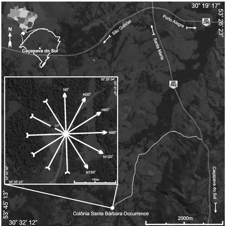
The study area is located at 12 km from the city of Cac¸apava do Sul, distant 259 km from the capital city of Porto Alegre, ap-proximately 12 km to the SW of the intersection of highways BR 290 and BR 392 in Rio Grande do Sul State. The coordinates of the center of the study area are 30◦2501700S and 53◦3105700W,
where the arrangement for the geophysical data acquisition was centered (Fig. 1).
Cac¸apava do Sul region is historically known for its mining activities, which go back to the XIX century, mainly for copper and gold, up to the 1990-decade (Ronchi & Lobato, 2000). During this period a significant decrease of metal prices occurred in the international market, causing the interruption of various mines, including, among others, the Camaqu˜a Mine, which extracted copper for over 70 years. Presently the mining activities in the county are restricted to the extraction of limestone.
The copper occurrence within the study area was named Colˆonia Santa B´arbara, and was prospected by the Brazilian Geo-logical Survey (DNPM) (Bocchi, 1965). The prospection works were initiated with the opening of three trenches, with sampling at each meter, for ten meters. Copper content was lesser than 1% for the richest sample analyzed cores, from one well drilled with a 60◦dip in the direction N◦120, revealed the presence of
chloritic zones and sulfide levels with pyrite (Fig. 2).
The mineralization indicative minerals are barite, quartz and calcite in joints and in the brecciated zone and siderite at the sur-face. However, the concentration of copper is minimal (Bocchi, 1965). The visible copper on surface, possibly resulted from a supergene concentration, with surficial minerals represented by malachite and secondary chalcosite in horizontal levels, in the upper soil horizons.
GEOLOGY
The study region is inserted in the Camaqu˜a Basin, located over the Sul-Rio-Grandense Shield, including sedimentary units from 450-620 My (Paim et al., 2000). This basin evolved as a su-perposition of different basins individualized by its tectonics, geochronology and thermodynamic. Its evolution is related to the final phases of the tectonics of the Brazilian Orogeny (Chemale Jr., 2000; Paim et al., 2000).
Large sedimentary rates and subsidence characterizes the basin, with thick sedimentary and volcanoclastic packages in-tercalated by distinct erosional intervals. The siliciclastic inter-vals are intercalated by large volcanic layers, mainly at the base of the higher hierarchy units. The basin is strongly affected by
“main” — 2012/8/30 — 16:58 — page 171 — #3
MOREIRA CA, LOPES SM, SCHWEIG C & SEIXAS AR
171
Figure 1 – Location of the study area, with the acquisition lines arrangement and the position and dip information of the well.
deformation events generating a complex filling pattern (Kaz-mierczak, 2006).
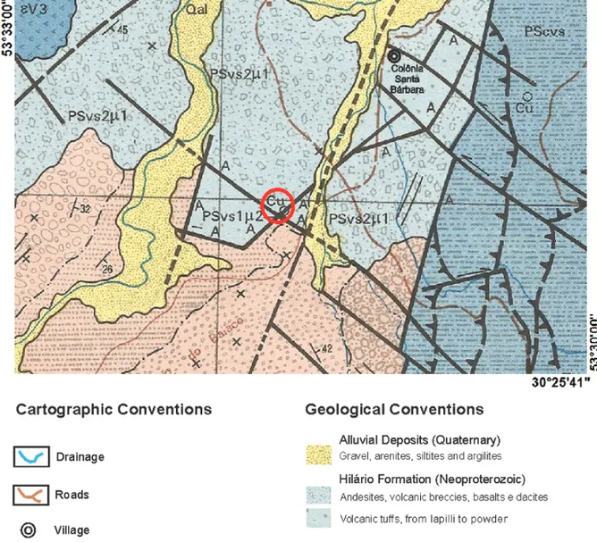
Lithotypes belonging to the Vacaca´ı Metamorphic Complex and volcanic and volcanoclastic sequences from the Bom Jardim Group, represented by the Hil´ario Formation are recognized in the study area (Fig. 3).
The Vacaca´ıMetamorphic Complex incorporates the volcano-sedimentary and the meta-volcanic units, and constitutes the basement of this sedimentary basin. The regional metamorphism which affected the rocks of this association is of low degree, hav-ing rocks with a higher metamorphic degree only in the vicini-ties of granite intrusions, where a mineral paragenesis occurs with cornubianite hornblende facies (Ribeiro, 1970). A regional
meta-morphism zoning was defined for the whole basin, which varies from the chlorite zone, widely dominant, to the staurolite zone (Ribeiro & Fantinel, 1978).
The meta-volcano-sedimentary unit is mainly constituted by pelitic rocks with subordinated occurrences of thin sand lay-ers and eventual ortho-derivated rocks (Porcher, 1995). The meta-pelitic rocks present dark grey and greenish grey colors, with alternations of light and dark millimeter bands. The meta-volcanic rocks are predominantly tuffaceous rocks and, sub-ordinated volcanics, to which epiclastic lithologies are associ-ated. The meta-volcano-clastic lithotypes, are classified as tuffs, lapilli tuffs, powder tuffs, flows and epiclastic deposits, based on the grain size of the fragments.
Figure 2 – Well description (Schweig, 2010).
The Bom Jardim Group represents a volcanic event covering the siliciclastic rocks of the Maric´a Group. The Hil´ario Forma-tion belongs to this group and includes an extensive andesitic volcanism with flows, tuffs and breccia, volcanic conglomerates, mudflows, greywackes, dikes, intrusive maffic rocks and locally, dacitic rocks on the top of the sequence (Porcher & Lopes, 2000). This formation groups all deposits of volcanic nature, including flows, sub-volcanic rocks or volcano-clastics, either of pyroclas-tic nature or epiclaspyroclas-tics related to the neo-proterozoic (∼592 My), intermediate to basic magmatism with shoshonitic affinity (Nardi & Lima, 1985).
The andesites occur as flows and dikes, with dark grey to greenish grey colors, eventually dark red or reddish, porphyritic, with feldspar phenocrysts, hornblende and locally fine barite, malachite and carbonate veins. The basalt flows or dikes are dark grey and black, showing porphyritic texture with pyroxene and plagioclase phenocrysts immersed in a fine-grained matrix (Porcher, 1995).
Meta-conglomerates and localized reddish conglomeratic sandstones are the lithotypes representing the metamorphic com-plex. The conglomerate clasts are rounded quartz pebbles and granitic rocks.
The volcanic lithotypes from Hil´ario Formation are repres-ented by exposures of volcanic tuffs, presrepres-ented as rounded frag-ments within a volcanic ash fine matrix (Porcher, 1995). Strongly fractured andesites also occur, being rich in quartz, carbonates and barite veins. Greenish spots of malachite occur in both litho-types.
Local geophysical and structural analyses (Schweig, 2010) suggest that the mineralization has a strong structural control, oc-curring at the intersection of orthogonal fault planes, with direc-tions N50◦and N150◦. The structural control is also suggested
by the volcanic tuff and andesitic fault blocks elevated, in relation to the meta-conglomerate.
MATERIALS AND METHODS
Electrical resistivity and induced polarization methods were used to measure the electrical resistivity and the chargeability. The theoretical principles of these methods, physical properties of the geologic materials pertinent to the methods, as well as the physical phenomena involved, are detailed by Orellana (1972); Sumner (1976) and Telford et al. (1990).
This work used a Wenner-Schlumberger arrangement with electrodes spacing of 15 m. The electrical resistivity and
charge-“main” — 2012/8/30 — 16:58 — page 173 — #5
MOREIRA CA, LOPES SM, SCHWEIG C & SEIXAS AR
173
Figure 3 – Geologic map of the study area (Adapted from Porcher, 1995).
ability readings were recorded for 10 depth levels along 6 electric survey lines measuring 380 m length each, adding to a total of 2,880 m of acquisition. The lines were arranged in an azimuth form, with the central point fixed over the mineral occurrence, and an angular interval of 30◦(Fig. 1).
A Syscal Pro resistivity meter was used, with 250 W power, maximum transmission current of 2.5 A and resolution of 1μV, allowing chargeability readings in mV/V. This equipment is
cal-ibrated for resistivity and chargeability readings by means of periodic cycles of alternate low frequency electric current which allows to filter the noises of the acquired signal. The following calibration parameters for chargeability readings were applied: tension of 400 V, reading period of 2,000 ms and reading win-dow of 80 ms.
The data were processed with the RES2DINV software (Loke & Barker, 1996), and visualized as electrical resistivity sections.
The inversion process consists in a series of rectangular blocks, in which the disposition of the blocks is connected to the distribu-tion of the field points in the pseudosecdistribu-tion, which is the secdistribu-tion generated by the field data in theoretical depth. The depth of the lower line of the blocks is defined to be approximately equal to the equivalent investigation depth of the points with greatest space among electrodes (Edwards, 1977).
The direct modeling sub-routine is used to calculate the apparent resistivity values, and a minimum squares non-linear optimization technique is used for the inversion routine (DeGroot-Hedlin & Constable, 1990; Loke & Barker, 1996). The result is presented as a distance versus depth sections for the pseudo-section condition, calculated pseudo-section and inversion model. Only the inversion models, related to resistivity and chargeability are presented in this work.
The 3D visualization model was generated from previously 2D modeled data, using the Oasis montaj program developed by Geosoft.
This work adopts the method of minimum curvature for data interpolation. The interpolation consists in a mathematical pro-cess of adjustment of a function for points not-sampled, based in values obtained in sampled points. Using the sampled points a network is defined with a spacing related to the points. The value of each network node is calculated through the selection of the nearest known points, which are later filtered in order to soften the resulting contours and allow a better adjustment with the original values.
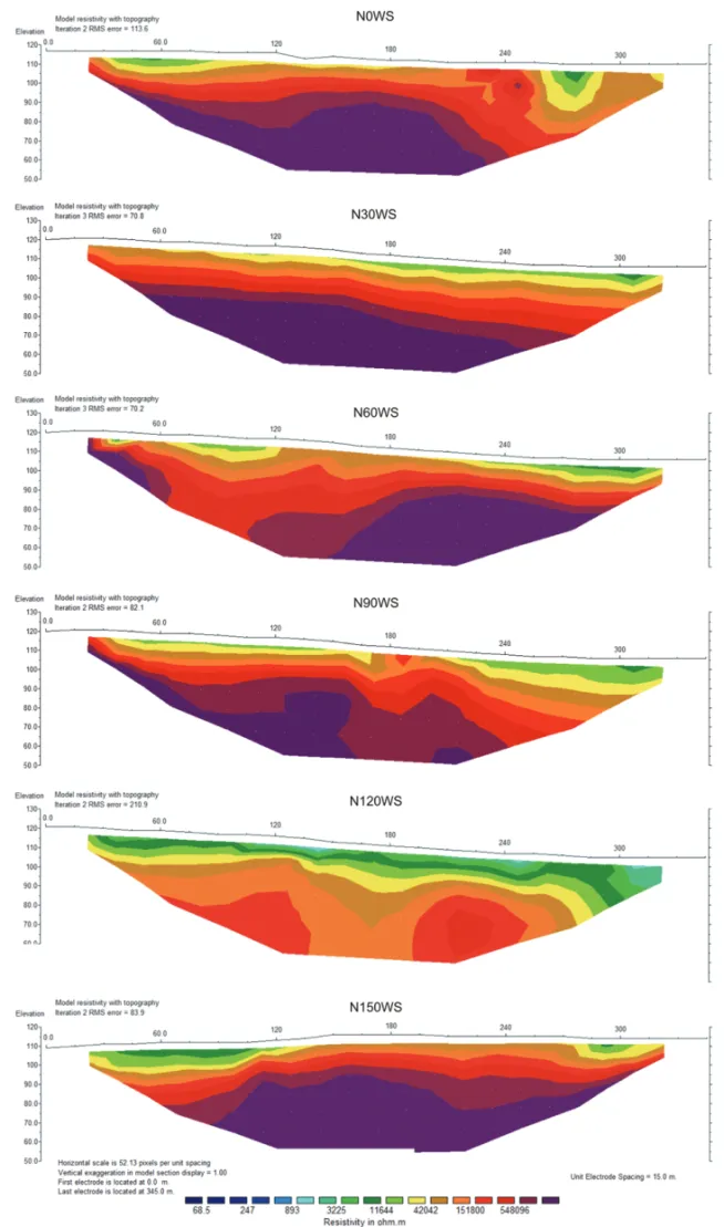
PRESENTATION OF THE RESULTS
The results are presented as resistivity and chargeability inversion models (Figs. 4 and 5). Since there was no significant reduction of the root mean square error (RMS) for models generated with more than 3 inversions, this number was adopted as the process-ing limit for both measured physical parameters.
The large variation of the resistivity values obtained in the inversion models basically reflects the range of measure-ments obtained in the field, in its majority obtained over meta-conglomerates predominantly quartzoze. Although the scale of resistivity presents an ample variation between the minimum and maximum values, its adoption was based on the possibility to enhance the features pertaining to the discussion, interpretation and understanding of the geologic conditions associated to the mineral occurrence studied.
The inversion models present a relatively high RMS error, mainly in the N120WS section, being this fact attributed to the
contrast between maximum and minimum values of the program input data.
The sections with a relatively low RMS error are characterized by plane-parallel horizons with resistivity increasing with depth. The section N120WS is the only exception to this pattern, charac-terized by the average of the lowest values and by low resistivity values at depth in the central portion. This abrupt lateral variation of values, from the center to the borders of the section, possibly contributed for an increase of the RMS error in this case.
The resistivity values along line N0◦varies from 3225 .m
near the surface, up to 548096 .m at 25 m depth. Between 260 m and 360 m occurs a local low resistivity zone, with mini-mum values of 11644 .m from the surface down to 20 m depth. The line N30◦presents resistivity values from 11644 .m near
the surface, up to 548096 .m below 30 m depth. The continu-ous increase in resistivity with depth indicates the presence of soil at surface, over non-weathered rock at depth (Fig. 4).
The line N60◦presents moderate to high resistivity values,
from 11644 .m to 151800 .m along the first 30 m of investi-gation at surface. In general, the resistivity increases with depth, from 11644 .m to 548096 .m. Nevertheless, there is an inter-val between 60 m and 110 m with a substantially lower resistivity with increasing depths, which apparently defines a low resistivity window (Fig. 4).
The line N90◦ presents resistivity values from moderate to
high, which vary from 11644 .m to 548096 .m along the line. The increase of resistivity with depth is also observed (Fig. 4).
The line N120◦presents horizontal layers up to
approxim-ately 30 m depth, with resistivity increase with depth and values between 3225 .m and 508096 .m. The interval between 140 m and 200 m presents maximum values at depth of around 151800 .m. The well adopted for the correlation with the geo-physical data, was drilled near the position 160 m of this line (Fig. 2).
The line N150◦ presents horizontal resistivity layers, with
values which increase gradually with depth, varying from 3225 .m to 548096 .m (Fig. 4).
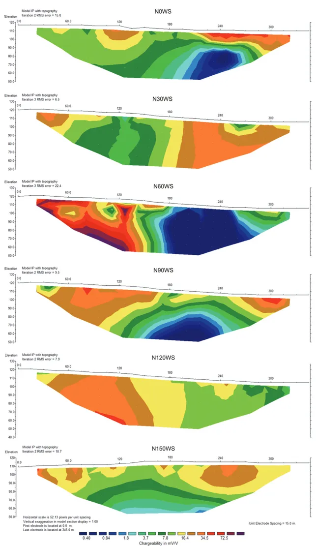
The chargeability model for line N0◦ presents a great
con-trast between the initial portion, with values between 3.7 mV/V and 16 mV/V, and the final portion, with values between 3.7 mV/V and 0.40 mV/V. The low resistivity interval described at the end of this section is characterized by high chargeability values (Fig. 5). The chargeability model presents median slightly variable values in almost the entire line N30◦, between 7.8 mV/V and
34.5 mV. Between 60 m and 195 m predominate values between 3.7 mV/V and 16 mV/V, followed by values between 16 mV/V
“main” — 2012/8/30 — 16:58 — page 175 — #7
MOREIRA CA, LOPES SM, SCHWEIG C & SEIXAS AR
175
“main” — 2012/8/30 — 16:58 — page 177 — #9
MOREIRA CA, LOPES SM, SCHWEIG C & SEIXAS AR
177
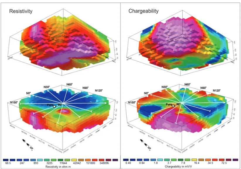
Figure 6 – 3D resistivity and chargeability models, with an angle of view towards N40◦, upper and lower view perspectives and location of the drilled well with dip and angle information.
and 34 mV/V, between 0 m and 60 m and between 195 m and 345 m. The interval between 120 m and 135 m presents a ver-tical strip of low chargeability, apparently not related with resis-tivity variations. It was possible to verify in the field that this line crosses volcanic tuffs between 0 m and 165 m, followed by meta-conglomerates to the end (Fig. 5).
A large contrast of chargeability values occur on line N60◦,
varying from 0.4 mV/V to 72.5 mV/V. From 0 m to 160 m pre-dominate values around 25 mV/V, with the format of an inverted triangle. The interval between 160 m and the end of the section is marked by low chargeability values at depth (Fig. 5).
The chargeability values for line N120◦decrease with depth,
from approximately 16.4 mV/V in the surface to 1.8 mV/V at the base of the section. The chargeability values for line N150◦also
decrease with depth, from approximately 16.4 mV/V on the sur-face to extremely low chargeability values, around 1.8 mV/V, at the base of the section (Fig. 5).
The modeled data for each line were georeferenced and gathered in only one spreadsheet for the generation of
three-dimensional models, presented in color scales, where the high values are presented in hot colors (pink shades), while the low values are presented in cold colors (blue shades). The scale of values is the same adopted for the inversion models (Fig. 6). The 3D blocks present an angle of view near to N40◦, rotated for an
aerial perspective view and for subsurface (Fig. 6).
The 3D visualization model presents high chargeability values between the N30◦ and N90◦ azimuths, with maxima
around 72.5 mV/V, predominantly at the beginning of lines N30◦, N60◦ and N90◦, in the SW portion of the study area
(Fig. 1).
This angle of vision clearly reveals low resistivity values in the extreme SW of the block, in the same area of occurrence of high chargeability values. But, the low resistivity area is less en-compassing, with low contrast values when compared with the chargeability area.
This probably occurs due to the extremely high resistiv-ity values predominant in the area of volcanic tuff, around 550,000 .m. The presence of disseminate sulfides
proportion-ate a small decrease of the resistivity, sufficient enough to pro-duce a contrast with the surrounding rock.
The perspective view from subsurface indicates high resistiv-ity values along the whole base of the 3D block, correlating with low chargeability areas, which indicates the probable absence of mineralization beyond the volcanic tuff area, or otherwise, in the domain of a meta-conglomerate.
This region with high chargeability and low resistivity values is represented in the field by powder tuffs and lapilli tuffs which constitute the more elevated portions of the terrain, where field descriptions indicate impregnations of copper carbonates, such as malachite and azurite.
The data reveal a contrast of values between the main litho-types of the area: low chargeability values for meta-conglomerates and andesites and high values for the volcanic tuffs. The low resistivity values at the surface reflect in large, the presence of sands partially or totally saturated, which gradually increase their thickness towards the NE.
CONCLUSIONS
The combined use of electrical resistivity and induced polariza-tion geophysical methods, integrated with the geologic descrip-tions at surface and of drill cores, improved the knowledge of the mineral occurrence.
The Wenner-Schlumberger arrangement presented satisfac-tory results permitting to correlate the physical parameters of chargeability and resistivity, with the main lithotypes and miner-alization present in the area. The radial layout of the survey lines allowed the generation of 3D models, and the integrated analysis of the measured physical parameter in various positions, besides the visualization of the lateral continuity of the mineralization.
The location of the mineral occurrences at the intersection of fault systems, suggests a structural control. Nevertheless, the predominance of elevated chargeability values and low resistiv-ity values in the area of the volcanic tuffs indicate the presence of disseminated sulfides.
The fault system served probably as a preferred way for the hydrothermal fluids flow, in accordance with similar mineraliza-tion in the Camaqu˜a Sedimentary Basin. The main genetic hypo-thesis for the copper mineralization in this basin area hydrother-mal vein of magmatic origin, a porphyry copper type deposit or asyngenetic sedimentary model (Bettencourt, 1972; Santos & Chaban, 1978; Licht, 1980; Altamirano, 1981; Beckel, 1990; Costa Filho, 1994).
In the case of the mineral occurrence studied, the access of fluids to high porosity lithotypes and the favorable
condi-tions for cementation, possibly allowed the crystallization of dis-seminated sulfides in volcanic tuffs. The andesite and the meta-conglomerate are rocks with very low porosity, which proba-bly made impossible disseminated mineralization, except filling fractures.
The well description indicates levels of pyrite disseminated in fractures and pores and, chloritization, indicating a hydrothermal vein type mineralization, within a structurally controlled area with mineralization in fractures.
Metallogenic studies in the Camaqu˜a Sedimentary Basin, dur-ing the last 40 years, suggest the alternative genesis of a dissem-inated copper type deposit. This hypothesis justified new geo-physical programs, that resulted in the suggestion of a substan-tially larger mineralized area, indicating the potential for new con-firmatory investigations.
REFERENCES
ALTAMIRANO JAF. 1981. Contribuic¸˜ao `a gˆenese das ocorrˆencias cupr´ı-feras estratiformes do Cerro dos Martins, RS. Porto Alegre, Master dis-sertation on Geosciences, Instituto de Geociˆencias, Universidade Federal do Rio Grande do Sul. 172 pp.
BECKEL J. 1990. Metalogen´ıa del Cu, Pb y Zn en la Cuenca de Ca-maqu˜a durante el Ciclo Orog´enico Brasiliano-R´ıo Grande del Sur (Brasil). Barcelona, Doctorate thesis on Geosciences, Universidade de Sala-manca. 275 pp.
BETTENCOURT JS. 1972. A Mina de cobre de Camaqu˜a, Rio Grande do Sul. Porto Alegre, Doctorate thesis on Geosciences, Instituto de Geociˆencias, Universidade Federal do Rio Grande do Sul. 342 pp. BOCCHI PR. 1965. Relat´orio da Ocorrˆencia Cupr´ıfera de Colˆonia de Santa B´arbara. Brasil. Rio de Janeiro: DNPM, Divis˜ao de Fomento da Produc¸˜ao Mineral. 76 pp.
BORBA AW. 2006. Evoluc¸˜ao Geol´ogica da “Bacia do Camaqu˜a” (Neo-proteroz´oico e Paleoz´oico inferior do Escudo Sul-Rio-Grandense, RS, Brasil): uma vis˜ao com base na integrac¸˜ao de ferramentas de estrati-grafia, petrografia e geologia isot´opica. Porto Alegre, Doctorate thesis on Geosciences, Instituto de Geociˆencias, Universidade Federal do Rio Grande do Sul. 121 pp.
CHEMALE Jr F. 2000. Evoluc¸˜ao geol´ogica do escudo Sul-Rio-Gran-dense. In: HOLZ M & DE ROS LF (Eds.). Geologia do Rio Grande do Sul. Porto Alegre, Editora UFGRS. 522 pp.
COSTA FILHO JH. 1994. Prospecc¸˜ao das minas de cobre de Camaqu˜a, Rio Grande do Sul. DNPM. Minist´erio da Agricultura. Boletim, 59: 13– 94.
DEGROOT-HEDLIN C & CONSTABLE S. 1990. Occam’s inversion to generate smooth, two-dimensional models form magnetotelluric data. Geophysics, 55: 1613–1624.
“main” — 2012/8/30 — 16:58 — page 179 — #11
MOREIRA CA, LOPES SM, SCHWEIG C & SEIXAS AR
179
EDWARDS LS. 1977. A modified pseudosection for resistivity and in-duced polarization. Geophysics, 42: 1020–1036.
KAZMIERCZAK TS. 2006. Mapeamento da Bacia do Camaqu˜a com a utilizac¸˜ao de dados geof´ısicos, geologia e sensoriamento remoto. Porto Alegre, Master dissertation on Geosciences, Instituto de Geociˆencias, Universidade Federal do Rio Grande do Sul. 110 pp.
LICHT OAB. 1980. A descoberta da Jazida Santa Maria (Zn, Cu, Pb), Rio Grande do Sul – um caso hist´orico de prospecc¸˜ao geoqu´ımica. In: Simp´osio Brasileiro de Geoqu´ımica, 1: 1980, Cambori´u, Proceedings... Cambori´u: SBGq, v. 1. p. 141.
LOKE MH & BARKER RD. 1996. Rapid least-squares inversion of appar-ent resistivity pseudosections by a quasi-Newton method. Geophysical Prospecting, 44: 131–152.
MARANH˜AO RJL. 1985. Introduc¸˜ao `a Pesquisa Mineral. Banco do Nor-deste do Brasil, Fortaleza, 2nded., 796 pp.
NARDI LVS & LIMA EF. 1985. A Associac¸˜ao Shoshon´ıtica de Lavras do Sul, RS. Revista Brasileira de Geociˆencias, 15(2): 139–146.
ORELLANA E. 1972. Prospecci´on Geoel´ectrica en Corriente Continua. Paraninfo, Madri. 523 pp.
PAIM PSG, CHEMALE Jr F & LOPES RC. 2000. A Bacia do Camaqu˜a. In: HOLZ M & DE ROS LF (Eds.). Geologia do Rio Grande do Sul. Porto Alegre, Editora UFGRS. 522 pp.
PEREIRA RM. 2003. Fundamentos de Prospecc¸˜ao Mineral. Editora Interciˆencia. 167 pp.
PETERS WC. 1978. Exploration and Mining Geology. John Wiley & Sons, New York. 696 pp.
PORCHER CA. 1995. Programa Levantamentos Geol´ogicos B´asicos do Brasil. Folha Passo do Salsinho, Folha SH.22-Y-A-I-4. Estado do Rio Grande do Sul. Escala 1:50.000. Bras´ılia, CPRM. 358 pp.
PORCHER CA & LOPES RC. 2000. Programa Levantamentos Geol´ogicos B´asicos do Brasil. Folha Cachoeira, Folha SH.22-Y-A. Estado do Rio Grande do Sul. Escala 1:250.000. Bras´ılia, CPRM. 117 pp.
RIBEIRO M. 1970. Geologia da Folha de Bom Jardim, Rio Grande do Sul, Brasil. Rio de Janeiro: DNPM, Boletim 2.
RIBEIRO M & FANTINEL LMA. 1978. Associac¸˜oes Petrotectˆonicas do Escudo Sul-Rio-Grandense. I – tabulac¸˜ao e distribuic¸˜ao das associa-c¸˜oes petrotectˆonicas do escudo do Rio Grande do Sul. Iheringia, S´erie Geol´ogica, v. 5, p. 19–54.
RONCHI LH & LOBATO AOC. 2000. Minas do Camaqu˜a, um estudo mul-tidisciplinar. S˜ao Leopoldo: Unisinos. 366 pp.
SANTOS JF & CHABAN N. 1978. Concentrac¸˜oes de cobre sedimentar do tipo red-bed em Cac¸apava do Sul (RS). In: Congresso Brasileiro de Geologia, 30: 1978, Proceedings... Recife: SBG, v. 6, p. 2562–2575. SCHWEIG C. 2010. Caracterizac¸˜ao geoel´etrica da ocorrˆencia de Cobre Colˆonia de Santa B´arbara, Munic´ıpio de Cac¸apava do Sul (RS). Cac¸apava do Sul, Monograph (Graduate in Geophysics), Universidade Federal do Pampa. 77 pp.
SUMNER JS. 1976. Principles of induced polarization for geophysical exploration. Amsterdam, Elsevier Scientific. 277 pp.
TELFORD WM, GELDART LP & SHERIFF RE. 1990. Applied Geophysics. 2nded., Cambridge University Press, New York. 774 pp.
NOTES ABOUT THE AUTHORS
C´esar Augusto Moreira. Bachelor in Geology at Universidade Estadual Paulista – UNESP/Rio Claro-SP (2003). Worked as mining geologist at the S˜ao Francisco
Mine (Serra da Borda Minerac¸˜ao e Metalurgia – SBMM – Yamana Gold). Doctor in Geosciences at Universidade Estadual Paulista – UNESP/Rio Claro-SP (2009). Associate professor in undergraduate courses of Geophysics and Geology at the Universidade Federal do Pampa – UNIPAMPA/Cac¸apava do Sul-RS (2009-2011). Presently assistant professor at the Department of Applied Geology, Universidade Estadual Paulista – UNESP/Rio Claro-SP. Areas of activity: applied geophysics, mineral research, hydrogeology and environmental studies.
Syngra Machado Lopes. Bachelor in Geophysics at Universidade Federal do Pampa – UNIPAMPA/Cac¸apava do Sul-RS. M.Sc. graduate student in Geosciences,
with emphasis in Regional Geology, at Universidade Estadual Paulista – UNESP/Rio Claro-SP. Areas of interest: Mineral geophysical prospecting.
Camila Schweig. Bachelor in Geophysics at Universidade Federal do Pampa – UNIPAMPA/Cac¸apava do Sul-RS. M.Sc. graduate student in Geosciences, with
emphasis on Regional Geology, at Universidade Estadual Paulista – UNESP/Rio Claro-SP. Areas of interest: geophysical characterization of sedimentary basins.
Adriano da Rosa Seixas. Bachelor in Geophysics at Universidade Federal do Pampa – UNIPAMPA/Cac¸apava do Sul-RS. M.Sc. graduate student in Geosciences,