Maria Luisa Correia Chaves
D
OUTORAMENTO EMB
IOLOGIA(Ecologia)
U
NIVERSIDADE DEL
ISBOAF
ACULDADE DEC
IÊNCIASD
EPARTAMENTO DEB
IOLOGIAA
NIMALSpatio-temporal dynamics of undisturbed macroinvertebrate
communities in the Mondego River basin
-
Contribution to the ecological assessment of streams
Tese orientada por:
Professora Catedrática Maria José Costa
Professor Catedràtic Narcís Prat i Fornells
U
NIVERSIDADE DEL
ISBOAF
ACULDADE DEC
IÊNCIASD
EPARTAMENTO DEB
IOLOGIAA
NIMALSpatio-temporal dynamics of undisturbed macroinvertebrate
communities in the Mondego River basin
-
Contribution to the ecological assessment of streams
Maria Luisa Correia Chaves
D
OUTORAMENTO EMB
IOLOGIA(Ecologia)
This dissertation should be cited as:
Chaves, M.L. (2008) Spatio-temporal dynamics of undisturbed macroinvertebrate communities in the
Mondego River basin - Contribution to the ecological assessment of streams. PhD Thesis, Universidade
Aos meus pais e filho
"Man is defined not by what he creates, but by what he chooses not to destroy."
Agradecimentos
Acknowledgments
To all the people that have contributed to this work in so many different ways I hereby express my sincere gratitude. I am especially thankful to my friends and family, who always encouraged and stood by me in difficult moments but also to my supervisors and colleagues who gave me the scientific knowledge to perform this task. It is more than fair to particularly acknowledge some of them here:
A todas as pessoas que me ajudaram na realização deste trabalho aqui deixo o meu mais sincero agradecimento. Estou particularmente grata aos meus amigos e família que sempre me encorajaram e me apoiaram nos momentos mais difíceis mas também aos meus orientadores e colegas que em muito contribuíram para a minha formação e para o desenvolvimento deste trabalho. É mais do que justo salientar alguns deles aqui:
À Professora Maria José Costa por ter confiado nas minhas capacidades ao me aceitar como sua aluna de doutoramento, pelo seu constante interesse no desenvolvimento deste trabalho, mas principalmente por ter aberto a porta do seu laboratório aos macroinvertebrados de água doce.
Al professor Narcís Prat per la seva valuosa contribució científica a aquest treball, per haver-me ensenyat tot el que conec dels quironòmids i per, malgrat la distància, haver-me recolzat sempre tant professionalment com personalment.
Ao Lino Costa, por ter feito com que este trabalho exista. Sem as nossas preciosas discussões científicas e sem a tua amizade este estudo seria metade do que é. Muito obrigada pela constante e desinteressada ajuda.
À Paula Chainho, pela presença em todas as fases deste trabalho sem excepção, pelo produtivo “co-autorismo” e empenhada revisão dos artigos, pelas incontáveis sugestões, mas especialmente pelo companheirismo e forte amizade que se criou ao longo destes anos e que agora nos une.
Ao Henrique Cabral, por estar sempre disponível e por simpaticamente me ter acolhido no seu laboratório durante alguns anos.
d'alguns grups específics de quironòmids i per la redacció i revisió conjunta d'alguns dels treballs derivats d'aquesta tesi.
To Charles Paxton, Mike Lane and Monique MacKenzie for providing very useful data analysis comments and critics and for writing the R code used in this thesis.
A todos os meus colegas de equipa do instituto de Oceanografia, Cármen, Carla Azeda, Carlos Assis, Catarina, Catarina Vinagre, Célia, João Calado, João Paulo, João Salgado, José Jacinto, José Loff, Manuel Cabral, Manuel Horta, Pedro Raposo, Rita, Susana, Sílvia, Tadeu e Teresa Lopes, pelo bom e divertido ambiente de trabalho que me proporcionaram ao longo destes anos, e em especial ao Bernardo, Joana e Sérgio Rodrigues pela adicional ajuda no trabalho de campo.
À Carla Barrinha, Maria Albino, Elsa e Isabel Domingos pelo auxílio em tarefas laboratoriais, burocráticas ou situações que não conseguiria resolver sozinha.
Ao Nuno Prista, companheiro de gabinete, pelas inúmeras conversas e por partilhares e compreenderes tão bem as minhas dificuldades e objectivos.
A mis compañeros del laboratorio Freshwater Ecology and Management, Cesc, Carolina, Toni, Mireia, Rosa, Miguel, Laura, Núria, Pau, Raul, Iraima por haberme ayudado científica y personalmente durante mis estadías en la Universidad de Barcelona y por la magnífica convivencia.
A la Tura per haver-me ajudat a sobreviure lluny de casa i per haver compartit amb mi el seu coneixement sobre els quironòmids. Espero que la nostra amistat perduri més enllà d'aquest doctorat.
A Blanca por los divertidos momentos que pasamos juntas y por la constante ayuda mientras estaba lejos.
A todos mis amigos que me recibieron en sus casa durante mis visitas a Barcelona, transformando el tiempo lejos de casa en un excelente período, en particular a Mireia, Rosa Andreu, Malicha, Blanca, Veronica, Yolanda, Alicia, Sandrita e Tura. Verito, estaré siempre en deuda.
Aos colegas das equipas da física e da botânica do IO, Carolina, Obadias, João, Alberto, Jorge, Sérgio e André pelo privilégio de poder partilhar com vocês a sala de escrita.
À amiga Gilda, pela preciosa ajuda na submissão electrónica dos artigos e formatação e revisão da tese, por seres crítica e rezingona nas alturas certas e calma em momentos de tensão.
Acknowledgments/ Agradecimentos
À Luzia Borges, pelo apoio constante e imprescindível ao longo destes anos e por te interessares sempre.
À Ana Luísa pela companhia durante o trabalho de campo, por solucionar inúmeras questões laboratoriais e pela amizade.
Aos amigos Cláudia, Luís da Costa, Luís, Luísa Branquinho, Luísa Camacho, Maria Carlos, Marta, Monya, Nuno, Patrícia Tiago, Patrícia Salgueiro, Sónia, Teresa e descendências, pelos alentos, estímulos, diversões e amizade.
Ao Filipe Ribeiro, pelas conversas de trabalho, pelos inúmeros momentos de lazer e pela companhia nalgumas das fases mais cruciais deste período.
À minha família mais próxima: irmãos, cunhada, sobrinhos e avó Gabriela. Sem vocês isto não teria sido possível.
Aos meus pais, a quem estou particularmente grata e a quem dedico este trabalho e espero vir dedicar outros ainda mais importantes, pois foram vocês que me permitiram chegar onde estou hoje e me ajudam continuamente, sem exigências algumas.
Ao Tiago e ao Filipe, os meus dois rapazes, pelos ensinamentos, ajudas e amor mas fundamentalmente por tão simples e claramente definirem as minhas prioridades na vida, vocês.
Agradecimentos institucionais:
Ao Instituto de Oceanografia da FCUL e ao Freshwater Ecology and Management Group da UB por terem acolhido este doutoramento e os projectos no âmbito dos quais foi desenvolvido.
À Fundação para a Ciência e Tecnologia e ao ESF no âmbito do III Quadro Comunitário de Apoio pela a atribuição da bolsa individual SFRH/BD/6365/2001.
Ao Instituto do Ambiente pelo apoio financeiro através do projecto QUERE.
Ao INAG, em especial à Eng. Helena Alves e ao Dr. João Pádua, pela cedência de material diverso relativo à Bacia Hidrográfica do Mondego.
Resumo
As alterações ambientais que afectam os sistemas ribeirinhos têm vindo a aumentar, desde os efeitos provocados pela descarga de efluentes domésticos, até às alterações climáticas, passando pelas modificações decorrentes de invasões de espécies exóticas e da intensa utilização humana dos rios e ribeiros e das suas áreas de drenagem. Em Portugal, e de um modo geral em todo o Mundo, a capacidade humana para preservar, reabilitar e gerir os sistemas aquáticos está parcialmente limitada pela falta de interesse/conhecimento público e consequente fraca vontade politica, mas também pelo inadequado e/ou incompleto conhecimento científico de base sobre estes sistemas. A obtenção de informação científica sobre a biodiversidade dulciaquícola em condições naturais (não alteradas pelo Homem) e a sua subsequente disponibilização permitirão, entre outros aspectos, avaliar:
1] O tipo e nível de impacte que as actividades humanas têm sobre os sistemas ribeirinhos. A aprovação da Directiva Quadro da Água (DQA) em 2000, que estabelece um quadro de acção comunitária no domínio da política da água, representou um marco importante [a] ao introduzir os conceitos de estado ecológico e monitorização biológica na legislação europeia, definindo a fauna piscícola, os invertebrados bentónicos e a flora aquática como elementos de qualidade para a avaliação do estado ecológico dos rios Portugueses e [b] ao legalmente estabelecer que a biomonitorização deveria ser expressa em rácios de qualidade ecológica, sendo que estes representarão a relação entre os valores dos parâmetros biológicos observados para uma dada massa de águas de superfície e os valores desses parâmetros nas condições de referência aplicáveis a essa mesma massa de água. A actividade humana degrada a integridade biológica modificando, destruindo ou contaminando os elementos que suportam e mantêm as comunidades bióticas e consequentemente causando o seu desvio em relação ao estado natural. Torna-se essencial distinguir perturbações humanas de variações naturais.
2] O modo como as comunidades ribeirinhas serão potencialmente modificadas pelas alterações climáticas. Em sistemas intensamente intervencionados pelo Homem, os efeitos directos das alterações climáticas podem ser tamponados ou completamente confundidos com outros impactos, tornando-se impossível a sua detecção. Contrariamente, em sistema lóticos naturais os efeitos das alterações climáticas são passíveis de serem identificados.
3] A biodiversidade de sistemas aquáticos pouco estudados. A inexistência de listas faunísticas para muitos sistemas lóticos dificulta a monitorização e o sucesso da reabilitação
estrutural e funcional dos rios e a previsão do impacto das alterações climáticas nos sistemas lóticos.
Tendo em conta este cenário, o presente estudo teve como principal objectivo melhorar o conhecimento sobre a ecologia e taxonomia das comunidades de macroinvertebrados em condições não perturbadas, incidindo particularmente na sua variação espacial e temporal, não apenas devido ao seu interesse intrínseco, mas especialmente porque permite o desenvolvimento, melhoramento e validação de ferramentas para a avaliação do estado ecológico de rios.
A presente tese encontra-se organizada em 6 capítulos, quatro dos quais incluem cinco artigos científicos publicados ou submetidos em revistas científicas internacionais, precedidos de uma introdução geral. As considerações finais são apresentadas no último capítulo.
O Capítulo 1, introdução geral, sumarisa as principais pressões humanas e a evolução dos métodos de monitorização dos sistemas lóticos, a importância do estudo destes sistemas em condições naturais, e a necessidade de simplificar a informação biológica e abiótica dos rios recorrendo a tipologias. Neste capítulo é ainda efectuado um breve enquadramento legal da avaliação de qualidade dos rios e ribeiros focado na DQA e destacando a avaliação ambiental por comparação com condições de referência (reference condition approach). Num sub-capítulo, referem-se as funções e variações espaciais e temporais das comunidades de macroinvertebrados nos sistemas lóticos, identificam-se as características que as tornam boas indicadoras de qualidade ambiental e elabora-se ainda uma revisão sumária dos principais métodos de avaliação de qualidade utizando os invertebrados. Este capítulo inclui uma breve descrição da Bacia Hidrográfica do Mondego (BHM), como área de estudo da presente tese. Finalmente, são apresentados os objectivos gerais e específicos sob a forma de questões.
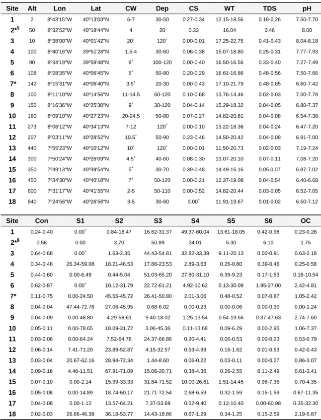
No Capítulo 2, são identificados os gradientes ambientais que estruturam espacial e temporalmente as comunidades não perturbadas de macroinvertebrados da BHM. Neste capítulo são listadas as famílias de macroinvertebrados encontradas nestes troços de rio com mínimas perturbações humanas e é discutida a contribuição regional ou local das variáveis ambientais na estruturação destas comunidades. Esta análise tem como base um conjunto de dados recolhidos em 18 locais da BHM durante 3 sessões de amostragem (ao longo de um ano), de forma a cobrir possíveis variações sazonais. Quatro destes locais estão posicionados em tributários principais do Rio Mondego e os restantes em rios e ribeiros geograficamente dispersos pela BHM, a altitudes e regiões geológicas diversas, e onde foram medidos cerca de 30 parâmetros ambientais por campanha.
Apesar dos locais amostrados cobrirem muita da variabilidade natural da área de interesse e de ter sido feito um esforço para se seleccionarem rios e ribeiros permanentes e temporários nesta fase inicial do trabalho, os primeiros sistemas claramente excederam os
Resumo
segundos. Como o padrão estrutural das comunidades de macroinvertebrados se aproximava mais dos padrões evidenciados pelas comunidades de macroinvertebrados claramente mediterrânicas do que dos encontrados em rios temperados do Norte de Portugal, foi feito um esforço no sentido de se alargar a rede de amostragem para incluir maior número de troços temporários não perturbados e consequentemente tornar a amostragem representativa de um sistema mediterrâneo. Simultaneamente, foi definido um conjunto de critérios indicadores de pressão humana para garantir a relativa naturalidade dos troços escolhidos. No Capítulo 3, descreve-se o procedimento anteriormente referido. Este protocolo para identificação de troços relativamente não perturbados permitiu a consequente identificação dos principais factores a afectarem as comunidades de macroinvertebrados potencialmente não perturbadas e a comparação quantitativa e qualitativa dos locais seleccionados como relativamente não perturbados, ao usarem-se critérios definidos a priori (físicos/sociais/biológicos) para indicação de pressão humana versus uma investigação detalhada no campo sobre a comunidade de macroinvertebrados, a vegetação ripícola, as características dos habitats ribeirinhos e a medição de variáveis químicas da água.
Depois de investigadas quais as variáveis ambientais que estruturam as comunidades de macroinvertebrados da BHM (Capítulo 2) e de se ter um número suficiente de locais relativamente não perturbados representativos de alguns tipos de rios e ribeiros (6 tipos) existentes na BHM (Capítulo 3), foi então possível testar se a tipologia física nacional dos sistemas lóticos fragmentava correctamente a variabilidade natural das comunidades de macroinvertebrados, i.e. se os tipos de rios definidos com base no sistema B da DQA eram biologicamente relevantes. Uma tipologia errada conduz a erros de monitorização e consequentes erros na qualidade avaliada do sistema, já que a variabilidade natural pode ser tomada como degradação humana ou o contrário. Este tema foi estudado no Capítulo 4, tendo-se usado locais relativamente não perturbados, mas não locais de referência sensu DQA, já que a comunidade de macroinvertebrados foi a única testada.
No Capítulo 5, que compreende dois artigos, foram descritas a composição e estrutura da comunidade de macroinvertebrados e analisadas as variações espacio-temporais da mesma em sistemas lóticos intermitentes pertencentes à BHM, localizados na Serra da Estrela a elevada altitude (1400 m acima do nível do mar), e incluindo-se, por isso, num tipo de rio muito pouco frequente em Portugal Continental. Estes ribeiros estão sujeitos a baixa pressão humana, já que são abrangidos pelo Parque Natural da Serra da Estrela. Os invertebrados foram identificados ao nível taxonómico do género/espécie, com especial relevo para a Família Chironomidae. Foi ainda efectuado um estudo comparativo entre três níveis taxonómicos (ordem, família e género) para investigar a influência destes nos resultados. São indicadas breves previsões sobre alterações na biodiversidade dos macroinvertebrados destes sistemas com base num potencial cenário de alterações climáticas para alta montanha, já que os ribeiros
intermitentes de alta montanha estão entre os sistemas mais vulneráveis às alterações climáticas na Europa.
O Capítulo 6 integra os resultados obtidos nos diferentes artigos através de um conjunto de considerações finais e apresenta as principais conclusões da tese, resumidas seguidamente: [1] As comunidades de macroinvertebrados relativamente não perturbadas da BHM variam espacial e temporalmente, sendo reguladas por uma multiplicidade de factores que operam localmente [granulometria do substrato e condições hidráulicas (corrente e oxigénio dissolvido)] e em escalas espaciais mais abrangentes [geologia do leito do rio (inferida pela condutividade), altitude e largura do canal]; [2] A variação sazonal destas comunidades apresenta um padrão estrutural mais próximo dos padrões evidenciados pelas comunidades de macroinvertebrados claramente mediterrânicas do que dos encontrados em rios temperados do Norte de Portugal, onde a sazonalidade não é tão evidente; [3] Para fins de monitorização, a Primavera tardia (ou inicio do Verão) foi identificada como a melhor ocasião de amostragem, no caso de uma amostragem única. Idealmente, a amostragem deveria ser realizada em todas as épocas do ano (e mais do que uma vez em cada época), devido à forte variação sazonal das comunidades de macroinvertebrados da BHM; [4] Critérios pré-definidos de pressão humana e medições no campo de parâmetros abióticos e bióticos identificaram diferentes troços de rio como relativamente naturais e devem, por isso, ser usados em simultâneo; [5] Os tipos físicos de rios e ribeiros existentes na BHM (que haviam sido definidos com base no sistema B da DQA) são biologicamente relevantes. No entanto, a heterogeneidade espacial e temporal das condições abióticas pode dificultar a biomonitorização, já que as variações temporais e a intermitência dos sistemas parecem não estar integradas na tipologia; [6] É esperada uma perda de biodiversidade das comunidades de macroinvertebrados nos rios intermitentes de elevada altitude (Serra da Estrela), de acordo com as previsões de alterações climáticas para alta montanha.
Salienta-se ainda que com este trabalho: [7] Foi desenvolvido e testado um protocolo para identificação de troços de rios e ribeiros relativamente não perturbados; [8] Foram obtidos os primeiros dados consistentes sobre as comunidades de macroinvertebrados de ribeiros intermitentes de elevada altitude, que mostram a Família Chironomidae como dominante em abundância e riqueza genérica e [9] Foram identificadas novas espécies de quironomídeos para Portugal Continental e para a Península Ibérica.
Palavras chave: macroinvertebrados dulciaquícolas, variabilidade natural, Chironomidae, Bacia Hidrográfica do Mondego, Directiva Quadro da Água.
Summary
Macroinvertebrates have become the most commonly used and widely known biological indicators for assessing and monitoring human impacts in streams because they respond predictably to many kinds/intensities of anthropogenic pressures. Hence, they were included in the indicators group of ecological status required by the Water Framework Directive (WFD). However, the lack of understanding about natural spatio-temporal variations of macroinvertebrate communities and the lack of taxa lists for many undisturbed lotic systems most certainly hinder streams condition bioassessment, the successful restoration of the natural structural and functional integrity of an ecosystem, and the prediction of climate change impact on freshwater biodiversity.
Spatio-temporal dynamics of undisturbed macroinvertebrate communities of the Mondego River basin (MRb) were analysed showing a strong variation both spatially and temporally. These variations were regulated through a multiplicity of factors operating at local [substrate type and hydraulic conditions (current speed, dissolved oxygen)] and larger spatial scales [streambed geology (inferred by conductivity), altitude and channel width]. Seasonal variation of these communities was more similar to that in other Mediterranean streams rather than that in northern temperate Portuguese streams, where seasonality is not as evident. Physical stream types of the MRb (based on the WFD system-B national typology) were tested for biological meaning and showed significant relevance for macroinvertebrates. However, spatial and temporal heterogeneity of abiotic conditions might hinder bioassessment since temporal variations and intermittency do not seem to be incorporated in typology results. Particular emphasis was given to high altitude intermittent streams (above 1400 m a.s.l.), where new chironomid species records were found for continental Portugal and the Iberian Peninsula and the loss of macroinvertebrate biodiversity is expected to occur based on climate change predictions. Also, a protocol to help selecting near-natural stream sites was developed and tested. Finally, the present work raised the need for long term studies, for more information concerning intermittent streams, for molecular studies to solve and complement the lack of taxonomical knowledge and for cross-linking reference conditions and climate change.
Key words: freshwater macroinvertebrates, natural variability, Chironomidae, Mondego River basin, Water Framework Directive.
List of papers
This thesis comprises the papers listed below:
CHAVES, M.L., P. CHAINHO, J.L. COSTA, N. PRAT & M.J. COSTA, (2005) Regional and local environmental factors structuring undisturbed benthic macroinvertebrate communities in the Mondego River basin, Portugal. Archive für Hydrobiologie 163: 497-523.
CHAVES, M.L., J.L. COSTA, P. CHAINHO, M.J. COSTA & N. PRAT, (2006) Selection and validation of reference sites in small river basins. Hydrobiologia 573: 133-154.
CHAVES, M.L., J.L. COSTA, P. CHAINHO, M.J. COSTA & N. PRAT, (submitted) Typology schemes as management and assessment tools: Are physical stream types biologically relevant? Environmental Management.
CHAVES, M.L., M. RIERADEVALL, J.L. COSTA, P. CHAINHO, M.J. COSTA & N. PRAT, (2008) Macroinvertebrate communities of non-glacial high altitude intermittent streams. Freshwater Biology 53: 55-76.
RIERADEVALL M., M.L. CHAVES & N. PRAT, (2007) High altitude Chironomidae (Diptera) of Serra da Estrela (Portugal): Additions to the Portuguese and Iberian Peninsula fauna. Graellsia 63: 273-278.
M.L. Chaves, leading author of most of the papers comprised in this thesis, was responsible for sample collection and processing, laboratory procedures and species identifications, as well as data analyses and manuscript writing, submission and revision with exception of paper 5, which was co-written and co-revised by M. Rieradevall and submitted by N. Prat.
Table of contents
Acknowledgments/ Agradecimentos ... i Resumo ... v Summary ... ix List of papers ... xi Chapter 1 General introduction ...3 Chapter 2Regional and local environmental factors structuring undisturbed benthic macroinvertebrate communities in the Mondego River basin,
Portugal ...33 Chapter 3
Selection and validation of reference sites in small river basins ...63 Chapter 4
Typology schemes as management and assessment tools: are
physical stream types biologically relevant? ...97 Chapter 5
5a- Macroinvertebrate communities of non-glacial high altitude
intermittent streams ...131 5b- High altitude Chironomidae (Diptera) of Serra da Estrela
(Portugal): additions to the Portuguese and Iberian Peninsula fauna...169 Chapter 6
Final remarks ...179
Chapter 1
Chapter 1
General introduction
The importance of studying and monitoring running waters
Environmental changes in rivers and streams have increased from sewage discharge in the first decennia of the 20th century towards climate change today (Verdonschot, 2000). Human impacts on the water cycle have consequently reached global amplitude (Meybeck, 2004) and have caused widespread loss of suitable aquatic habitats and species. Successively, physico-chemical, biological and ecological assessment evolved but failed to stop deterioration (Verdonschot, 2000). Human ability to address preservation, restoration and management of running waters is partly limited by lack of public awareness and consequently short political will but also by an inadequate/incomplete knowledge base.
Obtaining sufficient and credible scientific information on freshwater biodiversity and making it available as a basis for action is the very beginning to successfully deal with sustainable management and conservation of the world’s freshwater resources (Balian et al., 2008).
Studies on spatial and temporal dynamics of freshwater biological communities of roughly undisturbed sites with measurements on abiotic characteristics help to [1] assess the level of human-activity impact on running waters, [2] understand how climate change might modify the freshwater communities and [3] determine the actual species richness and biodiversity of some specific stream reaches poorly known until now.
1. Bioassessment and the reference condition approach in running waters
Human activity near and in freshwater ecosystems is increasing on a daily basis, promoting environmental degradation of these systems. Many human activities across the landscape contribute directly or indirectly to this degradation, including discharge of domestic,
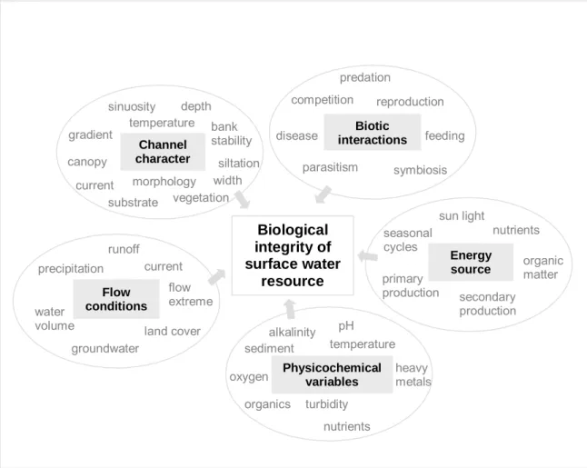
agricultural and industrial effluents (e.g., eutrophication, acidification, lethal and sublethal contamination of biota); straightening, deepening and clearing of stream channels, drainage of wetlands, impoundment of streams, dam operations and water diversions (e.g., erosion, sedimentation, decreased longitudinal connectivity, flow alterations); harvest of biota and introduction of non-native species (e.g., disruption of natural food webs); and groundwater contamination (Allan & Flecker, 1993; Simon & Lyons, 1995; INAG, 2001). Due to the critical role of freshwater to all living systems, impacts have to be evaluated to assess whether or not the stressor has changed the environment, to determine which components are adversely affected, and to estimate the magnitude of the effects on the integrity of rivers and streams (Smith, 2002). Measures of chemical integrity are no longer enough in monitoring programs (European Commission, 2000) since most impacts occur through time (Barbour et al., 2000) and several disturbances are not chemically detectable (physical and biological stressors). The historical dominance of chemical criteria in water quality standards resulted in chronic underreporting of degradation (Davis et al., 1996; U.S. Environmental Protection Agency, 2005). To protect water resources it is necessary to accurately measure the existence of cumulative impacts of multiple stressors through time. Consequently, biological integrity assessment expanded (Figure 1.1). Human-activity degrades biological integrity by modifying, destroying and contaminating elements that support and maintain biological communities (Figure 1.1) and thus causing them to deviate from a natural state. Because biological communities integrate the effects of different stressors, bioassessment [i.e., the use of biological variables to survey the environment according to Bonada et al. (2006a)], together with chemical and morphological evaluations (habitat assessment), has become the more comprehensive and effective monitoring and assessment strategy (Davis & Simon, 1995; Barbour, 1997; Barbour et al., 2000; European Commission, 2000; Gerritsen et al., 2000).
The most effective bioassessment technique with renewed interest and closely related to the biological/ecological integrity concept is the reference condition approach (RCA; sensu Reynoldson et al., 1997). In this approach, the ecological quality of a test site is evaluated based on the deviation of its biological community from a near-natural “reference” condition, with very similar characteristics (e.g., Wright et al., 1984; European Commission, 2000; Wallin et al., 2003; Bailey et al., 2004). Whereas all uses of the term reference condition have at their root some concept of natural or pristine condition, most practitioners recognize that few, if any, truly pristine places still exist in the world (Stoddard, 2005). Hence, the reference condition (RC) is commonly defined as a status representative of a group of undisturbed or minimally disturbed sites, i.e. which were minimally exposed to human stressors (e.g., Bailey et al., 2004), whereas the biological RC is the description of the biological elements that exist under no or very minor human disturbances (Economou, 2002; Wallin et al., 2003; Bailey et al., 2004).
Chapter 1 Biological integrity of surface water resource Channel character siltation substrate bank stability vegetation canopy morphology gradient temperature depth width current sinuosity Physicochemical variables sediment alkalinity temperature organics heavy metals pH oxygen nutrients turbidity Flow conditions current precipitation runoff groundwater land cover water volume flow extreme Biotic interactions disease predation reproduction parasitism competition feeding symbiosis Energy source sun light primary production seasonal cycles organic matter nutrients secondary production
Biological integrity is defined by Karr and Dudley (1981) as the ability to support and maintain a balanced, integrated, adaptive assemblage of organisms having species composition, diversity, and functional organization comparable to that of the natural habitat of the region.
Figure 1.1 - Five main components of surface water resources and some of their factors that might be changed by human action (modified from Karr et al., 1986).
A RC represents information from numerous similar sites (e.g., Reynoldson et al., 1997; Wallin et al., 2003; Bailey et al., 2004), and offers, therefore, a powerful alternative because sites themselves serve as replicates rather than the multiple collections within sites like in traditional designs (Reynoldson et al., 1997). RC will accordingly provide the baseline against which to measure anthropogenic impacts of a test site, describe the biological community potential and define spatial and temporal natural variability (Reynoldson et al., 1997; Economou, 2002; Wallin et al., 2003; Bailey et al., 2004). Bioassessment using the RCA consequently depends on appropriate initial characterization of the RC (Gerritsen et al., 2000), an essential but difficult step in quality evaluation (e.g., De Pauw et al., 2006) due to the inherent variability in both physical habitat and biological elements (Nijboer et al., 2004).
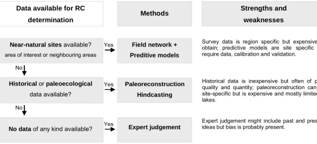
RC can be [1] based on field surveys of near-natural sites (with minor anthropogenic impacts), [2] derived by modelling, [3] based on historical data, [4] derived by paleo-reconstruction, [5] supported by expert judgement or [6] obtained by a combination of some of these methods (e.g., Hughes, 1995; Barbour et al., 1996; Gibson et al., 1996; Economou, 2002; Wallin et al., 2003). Despite the existence of various methods to obtain undisturbed or minimally disturbed biological data and for estimating RC, the most straightforward and by far the most common approach is to investigate the existence of field reference sites and to use other methods only if this kind of information is not available (Wallin et al., 2003; Stoddard, 2005) (Figure 1.2). In relatively undisturbed areas the reference sites may be obtained using clearly defined, a priori, criteria for human-induced disturbance. The remaining sites will consequently exhibit the natural variability of the region, which must nonetheless be validated using field abiotic and/or biotic data (Nijboer et al., 2004).
Near-natural sites available?
area of interest or neighbouring areas
No data of any kind available?
Historical or paleoecological data available? Field network + Preditive models Paleoreconstruction Hindcasting Expert judgement No No Yes Yes Yes
Data available for RC
determination Methods
Strengths and weaknesses
Survey data is region specific but expensive to obtain; predictive models are site specific but require data, calibration and validation.
Historical data is inexpensive but often of poor quality and quantity; paleoreconstruction can be site-specific but is expensive and mostly limited to lakes.
Expert judgement might include past and present ideas but bias is probably present.
Figure 1.2 - Selection of the method for determination of RC for surface water bodies depending on available information and data [modified from Wallin et al. (2003) and Heiskanen et al. (2004)], and some strengths and weaknesses of each method [based on Wallin et al. (2003)].
The RCA and concepts of bioassessment and biological/ecological integrity (Figure 1.1) are legally entrenched in the European water law since the publication of the European Union Water Framework Directive (WFD; European Commission, 2000) (Box 1.1). Unlike almost all previous legislation, standards are derived with respect to ecological quality rather than physico-chemical (Hatton-Ellis, 2008) and microbiological thresholds (Mancini, 2006). Aquatic flora and benthic invertebrate and fish communities (biological quality elements) are given the highest priority in the assessment of ecological status of European rivers according to this directive. They are widely accepted as good indicators of river ecosystem integrity since they are able to integrate pressures from both biotic and abiotic components (e.g., Mancini, 2006). However, RC
Chapter 1
constituting integrity vary geographically because each river’s (or stretch’s) biota evolves in the context of local and regional geology, climate and other environmental factors and within the biological constrains imposed by the organisms occurring in that region (Karr, 1999). That is why the need for classification (typology, regionalisation, zonation) systems remains necessary every time that a basin or a group of basins are studied (Naiman, 1998).
Box 1.1. The WFD and the RCA: The WFD aims to establish a framework for the protection (but also management, use and restoration) of surface waters and groundwater and sets the achievement of good ecological status and chemical status of all water bodies by 2015 as one of its main goals (European Commission, 2000). Characterisation of the ecological status is based on biological quality elements as well as hydromorphological (hydrological regime, river continuity and morphological elements) and physico-chemical elements (general elements and specific pollutants) supporting these biological elements. The WFD requires the establishment of methods to quantify the ecological status of water bodies. Biological assessment is expressed using the
Ecological Quality Ratio (EQR), which is the relationship between the values of the biological parameters observed for a given surface water body type and the values for these parameters in the RC applicable to that body type. A numerical scale between zero and one is defined with an EQR value near one representing reference or high quality status and values close to zero standing for bad ecological status. Thus, one key
issue required by the EQR concept is the choice of appropriate RC since the assessment is based on deviations from the expected natural condition (European Commission, 2000; Wallin et al., 2003). To determine the ecological status of a river or stream type it is necessary to previously: [1] identify surface water body types; [2] establish type-specific RC; [3] define boundaries of ecological quality classes and only after river and stream types can be classified within one of five ecological quality classes (high, good, moderate, poor or bad). Consequently, the assessment of ecological status requires the development of adequate tools and although some guidelines were given by the WFD to accomplish some of the necessary steps (e.g., definition of water body types), not all methodologies were clearly specified (e.g., how to obtain valuable data for RC determination and how to establish RC; the precise method for determining the ecological status). A Common Implementation Strategy was developed to support member states addressing scientific, technical and practical challenges of the WFD and to help consensually implementing the WFD by providing several guidance documents*.
*http://circa.europa.eu/Public/irc/env/wfd/library?l=/framework_directive/guidance_documents&vm=detailed&sb=Title (June, 2008)
Classification systems have been used for centuries to organize information about ecological systems (Naiman, 1998). The point of defining stream classes (or types) is to partition the natural spatial biological variability of a region and thus obtaining groups of sites where the biology is similar in the absence of human disturbance (Karr, 1999). A central rule of
classification is the existence of discrete 'types' with distinct boundaries. Consequently, assessment systems but also research, conservation planning and management of ecosystems are simplified (e.g., Hawkins et al., 2000; Verdonschot & Nijboer, 2004; Heino & Mykra, 2006).
Early classifications generally were based on perceived patterns of biotic zonation using species of fish as indicators of segment types (e.g., Huet, 1954). In addition, numerous specialists of certain orders of stream invertebrates (e.g., Plecoptera, Ephemeroptera, Trichoptera) also utilized their data to propose organizational patterns (e.g., Illies & Botosaneanu, 1963). These early attempts at stream classification recognized that biotic zonation patterns generally were correlated with gradient or other abiotic features such as temperature or water chemistry, although Huet (1954) also recognized the importance of larger spatial scales by incorporating valley form. Yet the classification of fluvial systems remains a difficult topic because running waters exhibit dynamic changes along time and space (longitudinal and lateral linkages) and boundaries that are often indistinct (Naiman, 1998).
Currently, two main approaches can be taken in the determination of the stream classes, top-down (divisive) and bottom-up (agglomerative) (Table 1.1).
Table 1.1. Characteristics of top-down and bottom-up approaches for water body type determination [adapted from van de Bund & Solimini (2007)]
Top-down Bottom-up
Based on abiotic data Based on biotic/ abiotic survey data sets from reference sites Requires few data Requires large biotic (and abiotic) data sets Easy and fast to develop Very time-consuming to develop Types not necessarily biologically meaningful Types biologically meaningful RC determined by several approaches (Fig. 1.2) RC implicit
According to the WFD, ecological quality assessment methods must be based on type-specific RC. In this context, the main purpose of a typology is to ensure that type-type-specific biological RC can be reliably defined (Logan & Furse, 2002). WFD stream types should show limited biotic and abiotic internal variation (Verdonschot, 2000) and this variability should be smaller within than between types to better detect ecological change driven by human disturbance (Wallin et al., 2003). Both typology systems indicated by the WFD, A and B (Box 1.2), are undoubtedly examples of top-down approaches but according to van de Bund & Solimini (2007) System-B types can be defined using both approaches.
Typology systems and classification in general have to be reasonable in the resulting number of types since sensible and cost-effective bioassessment and management schemes have to be derived (either too many or too few types raise problems) but essentially those
Chapter 1
classes have to embrace the range of biological variation in the region and have to be biologically meaningful.
Knowledge on undisturbed biological data is therefore fundamental to [1] validate the selection of stream reference sites, [2] validate the definition of top-down stream types, [3] establish bottom-up stream types and [4] define type-specific biological RC.
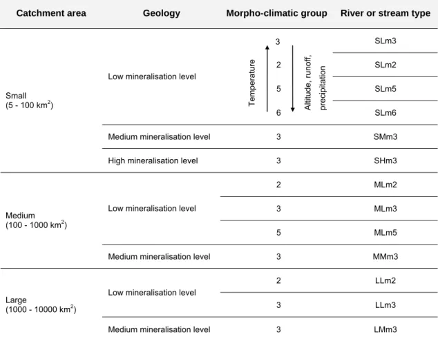
Box 1.2. WFD typology systems: WFD System-A and B were established to differentiate surface water bodies with respect to a physical type. System-A defines types according to ecoregions (Illes, 1978) and is based on fixed categories for altitude (lowland< 200, mid-altitude 200-800, high> 800 m a.s.l.), catchment area (small 10-100, medium 100-1000, large 1000-10000, very large> 10000 km2) and geology (siliceous, calcareous,
organic); WFD System-B does not provide fixed ranges for these obligatory descriptors and includes two additional obligatory variables (latitude and longitude) and a variety of physical and chemical optional factors. System-A defines environmental features that influence biological communities but are not themselves influenced by man, while optional factors in System-B might be affected by human activities (Moog et al., 2004).
2. Climate change affecting running waters
While habitat change, pollution, over-exploitation and invasive species are considered to be amongst the most important current drivers of biodiversity change in running waters, climate warming is expected to become increasingly important (Sutherland et al., 2006). Temperature is not the only climate variable likely to change as a result of anthropogenic-related increases in greenhouse gases or natural changes in climate. In some regions, changes in precipitation, relative humidity, radiation, wind speed and/or potential evapotranspiration may be more marked than for temperature (Hulme, 2005). In running waters, as ecosystems characterized by ectotherms, hydrological dynamism and unidirectional flow, variations in temperature and/or discharge influence many stream processes (Durance & Ormerod, 2007). Consequently, rivers and streams are already being affected by changes in the climate and will be probably more affected in the future since climate change is expected to modify the severity/magnitude and frequency of extreme events such as droughts and floods (Roo, 2005; Runnalls et al., 2005). Climate change is recognized as a major threat to the survival of species and integrity of ecosystems world-wide since it may significantly reduce habitat suitability and may threaten species with limited dispersal ability and highly specialized (Hulme, 2005).
Natural variation and human impacts are therefore inextricably linked by climate change and cannot be easily segregated. Thus, finding, today, undisturbed stream sites, with no other human impact besides the inevitable influence of climate change, and characterizing their biological communities and abiotic features will help defining true RC, accurately achieving the
WFD goals and understanding some future impacts climate change is going to have on stream biota. Nevertheless, RC are likely to change with climate and should not be therefore considered as static (Vogt et al., 2005).
Several high mountain river systems (e.g., alpine streams) are not yet considerably affected by direct human-activities (very low population and no industrial development). In intensely human-managed systems, the direct effects of climate change may be either buffered or so completely confounded with other factors that they become impossible to detect. Conversely, in systems with little human manipulation, the effects of climate change are most transparent (McCarthy et al., 2001). Simultaneously, mountain environments are amongst the most sensitive to climate change /variability (Allan & Flecker, 1993) because of the very strong coupling between atmospheric conditions, snow packs (or glaciers), melt-water generation, stream flow, water quality (physico-chemical) and river ecology (McGregor et al.,1995; Hannah et al., 2007). Additionally, one of the most distinctive and ecologically influential characteristics of many headwater streams is natural drying (Fritz et al., 2006). Consequently, these near-natural, headwater environments might provide an almost unique insight into natural hydrological and ecological response to climate (Füreder et al., 2002).
3. Species richness in running waters
Surveys of all species within a freshwater community are unusual because taxonomic knowledge of many groups is inadequate and because the exhaustive compilation of species list is rarely a priority (Allan, 1995). However, a disproportional large fraction of the world’s total biodiversity (~ 9%) resides in freshwater ecosystems, since these systems take up only 0.01% of the total surface of the globe (Balian et al., 2008). This is why biodiversity is probably at greater risk in freshwater systems than in other ecosystems (Allan & Flecker, 1993; Abellán et al., 2007), which should imply complete taxa inventories in order to assess the rate of species loss and species migration due to human impacts. Whereas the available data on vertebrates and some emblematic invertebrate groups such as Odonata (dragonflies and damselflies) allow for a credible assessment, data are deficient for many other groups (Balian et al., 2008). The lack of species lists for many lotic systems most certainly hinder rivers condition bioassessment, the successful restoration of the natural structural and functional integrity of an ecosystem, and the prediction of climate change impact on freshwater biodiversity.
Macroinvertebrates: important role in stream function and assessment
Macroinvertebrates have become the most commonly used, widely known and robust biological indicators in freshwater ecosystems (e.g., Rosenberg & Resh, 1993; Mancini, 2006).
Chapter 1
250-1000 μm screen (De Pauw et al., 2006). Most of them are, in fact, larger than 1 mm (e.g., Rosenberg & Resh, 1993; Tachet et al., 2000). In the present thesis macroinvertebrates are defined as organisms retained on a 250 μm screen. In general, aquatic macroinvertebrates inhabit the bottom substrates of watercourses (thus, commonly termed as benthic invertebrates) but some groups are free swimmers or most related to the water surface film (e.g., Williams & Feltmate, 1992; Tachet et al., 2000). The main constituents of this group are young aquatic stages of insects but also other arthropods, bivalves and snails, flatworms, worms and leaches among others.
Macroinvertebrates perform a variety of functions in freshwater systems including detritus decomposition, the release of nutrients by feeding activities, excretion, and burrowing into sediments, regulation of abundance, location and size of their prey, supplying food to aquatic and terrestrial consumers and promoting nutrient transfer to adjacent riparian zones of streams (Covich et al., 1999).
Their important and successful role in bioassessment is due to communities’ characteristics, behavioural and physiological features and advanced collection, identification and analysis methods (e.g., Rosenberg & Resh, 1993; Yoder & Rakin, 1998) that clearly outweigh the existing difficulties (Box 1.3).
Box 1.3. Macroinvertebrates are suitable as bioindicators because of: [1] their ubiquity, [2] high abundance and diversity throughout the river system, [3] sedentary nature allowing local and spatial analysis in general, since are less able to avoid potential harmful conditions than mobile species, [4] low-cost and simplicity of the collection methods with low impact in the community, [5] relatively easy identification since taxonomy of many groups is well known, [6] differential sensitivity (due to very diverse physiological tolerances and life and feeding strategies) and a fast reaction to several pressures that are already well described, [7] their life cycles diversity, ranging from a few weeks to a few years, which make them living records of
cumulative stress and exposure over time, [8] many species suitability for experimental studies of pollution effects and [9] a comparatively large amount of data already exists (Hellawell, 1977; De Pauw & Vanhooren, 1983; Rosenberg & Resh, 1993; Resh, 1995; Yoder & Rakin, 1998). On the other hand, [1] quantitative sampling requiring large number of samples, [2] the time and cost required for identification, especially to lower taxonomic levels, [3] invertebrate seasonal variation complex data interpretation (Rosenberg & Resh, 1993; Resh, 1995) or [4] restricted geographic distribution impeding the existence of a universal assessment system (Sandin et al., 2000) are pointed as restrictions in the use of macroinvertebrates as a bioassessment tool.
1. Assessment tools
Through the years, and still today, numerous macroinvertebrate-based measures, indices, designs and methods of data analysis have been developed and proposed to integrate characterization and monitoring protocols of rivers and streams and are, therefore, available to help evaluating effects of a stressor (human activity) on the environment. Although these methodologies address suborganismal (biomarkers at molecular, cell and tissue level), organismal (toxicity tests on specimens), population (fluctuating asymmetry), community (multimetric and multivariate approaches, functional feeding groups and multiple biological traits) and ecosystem (benthic secondary production, leaf-litter decay) organizational levels, community-level approaches are currently the most widely used (Bonada et al., 2006a).
Very recently, Prat et al. (in prep.), based on Bonada et al.’s (2006a) work, classified methods using the macroinvertebrate community to assess ecological quality of freshwater into four major categories: [1] single metric indices, which include non-taxonomic metrics, sensitivity/tolerance metrics and functional metrics (Box 1.4); [2] biological traits, which consist in using a combination of organisms’ biological and ecological attributes as indicator of quality conditions (Box 1.4); [3] multimetric indices, which result from the combination of metrics that individually provide information on different characteristics of the community but together are presumed to represent a range of community responses to human impact (Box 1.5) and [4] multivariate methods, which predict the expected invertebrate community that should occur at a test site with specific habitat attributes (Box 1.5).
Besides the above classified methods there is also the ANOVA (BACI) design. In Green’s (1979) BACI design (Before/After-Control/Impact studies) a sample is taken before and another after the possible disturbance in the impacted and in the control locations. The environmental disturbance should appear as a difference in mean abundance of the sampled population. However, this difference could be caused by a natural agent. Thus, several alterations have been performed to the initial BACI design to include temporal and spatial replication (Underwood, 1994). However, the relative complexity of these designs together with the common constrains (time and money) support the development of more user-friendly approaches.
Chapter 1
Box 1.4. Macroinvertebrate-based measures might vary depending on the stream or river type, river, basin, region or continent of interest and on the stressor in question. In fact, the number of macroinvertebrate-based measures is even higher since they were created for different levels of taxonomic resolution (e.g., genus, family and order). Some examples of methods according to Prat et al.’s (in press) classification are: [1] Margalef’s index (Margalef, 1951), Simpson’s index (Simpson, 1949), Belgian Biotic Index (De Pauw & Vanhooren, 1983), IBMWP (Alba-Tercedor & Sánchez-Ortega, 1988) for single metrics indices and [2] body form and size and feeding habits (Tachet et al., 2000) for biological traits. A single measure might not be helpful for the purpose of assessment. Thus, when some of the indices included in single metrics indices are interpreted individually they may not reflect the overall ecological health (Barbour et al., 1995). This is due to the fact that diversity and biotic indices are based on different assumptions. In general, diversity indices relate the number of observed taxa to the number of individuals (e.g., Simpson’s index). The principle is that disturbance leads to a reduction in diversity. These indices are easy to calculate, applicable to all kind of watercourses and are best used for comparative
purposes (De Pauw et al., 2006). Biotic indices are numerical expressions based upon indicator organisms, that is, tolerance or sensitivity of aquatic organisms to different types and/or magnitudes of disturbances (e.g., IBMWP) (Davis, 1995). The principle is that intolerant macroinvertebrate groups disappear as pollution increases and that the number of taxonomic groups is reduced as disturbance increases (De Pauw et al., 2006). The advantage of biotic indices is the reduction of long taxa lists and technical explanations, complex interactions and pollution responses of an aquatic community into a single number or an interval of values, which corresponds to a quality class (Davis, 1995). However, they are normally developed for a specific region. Some disadvantages of both diversity and biotic indices might be overcome by the use of multimetric indices. The biological traits approach consists in using multiple organisms’ biological and ecological attributes as indicator of environmental constraints. The advantage of this approach relates to its large-scale applicability and its major problem concerns the consistent description of invertebrate taxa traits, because this information is currently lacking for many regions (Bonada et al., 2006a).
Consequently, different assessment methods have been performed with the macroinvertebrate community, all depending, although at different levels, on having information on undisturbed macroinvertebrate communities to compare with data from potentially impacted sites. The RCA (sensu Reynoldson et al., 1997; see Bioassessment and the reference condition approach in running waters section of this introduction) has been performed world wide with benthic invertebrate communities using multimetric and multivariate approaches (e.g., Wright et al., 1984; Davies, 2000; Wright, 2000; Feio et al., 2007) (Box 1.5).
Box 1.5. Multimetric and multivariate methods require ecological classification to be based on deviations from the expected natural condition and are therefore based on the RCA. The underlying principle of both methods is that the biota is the ultimate integrator of all human actions (Karr & Chu, 2000). In multimetric methods [e.g., B-IBI (Karr, 1999)], mostly used in the USA (Reynoldson et al., 1997) but with some European examples [IM9 (Pinto et al., 2004)], several metrics that individually provide information on different characteristics of the macroinvertebrate community are integrated into one index value score, which is the expression of the overall quality (Barbour et al., 1995). Recently, as a consequence of the publication of the WFD multimetric systems are currently being developed and implemented in Europe. However, in some European countries the multivariate approach is still very common and is being adapted to the WFD requisites. This second approach predicts the expected invertebrate community that should occur at a test site with specific habitat attributes. Ideally, the environmental variables used to associate test sites with reference sites should not be influenced by human impact. This approach started using macroinvertebrate presence/
absence data [RIVPACS I in the UK (Wright et al., 1984; Wright, 2000) and AusRivAS in Australia (Davies, 2000)] and later including quantitative data [RIVPACS III (Wright, 2000) and BEAST in Canada (Reynoldson et al., 1995)]. Similar systems were already developed for Sweden (Sandin et al., 2001), Czech Republic (Kokeš et
al., 2006) and Portugal (Feio et al., 2007). In the
multimetric approach test sites are compared to reference sites belonging to the same morpho-physical geographic group, while multivariate models use habitat attributes to predict the reference-site group to which the test site is most likely to belong and should be compared. Multimetrics are attractive because they produce a single score that is comparable to a target value. However, metrics are often redundant in a combination index and not all information collected is used. Multivariate methods are advantageous since they require no prior assumptions either in creating groups out of reference sites or in comparing test sites with reference groups using probability ellipses or ratios between the observed and the expected biota. However, the complexity of the initial model construction may discourage the use of this method (Reynoldson et al., 1997).
2. Spatial and temporal patterns
In the WFD the RCA using macroinvertebrates (benthic invertebrate fauna) is also one of the key-approaches in assessing the ecological status of rivers and, regardless of how the data will ultimately be analysed, ensuring some consistency of the macroinvertebrate data will allow comparisons among studies and regions. That is the major reason for the recent European discussion involving benthic invertebrates and sampling methods, taxonomic resolution, validation of reference sites and concordance with physical stream and river types
Chapter 1
spatial and temporal natural variation patterns of the macroinvertebrate community (e.g., Wiberg-Larsen et al., 2000; Ehlert et al., 2002; Morais et al., 2004; Sandin & Johnson, 2004) emerges from the need to differentiate the effects of natural variability from human-induced variations and thus defining RC to benthic invertebrates in coherence with the WFD stipulation.
Patterns of macroinvertebrate communities are commonly best explained by a group of environmental and biotic variables but several single factors are responsible for a major proportion of the invertebrate natural variability. Although they may differ within each geographic region (type), some of the best known factors determining invertebrate community structure are: sediment quality and heterogeneity (e.g., Malmqvist, 1999; Beisel et al., 2000; Rae, 2004), water quality features such as pH and organic matter (e.g., Hellawell, 1986; Alba-Tercedor & Sánchez-Ortega, 1988), hydrological conditions and stream size characteristics such as width, depth and distance from source (e.g., Wright et al., 1984; Malmqvist, 1999; Sandin, 2003), geomorphology characteristics such as altitude and slope (Feio et al., 2005), water permanence (Bonada et al., 2006b) and biological factors (e.g., Kohler, 1992; MacNeil et al., 1999). Spatial but also temporal scales consequently influence the macroinvertebrate community structure and might therefore limit the applicability of stream assessment methods.
The high temporal variability of stream invertebrates (species-specific differences in emergence, birth and death rates) occurring in some regions of the world (e.g., mediterranean areas) is strongly influenced by climatic events and will be probably affected by climate change. Water temperature is known to control to some extent abundance and distribution of macroinvertebrates by influencing directly organism growth and community voltinism (Williams & Feltmate, 1992) and indirectly through dissolved oxygen, primary production, decomposition and litter processing (Durance & Ormerod, 2007). From a hydrological perspective, hydraulic conditions, floods and droughts have direct effects on the presence or displacement of organisms (Lake, 2000; Durance & Ormerod, 2007). Although the effects of floods have been relatively well studied, those of droughts have been largely neglected (Lake, 2000). Aquatic insects may respond to these natural disturbances behaviourally, by migrating from or changing distribution (refugia) within stressed regions, or physiologically, by adjusting growth, development, size, condition and fecundity (Williams & Feltmate, 1992).
3. Lack of taxonomic studies
Although macroinvertebrates are extremely important to the function and structure of stream communities, their taxonomy in some regions, contrarily to most freshwater vertebrate groups, is so far poorly known. This is particularly true for the family Chironomidae partly due to the lack of adequate taxonomic bibliography but mostly because Chironomidae genus/species resolution requires high taxonomical skills and is extremely laborious and very time consuming
(Rabeni & Wang, 2001). However, Chironomidae are common inhabitants of most aquatic habitats, and often dominate aquatic insect communities in both abundance and species richness, representing one of the freshwater invertebrate groups with higher species richness (Allan & Flecker, 1993, Balian et al., 2008). They exhibit extreme elevational ranges, and are amongst the most tolerant aquatic insects to water and air temperatures. Chironomidae larval and pupal stages are typically constrained to aquatic habitats while adults are aerial. A total of 339 genera and 4,147 species can be considered unambiguously aquatic in their immature stages and in the Palaearctic region 181 aquatic genera enclosing 1321 species are already known and some are still to be found (Ferrington, 2008). In the Iberian Peninsula, the family Chironomidae has received some attention but mostly in the Spanish territory (e.g., Soriano et al., 1997).
Mediterranean streams and the Mondego River basin as a case study
Streams under the influence of Mediterranean-type climate (i.e. seasonal and variable intensity in rainfall and temperature regimes) are usually named mediterranean streams. They have a distinct cool and wet season followed by a warm dry season and may present flooding and drying periods (Gasith & Resh, 1999). As a result, mediterranean streams are naturally stressed. Depending on the frequency and intensity of droughts and floods, mediterranean areas enclose permanent and temporary (intermittent, ephemeral) streams. Climate change scenarios indicate that floods and droughts magnitude and frequency are likely to increase in mediterranean regions (Roo, 2005; Runnalls et al., 2005).
Although the Mediterranean-type climate occurs in five areas of the world, over one half of its total area is located around the Mediterranean Sea basin between 30º and 45º N (Gasith & Resh, 1999). The climate in Portugal is typically Mediterranean, although the mediterranean influence vanishes from South to North and from the Atlantic Ocean towards inland (Ribeiro, 1989).
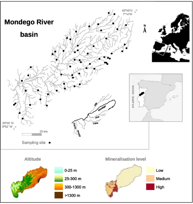
The Mondego River basin (MRb) is entirely located in the central region of Portugal, between 39º 46’ N and 40º 48’ N and 7º 14’ W and 8º 52’ W (Figure 1.3), in an area of Mediterranean climate, strongly influenced by the Atlantic Ocean. The average annual temperature (a.a.t.) is approximately 13 ºC, with the warmest temperatures registered near the coast (a.a.t. 16 ºC) and the lowest recorded in Estrela and Caramulo Mountains (a.a.t. 10 ºC). In general, the hottest months are July and August and the coldest are December and January. The average annual precipitation is 1130 mm, with a humid semester between October and March and the driest months being July and August (Lima & Lima, 2002).
Chapter 1
The MRb drains an area of 6645 km2 into the Atlantic Ocean (Loureiro et al., 1986) and its aquatic systems cover less than 1% of the Mondego catchment area. The Mondego itself is the largest entirely Portuguese river with a length of 234 km, beginning at an altitude of 1547 m a.s.l. in Serra da Estrela (Loureiro et al., 1986). The altitude of the drainage basin ranges from nearly 2000 m a.s.l. to sea level. Only 2.1% and 0.6% of the Mondego River catchment area is above 1200 m and 1500 m a.s.l., respectively, and the average altitude of the drainage basin is 375 m a.s.l. Mondego River main tributaries are Dão, on the right bank, and Alva, Ceira, Arunca and Pranto on the left bank (Loureiro et al., 1986).
As expected, this basin has high variability of the annual freshwater discharge and consequently several rivers and streams vary from flooded to dry in the same year (Lima & Lima, 2002). The natural hydrology of the basin has been heavily changed by the construction of several major dams (since 1940) and hundreds of small weirs, yet, a seasonal discharge pattern is clearly present.
Hydrogeologically there are two major areas in the MRb, an essentially siliceous area in the upper and middle regions of the basin and a mainly calcareous area in its lower section (AMBIO et al., 1999). The calcareous section includes areas with different mineralization levels, medium and high (Figure 1.3) (INAG, 2008).
As most Mediterranean basins, the MRb is subjected to numerous other human pressures besides damming. Intensive and extensive agricultural areas, although declining in size, cover respectively about 5% and more than 35% of the catchment area and are located mainly in the lower region of the MRb and in Dão and Arunca River valleys. Other artificial areas (urban, industrial and roads) account for 3% of the Mondego River catchment area. Human pressure is stronger along the main rivers and in the coastal region (AMBIO et al., 1999; Marques et al., 2002), with approximately 670,000 people living in the catchment area (AMBIO et al., 1999). Harvesting timber, mainly for pulp production (Eucalyptus globulus Labill.), is a widespread practice across this catchment (Marques et al., 2002). Generally, these human activities decrease longitudinal connectivity, increase diffuse pollution, sediment loads and nutrient enrichment and damage the riparian wood, the banks and the in-stream habitats (e.g., Hughes et al., 2007). Nonetheless, natural or semi-natural areas cover more than 50% of Mondego River catchment.
All samples used in the present thesis were collected in the MRb.
Mondego River
basin
39º46’ N 8º52’ W 40º48’N 7º14’W 20 km Sampling site A TLA N T IC O C EA N N Mond ego Dão A run c a Alva Ceira P ran to Mond ego Dão A run c a Alva Ceira P ran to 0-25 m 25-300 m 300-1300 m >1300 m Altitude Low Medium High Mineralisation levelMondego River
basin
39º46’ N 8º52’ W 40º48’N 7º14’W 20 km Sampling site A TLA N T IC O C EA N N Mond ego Dão A run c a Alva Ceira P ran to Mond ego Dão A run c a Alva Ceira P ran toMondego River
basin
39º46’ N 8º52’ W 40º48’N 7º14’W 20 km 20 km Sampling site Sampling site A TLA N T IC O C EA N A TLA N T IC O C EA N A TLA N T IC O C EA N N N Mond ego Dão A run c a Alva Ceira P ran to Mond ego Dão A run c a Alva Ceira P ran to 0-25 m 25-300 m 300-1300 m >1300 m 0-25 m 25-300 m 25-300 m 300-1300 m 300-1300 m >1300 m >1300 m Altitude Low Medium High Low Medium High Mineralisation levelFigure 1.3 - Geographic position of the MRb with detailed location of main tributaries and of all sites sampled during the present thesis. Catchment altitude and mineralisation-related information [modified from INAG (2008)] is also given.
Aims and importance of this study
Available comprehensive scientific data on roughly undisturbed macroinvertebrate communities of Portuguese rivers and streams is very scarce, either because unaltered stream reaches are increasingly rare or no real effort (time and money) was put into the subject. However, this kind of data became crucial with the: [1] publication of the WFD that gave the highest priority to benthic invertebrate fauna in assessing the ecological status of rivers and streams by selecting macroinvertebrates as one of the biological quality elements; [2] certainty
![Table 1.1. Characteristics of top-down and bottom-up approaches for water body type determination [adapted from van de Bund & Solimini (2007)]](https://thumb-eu.123doks.com/thumbv2/123dok_br/15560806.1046778/32.892.121.772.637.785/table-characteristics-approaches-water-determination-adapted-bund-solimini.webp)