UPDATES ON THE HABITAT USE AND MIGRATIONS OF SHORTFIN MAKO IN THE
ATLANTIC USING SATELLITE TELEMETRY
Catarina C. Santos1,*, Andrés Domingo2, John Carlson3, Lisa Natanson4, Paulo Travassos5, David Macias6, Enric Cortés3, Philip Miller7, Fabio Hazin5, Federico Mas7, Josetxu Ortiz de Urbina6, Rui
Coelho1
SUMMARY
This paper provides an update of the study on habitat use for shortfin mako, developed within the ICCAT Shark Research and Data Collection Program (SRDCP). A total of 43 tags (29 miniPATs and 14 sPATs) have been deployed by observers on Portuguese, Uruguayan, Brazilian, Spanish and US vessels in the temperate NE and NW, Equatorial and SW Atlantic. Data from 41 tags/specimens are available, and a total of 1656 tracking days have been recorded. Results showed shortfin mako moved in multiple directions, travelling considerable distances. Shortfin mako sharks spent most of their time above the thermocline (0-90 m), between 18 and 22 °C. The main plan for the next phase of the project is to continue the tag deployment during 2019 in several regions of the Atlantic.
KEYWORDS: Habitat use; Movement patterns; Satellite tagging; Shortfin mako; Sharks research program.
1: IPMA - Portuguese Institute for the Ocean and Atmosphere. Av. 5 de Outubro s/n, 8700-305 Olhão, Portugal.
2: DINARA - Dirección Nacional de Recursos Acuáticos, Laboratorio de Recursos Pelágicos. CP 11200 Montevideo, Uruguay. 3: NOAA Fisheries - Southeast Fisheries Science Center. Panama City, FL, US.
4: NOAA Fisheries - Northeast Fisheries Science Center. Narragansett Laboratory, RI, US.
5: Departamento de Pesca e Aquicultura, Universidade Federal Rural de Pernambuco, Av. Dom Manoel de Medeiros, s/n., Dois Irmãos, CEP: 52.171-030, Recife, PE, Brasil.
6: Instituto Español de Oceanografía, C.O. Málaga. Pto . Pesquero s/n, 29640, Fuengirola, España.
7: CICMAR - Centro de Investigación y Conservación Marina, Giannattasio km. 30,5 El Pinar, Canelones, CP 15008, Uruguay. *: Corresponding author: Catarina C. Santos: E-mail: [email protected]
1. Introduction
In 2013 the ICCAT Shark Species Group developed the general guidelines of the Shark Research and Data Collection Program (SRDCP), aimed at the development and coordination of science and science-related activities needed to support provision of sound scientific advice for the conservation and management of sharks in the Atlantic. During the 2014 inter-sessional meeting, the Sharks Working Group updated the SRDCP, which was framed within the 2015-2020 SCRS Strategic Plan. The initial 3-year implementation of this Research Program focuses on biological aspects, ecology and fisheries of shortfin mako (Isurus oxyrinchus) that are relevant to the stock assessment of this important species.
Know habitat use and migration patterns is important for management of fish populations. The knowledge of the movement patterns (i.e., use of space and activity patterns) is key to understanding the behavior of a species as well as defining essential habitats. The need to understand whether fish are migrating between regions that can be undergoing different types and levels of fishing activity is also very important. Another important aspect is related with quantifying mortality. However, even though those issues are of great importance, there is still limited information on the stock structure and post-release mortality of most pelagic elasmobranchs at an ocean wide level. Using incorrect assumptions about the stock structure, movements and mortality can lead to biased conclusions about the level of fishing that is sustainable. Therefore, information about these processes should be incorporated into stock assessments.
Given the wide range of information that can be gathered with satellite telemetry studies, within the ICCAT SRDCP, two studies using satellite telemetry were developed, specifically: 1) a study that uses satellite telemetry to gather and provide information on stock boundaries, movement patterns and habitat use of shortfin mako in the Atlantic; and 2) a study that uses satellite telemetry to determine post-release mortality of discarded specimens. This document presents the results of the habitat use study (1).
2. Materials and methods 2.1. Tag acquisition
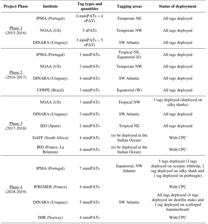
Two models of tags were used: MiniPAT and Survivorship PAT (sPAT) tags built by Wildlife Computers (WC). The first tag acquisition process was completed during October-November 2015 by the ICCAT Secretariat, and the tags were then distributed to the participating Institutes in late 2015. In this first project phase, a total of 9 miniPATs and 14 sPATs were acquired (funds from 2015). Additionally, in late 2016, 12 additional miniPATs were acquired with the funds from 2016 for deployment during 2017-2018, during the second phase of the project. As one of the original miniPATs (2015) failed due to a depth sensor problem, the tag manufacturer provided one additional replacement tag. In the third phase of the project, 20 miniPATs were acquired for deployment on shortfin mako as well as silky shark. The 20 miniPATs acquired during the fourth phase of the project are planned to be deployed on shortfin mako as well as other pelagic species such as the porbeagle, silky shark and oceanic whitetip. Table 1 describes the number of tags acquired during the four phases of the project and their allocation for deployment as well as the current deployment status.
2.2. Tagging procedure
Tagging took place across a wide area of the Atlantic Ocean, between 2015 and 2019, and was conducted onboard Uruguayan research vessel and vessels from the Portuguese, Brazilian, Spanish and US pelagic longline fleet (Figure
1). The tag deployment was opportunistic when sharks were captured during the regular fishing operations. Sharks
were either hoisted alongside the vessel or brought on board for tagging. An umbrella-type nylon dart was used to insert the tag laterally to the dorsal musculature below the first dorsal fin base, using the methodology described by Howey-Jordan et al. (2013). The entire tagging operation lasted a maximum of 2 minutes, and did not produce any additional injuries or damage to the specimens. Before tag attachment, tags were tested for accurate data collection, and were programmed to record information for periods between 30 and 120 days. In addition, the animals were sexed and measured for fork length (FL). Date and time were recorded, and the geographic tagging location (latitude and longitude) was determined by Global Positioning System (GPS).
2.3. Data analysis
Geographic positions at tagging were determined by GPS, while the pop-up locations of transmitting tags were established as the first point of transmission with an Argos satellite. In order to investigate movement patterns, the most probable tracks between tagging and pop-up locations were calculated from miniPATs light level data using astronomical algorithms provided by the tag manufacturers. To improve the geolocation accuracy, a state-space model incorporating a sea surface temperature field was applied using the Wildlife Computers GPE3 software (Wildlife Computers, 2015). In the case of sPATs, light sensors are not optimized for geolocation. Therefore, the distances travelled by the sharks tagged with sPATs were measured in straight lines between the tagging and the pop-up locations.
Vertical habitat use was only analyzed for sharks tagged with miniPATs. Vertical habitat use was investigated by calculating the percentage of time-at-depth and time-at-temperature, and was separately analyzed for daytime and nighttime. Sunset and sunrise were calculated using library “RAtmosphere” in R (Biavati, 2014), and took into account the date (Julian day), latitude and longitude (Teets, 2003). Time-at-depth and time-at-temperature data were aggregated into 30 m and 2°C bins, respectively, based on the above analyses. These data were subsequently expressed as a fraction of the total time of observation for each shark, and the fractional data bins averaged across all sharks within each category.
All statistical analyses for this paper were carried out with the R language (R Core Team, 2018). Plots were created using libraries “plotrix” (Lemon, 2006) and “ggplot2” (Wickham, 2009).
3. Results and Discussion 3.1. Tag performance
43 tags (29 miniPATs and 14 sPATs) were deployed during this study (Figure 1), with data from 41 tags successfully transmitted. A total of 1656 tracking days was registered (Table 2).
3.2. Movement patterns
Estimated most likely tracks of sharks tagged with miniPATs are shown in Figure 2. For sharks tagged with sPATs, the tagging and the pop-up locations were connected with straight lines to become track segments (Figure 3). The distances travelled ranged from 30 km to 9035 km for 2 and 47 tracking days, respectively (Table 3).
In terms of movements, it is interesting to note that specimens tagged in the temperate NE Atlantic moved, predominantly, to southern areas off the Canary archipelago and west Africa. Generally, sharks tagged in the Equatorial region of the Atlantic moved easterly, with the exception of shark 169528 which moved west towards the region closer to the South American continental shelf. Shark 167208 travelled more than 8900 km along the African west coast. The specimens tagged in the SW Atlantic off Uruguay followed oscillatory swimming patterns and tended to stay in the same general area. Finally, for sharks tagged in the temperate NW Atlantic no clear pattern in horizontal movements was observed. Specifically, shark 167204 moved north while shark 167203 moved south towards the Caribbean coastal waters and then returned north. Sharks tagged with sPATs in the NW Atlantic followed general southern movements.
This preliminary analysis confirmed that the shortfin mako has a wide geographic distribution and is found in both hemispheres from high-latitude temperate regions to tropical zones (Abascal et al., 2011; Vaudo et al., 2017). Horizontal movements showed shortfin makos moved in multiple directions and travelled long distances, confirming the species migratory nature (Compagno, 2001). The reasons for these movements are unknown, although several aspects related to foraging, reproduction and water temperature might explain them (Casey and Kohler, 1992; Holts and Bedford, 1993; Passarelli et al., 1995; Petersen, 2007, Vaudo et al., 2017).
3.3. Vertical habitat use
Shortfin makos swam through a depth range from the surface down to 740 m, with mean depth of 70.29 m. Water temperatures ranged between 7.40 and 29.90 ºC, with mean temperature of 19.45 ºC. However, sharks spent most of their time in depths above 90 m and preferred a range of water temperatures from 18 to 22 ºC, during both daytime and nighttime (Figure 4). The results described were consistent with previous studies (e.g., see Casey and Kohler, 1992; Loefer et al., 2005; Stevens et al., 2010; Abascal et al., 2011; Vaudo et al., 2016).
4. Contribution of SMA satellite telemetry data from other projects
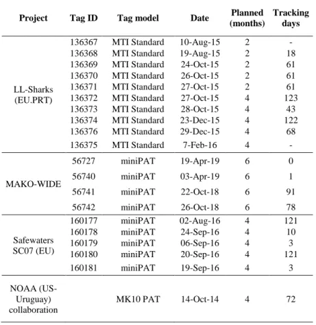
The participating scientists and Institutes in this study had also other ongoing projects and initiatives that also included the deployment of satellite telemetry tags in SMA (see details in Table 4):
• Project LL-Sharks: 10 tags have been deployed on SMA specimens by Portuguese fishing vessels in the tropical NE and equatorial regions within the scope of Project LL-Sharks (Mitigação das capturas de tubarões na pescaria de palangre de superfície; Ref: 31-03-05-FEP-44; funded by PROMAR).
• Project MAKO-WIDE: Within project MAKO-WIDE - A wide scale hemispheric and inter-disciplinary study aiming the conservation of the shortfin mako shark in the Atlantic Ocean; Ref: FAPESP/19740/2014; funded by FCT-Portugal and FAPESP-São Paulo, Brazil), 16 miniPAT tags were acquired, to be deployed by Portuguese vessels in the NE tropical and temperate Atlantic. Currently, this project deployed 4 tags on SMA specimens in the temperate NE and equatorial regions.
• Project SAFEWATERS SC-07: This project (The provision of advice on the conservation of pelagic sharks associated to fishing activity under EU Sustainable Fisheries Partnership Agreements in the Atlantic Ocean, under the Framework Contract MARE/2012/21, funded by the European Commission) deployed 5 miniPATs in SMA in the EEZ of Cabo Verde (tropical NE Atlantic).
• NOAA (US-PRT-URY) collaboration project: Within this collaboration project that involves scientists from NOAA (US), DINARA (Uruguay) and IPMA (Portugal), 9 miniPATs have been acquired by NOAA and are in the process of being deployed in the NW Atlantic. Additionally, one previous tag also from NOAA was deployed in 2014 by Uruguay in the SW Atlantic.
5. Project progress and future steps
Currently, all tags from phase 1 and 2 have been deployed. Regarding phase 3, 8 of the 20 miniPATs acquired have been deployed. 8 of these tags are planned to be deployed in the Indian Ocean in order to assess inter-ocean movements of shortfin mako. 10 of the 20 tags acquired during phase 4 have already been deployed. Additional tags have also been deployed by national programs and projects that are cooperating with the ICCAT/SRDCP initiative. The main plan for the next phase of the project is to continue the tag deployment during 2019 in the Atlantic and Indian Ocean. The main deliverables and outcomes expected for these projects are SCRS papers. Submission of the final results to peer-review journals is also envisioned pending agreement of all participants in the study.
6. Acknowledgments
This study was carried out as part of a cooperative work conducted by the ICCAT Shark species group integrated in the ICCAT Shark Research and Data Collection Program (SRDCP). The authors are grateful to all fishery observers and longline skippers from the Nations involved in this study. Tags from additional sources have been contributed and deployed with several national Projects, specifically: Project "LL-Sharks: Mitigação das capturas de tubarões na pescaria de palangre de superfície (Ref: 31-03-05-FEP-44, funded by PROMAR)", Project "MAKO-WIDE - "A wide scale inter-hemispheric and inter-disciplinary study aiming the conservation of the shortfin mako shark in the
Atlantic Ocean (Ref: FAPESP/19740/2014)", funded by FCT (Portuguese Foundation for Science and Technology) and FAPESP (São Paulo Research Foundation, Brazil), and Project SAFEWATERS SC7 (The provision of advice on the conservation of pelagic sharks associated to fishing activity under EU Sustainable Fisheries Partnership Agreements in the Atlantic Ocean) under the Framework Contract MARE/2012/21, funded by the European Commission. Additional satellite tags were acquired by NOAA in US-Uruguay and US-Portugal-Uruguay collaboration initiatives. Rui Coelho is supported by an Investigador-FCT contract from the Portuguese Foundation for Science and Technology (FCT) supported by the EU European Social Fund and the Programa Operacional Potencial Humano (Ref: IF/00253/2014). Catarina C. Santos is supported by an FCT Doctoral grant (Ref: SFRH/BD/139187/2018).
7. References
Abascal F.J., Quintans M., Ramos-Cartelle A., Mejuto J. 2011. Movements and environmental preferences of the shortfin mako, Isurus oxyrinchus, in the southeastern Pacific Ocean. Mar Biol 158: 1175–1184.
Casey J.G., Kohler N.E. 1992. Tagging studies on the shortfin mako shark (Isurus oxyrinchus) in the western North Atlantic. Aust J Mar Freshwat Res 43:45–60.
Compagno L.J.V. 2001. Sharks of the world: an annotated and illustrated catalogue of shark species known to date, vol 2: Bullhead, mackerel and carpet sharks (Heterodontiformes, Lamniformes and Orectolobiformes). FAO species Catalogue for Fishery Purposes, no 1, vol 2, pp 269.
Howey-Jordan L.A., Brooks E.J., Abercrombie D.L., Jordan L.K., Brooks A., Williams S., Gospodarczyk E., Chapman D.D. 2013. Complex movements, philopatry and expanded depth range of a severely threatened pelagic shark, the oceanic whitetip (Carcharhinus longimanus) in the western North Atlantic. PloS one 8:e56588.
Holts D.B., Bedford D.W. 1993. Horizontal and vertical movements of the shortfin mako shark, Isurus oxyrinchus, in the Southern California Bight. Aust J Mar Freshwat Res 44:901–909.
Lemon J. 2006. Plotrix: a package in the red light district of R. R-news 6:8-12.
Loefer J.K., Sedberry G.R., McGovern J.C. 2005. Vertical movements of a shortfin mako in the western North Atlantic as determined by pop-up satellite tagging. Southeast Nat 4: 237–246.
Passarelli N., Knickle C., DiVittorio K. 1995. Isurus oxyrinchus: Florida Museum of Natural History. Retrieved June 17, 2018, from https://www.floridamuseum.ufl.edu/fish/discover/species-profiles/isurus-oxyrinchus/.
Petersen S., Nel D., Omardien A. 2007. Towards an Ecosystem Approach to Longline Fisheries in the Benguela: an assessment of impacts on seabirds, sea turtles and sharks. WWF Report Series - 2007/Marine/001.
R Core Team. 2018. R: A language and environment for statistical computing. R Foundation for Statistical Computing, Vienna, Austria. Available from: http://www.R-project.org/.
Stevens J.D., Bradford R.W., West G.J. 2010. Satellite tagging of blue sharks (Prionace glauca) and other pelagic sharks off eastern Australia: depth behaviour, temperature experience and movements. Mar Biol 157:575-91.
Teets D.A. 2003. Predicting sunrise and sunset times. The College Mathematics Journal 34:317-21.
Vaudo J.J., Byrne M.E., Wetherbee B.M., Harvey G.M., Shivji M.S. 2017. Long‐term satellite tracking reveals region‐specific movements of a large pelagic predator, the shortfin mako shark, in the western North Atlantic Ocean. J Appl Ecol 54:1765-1775.
Vaudo J.J., Wetherbee B.M., Wood A.D., Weng K., Howey-Jordan L.A., Harvey G.M., Shivji M.S. 2016. Vertical movements of shortfin mako sharks Isurus oxyrinchus in the western North Atlantic Ocean are strongly influenced by temperature. Mar Ecol Prog Ser 547:163-175.
Wickham H. ggplot2: elegant graphics for data analysis. 1st ed. New York: Springer. 2009. Available from:
https://CRAN.R-project.org/package=ggplot2.
Wildlife Computers. 2015. Data Portal’s Location Processing (GPE3 & FastLoc-GPS) User Guide. Retrieved June 17, 2018, from https://wildlifecomputers.com/wp-content/uploads/manuals/Location-Processing-User-Guide.pdf.
Tables
Table 1. List with the distribution of miniPATs and sPATs by the participating Institutes, for the 4 phases of the
project. Current deployment status and additional notes are also provided.
Project Phase Institute Tag types and
quantities Tagging areas Status of deployment
Phase 1 (2015-2016)
IPMA (Portugal) 6 miniPATs + 4
sPATs Temperate NE All tags deployed
NOAA (US) 5 sPATs Temperate NW All tags deployed
DINARA (Uruguay) 3 miniPATs + 5
sPATs SW Atlantic All tags deployed
Phase 2 (2016-2017)
IPMA (Portugal) 3 miniPATs Tropical NE,
Equatorial (E) All tags deployed NOAA (US) 3 miniPATs Temperate NW All tags deployed DINARA (Uruguay) 4 miniPATs SW Atlantic All tags deployed UFRPE (Brazil) 3 miniPATs Equatorial (W) All tags deployed
Phase 3 (2017-2018)
NOAA (US) 7 miniPATs Tropical NW 3 tags deployed (deployed on silky sharks) DINARA (Uruguay) 3 miniPATs SW Atlantic All tags deployed
IEO (Spain) 2 miniPATs Tropical NE All tags deployed DAFF (South Africa) 4 miniPATs (to be deployed in the
Indian Ocean) With CPC
IRD (France, La
Réunion) 4 miniPATs
(to be deployed in the
Indian Ocean) With CPC
Phase 4 (2018-2019)
IPMA (Portugal) 7 miniPATs Equatorial, NW Atlantic
5 tags deployed (3 tags deployed on oceanic whitetip, 1 tag deployed on silky shark and 1 tag deployed on porbeagle)
IFREMER (France) 4 miniPATs With CPC
DINARA (Uruguay) 5 miniPATs SW Atlantic
All tags deployed (4 tags deployed on shortfin mako and
1 tag deployed on scalloped hammerhead)
Table 2. Total tracking days of shortfin mako sharks (Isurus oxyrinchus). N is the number of tags deployed for tag
model.
Tag model Tracking days
miniPAT (N=28) 1342
sPAT (N=13) 314
Total 1656
Table 3. Characteristics of the tracks taken by shortfin mako sharks, Isurus oxyrinchus, with information on effective
tracking days and distance travelled. Note that sPATs are marked with a star (*).
Tag ID Tracking days Distance travelled (km)
52912 32 1412 52919 47 2741 52924 71 3986 52925 59 3026 52927 0 - 62566 27 1775 62587 40 2354 62621 0 - 70638 30 1933 157339 121 3958 157340 2 30 157341 120 2131 157342 66 2396 157343 17 802 157344 2 347 157345 5 349 157346 - - 157347 21 225 167199 33 1030 167201 120 4537 167202 18 1091 167203 47 9035 167204 73 6695 167206 10 1349 167207 36 5830 167208 117 8931 167209 85 4513 167210 23 1572 169528 120 6781 157365* 30 367 157366* 30 561 157367* 30 1171 157368* 30 104 157369* 29 530 157370* 30 476 157371* 1 33 157372* 30 270 157373* 30 278 157374* - - 157375* 30 1191
157376* 30 280
157377* 13 794
Table 4. Information from the tags deployed by participating national scientists and institutes with additional funds
from other sources and projects.
Project Tag ID Tag model Date Planned
(months)
Tracking days
LL-Sharks (EU.PRT)
136367 MTI Standard 10-Aug-15 2 - 136368 MTI Standard 19-Aug-15 2 18 136369 MTI Standard 24-Oct-15 2 61 136370 MTI Standard 26-Oct-15 2 61 136371 MTI Standard 27-Oct-15 2 61 136372 MTI Standard 27-Oct-15 4 123 136373 MTI Standard 28-Oct-15 4 43 136374 MTI Standard 23-Dec-15 4 122 136376 MTI Standard 29-Dec-15 4 68 136375 MTI Standard 7-Feb-16 4 -
MAKO-WIDE 56727 miniPAT 19-Apr-19 6 0 56740 miniPAT 03-Apr-19 6 1 56741 miniPAT 22-Oct-18 6 91 56742 miniPAT 26-Oct-18 6 78 Safewaters SC07 (EU) 160177 miniPAT 02-Aug-16 4 121 160178 miniPAT 24-Sep-16 4 10 160179 miniPAT 06-Sep-16 4 3 160180 miniPAT 20-Sep-16 4 121 160181 miniPAT 19-Sep-16 4 3 NOAA (US-Uruguay) collaboration MK10 PAT 14-Oct-14 4 72
Figures
Figure 1. Location of the satellite tag deployments (miniPATs and sPATs) for shortfin mako (Isurus oxyrinchus),
Figure 2. Most likely tracks of shortfin mako (Isurus oxyrinchus) tagged with miniPATs. The tagging locations are
Figure 3. Strait line tracks of shortfin mako (Isurus oxyrinchus) tagged with sPATs. The tagging locations are
Figure 4. Vertical habitat use ofshortfin mako (Isurus oxyrinchus), for daytime and nighttime in terms of depth and temperature.