www.atmos-meas-tech.net/8/4587/2015/ doi:10.5194/amt-8-4587-2015
© Author(s) 2015. CC Attribution 3.0 License.
EARLINET: potential operationality of a research network
M. Sicard1,2, G. D’Amico3, A. Comerón1, L. Mona3, L. Alados-Arboledas4, A. Amodeo3, H. Baars5, J. M. Baldasano6,7, L. Belegante8, I. Binietoglou8, J. A. Bravo-Aranda9, A. J. Fernández10, P. Fréville11,
D. García-Vizcaíno1, A. Giunta3, M. J. Granados-Muñoz4, J. L. Guerrero-Rascado4, D. Hadjimitsis12, A. Haefele13, M. Hervo11, M. Iarlori14, P. Kokkalis15, D. Lange1,2, R. E. Mamouri12, I. Mattis16, F. Molero10, N. Montoux11, A. Muñoz1, C. Muñoz Porcar1, F. Navas-Guzmán17, D. Nicolae8, A. Nisantzi12, N. Papagiannopoulos3,
A. Papayannis15, S. Pereira18, J. Preißler19, M. Pujadas10, V. Rizi14, F. Rocadenbosch1,2, K. Sellegri11, V. Simeonov13, G. Tsaknakis15, F. Wagner16, and G. Pappalardo3
1Dept. of Signal Theory and Communications, Remote Sensing Lab. (RSLab), Universitat Politècnica de Catalunya,
Barcelona, Spain
2Ciències i Tecnologies de l’Espai – Centre de Recerca de l’Aeronàutica i de l’Espai/Institut d’Estudis Espacials de
Catalunya (CTE-CRAE/IEEC), Universitat Politècnica de Catalunya, Barcelona, Spain
3Istituto di Metodologie per l’Analisi Ambientale (CNR-IMAA), C. da S. Loja, 85050 Tito Scalo, Potenza, Italy 4Departamento de Física Aplicada, Universidad de Granada, Granada, Spain
5Leibniz Institute for Tropospheric Research, Leipzig, Germany
6Earth Sciences Department, Barcelona Supercomputing Center – Centro Nacional de Supercomputación,
Barcelona, Spain
7Environmental Modeling Laboratory, Technical University of Catalonia, Barcelona, Spain 8National Institute of R&D for Optoelectronics, Magurele, Ilfov, Romania
9Laboratoire Meteorologie Dinamique (LMD), École Polytechnique, Palaiseau, France
10Centro de Investigaciones Energéticas, Medioambientales y Tecnológicas (CIEMAT), Madrid, Spain 11Observatoire de Physique du Globe, Laboratoire de Météorologie Physique (LaMP-CNRS),
Clermont-Ferrand, France
12Cyprus University of Technology, Limassol, Cyprus
13Federal Office of Meteorology and Climatology MeteoSwiss, Payerne, Switzerland
14CETEMPS, Dipartimento di Scienze Fisiche e Chimiche, Università degli Studi, L’Aquila, Italy 15Laser Remote Sensing Unit, Physics Dept., National Technical University of Athens, Athens, Greece 16Deutscher Wetterdienst, Observatorium Hohenpeißenberg, Hohenpeißenberg, Germany
17Institute of Applied Physics (IAP), University of Bern, Bern, Switzerland 18Évora Geophysics Center, University of Évora, Évora, Portugal
19Centre for Climate and Air Pollution Studies (C-CAPS), National University of Ireland Galway,
University Road, Galway, Ireland
Correspondence to:M. Sicard (msicard@tsc.upc.edu)
Abstract. In the framework of ACTRIS (Aerosols, Clouds, and Trace Gases Research Infrastructure Network) summer 2012 measurement campaign (8 June–17 July 2012), EAR-LINET organized and performed a controlled exercise of fea-sibility to demonstrate its potential to perform operational, coordinated measurements and deliver products in near-real time. Eleven lidar stations participated in the exercise which started on 9 July 2012 at 06:00 UT and ended 72 h later on 12 July at 06:00 UT. For the first time, the single calculus chain (SCC) – the common calculus chain developed within EARLINET for the automatic evaluation of lidar data from raw signals up to the final products – was used. All stations sent in real-time measurements of a 1 h duration to the SCC server in a predefined netcdf file format. The pre-processing of the data was performed in real time by the SCC, while the optical processing was performed in near-real time af-ter the exercise ended. 98 and 79 % of the files sent to SCC were successfully pre-processed and processed, respectively. Those percentages are quite large taking into account that no cloud screening was performed on the lidar data. The paper draws present and future SCC users’ attention to the most critical parameters of the SCC product configuration and their possible optimal value but also to the limitations inherent to the raw data. The continuous use of SCC direct and derived products in heterogeneous conditions is used to demonstrate two potential applications of EARLINET infras-tructure: the monitoring of a Saharan dust intrusion event and the evaluation of two dust transport models. The efforts made to define the measurements protocol and to configure properly the SCC pave the way for applying this protocol for specific applications such as the monitoring of special events, atmospheric modeling, climate research and calibra-tion/validation activities of spaceborne observations.
1 Introduction
Atmospheric aerosols have important effects on life on Earth: they can be toxic, by composition or by structure (size or shape); they deteriorate visibility (haze and fog occurrence depends on aerosols); ecosystems are affected by significant mass transport; etc. They also have an effect on many ar-eas of the atmospheric sciences: they influence atmospheric chemistry by providing reactive surfaces (stratospheric ozone depletion, summer smog); they affect the radiation budget and hence the temperature distribution within the atmosphere and on the ground, including change in spectral distribution; etc. In the three areas of climate, weather, and air quality, the aerosol contribution is one of the most uncertain con-tributions. As an example, the aerosol radiative effects on climate, the aerosol-radiation interactions (direct and semi-direct effects: the semi-direct interaction of radiation with aerosol absorption and scattering properties) and the aerosol–cloud interactions (indirect effects: modification of clouds
forma-tion and their properties by aerosols), are still estimated with very large uncertainties according to the Intergovernmental Panel on Climate Change (IPCC) (IPCC, 2014). In the area of air quality, chemistry transport models often use near-surface measurements extrapolated to the vertical column when ob-servations of the aerosol vertical distribution are missing. This leads to substantial uncertainties in the forecast of par-ticulate matter (Sartelet et al., 2007; Roustan et al., 2010).
The difficulties in quantifying the aerosol contribution, not only locally but on a global scale, are due to the following:
– their high variability in space and time and, as a conse-quence, on their non-localized distribution, mostly due to medium- and long-range transport and short mean life time;
– the geographical extension of the sources: some are lo-calized, others are distributed over large volumes; – the large number of processes that lead to their
produc-tion;
– the numerous and heterogeneous processes through which aerosols can interact during their lifetime: nucle-ation, condensnucle-ation, coagulation and deposition. The lidar technique is a powerful tool to assess the aerosol stratification, i.e. the vertical structure of the aerosol lay-ers (bottom, top and thickness). Combined backscatter and Raman lidar systems allow the retrieval of the aerosol op-tical properties (backscatter and extinction coefficients). Ad-vanced lidar systems (see Sect. 2.3 for the definition) can pro-vide in addition aerosol microphysical properties (fine and coarse fraction of the extinction coefficient, effective radius, complex refractive index and single scattering albedo).
Ground-based lidar networks are especially valuable to get vertical profiling of aerosols at scales from regional to global. In an effort to facilitate knowledge and data exchange be-tween lidar groups, the Global Atmosphere Watch (GAW) Aerosol Lidar Observation Network (GALION) was formed envisioning the cooperation among existing lidar networks and contributions from individual stations (Hoff et al., 2008). At present, GALION consists of eight existing and develop-ing networks (two operative networks operatdevelop-ing backscatter systems working on a constant (24/7) basis, and six research networks) in different regions of the globe:
– the Asian Dust Network (AD-Net)
– the Latin American Lidar Network (LALINET) – the Commonwealth of Independent States Lidar
Net-work (CIS-LiNet)
– the European Aerosol Research Lidar Network (EAR-LINET)
– the Network for the Detection of Atmospheric Compo-sition Change (NDACC)
– the NOAA Cooperative Remote Sensing Science and Technology (CREST) Lidar network (CLN)
– the Canadian Operational Research Aerosol Lidar Net-work (CORALNet).
Among those networks, EARLINET is the only one operat-ing a majority of advanced Raman systems (Pappalardo et al., 2014).
EARLINET (www.earlinet.org), established in 2000, is the first coordinated aerosol lidar network whose key goal is the provision of a comprehensive, quantitative, and sta-tistically significant database on the spatial and temporal aerosol distribution on a continental scale (Bösenberg, et al., 2001; Pappalardo et al., 2014). At present, the network in-cludes 27 active stations distributed over Europe (Pappalardo et al., 2014). Lidar observations within the network are per-formed on a regular schedule of one daytime measurement per week around 12 solar time, when the boundary layer is usually well developed, and two night time measurements per week, with low background light, in order to perform Raman extinction measurements. In addition to the routine measurements, further observations are devoted to monitor-ing of special events such as desert dust outbreaks (e.g. Ans-mann et al. 2003; Mona et al., 2006; Papayannis et al., 2008; Guerrero-Rascado et al., 2008, 2009; Mamouri et al., 2013; Nisantzi et al., 2015), forest fires (e.g., Müller et al., 2007a; Amiridis et al., 2009; Alados-Arboledas et al., 2011, Nisantzi et al., 2014), photochemical smog (Carnuth et al., 2002), and volcanic eruptions (e.g., Pappalardo et al., 2004a; Wang et al., 2008; Mattis et al., 2010; Ansmann et al., 2010; Groß et al., 2011; Papayannis et al., 2012; Sicard et al., 2012; Wiegner et al., 2012; Navas-Guzmán et al., 2013; Pappalardo et al., 2013). In June 2006, EARLINET started correlative measurements for the space-borne lidar on board CALIPSO (Cloud-Aerosol Lidar and Infrared Pathfinder Satellite Ob-servation) (Pappalardo et al., 2010). Although EARLINET was not conceived as an operational network, it already proved its capability of providing data in near-real time under special circumstances (Pappalardo et al., 2013). On the other hand, coordinated observations with data delivered in near-real time are of prime importance in the areas of weather and air quality and also for the monitoring of plumes from special events. Referring to lidar products, the GAW Report No. 178 (2008) states that “For assimilation into chemical weather forecast models excellent temporal coverage, high reliability, and near-real-time delivery are the key properties requested”.
In July 2012 EARLINET performed a controlled exercise of feasibility to demonstrate its potential to perform oper-ational, coordinated measurements. To this aim, the single calculus chain (SCC), the common calculus chain developed within EARLINET for the automatic evaluation of lidar data
from raw signals up to the final products (D’Amico et al., 2012, 2015a, b; Mattis et al., 2015), was used for the first time in an automated way. The amount and the quality of the data obtained during the exercise, as well as the lessons learnt from it, offer promising perspectives for applications such as climate research (model evaluation, aerosol transport and tracers, impact on radiation), air quality (assessment and forecast) and the monitoring of plumes from special events.
The objective of this paper is to demonstrate the capabil-ities of the research network EARLINET to perform opera-tional, coordinated measurements and deliver lidar products in near-real time. The paper deals first with logistic and tech-nical issues (organization, measurements protocol, data har-monization), then with the SCC configuration and statistical results and finally with two case studies using the data ob-tained during the exercise on how lidar products obob-tained ei-ther in real or near-real time can be used in two of the appli-cations listed above. Those two examples illustrate the new perspectives that, through this exercise, EARLINET can of-fer to the modeling community and monitoring agencies. The paper is organized as follows: it describes the organization of the exercise and the systems involved in Sect. 2, the SCC, its configuration, and statistical results during the exercise in Sect. 3; Sect. 4 gives a description of the synoptic conditions during the exercise, presents the two examples mentioned above and a list of more general perspectives; conclusions are given in Sect. 5.
2 Campaign setup and systems 2.1 Campaign motivation and setups
Two of the most challenging objectives of the exercise in terms of operationality were the following: (1) to perform continuous measurements during a relatively long period of time and to deliver raw data in real time, and (2) to run auto-matically in real time for the first time the SCC. In that sense, a special effort was made to operate the systems taking into account that EARLINET lidar stations are mostly formed by research systems that currently operate neither automatically nor unmanned. A strong coordination effort was also made to harmonize the operational scheme, as well as data products and name conventions, to provide homogeneous documen-tation for systems and data and to establish common access points for the data.
– the European Monitoring and Evaluation Programme (EMEP) (Espen Yttri et al., 2012) and
– the Chemistry-Aerosol Mediterranean Experiment (ChArMEx) (Dulac et al., 2012).
In order to optimize the chances to have a particularly inter-esting situation (such as an intrusion of Saharan dust or high levels of PM10), weather prediction models, forecast models
of dust such as NAAPS (Navy Aerosol Analysis and Pre-diction System; Christensen, 1997), Skiron (Nickovic et al., 2001) and BSC-DREAM8b v2 (Barcelona Supercomputing Center – Dust Regional Atmospheric Model 8 bins; Pérez et al., 2006a, b; Basart et al., 2012), and air quality models were consulted prior to initiate the experiment.
2.2 Measurements protocol
The measurements protocol was defined on the basis of the ongoing EARLINET regular measurements (Pappalardo et al., 2009) and refined to fulfill the exercise objectives:
– duration of the measurement per recorded file: 60 min; – raw temporal resolution: a number that 30 min should
be a multiple of in order to guarantee a minimum inte-gration time of 30 min for all systems;
– range resolution: the system raw resolution; – all wavelengths available should be recorded;
– no cloud screening is performed by the stations. Instead, each station is responsible for providing information about the maximum height (m a.s.l.) up to which the profile is cloud free;
– strict and accurate synchronization of all stations to [hh]:[mm=00±1];
– creation of one single netcdf file of the raw signals (power) per measurement;
– upload to the SCC central server.
A first test of the operationality exercise took place on 23 April 2012, in which the stations of Granada, Barcelona, L’Aquila and Potenza participated. It lasted 10 h between 07:00 and 17:00 UT. Broken clouds were present above all the stations and intermittent rain also occurred over Italy. The objective of the test was to check the correct functioning of the measurement protocol, the data format of all systems and the reliability of the automatic pre-processing of the SCC. The pre-processed files were delivered by the SCC within a few minutes after the measurements ended. A total of 33 files were sent to the SCC that pre-processed successfully 27 of them (84 %).
2.3 Lidar systems
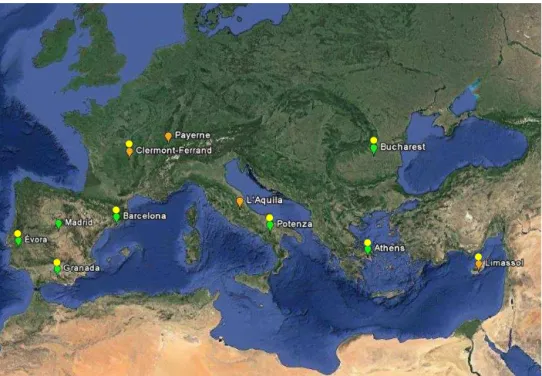
Eleven EARLINET stations around the Mediterranean Basin decided to participate to the exercise. From west to east (see Fig. 1 and Table 1):
– EV, Évora, Portugal (7.911◦W, 38.568◦N, 290 m a.s.l.) – MA, Madrid, Spain (3.730◦W, 45.450◦N, 663 m a.s.l.) – GR, Granada, Spain (3.610◦W, 37.160◦N, 680 m a.s.l.)
– BA, Barcelona, Spain (2.112◦E, 41.389◦N,
115 m a.s.l.)
– CL, Clermont-Ferrand, France (3.111◦E, 45.761◦N, 420 m a.s.l.)
– PA, Payerne, Switzerland (6.943◦E, 46.813◦N, 491 m a.s.l.)
– LA, L’Aquila, Italy (13.350◦E, 42.368◦N, 656 m a.s.l.)
– PO, Potenza, Italy (15.720◦E, 40.600◦N, 760 m a.s.l.)
– AT, Athens, Greece (23.780◦E, 37.960◦N, 212 m a.s.l.)
– BU, Bucharest, Romania (26.029◦E, 44.348◦N, 93 m a.s.l.)
– LM, Limassol, Cyprus (33.040◦E, 34.640◦N, 8 m a.s.l.) Seven stations operated an advanced lidar system (green la-bels in Fig. 1). Advanced lidars consist of at least three elastic wavelengths and two Raman wavelengths and allow aerosol typing and potentially microphysics retrieval. Four stations operated a Raman lidar system (orange labels in Fig. 1). Ra-man lidars consist of at least one elastic wavelength and one Raman wavelength and allow for the retrieval of the extinc-tion and the backscatter coefficients at one wavelength. Six stations also performed measurements of the linear particle depolarization ratio at one elastic wavelength. Even though PA performed the measurements during the whole campaign, their data are not presented in this work because of a lack of manpower to follow on with the analysis of their data.
Figure 1 also indicates the stations where a sun photome-ter is co-located. In total, eight stations have a co-located sun photometer, all of them being part of the Aerosol Robotic Network (AERONET) (Holben et al., 1998). Sun photome-ters allow for the retrieval of columnar values of paramephotome-ters such as the aerosol optical depth (AOD), the Ångström ex-ponent (AE), the single scattering albedo or the size distri-bution among others. Sun photometers are also a precious cooperative instrument to lidars for constraining elastic lidar inversions (Landulfo et al., 2003; Reba et al., 2010) and for microphysics retrieval (Wagner et al., 2013; Chaikovsky et al., 2015, Binietoglou et al., 2015).
Figure 1.Geographical position of the 11 stations that participated in the exercise. Green labels indicate advanced lidar systems; orange
labels indicate Raman lidar systems. Yellow circles indicate co-located sun photometers.
Table 1.Wavelengths and temporal resolution,1t, of the systems involved in the exercise.
Station Elastic wavelengths Raman wavelengths 1t
(nm) (nm) (s)
351 355 532 1064 382 387 393 408 607
Total //1 ⊥2 Total //1 ⊥2
EV x x x x x x 30
MA x x x x x 60
GR x x x x x x x 60
BA x x x x x x 60
CL x x x x 60
PA x x x 60
LA x x x 300
PO x x x x x x 60
AT x x x x x x x x 60
BU x x x x x x x 60 d/300 n3
LM x x x x 48
1// indicates the parallel polarization component with respect to the laser polarization.2⊥indicates the perpendicular polarization component with
respect to the laser polarization.3d indicates day and n night.
Freudenthaler et al., 2010; Molero et al., 2012, Wandinger et al., 2015). The data quality assurance also includes the inter-comparison of elastic and Raman retrieval algorithms of each individual station (Böckmann et al., 2004; Pappalardo et al., 2004b; Sicard et al., 2009). Based on well-defined common standards and internal quality tests, the routinely performed quality-assurance exercises of lidar systems and algorithms ensure that the data products provided by the individual sta-tions are homogeneous and continuously of highest possible
3 Real and near-real-time EARLINET single-calculus chain products
3.1 Presentation of the SCC
The single calculus chain (SCC) is the standard tool for the automatic analysis of EARLINET data. It has been de-signed to provide quality assured aerosol products (according to EARLINET quality assurance program) starting from the raw lidar time series. Two different levels of quality assured products are made available: pre-processed range corrected signals and aerosol extinction and/or backscatter coefficients. The SCC is highly configurable and flexible to assure the au-tomatic analysis of data coming from different type of lidars and, even for the same instrument, from different configu-rations. The SCC is composed by two independent but in-terconnected calculus modules: the EARLINET Lidar Pre-Processor (ELPP) module providing the pre-processed range corrected signals corrected for instrumental effects and the EARLINET Lidar Data Analyzer (ELDA) for the calcula-tion of the aerosol optical products from the ELPP outputs. All the input parameters needed for the lidar analysis are col-lected in a database and organized in terms of different lidar configurations. The modules ELPP and ELDA are automat-ically started and monitored by a dedicated daemon mod-ule when there are available input data not yet analyzed. The SCC is installed on a common server accessible by all EARLINET stations through a web interface which improves the user friendliness of the SCC. All the details of the SCC modules are described in this special issue (D’Amico at al., 2015a, b; Mattis et al., 2015).
For the exercise the SCC was configured to provide two kinds of aerosol products:
– SCC-1: pre-processed range-square corrected signal (RCS) in netcdf format generated by the ELPP mod-ule from the raw netcdf files submitted by each sta-tion. These products were generated in a full automatic way and in real time. At the same time the ELPP out-puts were stored, an email was automatically sent to the contact point of the originating station. This email gave a real-time feedback from the SCC about the pre-processing status and revealed to be extremely useful for real time fine tuning the SCC configuration of each individual system and of its associated products. – SCC-2: optical processed files generated by ELDA from
SCC-1 products. These products are netcdf files con-taining the profiles of the aerosol optical coefficients: backscatter in daytime (using SCC system configura-tions defined for daytime condition for each lidar) and backscatter and extinction in nighttime (using SCC sys-tem configurations defined for nighttime for each lidar). The lidar configuration (daytime or nighttime) to use for the SCC analysis of each raw lidar time series is selected automatically; time series containing Raman channels
are assigned to nighttime configuration while elastic-only data sets are analyzed using daytime configuration. The backscatter coefficients from elastic signals only (daytime) were retrieved with the iterative method (Di Girolamo et al., 1999; Masci, 1999), while the backscat-ter and extinction coefficients from the combination of elastic and Raman signals (nighttime) were retrieved with the method described in Ferrare et al. (1998). Both methods are implemented in the SCC (Mattis et al., 2015).
The netcdf files generated by ELDA are of two types: – b-files (b for backscatter) contain one profile of the
aerosol backscatter coefficient (m−1sr−1) derived from
the elastic backscatter signal only (daytime) or alterna-tively from the combination of an elastic and a Raman signal at the highest vertical resolution (nighttime). – e-files (e for extinction) contain profiles of aerosol
ex-tinction coefficient (m−1)and of aerosol backscatter
co-efficients at the same effective vertical resolution re-trieved independently from the combination of an elas-tic and a Raman signal without a priori assumptions on the existing relationship between them.
Both types of files include the profile of the statistical error associated to the variables they contain. More details about b- and e-files can be found in Pappalardo et al. (2014). 3.2 About the SCC product configurations
The configuration of the retrieval products delivered by the SCC is set online via a web interface in real time either by each station PI or by the SCC developers. To guarantee the uniformity of the results, the configuration of the prod-ucts generated during the exercise was set up by the SCC developers only. The configuration of a given product con-sists of defining a set of parameters (options) needed by ELPP and ELDA to perform the retrieval of that product. During the exercise, only three types of products were de-fined: the backscatter coefficient obtained with the elastic algorithm (daytime, b-files) and backscatter and extinction coefficients obtained with the Raman algorithm (nighttime, e-files). There are roughly two kinds of parameters to be ful-filled prior to the inversion: the general parameters (manda-tory, used for all product types) and the specific parameters (depend on the product type). The specific parameters, which are, for example, the inversion method, the error method, the value of the lidar ratio, etc., are not critical in the inversion procedure. For that reason, only the general parameters are presented next. An exhaustive list of the parameters needed for the retrieval products of the SCC can be found in this special issue (D’Amico et al., 2015b; Mattis et al., 2015).
Table 2.General parameters of the SCC product configuration set up for the exercise.
Module ELPP ELDA
Parameter Integration Vertical Min. Max. Detection limit Max. statistical Max. statistical
time resolution height height error (< 2 km) error (> 2 km)
Extinction Backscatter
Unit s m m m Mm−1 Mm−1sr−1 % %
EV 3600 60 250 15 000 5 0.1 10 10
MA 3600 60 250 15 000 5 0.1 10 10
GR 3600 60 500 15 000 5 0.1 10 10
BA 3600 60 250 15 000 5 0.1 10 10
CL 3600 60 250 15 000 5 0.1 10 10
LA 3600 60 250 15 000 5 0.1 10 10
PO 3600 60 250 15 000 5 0.1 10 10
AT 3600 60 250 12 000 5 0.1 10 10
BU 3600 60 250 15 000 5 0.1 10 10
LM 3600 60 250 15 000 5 0.1 10 10
vertical resolution of SCC-1 products (ELPP output) was fixed to 60 m, the highest spatial resolution of the 10 sys-tems involved in the exercise. The minimum and maximum heights represent the minimum and maximum altitude for the calculation of the product. The minimum height usually depends on the knowledge of the height of the full overlap, while the maximum height usually depends on the maximum range of useful signal or of acquisition. The last three pa-rameters are quite critical in the inversion procedure. They were all set to the same values for each of the 10 systems in order to standardize the delivered products in terms of absolute and statistical errors. The first one, called “detec-tion limit”, is one of the two criteria of the automated, itera-tive vertical smoothing algorithm of ELDA, which optimizes the vertical smoothing in each altitude bin. Detection limit is a backscatter, or an extinction absolute value, defining the product maximum absolute uncertainty allowed. In an initial step, the product is calculated with the maximum allowable vertical smoothing (i.e. resulting in a maximum effective ver-tical resolution of 500 and 2000 m below and above 2 km, respectively). In the following steps, the calculated absolute uncertainty is compared to the user-defined detection limit at each altitude bin. If the calculated absolute uncertainty stays below the user-defined detection limit, the smoothing win-dow is reduced by one bin and the whole process is repeated (see Sect. 3.5 of Mattis et al. (2015) for more details). Dur-ing the exercise, detection limit was set to 0.1 Mm−1sr−1for
the backscatter coefficients and to 5 Mm−1for the extinction
coefficient. No adjustment was allowed on those values to guarantee the same absolute uncertainty for all products, in-dependently of the system. Those values are lower than the initial target accuracies estimated in the GAW Report No. 178 (2008) of 0.5 Mm−1sr−1for the backscatter coefficients
and to 20 Mm−1for the extinction coefficient. The two other
parameters are the maximum allowed statistical errors be-low and above 2 km. The second criterion of the smoothing
algorithm is based on them and they are also used in the esti-mation of the calibration factor. In the smoothing algorithm, they fix the maximum values that the calculated statistical errors cannot exceed at each altitude bin. The iterative proce-dure is exactly the same as for the detection limit parameter. In the estimation of the calibration factor, they fix the maxi-mum values that the uncertainty of the calibration factor (cal-culated as the standard deviation of the signal in a certain alti-tude range; see Sect. 3.2.2 of Mattis et al. (2015) for more de-tails) cannot exceed. During the exercise, the statistical error thresholds for the low and the high range were set to the same value of 10 % for all products. Here again, no adjustment of those values was allowed to guarantee the same statisti-cal error for all products, independently of the system. The same order of magnitude (10 and 5 % for the backscatter re-trieved from elastic and Raman algorithm, respectively; 10 % for the extinction retrieved with the Raman algorithm) were estimated in the GAW Report No. 178 (2008). It is worth noting that relaxing the required uncertainties by increasing detection limit and/or the maximum allowed statistical errors would have led to a better (i.e. lower) effective vertical res-olution and thus to larger uncertainties of the final product. In turn, it might have possibly increased the number of suc-cessful SCC inversions (at the cost of degrading the error on the final product). However, in view of the good statistics of the SCC results (see next Section) we believe that the values of the detection limit and of the maximum allowed statistical errors chosen for the exercise are close to be optimal values and that increasing them would have not yielded much better results.
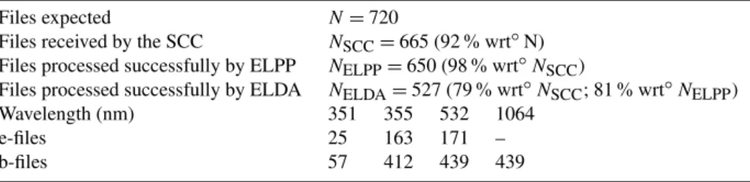
Table 3.Number of files at the different stages of the exercise and finally inverted by the SCC.
Files expected N=720
Files received by the SCC NSCC=665 (92 % wrt◦N)
Files processed successfully by ELPP NELPP=650 (98 % wrt◦NSCC)
Files processed successfully by ELDA NELDA=527 (79 % wrt◦NSCC; 81 % wrt◦NELPP)
Wavelength (nm) 351 355 532 1064
e-files 25 163 171 –
b-files 57 412 439 439
quality was not sufficient to pass ELPP quality control tests in two procedures: in applying the gluing algorithm and the dead time correction to photon-counting channels. The auto-matic procedure of gluing between analog and corresponding photon-counting signals consists of enhancing the detected dynamic range using the analog profile in the strong signal region and the photon-counting profile in the weak signal region. The gluing algorithm implemented in ELPP tries to find the optimal region where to combine the two signals per-forming a set of statistical and consistency tests (D’Amico et al., 2015b) to assure a reliable and stable combined signal. When such a region was not found, ELPP stopped the analy-sis and returned a specific error code. This is illustrated in the left panel of Fig. 2. On a total of 15 cases for which the raw data quality was not sufficient to pass ELPP quality control tests, 8 are the results of the gluing procedure, 6 refers to a problem in applying dead time correction to photon-counting channel and finally in 1 case there are format problems in the submitted raw netcdf file.
The number of SCC-2 profiles is 527, which represents 79 % of all submitted files (81 % of the files that passed ELPP). This percentage is quite large taking into account that no cloud screening was performed on lidar data. If we remove from the statistics the number of measurements iden-tified a posteriori as contaminated by clouds (see next para-graph), this percentage increases to 87 % (89 % of the files that passed ELPP). Most of the remaining 13 % (11 % with respect to the files that passed ELPP) that was not success-fully inverted by ELDA were due to low signal to noise ratio in at least one of the channel of the system. Even though the same number of stations run systems equipped with channels at 355 nm as visible ones (eight stations, see Table 1 ignor-ing PA), the number of b-files at 355 nm (412) is lower than at 532 nm (439). This can be explained by considering that the shorter is the wavelength the weaker is the contrast between aerosol and molecular contribution in lidar signals. As a con-sequence, in general, the retrieval of the aerosol backscatter coefficient is more problematic in the ultraviolet than in the visible or in the infrared spectral regions.
The reasons for which ELDA could not successfully per-form the optical processing of SCC-1 data are shown in the right panel of Fig. 2. There are a total of 123 cases. About half of them (60 cases, i.e. 49 % of them) refer to the auto-matic search of a reliable and stable region for the calibration
Figure 2.Number and frequency (in %) of the reasons for which either the pre-processing (ELPP, left) or the optical processing (ELDA,
right) could not derive a solution. The color legend indicates the error code.
exclusively since it always occurred at 355 nm) when there is a poor SNR or a strong contamination of clouds in the li-dar signals. Finally, in a non-negligible number of cases (21, 17 % of the cases for which ELDA could not successfully perform the optical processing) the reason has a computing origin. We have checked that in 17 cases, the profiles were contaminated by clouds and that in 4 cases (all of them in BA) the computing error was raised during the elastic inver-sion at 355 nm.
In summary, this statistical analysis allows for the identifi-cation of the most critical/sensitive products and steps of the optical processing module of the SCC. Throughout the exer-cise, with the exception of the cloud cases, ELDA is unable to finalize the inversion with the required accuracy in two main steps of the processing: in the search of a calibration interval and in the iterative procedure of the method used to invert the backscatter coefficient from elastic signals only. When the inversion is unsuccessful, it occurs mostly at 355 nm (94 % of the cases) and occasionally at 1064 nm (6 %). Among the unsuccessful inversions at 355 nm, 78 % of them occurred during the elastic inversion (daytime) and 22 % during the Raman inversion (nighttime). Low SNR of the 355 nm chan-nels, especially during daytime, emerges as a critical issue common to most of the systems involved in the exercise.
The SCC works as an online tool: regularly new SCC ver-sions including debugging and improvements are provided. When a new version is set up, the whole data set is in-verted again automatically, so that the number of retrieved profiles may change, and hopefully increase. Currently the cloud screening is under development as a separate tool and different approaches to perform a reliable and robust cloud screening at network level are in testing phase. Once imple-mented in the SCC, it will identify cloudy conditions before
the analysis which will allow us to gain computing time but not to increase the number of successful inversions.
4 Potential operationality of EARLINET
This section aims at demonstrating the potential operational-ity of EARLINET. After a brief description of the synoptic situation during the campaign, this demonstration is made by means of two examples: the monitoring of a Saharan dust in-trusion event and the evaluation of two dust transport models thanks to the variety and continuity of SCC products. The last subsection deals with the more general perspectives that this type of exercise offers to the atmospheric community.
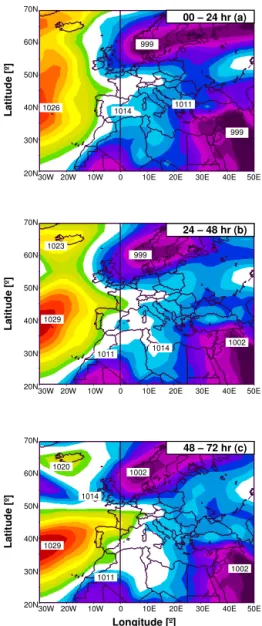
4.1 Synoptic situation during the 9–12 July 2012, measurement exercise
During the time window for the “GO” (2–12 July 2012) no strong levels of PM10 were predicted around the
Mediter-ranean Basin. On 3 July, a weak intrusion of Saharan dust was predicted for 5 July. The dust would come from the Libyan coasts towards south Italy and then would move east-ward. Maxima of dust concentration were expected on 6–7 July. The forecast on 4 July confirmed the intrusion of 5 July with two important changes: Spain would also be affected by the intrusion, and the event would strengthen starting on 8 July. The “GO” was fixed to Monday 9 July at 06:00 UT. The exercise ended on Thursday 12 July at 06:00 UT. The days of interest, 9, 10, 11 and 12 July, are hereinafter noted as J09, J10, J11 and J12, respectively.
00 – 24 hr (a) 70N
60N
50N
40N
30N
20N
30W 20W 10W 0 10E 20E 30E 40E 50E 1014
1011 999
24 – 48 hr (b) 70N
60N
50N
40N
30N
20N
30W 20W 10W 0 10E 20E 30E 40E 50E 999
1011 1014 1023
48 – 72 hr (c) 70N
60N
50N
40N
30N
20N
30W 20W 10W 0 10E 20E 30E 40E 50E 1014
1020
1011 1002
1002 1026
1029
1029
999
1002
Longitude [º]
L
ati
tu
d
e
[º
]
L
ati
tu
d
e
[º
]
L
ati
tu
d
e
[º
]
Figure 3.Mean synoptic situation from the NCEP/NCAR
Reanal-ysis project at(a)00–24,(b)24–48 and(f)48–72 h after the “GO”.
Purple and red colors represent low and high pressures, respectively.
Each map is a composite map from the NCEP/NCAR (Na-tional Centers for Environmental Prediction/Na(Na-tional Center for Atmospheric Research) Reanalysis project showing the mean sea level pressure for each period. The period is char-acterized by the presence of a stable Azores high and three low pressure systems centered over southern Norway, Saudi Arabia and Mali. A warm front associated with the low pres-sure system located over southern Norway produced unsta-ble weather over northern Europe and high temperatures and fair weather over western and central Europe. This situation generated generally clear skies above the northern part of the Mediterranean Basin, the region of interest, which persisted during the period as the Azores High moved slightly east-ward. Easterly winds were also predominant over Europe.
The Saharan dust intrusion forecasted to start on 5 July occurred indeed. It was a rather moderate event that did not affect all the stations involved in the 9–12 July measure-ment exercise as forecasted by dust transport models. The AERUS-GEO daily aerosol optical depth at 675 nm on J09, J10, J11 and J12 from the MSG/SEVIRI sensor is shown in Fig. 4a–d. Figure 4 shows how the dust, transported above northern Morocco, Algeria, and Tunisia, hits the southeastern coasts of Spain as well as southern Italy, disperses above the western Mediterranean Basin and moves slowly eastwards. It also shows the intensity decrease of the dust event from J09 until J12. It is not clear if the dust plume reaches Greece and Romania. According to Fig. 4 the only stations that are very likely to have been hit by the event are GR, LA and PO. The maximum dust concentration forecast by the BSC-DREAM8b model was∼170–180 µg m−3over LA and PO
on J09 at 12:00 UT and over GR on J12 at 12:00 UT (after the exercise ended).
In addition to mineral dust, fires are also frequent around the Mediterranean Basin at this period of the year. The fire overlays from the MODIS sensor onboard Aqua and Terra satellites are shown in Fig. 4e–h. Many fires are present on the northern coast of Algeria, in Sicily and in southern Italy. The fire smoke could be mixed with the dust plume which is visible on MODIS images. A series of fires are also present from west to east between the countries of the ex-Yugoslavia and southern Romania.
4.2 Example 1: monitoring of a Saharan dust intrusion event
This section aims at illustrating how the SCC products that EARLINET is able to provide in real and near-real time (un-der some given circumstances) can be used to monitor not only a special event (here a Saharan dust intrusion event) but more generally the aerosol 4-D (spatial and temporal) char-acterization. A more comprehensive analysis of the dust mi-crophysics during the operationality exercise can be found in Granados-Muñoz et al. (2015). For that reason, the emphasis is put more on the SCC-1 and SCC-2 products than on the proper monitoring of the dust event.
4.2.1 Time–height series of the semi-attenuated backscatter coefficient (not a SCC product) Time–height series, also called quicklooks, of the attenuated backscatter coefficient not corrected for the total transmissiv-ity are shown in Fig. 5 for EV, BA and BU at 1064 nm. The attenuated backscatter not corrected for the total transmissiv-ity was calculated by fitting the RCS to the molecular slope in an aerosol-free region. To do so, the RCS,P (z), at
alti-tudezwas fitted to the profile of the molecular backscatter
coefficient,βm(z), in an aerosol-free region centered around
a reference altitude,zref. The attenuated backscatter not
(a) (e)
(b) (f)
(c) (g)
(d) (h)
GR
1 0.8 0.6 0.4 0.2 0
A
OD
675
EV MA BA CL PA
LA PO
BU
AT LM
Figure 4.MSG/SEVIRI AERUS-GEO daily AOD at 675 nm on(a)J09,(b)J10,(c)J11 and (d) J12. Aqua/ and Terra/MODIS fire overlays
on(e)J09,(f)J10,(g)J11 and(h)J12 from https://earthdata.nasa.gov/labs/worldview/. The legend of(d)applies for(a),(b)and(c).
ated backscatter,βatt, are related through:
βatt−uncorr(z)=
βT(z)TT2(z)
TT2(zref)
= βatt(z)
TT2(zref), (1)
where βT and TT refer to the total backscatter coefficient
and the total transmissivity, respectively. The thickness of the fitting region was fixed to 1 km around the reference al-titude which was selected within the range 5.5–7.5 km de-pending on the aerosol stratification. The quicklooks shown here were calculated from the raw signals contained in the in-put netcdf files received by the SCC. Quicklooks are not yet a standard product of the SCC, but their representation gives an excellent overview of the aerosol load vertical distribution and temporal evolution at each station.
Three very different situations are observed in Fig. 5. In EV, almost no clouds are observed during the whole event. The temporal evolution of βatt−uncorr has a marked diurnal
cycle clearly correlated with that of the planetary boundary layer (PBL). Hardly any lofted layers are observed above the PBL. In BA,βatt−uncorr is quite strong in the first
kilo-meter where the PBL top is usually detected (Sicard et al., 2011). In the quicklook, many layers of different intensities are observed in the troposphere and up to 5 km. The aerosol stratification in BU is also complex. The PBL formation is clearly visible every morning after 06:00–07:00 UT. At all
times, aerosol layers are observed in the troposphere and up to 6 km.
4.2.2 RCS profiles at several wavelengths (SCC-1 products)
The products from ELPP are illustrated by means of the RCS profiles at 355 and 532 nm on J11 which are shown in Fig. 6 for the same stations as in Fig. 5. The RCS units are arbi-trary units. The x axis limit of Fig. 6 has been optimized
to highlight the layers with aerosols. The regions where the RCS profiles exceed the selectedxaxis limit are usually
(a)
(b)
(c)
J09
J10
J11 J12
Évora
Barcelona
Bucharest
Figure 5.Quicklooks of the attenuated backscatter not corrected for
the total transmissivity [a. u.] at 1064 nm in(a)Évora,(b)Barcelona
and(c)Bucharest. The white vertical lines indicate a change in the
date. The attenuated backscatter is not a product of the SCC.
extremely useful for validation of and/or assimilation in air quality and climate models (see Sect. 4.4).
4.2.3 Backscatter coefficient profiles at several wavelengths (SCC-2 products)
The ELDA module of the SCC provides inversions of the aerosol optical properties. During daytime all elastic wave-lengths are inverted by means of the iterative method (Di Girolamo et al., 1999; Masci, 1999; Mattis et al., 2015). Fig-ures 7 and 8 show the temporal evolution of the profiles of the backscatter coefficient at all stations with at least two wavelengths on J10. Figure 7 reports the results at the Iberian stations and Fig. 8 at the central and eastern European sta-tions. All the profiles are reported as a function of height above mean sea level. This is the reason why the different stations present profiles starting at different heights in agree-ment with their respective altitudes above sea level. Some inversions are missing in the middle of the day in MA, BA,
1 2 0 1 2 3 4 5 6 A lt it u d e as l [ km ]
1 2 1 2 1 2 1 2 1 2 1 2 1 2 1 2 1 2 1 2 1 2
RSCS [a. u.]1 2 1 2 1 2 1 2 1 2 1 2 1 2 1 2 1 2 1 2 1 2 1 2 22 23 21 20 19 18 17 16 15 14 13 12 11 10 09 08 07 06 05 04 03 02 01 00 (a) 1 2 0 1 2 3 4 5 6 A lt it u d e as l [ km ]
1 2 1 2 1 2 1 2 1 2 1 2 1 2 1 2 1 2 1 2 1 2
RSCS [a. u.]1 2 1 2 1 2 1 2 1 2 1 2 1 2 1 2 1 2 1 2 1 2 1 2 22 23 21 20 19 18 17 16 15 14 13 12 11 10 09 08 07 06 05 04 03 02 01 00 (b) 1 2 0 1 2 3 4 5 6 A lt it u d e as l [ km ]
1 2 1 2 1 2 1 2 1 2 1 2 1 2 1 2 1 2 1 2 1 2
RCS [a. u.]1 2 1 2 1 2 1 2 1 2 1 2 1 2 1 2 1 2 1 2 1 2 1 2 22 23 21 20 19 18 17 16 15 14 13 12 11 10 09 08 07 06 05 04 03 02 01 00 (c) Barcelona Évora Bucharest
Figure 6.24 h evolution of the hourly RCS profiles (SCC-1 product)
at 355 (blue lines) and 532 nm (green lines) on J11 in(a)Évora, (b)Barcelona and(c)Bucharest. The numbers in the top of the plots
indicate the time in UT. The horizontal black lines represent the station’s altitude asl.
PO, BU and LM. In MA all the daytime missing inversions are due to a not-converging iterative procedure during the elastic inversion at 355 nm. We manually checked that no cloud was present. The BA system presents the peculiarity of pointing not at zenith but at 52◦ off zenith. This
pecu-liarity is a clear disadvantage since the optical thickness in the atmospheric path is 11cos
(52◦)cos(52◦)∼1.65 larger
2 4 0 2 4 6 A lt it u d e as l [ km ]
2 4 2 4 2 4 2 4 2 4 2 4 2 4 2 4 2 4 2 4 2 4 2 4 2 4 2 4 2 4 2 4 2 4 2 4 2 4 2 4 2 4 2 4 2 4 00 01 02 03 04 05 06 07 08 09 10 11 12 13 14 15 16 17 18 19 20 21 22 23
Évora 2 4 0 2 4 6 A lt it u d e as l [ km ]
2 4 2 4 2 4 2 4 2 4 2 4 2 4 2 4 2 4 2 4 2 4 2 4 2 4 2 4 2 4 2 4 2 4 2 4 2 4 2 4 2 4 2 4 2 4 00 01 02 03 04 05 06 07 08 09 10 11 12 13 14 15 16 17 18 19 20 21 22 23
Madrid 2 4 0 2 4 6 A lt it u d e as l [ km ]
2 4 2 4 2 4 2 4 2 4 2 4 2 4 2 4 2 4 2 4 2 4 2 4 2 4 2 4 2 4 2 4 2 4 2 4 2 4 2 4 2 4 2 4 2 4 00 01 02 03 04 05 06 07 08 09 10 11 12 13 14 15 16 17 18 19 20 21 22 23
Granada 2 4 0 2 4 6 A lt it u d e as l [ km ]
2 4 2 4 2 4 2 4 2 4 2 4 2 4 2 4 2 4 2 4 2 4 2 4 2 4 2 4 2 4 2 4 2 4 2 4 2 4 2 4 2 4 2 4 2 4 00 01 02 03 04 05 06 07 08 09 10 11 12 13 14 15 16 17 18 19 20 21 22 23
Barcelona
Bck coef [Mm-1·sr-1]
Figure 7.Time series of elastic-inverted backscatter coefficient
pro-files (SCC-2 product) on J10 at 355 (blue), 532 nm (green) and 1064 nm (red) at the Iberian stations ordered west to east. The num-bers below the top axis indicate the time in UT. The horizontal black lines represent the station’s altitude asl.
performed. It is worth noting that even in the presence of low clouds the inversion can be successful (see BA plot at 06:00 and 10:00–13:00 UT and also BU at 02:00–04:00 UT). Be-cause no cloud-screening procedure is implemented yet in the SCC, if the low clouds are optically thin, ELDA is able to find a calibration interval (above them) and to perform the inversion. However such inversions are not yet useful for sci-ence because ELDA is not yet made to handle clouds. In PO, in 8 cases, among which 1 of them was identified a posteri-ori as contaminated by clouds, ELDA could not find a cali-bration interval. In BU, the missing inversions at 07:00 and 08:00 UT were due to the not-converging iterative procedure. We verified a posteriori that the three-afternoon missing in-versions in BU contained clouds that can be actually seen in Fig. 5c. In LM, no measurements were performed between 09:00 and 14:00 UT on J10 because of technical problems with the laser transmitter. It is worth noting that the SCC is configured so that it returns the full set of products of a de-fined system configuration only if the inversion of all prod-ucts is performed successfully (pre-processing and optical processing). If a single product is not retrieved successfully, no inversion at all is delivered. It is a way to guarantee a high quality of all the products defined in a system configuration and delivered by the SCC. The drawback is that if the quality of the raw data is not sufficient for the analysis, the raw data do not pass the quality control tests of the analysis algorithms
2 4 0 2 4 6 A lt it u d e as l [ km ]
2 4 2 4 2 4 2 4 2 4 2 4 2 4 2 4 2 4 2 4 2 4 2 4 2 4 2 4 2 4 2 4 2 4 2 4 2 4 2 4 2 4 2 4 2 4 00 01 02 03 04 05 06 07 08 09 10 11 12 13 14 15 16 17 18 19 20 21 22 23
Potenza 4 8 0 2 4 6 A lt it u d e as l [ km ]
4 8 4 8 4 8 4 8 4 8 4 8 4 8 4 8 4 8 4 8 4 8 4 8 4 8 4 8 4 8 4 8 4 8 4 8 4 8 4 8 4 8 4 8 4 8 00 01 02 03 04 05 06 07 08 09 10 11 12 13 14 15 16 17 18 19 20 21 22 23
Athens 2 4 0 2 4 6 A lt it u d e as l [ km ]
2 4 2 4 2 4 2 4 2 4 2 4 2 4 2 4 2 4 2 4 2 4 2 4 2 4 2 4 2 4 2 4 2 4 2 4 2 4 2 4 2 4 2 4 2 4 00 01 02 03 04 05 06 07 08 09 10 11 12 13 14 15 16 17 18 19 20 21 22 23
Bucharest 2 4 0 2 4 6 A lt it u d e as l [ km ]
2 4 2 4 2 4 2 4 2 4 2 4 2 4 2 4 2 4 2 4 2 4 2 4 2 4 2 4 2 4 2 4 2 4 2 4 2 4 2 4 2 4 2 4 2 4 00 01 02 03 04 05 06 07 08 09 10 11 12 13 14 15 16 17 18 19 20 21 22 23
Limassol
Bck coef [Mm-1·sr-1]
Figure 8.Idem as Fig. 7 at the central and eastern European stations
ordered west to east.
and the SCC does not return any result for the corresponding measurement. During nighttime the SNR is higher than dur-ing daytime, and the inversion (mostly at 355 or at 532 nm) is statistically more successful during nighttime than during daytime, especially around the hours when the sun is close to zenith (Mattis et al., 2015).
Except near the surface where none of the systems is corrected for the incomplete overlap and for obvious cloudy cases, the backscatter coefficient generally does not exceed 3 Mm−1sr−1. In AT, the backscatter coefficient at
355 nm is higher, reaching regularly 6 Mm−1sr−1in the
tro-pospheric layers. Except in EV where the troposphere is par-ticularly clean during the whole period, tropospheric aerosols are present generally between 2 and 5 km and sometimes up to 6 km (in PO). In GR, the aerosol layer above 2–3 km has a very low spectral dependency (especially visible between the profiles at 355 and 532 nm) which indicates the presence of mineral dust. This low spectral dependency is also observed on the profiles of PO above 4 km in the early hours of J10, which also confirms the presence of mineral dust but at a higher altitude compared to GR.
4.2.4 Extinction coefficient profiles at several wavelengths (SCC-2 products)
sta-1 2 0 2 4 6
A
lt
it
u
d
e
as
l [
km
]
1 2 1 2 1 2 1 2 1 2 1 2 1 2 1 2 1 2 1 2 1 2 18 19 20 21 22 23 00 01 02 03 04 05
(x 102)
Granada, J09-J10
1 2 0 2 4 6
A
lt
it
u
d
e
as
l [
km
]
1 2 1 2 1 2 1 2 1 2 1 2 1 2 1 2 1 2 1 2 1 2 18 19 20 21 22 23 00 01 02 03 04 05
(x 102)
Barcelona, J09-J10
1 2 0 2 4 6
A
lt
it
u
d
e
as
l [
km
]
1 2 1 2 1 2 1 2 1 2 1 2 1 2 1 2 1 2 1 2 1 2 18 19 20 21 22 23 00 01 02 03 04 05
(x 102)
Potenza, J10-J11
1 2 0 2 4 6
A
lt
it
u
d
e
as
l [
km
]
1 2 1 2 1 2 1 2 1 2 1 2 1 2 1 2 1 2 1 2 1 2 18 19 20 21 22 23 00 01 02 03 04 05
(x 102)
Bucharest, J10-J11
Ext coef [Mm-1]
Figure 9.Time series of Raman-inverted extinction coefficient
pro-files (SCC-2 product) at 355 (blue) and 532 nm (green). The num-bers below the top axis indicate the time in UT. The horizontal black lines represent the station’s altitude asl.
tions of the Iberian Peninsula (GR and BA on the night J09– J10) and at two stations of central and eastern Europe (PO and BU on the night J10–J11). The plots at PO and BU are shown 24 h after the selected night at GR and BA in order to maximize the probability of presence of mineral dust in the profiles (see Fig. 4). As it can be seen in Fig. 9, the tem-poral continuity of the retrieved profiles reveals the correct functioning of the SCC in nighttime conditions.
All extinction profiles stay generally below 200 Mm−1.
Low spectral dependency between both profiles at 355 and at 532 nm is observed at GR above 2 km and at PO in the whole profile, and indicates the presence of mineral dust at both sta-tions. In BA, the profiles at both wavelengths are quite differ-ent and suggest differdiffer-ent signal levels: the large oscillations at 355 nm reflect lower SNR compared to 532 nm. In BU, the extinction coefficient is almost twice as large at 355 nm than at 532 nm. The large spectral dependency observed on the extinction coefficient in both BA and BU is consistent with the high AE found on the AERONET data (1.4–1.7 in
BA and 1–1.2 in BU; Granados-Muñoz et al., 2015). In BU, an aerosol layer is clearly visible up to 2 km and another one up to 5–6 km, reaching peak values at heights between 3 and 4 km. Those vertical profiles of optical properties are in agreement with the microphysical retrievals presented in Granados-Muñoz et al. (2015) who found a strong contribu-tion of non-spherical coarse particles in the lofted layers on J09 in GR, and a strong contribution of fine particles in the lofted layers on J11 in BU.
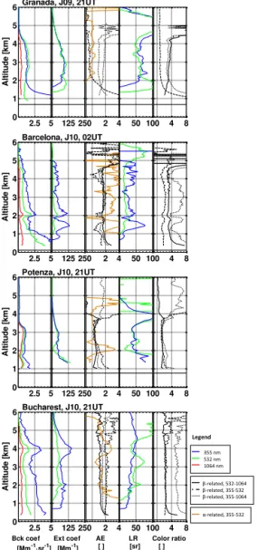
4.2.5 Parameters derived from the SCC-2 products The Raman and the multi-wavelength capabilities of the ad-vanced systems allow for the retrieval of derived products such as
– the backscatter-related AE between the wavelengths (355, 532 nm; AE355−532), (532, 1064 nm; AE532−1064)
and (355, 1064 nm; AE355−1064)
– the extinction-related AE between the wavelengths (355, 532 nm)
– the lidar ratios (LR), the extinction-to-backscatter ratio, at 355 (LR355)and at 532 nm (LR532)
– the color ratios, the ratio of the backscatter coefficients, between the wavelengths (355, 532 nm; CR355−532),
(532, 1064 nm; CR532−1064) and (355, 1064 nm;
CR355−1064).
2.5 5 0 1 2 3 4 5 6 A lt it u d e [k m ]
125 250 2 4
AE LR 50 100Color ratio4 8
Granada, J09, 21UT
2.5 5 0 1 2 3 4 5 6 A lt it u d e [k m ]
125 250 2 4 50 100 4 8 Barcelona, J10, 02UT
2.5 5 0 1 2 3 4 5 6 A lt it u d e [k m ]
125 250 2 4 50 100 4 8 Potenza, J10, 21UT
2.5 5 0 1 2 3 4 5 6 Bck coef [Mm-1·sr-1]
A lt it u d e [k m ] 125 250 Ext coef [Mm-1]
2 4 AE [ ] 50 100 LR [sr] 4 8 Color ratio [ ]
Bucharest, J10, 21UT
β-related, 532-1064 β-related, 355-532 β-related, 355-1064 355 nm 532 nm 1064 nm
α-related, 355-532 Legend
Figure 10. All optical products (SCC-2 direct and derived
prod-ucts) at a selected time. The legend is the same for all the plots and is reported in the bottom right corner. The horizontal black lines represent the station’s altitude asl.
the NOAA-ARL (National Oceanic and Atmospheric Ad-ministration – Air Resources Laboratory). They are shown in Fig. 11.
The backscatter and extinction coefficients retrieved by the SCC were compared to the manual inversions provided by each group. In GR, one difference appears between the SCC profiles and the manual inversions provided by the Granada group (not shown): the SCC profile of the backscatter coef-ficient at 1064 nm is lower (by a roughly constant value of
−1.2 to−1.0 Mm−1sr−1)with respect to the manual
inver-sions. This discrepancy is mainly due to different approaches used to calibrate the backscatter coefficient at 1064 nm. The SCC calibration is made following the procedure provided by Mattis at al. (2015) constraining, within the calibration range, the aerosol backscatter coefficient to a fixed climatological
value. On the other hand, the calibration of the manually inverted backscatter coefficient at 1064 nm is made accord-ing to Engelmann et al. (2015). In particular, the informa-tion available at other wavelengths (355, and 532 nm in this case) is used to constrain the aerosol backscatter reference at 1064 nm. This approach cannot be used by the SCC be-cause, in the current version, it does not implement retrieval procedures combining aerosol products calculated at differ-ent wavelengths. In the framework of the ongoing ACTRIS-2 project, EARLINET is working to implement such ad-vanced analysis procedures in the SCC and also to set up a multi-wavelength post-retrieval quality check for both man-ual and SCC inversions. In BA, the agreement between SCC and manual retrievals is good, even though larger variations, probably due to different vertical resolutions, are observed on the manual retrievals. In PO, the agreement between SCC and manual retrievals is very good. Only one significant dis-crepancy, which might also be due to different vertical reso-lutions, is observed on the extinction coefficient at 532 nm in the range 1.7–2.5 km which is in average around 15 Mm−1
for the SCC and 35 Mm−1for the manual inversion. Finally,
in BU the agreement between SCC and manual retrievals is very good. No significant differences are observed. It is worth noting that D’Amico et al. (2015b), who performed systematic comparisons between SCC and manual retrievals, show that there is no climatological bias between both re-trievals.
As far as the aerosol 4-D characterization is concerned, the analysis of Figs. 10 and 11 gives an insight about the possible aerosol type observed at each site. In GR, two lay-ers are detected: one below 2 km and another one above up to 4–4.5 km. Above 2 km the extinction coefficient profiles at 355 and at 532 nm overlap, which results in an extinction-related AE close to 0. This low value of the extinction-extinction-related AE indicates the presence of large particles such as min-eral dust. The back trajectories at 2.5 and 4 km originate along the coasts of Morocco where dust is detected on the MSG/SEVIRI AOD maps (Fig. 4). The back trajectories ar-riving in GR at 1500 m seems to have a north Atlantic ori-gin. Except for a peak at 80 sr, LR355varies between 55 and
70 sr while LR532varies between 45 and 65 sr between 2 and
4 km. The values found for the lidar ratios and the extinction-related AE are in agreement with previous observations of Saharan dust in GR (Guerrero-Rascado et al., 2008, 2009; Córdoba-Jabonero et al., 2011). In BA, several layers are ob-served up to∼4.5 km. The backscatter-related AE are quite
variable from one pair of wavelengths to another, while the extinction-related AE is often larger than 2, a value quite larger than the mean summer value of 0.82 given by Sicard et al. (2011). LR355varies between 30 and 45 sr while LR532
ar-(a)
(b)
(c)
(d)
Granada
Barcelona
Potenza
Bucharest
Figure 11.HYSPLIT 4-day back trajectories(a)in Granada on J09 at 21:00 UT,(b)in Barcelona on J10 at 02:00 UT,(c)in Potenza on J10
at 21:00 UT and(d)in Bucharest on J10 at 21:00 UT.
riving at 2.5 and 4 km have a clear origin over the Atlantic Ocean. In spite of the large variability of the aerosol intensive parameters derived from the SCC-2 products, the results ob-tained (large extinction-related AE and low LR532)together
with the back trajectories indicate that marine aerosols are likely mixed with local polluted particles. From the backscat-ter coefficient profiles in PO, three aerosol layers stand out: one up to 1.7 km, a second one between 1.7 and 2.5 km and another one between 2.5 and 3.5 km. One observes that the higher the aerosol layer, the lower the spectral dependency. This behavior is well reproduced on the backscatter-related AE that decrease with increasing height and that are simi-lar and lower than 1 at almost all heights. In the uppermost layer, (2.5–3.5 km) all AEs are lesser than 0.5. The lidar ra-tios in the same interval range are similar and vary between 40 and 55 sr. Those results (low AE; 40 < LR < 55 sr) reveal the presence of mineral dust in the aerosol layer between 2.5 and 3.5 km, a conclusion that is confirmed by the back trajectories arriving in PO at 3 km (Fig. 11c) which origi-nate along the coasts of Morocco where dust is present (see the MSG/SEVIRI AOD maps in Fig. 4). These results are in agreement with previous studies on Saharan dust
obser-vations over PO by Mona et al. (2006, 2014). Over about 6 years of Raman measurements LR532 for dust (pure and
mixed situations) is found to be in the range 40–70 sr and typ-ically increases with decreasing AE (Mona et al., 2014). In BU, two main layers are visible on the backscatter coefficient profiles: one between 1.0 and 2.5 km and another one cen-tered around 4 km. A clear spectral dependency arises from the optical coefficients resulting in Ångström exponents rela-tively high. The lidar ratios are slightly different between one layer and the other: LR355 ∼30 sr and LR532∼40 sr in the
range interval 2–3 km while LR355∼45 sr and LR532∼38 sr
in the layer centered around 4 km. All three back trajectories arriving in BU at 1.5, 2.5 and 4 km come from the same direc-tion: west–southwest. According to Burton el al. (2012) the combination of AE532−1064∼1.1 (which represents a color
ratio 532/1064 nm near 2) and LR532∼40 sr (at 2–3 km) and
in BU (Nicolae et al., 2013), in which fresh and aged smoke particles are distinguished by means of their Ångström expo-nents and the ratio of their lidar ratios (LR532/LR355). Also
Granados-Muñoz et al. (2015) found that the aerosol size dis-tribution in BU was dominated by small particles, especially on J11.
4.3 Example 2: evaluation of dust transport models Another outcome of the operationality exercise is the evalu-ation of aerosol transport model. Since the western and cen-tral Mediterranean Basin was hit by an intrusion of Saharan dust, the exercise is an excellent tool for examining the per-formance of dust transport models. This section aims at il-lustrating how SCC-2 products, namely the vertical profiles of extinction coefficient, can be used to examine the perfor-mance of dust transport models to predict the 4-D evolution of mineral dust during a dust intrusion event. Literature is available on the subject (Gobbi et al., 2013; Mona et al., 2014; Binietoglou et al., 2015, among others), so that, again, the emphasis is put more on the potential of SCC-2 prod-ucts for the evaluation of aerosol transport models than on the proper evaluation of the selected dust transport models during the exercise.
Two models participated in this evaluation: BSC DREAM8b v2 (Pérez et al., 2006a, b; Basart et al., 2012) and NMMB/BSC-DUST (Nonhydrostatic Multiscale Me-teorological Model on the B grid/Barcelona Supercom-puting Center – Dust; Janjic et al., 2011; Pérez et al., 2011). Both models are developed and operated at the Barcelona Supercomputing Center (BSC), Spain. Table 4 summarizes the main parameters used in the configura-tion of the models. More details about their physical parametrizations (source mask and emission and deposition schemes) can be found at http://www.bsc.es/earth-sciences/ mineral-dust-forecast-system. The only operational product from the models that can be compared directly to one of the SCC products is the extinction coefficient at 550 nm. The modeled extinction values at 550 nm are directly compared with the SCC extinction values at 532 nm because of the wavelength proximity and the low spectral extinction depen-dence of mineral dust (see Sect. 4.2). In order to avoid mak-ing any hypothesis on the relationship between lidar-derived backscatter and extinction coefficients, only extinction coef-ficients retrieved from the combination of elastic and Raman signals (nighttime, e-files) are used. The vertical resolution of both dust models is much coarser than the lidar vertical resolution. In order to evaluate the models’ capability to re-produce the vertical distribution of the dust extinction coeffi-cient, the original lidar vertical resolution is degraded to the resolution of the modeled profiles. For the horizontal resolu-tion, the lidar data can be considered to be punctual observa-tions, while the models represent uniform pixels of 0.3/0.25◦
resolution (∼33/25 km) for
BSC-DREAM8b/NNMB/BSC-DUST, respectively. The temporal resolution is also different:
while the models provide instantaneous profiles (every 1 h for BSC-DREAM8b and every 3 h for NNMB/BSC-DUST), the lidar profiles are averaged over 1 h. Here we have com-pared each modeled profile at timet with the lidar-derived
profile averaged overt+1 h. Finally, the comparison
exer-cise between modeled and observed profiles of the dust ex-tinction coefficient is performed only in the free troposphere. The lower limit of the comparison range was fixed to 2 km. This choice is related to the fact that both models provide only the dust component of the aerosol content, while the li-dars measure the whole aerosol content. Both quantities are usually quite different in the PBL. The upper limit was fixed to 7 km since no dust was detected higher than 7 km neither in Granada, nor in Potenza.
The comparison is performed at the two sites where the dust was detected and clearly identified: Granada and Potenza. Model and observation comparisons can be per-formed for many different quantities and in many different ways (Gobbi et al., 2013; Mona et al., 2014; Binietoglou et al., 2015; Granados-Muñoz et al., 2015, among others). In order to avoid applying additional algorithms on the pro-files, we discarded the comparison of structural parameters, like the center of mass or the dust layer thickness (which, in addition, are not SCC products). We focused the com-parison on the similarities of consecutive, individual profiles of the dust extinction coefficient. For each pair of individ-ual profiles (model, observation) we calculated the following two statistical indicators: the correlation coefficient,r, and
the fractional bias,FB. The linear correlation coefficient is a
measure of the models’ capability to reproduce the shape of the aerosol profile. The fractional bias is a normalized mea-sure of the mean bias and indicates only systematic errors which lead to an under/overestimation of the measured val-ues.