INTRODUCTION
T
he Azores Environment and Sea Agency through its Regional Department of Land Management and Water Resources, together with the Agency of Land Management of the Autonomous Government of The Canary Islands and the Regional Cabinet of Transport and Social Equipment of the Autonomous Government of Madeira carry on the project “Sustainable Management of the Social, Economic and Ecological Development of the coastal areas of Macaronesia within the community initiative INTERREG III B 2000-2006, Açores-Madeira-Canary Islands, which has been designated as LITOSOST.The LITOSOST project aims at achieving land management of a coastal area which focuses on reduc-ing the urban and infra-structural pressure and regenerating, recover-ing and convertrecover-ing it for public fruition (UNESCO, 1997; Mota et al.,
2004; DROTRH/SRAM, 2006; MAOTDR, 2006).
The general goal of the project consists on stimulating practices to the sustainable management of the coastal areas of the Azores, Madeira and Canary Islands. As specific objec-tives, the following stand out:
to strengthen the cooperation between the Macaronesia authorities; to identify the problems and the com-mon potential of the coastal areas of the islands;
to train human resources: Management and Preservation of Resources;
to contribute for the improvement of the state of the coastal ecosystems of the EU islands.
The intervention area of this pro-ject in the Autonomous Region of the Azores, are the islands Santa Maria, Graciosa, Flores and Corvo, the main goal consists in the elaboration of the Coastal Zone Management Plans. MATERIALS AND METHODS THE COASTAL ZONE MANAGEMENT PLAN OF SANTA MARIA AS A
CHANCE FOR FOSSILIFEROUS OUTCROPS MANAGEMENT Calado, H. 1, 2, S.P. Ávila 3, 4, 5& P. Madeira 3, 4
1Secção de Geografia, Departamento de Biologia, Universidade dos Açores, Rua Mãe de Deus,
9501-855 Ponta Delgada, Azores, PORTUGAL
2CIBIO, Centro de Investigação em Biodiversidade e Recursos Genéticos - Pólo Açores,
Departamento de Biologia, Universidade dos Açores, Rua da Mãe de Deus, Apartado 1422, 9501-855 Ponta Delgada, Azores, PORTUGAL
3MPB, Marine PalaeoBiogeography Working Group of the University of Azores, Departamento
de Biologia, Universidade dos Açores, 9501-855 Ponta Delgada, Azores, PORTUGAL, e-mail: tamissa@hotmail.com
4 Departamento de Biologia, Universidade dos Açores, Rua Mãe de Deus, 9501-855 Ponta
Delgada, Azores, PORTUGAL
Definition of Coastal Zone Management Plan
The Coastal Zone Management Plans (CZMP) are considered as Special Land Management Plans, as mentioned in the Law-Decree nr 380/99 dated from September, 22nd, altered and re-published by the Law-Decree 310/2003, dated from December, 10th, which establishes the juridical regime of the Land Management Instruments/Tools. It has been adapted to the Azores Region through the Regional Legislative Decree nr 14/2004, dated from May, 23rd, altered and re-pub-lished by the Regional Legislative Decree nr 24/2003/A, dated from May, 12th. These plans constitute a Governmental extra means of
inter-vention and aim at achieving objec-tives of national interest with spatial repercussions, establishing safeguard regimes for resources and natural values, ensuring the permanence of systems which are fundamental to the sustainable land use.
Intervention Area
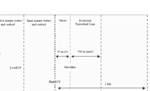
The definition of the intervention area for the CZMP is presented in the areas defined in Fig. 1. When the beach stretches beyond the estab-lished width, the bank will be extend-ed according to the limits definextend-ed in the CZMP. In the process of design-ing this area, some practical aspects must be pointed out:
a) the sea limit representing the Protection Sea Zone of Santa
FIGURE 1. Intervention (operational) and Study Area of the CZMP. LowEST – Lowest level of equinox spring tide. HighEST – highest level of equinox spring tide.
Maria Island has been found by interpolating the bathymet-ric of the -50m and – 20 m; b) the island’s limit, which equals
the sea level, as been taken as the land limit of the Protection Sea Zone of Santa Maria Island, due to lack of informa-tion concerning the highest level of high tide of the equinox spring tide;
c) coastline has been assumed to meet the sea level, as shown in the vectorial information, of the Geographic Institute. In order to simplify the graphic representation, the AI is shown in two distinctive units as in Fig. 2:
a) Protection Sea Zone, between the bathymetric of -30m and the coastline;
b) The coastal strip 500 metres
wide, measured from the coastline inland.
Coastal Zone Management Plan main Goals
The CZMP aims at integrating the socio-economic development with environmental protection and improvement, urban planning and management, besides protecting the coast, promoting the communication between institutions and public par-ticipation. The environmental plan-ning is based on a set of guidelines, in order to achieve a holistic manage-ment of all resources, regardless their nature – economic, social, cultural or natural – ensuring, thus, a sustainable development (Beller et al., 1990).
According to the Law-Decree nr 309/93, dated from September, 2nd, changed by the Law-Decree nr
FIGURE 2. Limits of the intervention area of Santa Maria Island. At yellow, the pro-tected terrestrial zone; at blue, the bathymetry of 30m depth.
218/94, dated from August, 20th, and by the Law-Decree nr 113/97, dated from May, 10th, and still in accor-dance with the adaptation done con-cerning the Autonomous Region of the Azores, in the Regional legislative Decree nr 18/98/A, dated from November, 9th, the objectives of the CZMP are as follow:
a) to rank the different uses and practices;
b) to classify the beaches and reg-ulate the bathing use;
c) to value the beaches consid-ered as strategic, due to envi-ronmental or tourist reasons; d) to lead the development of specific activities of the coastal area;
e) to preserve nature.
The fulfilment of the guide-lines regarding the interventions on the coastal area implies that a set of principles is observed during the elaboration of the CZMP. The princi-ples established by law, to be observed during the elaboration of the plan are the following:
a) protection of the biophysical integrity of the space;
b) valuation of the coastal resources;
c) preservation of landscape and environmental values.
Taking into consideration the pressures which exist along the coastal area and being the ecosystems of an immense natural, landscape and environmental importance, but, very sensitive, a proper land use management of this place must be
observed. The guidelines concerning the coastal interventions are defined in the Resolution nr 138/2000, dated from August, 17th, which sets the guidelines regarding the interven-tions on the coastal areas:
a) environmental protection and valuation of the natural and landscape resources;
b) integration of the water resources in the comprehen-sive coastal planning, aiming at its sustainable development; c) promotion of the
socio-eco-nomic development;
d) transport and communications as regional cohesion factors; e) improvement of the
popula-tion’s life standard;
f) preservation of the coastal area; g) preservation of the sea
environ-ment adjacent to the coast. The general objectives underlying the elaboration of the CZMP reflect different concerns and support the issues which are intended to be pre-vented and will be presented accord-ingly with specific goals for the coastal area of each island. The goals include simultaneously the specificities (urban and legal) of this Land Management Plan tool, the coastal planning on islands and the specific features of the coastal areas of the islands. According to the Resolution nr 138/2000, dated from August, 17th, the general objec-tives underlying the elaboration of the CZMP concern:
a) respect for the soil conditions, preservation of the resource water and delimitation of risk areas;
FIGURE 3. Methodology of the different stages of the CZMP of Santa Maria Island (Azores).
b) urbanization (limits, con-straints, uses of the urban soil, etc.);
c) building (construction stabili-ty, construction typology per soil, use and building area); d) cultural trend and dimension
of each island;
e) institutional communication and plan management.
DISCUSSION
The CZMP of Santa Maria Island (Azores)
The CZMP of Santa Maria Island is due to be elaborated in about 12 months and taking into consideration the last period due to public partici-pation. Thus, the different stages of the plan will be:
a) Stage I – Characterisation and Diagnosis;
b) Stage II – Land Management Previous Study;
c) Stage III – Proposal of a plan; d) Stage IV – Final version of the
plan.
The plan will be developed according to the methodology pre-sent in Fig. 3.
A chance for Fossil Deposits mange-ment
Within stage I – Characterisation and Diagnosis of the CZMP of the Santa Maria Island, an item has been included specially to enable the fulfil-ment of a specific goal: “Preservation and Promotion of the Fossil Deposits of the Island Santa Maria”. Therefore, the fossil deposits management is a
part of the CZMP proposals and will be one of the conditions defined to achieve the suatainable use of resources and coastal development. The island of Santa Maria is the only one in the Azores archipelago to have visible fossiliferous outcrops. These are often characterised by their value and good state of preservation. Most of these outcrops are Late-Miocene Early-Pliocene of age (e.g., Figueiral, “Pedra-que-Pica”, Ponta Negra, Ponta da Malbusca, Ponta do Norte and Cré) (Zbyszewsky et al., 1961; Zbyszewsky & Ferreira, 1962; Estevens & Ávila, 2007; Kirby et al., 2007), although there are also evi-dence of Pleistocene outcrops (Prainha, Lagoinhas and possibly “Pedra-que-Pica”) (Zbyszewsky & Ferreira, 1961; García-Talavera, 1990; Callapez & Soares, 2000; Ávila et al., 2002; Ávila, 2005). For a complete list of references see Madeira et al. (2007) and consult Fig. 4 for the location of the fossiliferous outcrops.
Since the 16th century that these deposits have been source of interest (e.g., Gaspar Frutuoso (1978) in “As Saudades da Terra”) when limestone was extracted to be used in construc-tion. Nevertheless, the industry was not very significant outside the inter-nal market due to the bad quality of the stone and because of the difficult access to the deposits and it came to an end when limestone from the mainland became more easily avail-able (Mitchell-Thomé, 1976).
In the second half of 19th century the first scientific studies began with the arrival of German scholars to the island (e.g., Brönn, 1860; Reiss, 1862;
Mayer, 1864). Throughout the 20th century, although prolific, the scien-tific publishing decreased until it became almost forgotten from 1980 onwards. At the turning of the mil-lennium the Santa Maria fossil
deposits gained a new importance when they restarted to be systemati-cally studied by one of the authors (Ávila), in 1998. As a consequence of his work, three international expedi-tions were organised by him and FIGURE 4 – Location of the fossil deposits of Santa Maria Island and environmental areas in which they are included (adapted from DRA/SRAM, 2005). 1) Pedreira do Campo, Figueiral, and Gruta Velha (Marvão) outcrops, are included in the protected area of “Monumento Natural Regional da Pedreira do Campo” (Regional Natural Monument of Pedreira do Campo) and in the “Reserva Natural Regional do Figueiral-Prainha” (Regional Natural Monument of Figueiral-Prainha); 2) Macela, Prainha, and Praia do Calhau (Praia Formosa) deposits, are included in the “Reserva Natural Regional do Figueiral-Prainha” (Regional Natural Reserve of Figueiral-Prainha), and in the “Reserva Natural da Baía da Praia” (Natural Reserve of the Baía da Praia); 3) Ponta da Malbusca (Piedade), “Pedra-que-Pica” (Baixa do Sul), and Ponta do Castelo (Maia) deposits, are included in the areas “Sítio de Interesse Comunitário da Ponta do Castelo” (Spot of Community Interest of Ponta do Castelo); 4) Ponta das Salinas (Figueiras), and Ponta Negra (Baía de São Lourenço), are included in the “Reserva Natural da Baía de São Lourenço” (Natural Reserve of São Lourenço Bay); 5) Ponta do Norte, Baía do Tagarete (Lagoinhas), and Ilhéu das Lagoinhas, are included in the area of “Paisagem Protegida do Barreiro da Faneca e Costa Norte”(Protected Landscape of Barreiro da Faneca and North Coast); 6) Cré deposits, are included in the area of “Reserva Natural da Baía dos Anjos” (Natural Reserve of the Anjos Bay).
other members of the “Marine Palaeobiogeography Working Group of the University of the Azores (MPB, Department of Biology of the University of the Azores) between 2002 and 2006. These were charac-terised by their scientific nature, as well as by the fact that the partici-pants in the expedition spread their findings of a natural and unique her-itage urging to be preserved to the population, during a series of talks given in every expedition at the local yacht club, Clube Naval de Santa Maria. As a result, scientific articles were published (e.g., Cachão et al., 2003; several papers on this volume) and the most complete reference col-lection (DBUA-F) about the Fossils of Santa Maria Island was done. This collection is housed at the Department of Biology of the University of the Azores (São Miguel Island).
The Pedreira do Campo was the first site in the Azores to be classified as a “Regional Natural Monument”. This protection zone possesses diverse geological, biological and his-torical characteristics, with an ancient exploitation front where a sequence of volcanic eruptions and sediment deposits can clearly be seen (Cachão et al., 2003). It includes, still, an artifi-cial cave (an old lime extraction cave), which makes this reserve into a place of the highest importance to under-stand not only the natural, but also the social history of the Azores archi-pelago. These characteristics can be found in many other deposits on Santa Maria (e.g., Ponta da Malbusca and Ponta das Salinas). Nevertheless,
Pedreira do Campo is the only one to have an easy access, allowing it to be used for tourism exploration and enabling the possibility of didactic-pedagogical activities to take place there.
The growing interest of the scien-tific community on the fossil deposits of Santa Maria has shown that these are threatened or even at risk when certain natural and anthropogenic factors are taken into account. Most deposits are located on the coast, exposed to the sea erosion. As for the effects of Man upon these deposits, it can be observed that, even though the exploitation of this non-renewable resource has stopped due to its eco-nomic unviability, the tourist sector, fast expanding on the island, together with the low interest of the local pop-ulation, seems to be the major risk factor. From all the deposits, those of Prainha and of Praia do Calhau are elucidating examples of the risks that the deposits are exposed to nowa-days. Both are located in the bathing zone of Praia Formosa, they are exposed not only to the sea erosion but also to the increasing pressure created by tourism since other places such as Baía dos Anjos, Maia and São Lourenço cannot respond to the growing tourism pressure, even though it is only during the Summer. The threats come from the possible increase of buildings on the coast, summer-houses, hotels and a large number of supporting structures, such as parking lots and paths. The accessibility, which turns a deposit into a possible study and leisure place, without proper control
struc-tures can become a risk factor, partic-ularly when the good state of preser-vation that the fossils show in many of the deposits is taken into consider-ation. These become easy targets for “irresponsible collection”. This risk can only be minimised by isolating the deposits and making campaigns to raise the population’s awareness for the fact that a fossil out of its envi-ronment is worthless (Beatley, 1991; Comissão Europeia, 1999).
The focus on the potentialities and risks of the fossiliferous outcrops of Santa Maria Island is a consequence of a renewed scientific interest which is at the very beginning. Besides the need to continue to study the geolog-ical heritage of Santa Maria, efforts must be done in order to sensitise the population not only for their protec-tion, but also for the potentialities of their non-destructive exploration, being them an added value, instead of a negative contribution, for the local economy.
CONCLUSIONS
The CZMP of Santa Maria Island is now entering the last phase. On this phase a Land Use map is pro-duced and it has bindery power to all private and public agents. Also an operational and financial program is presented. These programs do not have the same power to oblige the agents and institutions, but they act as guidance for the agency responsi-ble for Coastal Mangement. Thefore the fossil deposits were included on the final phase in two parts:
Land Use Map - the fossil deposits of Santa Maria are included in a land use class defined as “Coastal Buffer”. In those areas only conservation and protection measures will be allowed. They will be non aedificandi and even the buildings and structures already existing are not allowed to expand. On the opposite, the structures need-ed to promote and protect nature and natural values are incentivated;
Operational and Financial pro-gram – a specific project for fossil deposits management was included with the indication of the amounts needed and the institution that will promote the project. The project includes the existence of a “Fossils interpretation and museum house”. The success or not of these pro-posals can only be measured in a few years, when the CZMP of Santa Maria Island be assessed. However successful it will be, the scientific research and knowledge need to be improved. This is a task that the CZMP can not achieve, and at ulti-mate sense, the researchers will be the most important agents in the overall process of the fossils deposits conservation and management.
REFERENCES
ÁVILA, S.P., R. AMEN, J.M.N. AZEVEDO, M. CACHÃO & F. GARCÍA-TALAVERA, 2002. Checklist of the Pleistocene marine molluscs of Praínha and Lagoínhas (Santa Maria Island, Azores). Açoreana, 9(4): 343-370.
ÁVILA, S. P., 2005. Processos e Padrões de Dispersão e Colonização nos Rissoidae (Mollusca: Gastropoda) dos Açores, x+329 pp. PhD Thesis, Universidade dos Açores, Ponta Delgada.
BEATLEY, T., 1991. Protecting biodi-versity in coastal environments: introduction and overview. Coastal Management, 19: 1-19. BELLER, W, P. D’AYALA & P. HEIN,
1990. Sustainable Development and Environmental Management of Small Islands; Man and the bios-phere series – volume 5; J.N.R Jeffers Series Editor; United Kingdom. BRÖNN, H. G., 1860. Die fossilen Reste von Santa Maria, der süd-lichsten der Azorischen Inseln. In: HARTUNG, G., 1860. Die Azoren in ihrer äusseren erscheinung und nach ihrer geognostischen nature. Verlag von Wilhelm Engelmann, Leipzig.
CACHÃO, M., J. MADEIRA, C. MARQUES DA SILVA, J. M. N. AZEVEDO, A. P. CRUZ, C GARCIA, F. SOUSA, J. MELO, M. AGUIAR, P. SILVA, R MARTINS & S. P. ÁVILA, 2003. Pedreira do Campo (Santa Maria, Açores): monumento natural. Actas do VI Congresso Nacional de Geologia. Ciências da Terra (UNL), Lisboa, n.º V: 120-123.
CALLAPEZ, P. & A. F. SOARES, 2000. Late Quaternary marine mollusks from Santa Maria (Azores); paleoecologic and paleo-biogeographic considerations. Ciências da Terra (UNL), 14: 313-322.
COMISSÃO EUROPEIA, 1999. Para
uma estratégia europeia de gestão integrada das zonas costeiras (GIZC): Princípios Gerais e Opções Políticas. Serviço das Publicações Oficiais das Comunidades Europeias, Luxemburgo.
DRA/SRAM, 2005. CD Áreas Ambientais dos Açores. Direcção Regional do Ambiente / Secretaria Regional do Ambiente e do Mar.
DROTRH/SRAM, 2006. Plano Regional de Ordenamento do Território dos Açores (PROTA). Direcção Regional do Ordenamento do Território e Recursos Hídricos / Secretaria Regional do Ambiente e do Mar. ESTEVENS, M. & S.P. ÁVILA, 2007. Fossil whales from the Azores. In ÁVILA, S.P. & A. M. de F. MAR-TINS, (Eds.), Palaeontology in Atlantic Islands. Proceedings of the First Atlantic Islands Neogene International Congress. Açoreana, Suplemento 5: 140-161.
FRUTUOSO, G., 1978. Livro Sexto das Saudades da Terra; Instituto Cultural de Ponta Delgada; 2.ª edição; Ponta Delgada.
GARCÍA-TALAVERA, F., 1990. Fauna tropical en el Neotirreniense de Santa Maria (I. Azores). Lavori S.I.M., 23: 439-443. KIRBY, M.X., D.S. JONES & S.P. ÁVILA. Neogene shallow-marine paleoenvironments and prelimi-nary Strontium isotope chronos-tratigraphy of Santa Maria Island, Azores. In: ÁVILA, S. P. & A. M. DE FRIAS MARTINS (Eds.): Proceedings of the 3rd Workshop “Palaeontology in Atlantic
Islands”, Ponta Delgada, 12-14 June 2006. Açoreana, suplemento 5: 112-125.
MADEIRA, P., S.P. ÁVILA & A. M. DE FRIAS MARTINS. The marine fossils from Santa Maria Island (Azores, Portugal): an historical overview. In: ÁVILA, S. P. & A. M. DE FRIAS MARTINS (Eds.): Proceedings of the 3rd Workshop “Palaeontology in Atlantic Islands”, Ponta Delgada, 12-14 June 2006. Açoreana, suplemento 5: 59-73.
MAOTDR, 2006. Programa Nacional da Política de Ordenamento do Território (PNPOT). Discus-são Pública. DGOTDU, Minis-tério do Ambiente, do Ordena-mento do Território e do Desenvolvimento Regional. http://www.territorioportugal.pt /. (last Access October, 2006). MAYER, K., 1864. Die Tertiär-Fauna
der Azoren und Madeiren. Systematisches Verzeichniss der fossilen Reste von Madeira, Porto Santo und Santa Maria nebst Beschreibung der neuen Arten, VI+107pp. Zürich.
MOTA, I. A., PINTO, M., SÁ J. V., MARQUES, V. S., RIBEIRO, J. F., 2004. Estratégia Nacional para o Desenvolvimento Sustentável (ENDS) - 2005-2015. Ministério das Cidades, Ordenamento do Território e Ambiente. http://www.portugal.gov.pt/NR
/ r d o n l y r e s / 2 D 2 3 4 3 0 D 3 2 0 2
-4 C C 8 - 8 D A C
-30E508633158/0/ENDS_2004.pdf (last access October, 2006).
REISS, W., 1862. Mitteiling uber die tertiaren Schichten von Santa Maria, der sudlichsten der Azoren, und ihre organischen Einschlusse. Neues Jarhrb. f. Miner., Geogn., Geol. und Petrefactenkund: 1-22.
UNESCO, 1997. Guide méthodologique d’aide à la gestion intégrée de la zone côtière, contributions de Denis J. et de Hénocque Y., Manuels et guides n.° 36. Organização das Nações Unidas para a Educação, Ciência e Cultura.
ZBYSZEWSKY, G. & O. da V. FERREIRA, 1961. La faune marine des basses plages quaternaires de Praia et Prainha dans l’ile de Santa Maria (Açores). Comunicações dos Serviços Geológicos de Portugal, 45: 467-478.
ZBYSZEWSKY, G. & O. da V.
FERREIRA, 1962. Étude
géologique de l’île de Santa Maria (Açores). Comunicações dos Serviços Geológicos de Portugal, 46: 209-245.
ZBYSZEWSKY, G., O. da V.
FERREIRA & C. T. de ASSUNÇÃO, 1961. Carta Geológica de Portugal na escala 1/50 000. Notícia explicativa da folha de Ilha de Santa Maria (Açores). Serviços Geológicos de Portugal, Lisboa, 28 p.