Página | 222
. https://periodicos.utfpr.edu.br/rbgeo
Geodetic GPS applied to comprehend gully
evolution in cultivated pasture areas in
Colorado do Oeste – RO
ABSTRACT
Elaine Lima da Fonseca elaine.fonseca@ifro.edu.br http://orcid.org/0000-0002-6872-82
Federal University of Rondônia, Porto Velho, Rondônia, Brazil.
Eliomar Pereira da Silva Filho eliomarfilho@uol.com.br
http://orcid.org/0000-0002-6271-8435
Federal University of Rondônia, Porto Velho, Rondônia, Brazil.
Wilker Kaio dos Santos Nogueira wilker_kaio93@hotmail.com
http://orcid.org/0000-0002-7382-548X
Federal Institute of Mato Grosso, Campo Novo do Parecis, Mato Grosso, Brazil.
Erosion is a phenomenon that accompanies the development and evolution of human society, and the use of new technologies in monitoring erosional processes has evolved over the years. Thus, we sought to expand discussions on new monitoring techniques and to measure erosion processes in a reduced time scale, through geodesic receivers of the Global Navigation Satellite System (GNSS). There was a total of 05 (five) surveys with the TOPCON model, in the positioning methods: Real Time Kinematic - RTK and Rapid Static, for a period of 06 months (November 2015 to May 2016) that corresponds to a higher rainfall intensity. After post-processing the points, they were submitted to the geostatistical analysis (ordinary kriging) with subsequent exposure of the maps. Thus, monitoring was effective in measuring the gully and identified small soil loss. The results obtained from the interpolation identified details of the erosive dynamics, such as the places where the surface waters reach the walls with more intensity, the removal of sediment from the slopes, and the consequent deposition inside the incision, and the fragility at the headwaters. The method adopted proved to be close to reality by identifying the irregularities at the bottom and edge of the erosive incision. Measurements can be an alternative to traditional methods, due to the accuracy and speed in the process.
Página | 223
INTRODUÇÃO
The erosion term is applied to designate attrition and drift on the Earth surface caused by various agents, including water and wind. It’s a phenomenon that accompanies the development and evolution of human society, whose monitoring has been the research subject of several authors (MAGALHÃES, 2001; LOPES; GUERRA, 2001; SILVA, 2004; VOLK, 2006; ROCHA, 2007; SANTANA et al., 2007; LEAL et al., 2008; VALE JÚNIOR, 2009; MORINAGA, 2014; GUERRA et al., 2014).
Areas can be susceptible due to several factors, but the factors of anthropic areas occupied with cultivated pastures are associated with the level of forage degradation (MACEDO et al., 1998; VALE JÚNIOR, 2009), the resistance to penetration mainly in the top layers of the soil (FREITAS et al., 2012; PESSOA-DE-SOUZA et al., 2015) and due to the increase in soil density (MOREIRA et al., 2005; FONSECA, 2009; SCHERER et al. 2013).
The technologies used in monitoring erosional processes have evolved over the years. Initially, classical topography techniques were used (GUERRA; CUNHA, 1996; SIQUEIRA et al., 2013), or stacking methods (GUERRA, 2009; FRANCISCO, 2012), evolving to the use of orbital images and aerial photographs (MADRUGA FILHO, 2004; ALMEIDA, 2009), up to the use of GNSS (Global Navigation Satellite System) (SILVA et al., 2011; AMARO et al., 2014; GHOSH, 2015). According to Moraes (2016), the most notable change comes from the use of real-time positioning techniques like the RTK (Real Time Kinematic) that increased field productivity.
The evolution of the measurement methods has allowed more precise analyzes with increasingly complex information that is closer to the reality. The use of GNSS has provided greater precision and accuracy of monitoring. The integration of georeferenced information in a GIS environment has simplified data management and facilitated the deployment of mitigating measures, due to the understanding, analysis and spatial distribution of the phenomenon.
Based on the above, we sought to verify the use of an alternative method of analyzing erosive behavior using geodetic receivers from the Global Navigation Satellite System (GNSS), in order to expand discussions on new monitoring techniques and measure erosive processes on a pre-established time scale.
MATERIAL AND METHODS
DESCRIPTION OF THE AREA
The study was developed in Colorado do Oeste, in the south of the Rondônia State. It has an area of 1451.50 km2, about 700 km from the capital Porto Velho.
The population has 18,591 inhabitants according to the demographic census (IBGE, 2010) and is in the geographic coordinates latitude 13° 07' 34.21" South and longitude 60° 35' 48.73" West (Figure 1).
Página | 224
Figure 1. Location of the field of study
Source: Author (2016)
The climate according to Köppen is Tropical Wet (Aw) with an average temperature above 18°C during the coldest month (mega thermal) and the dry period well defined during the winter season (SEDAM, 2010). This evidences the climate seasonality, with a rainy season in the summer and dryness in the winter, and the isotherm from the small difference in temperature averages between the colder and hotter months. The annual average rainfall for the municipality is 1900 mm year-1 (ANA, 2018). The distribution of precipitation is shown in Graph 1.
Graph 1. Distribution of the precipitated volume in the Colorado do Oeste
Source: ANA (2018)
The soil was classified as Orthic Quartzarenic Neosol latosol constituted by a little thick of mineral or organic material without presenting any type of horizon B and or sandy soil (FONSECA, 2017). It’s based on geology of Alto Escondido Intrusive Suites from the Mesoproterozoic Era in the ectasian period, formed by bodies and masses of isotropic granites to foliate, of sin-, late- to post-orogenic
0 100 200 300 400 500
Jan Feb Mar Apr May Jun Jul Aug Sep Oct Nov Dec
Prec ip ita tio n (mm ) P. Accumulation 1983/2017 2016
Página | 225
nature and with crystallization ages between 1387 Ma and 1309 Ma (QUADROS, 2007).
The geomorphology of the place of study is formed by Tabular Surfaces in volcanic rocks, constituted by high and medium-sized hills with flat or slightly convex tops. The fields are long and rectilinear, presenting low inclination (PLANAFLORO, 1998).
The area is occupied by cultivated pasture (Braquiaria brizantha cv. Marandu) planted after clearing the native vegetation, with over 30 years of implantation. There is extensive livestock farming due to the absence of pasture management and management techniques. The animal capacity rate varies according to the availability of forage and suffers from seasonality due to rainfall. The grass is slightly degraded according to the scale developed by Fonseca et al. (2018) for the town.
METHODOLOGY
The soil loss was measured with the GNSS - Geodetic GPS - TOPCON model in two positioning methods: Real Time Kinematic - RTK and Fast Static. RTK is used to collect points at the edge of the erosion and Rapid Static inside the gully due to the loss of signal between the receiver and the base. The Coordinate System adopted was the Universal Transverse Mercator Plane (UTM) in the WGS 1984 geocentric horizontal Datum (Zone 20).
Five (05) monitoring (L) sessions were carried out in 06 months of evaluation (November 2015 to May 2016) period of the highest rainfall intensities in the region, employing irregular sampling grid. The stipulated error precision was less than 0.010 m horizontally and 0.015 m vertically. Each coordinate was obtained in an average of time of 3 seconds with RTK positioning and 5 seconds with Fast Static positioning. The details of the topographic surveys are shown in table 1.
Table 1. Detailing of topographic surveys
Survey Sampled
points Meteorological conditions
L1 215 Light rain with thunder (06 mm), maximum 30 °C,
minimum 22 °C
L2 266 Partly cloudy (10.5 mm), maximum 32 °C,
minimum 22 °C
L3 221 Few clouds (3.2 mm), maximum 32 °C, minimum 23 °C
L4 189 Partly cloudy, maximum 28 °C, minimum 22 °C
L5 224 Partly cloudy, maximum 29 °C, minimum 21 °C
Source: Author (2016)
The data obtained by the Fast Static method was post-processed by trilateration using the information provided by the Brazilian Network for Continuous Monitoring of GPS (RBMC) of Colorado do Oeste and Ji-Paraná both towns in Rondônia. This process consists of calculating through three reference points that will indicate the exact position of a point in space using Topcon Tools 8.2.3 software.
Página | 226
After the information post-processing the geostatistical analysis was developed using the ArcGIS 10.2.2 software with the Geostatistical Analyst tool - ordinary kriging. The Gamma GS+ software was used to elaborate semivariogram models that served as quality indicators by determining spatial dependence between the sampled points. A digital surface model was obtained by the interpolation of the data using ordinary kriging.
The interpolation products were expressed in the form of contour lines and served to determine the volume of eroded soil and elaborate a three-dimensional map, both obtained by the Surfer 12 software.
RESULTS AND DISCUSSION
The Geodetic GPS use in monitoring erosive incision presented a satisfactory result, allowing the correct understanding of the mechanisms of the development of the gully and the occurrence in a temporal and spatial scale execution.
The data post-processing obtained solution in line with the Technical Manual of Positioning by GNSS (INCRA, 2013), with horizontal accuracy of 0.004 m and vertical precision of 0.007 m. In other surveys, the average level of error was 0.007 m horizontal and 0.011 m vertical, thus confirming that both positioning methods reached the precision and reliability required in the surveys.
The precision obtained corroborates with Leal (2011) and Leal et al. (2008) that state it must be evaluated in millimeters (mm) because of the monthly evolution of the edge of the gully advances in centimeters (cm). The data accuracy will depend on the purpose of study, but the processing has to be very detailed, always identifying all the points, vectors, and their satellites to identify errors and noises.
The vector file is a product of the dispersion of points in the GIS environment. It determined the indicated contour by the sampled points. From the contour models of the gully it was possible to calculate the size of the perimeter and to identify the main points of particle traps by comparing the different surveys.
The size increase of the perimeter is due to the irregularity at the edge that presented an increase of 3.64 meters during the evaluation period (Table 2). Major alterations occurred in the headwaters and in the nearby sides. Smaller alterations occurred in the lower third, which functioned as a sediment deposit from both the incision and the slopes.
Table 2 – Perimeter description of the gully erosion by surveys
Survey Date Perimeter (m)
L1 02/11/2015 153.67 L2 10/12/2015 154.21 L3 16/02/2016 155.99 L4 11/03/2016 156.09 L5 18/04/2016 157.31 Source: Author (2016)
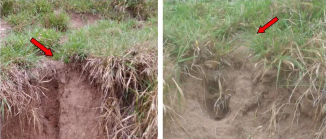
The areas had greater fragility to the displacement action of the surface water. The places marked as channels or drains are larger where the water volume was
Página | 227
displaced into the gully, reaching more intensively the walls and causing greater disintegration of the particles (Figure 2).
The channels determine the potential orientation of the development of the gully with a strong tendency to widening and expansion due to the concentration of drain in the mitigating actions. It must pass through systems that avoid the arrival of the water to the gully walls with so much volume and intensity.
The surface model (raster) allowed representation of the gully an in three-dimensional image (Figure 3) and the volumetric calculations of soil eroded with the surface tool in GIS software that enabled the quantification of soil removed and its increase after each evaluation.
Figure 2 – Photographs of the gully channels; a) Channel in the headwater areas; b) Channel on the left side
Source: Author (2016)
Figure 3. Gully three-dimensional model
25/11/2015 28/04/2016
Página | 228
The information about the volume of soil removed and the amount of rain between the surveys is shown in table 3.
The volume of eroded soil or empty space within the gully increased from 1585.33 m3 at the beginning of the monitoring to 1412.37 m3 at the end of the
evaluation, representing an 11% reduction in the volume of unoccupied spaces, suggesting the occurrence of sediment accumulation in the interior of the gully.
Table 3 – Volume values of eroded soil in the gully (m3) Survey Eroded volume
(m3)
Number of days between surveys
Rain in the period (mm) L1 1585.33 -- - L2 1508.01 38 271 L3 1370.79 66 571 L4 1301.24 26 235 L5 1412.37 37 394 Source: Author (2016)
The deposition occurred throughout the evaluation period with strong contribution of the exterior soils in the process. Leading to the believe that much of the deposited material originates on the hills and not only from the deposition of sediments from the walls. The presence of sandy soils under conditions of high rainfall under convex reliefs and poor vegetation cover results in high susceptibility to water leaching in the process known as laminar erosion.
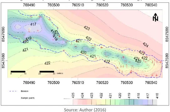
The isograms represent altimetry provided explanatory elements of the expansion process by noting that the phenomenon of soil loss occurs mainly at the edges of the headwaters and on the nearby sides. There is also an accumulation of solid material inside (Figure 4 and 5).
The gully advance decreases the productive areas with soil losses in the walls and the edges due to the initial detachment in the superficial layers followed by the removal of the rest of the material and sediment accumulation that occurs mainly in the lower third.
Retaining sediments in the interior can be attributed to several factors such as the existence of small wells in the bottom associated with small internal gradients (micromorphology at the bottom) that in some points produces greater energy of water flowing, generating different depths in the incision that occurs gradually in the soil. The internal structure in the irregular "V" format with an absence of channel flow makes it difficult to remove and transport the deposited material. The presence of forest formation after the final third prevents the total withdrawal of the sediment from within the channel.
The evolution of the gully is consisting with the one observed by Augustin and Aranha (2006) who states that soil loss indicates that the water runoff begins the removal and transport of material, before reaching the edges of the gullies, carrying material from outside to inside. After reaching the edges, the erosive power of the flow increased by the thicker material in transport, removing the soil in the walls and headwaters.
Página | 229
Figure 4. Gully isolation maps at the beginning of the monitoring period
Source: Author (2016)
Figure 5. Gully isolation maps at the end of the monitoring period
Source: Author (2016)
In a similar meaning, Rocha (2007) states that the appearance of gullies is linked to the formation of concentrated surface flow by promoting drags on the gully surface. The action of groundwater provokes the intensification of the erosive process and favors the development of mechanisms such as internal erosion by prominence and transport particles.
Página | 230
CONCLUSION
Geodetic GPS monitoring was efficient in measuring soil loss with millimeter accuracy – appropriate to identify small soil loss advances - with the necessary speed in frequent monitoring, as well to ease the information processing and analysis.
The products obtained by the ordinary kriging allowed the identification of the evolution dynamics of the gully bringing behavior details, such as places of greater impacts by the action of the superficial water, soil behavior in the interior and the geometric evolution of the edge.
The monitoring method adopted proved to be close to reality because it considered the irregularities at the bottom of the erosive incision for the calculation of soil loss, making this a viable alternative to the erosion monitoring in comparison to the traditional method.
The erosive aspect is directly related to the superficial and subsurface water flow disconnected from the drainage flow (headwater) downstream in the longitudinal direction of the gully channel with longitudinal ‘V’ shapes without lateral branches.
The upstream region of the gully was more susceptible to the detachment and particle transport. It dumps a large amount of sediments downstream capable of silting internal areas of the erosion itself and/or external areas such as the channel itself or its surroundings.
Página | 231
GPS geodésico aplicado no entendimento
da evolução de voçorocamento em áreas de
pastagens cultivadas no município de
Colorado do Oeste – RO
RESUMO
A erosão é um fenômeno que acompanha o desenvolvimento e a evolução da sociedade humana, e o emprego de novas tecnologias para monitoramentos de processos erosionais têm evoluído ao longo dos anos. Dessa forma, buscou-se ampliar as discussões sobre novas técnicas de monitoramento e mensuração de processos erosivos em escala temporal reduzida por meio de receptores geodésicos do Sistema Global de Navegação por Satélite (GNSS). Foram realizados 05 (cinco) levantamentos com o modelo TOPCON, nos métodos de posicionamento: Real Time Kinematic - RTK e Estático Rápido, durante 06 meses (novembro de 2015 a maio de 2016) correspondente a maior intensidade pluviométrica. Após o pós-processamento dos pontos, eles foram submetidos à análise geoestatística (krigagem ordinária). Assim, identificou-se que a técnica empregada é efetiva na mensuração do solo erodido. Os resultados obtidos a partir da interpolação identificaram detalhes da dinâmica erosiva, como: os locais onde as águas superficiais atingem as paredes com mais intensidade, a remoção de sedimento das vertentes e a consequente deposição no interior da incisão e a fragilidade na cabeceira do voçorocamento. Logo, o emprego de receptores geodésicos de GNSS apresenta-se como um método adequado no estudo dos processos erosionais e, também, uma alternativa aos métodos tradicionais de levantamento devido à precisão e à rapidez nas mensurações.
Página | 232
REFERENCES
ALMEIDA, H. R. R. C. Séries Temporais de Imagens Sub-Orbitais e Orbitais de Alta Resolução Espacial na Avaliação da Morfodinâmica Praial no Município do Cabo de Santo Agostinho –PE. 2009. 106f. Dissertação (Mestrado em Ciências Geodésicas e Tecnologias da Geoinformação). Universidade Federal de Pernambuco, Recife, 2009
AMARO, V. E.; GOMES, L. R. S.; LIMA, F. G. F. DE; SCUDELARI, A. C.; NEVES, C. F.; BUSMAN, D. V.; SANTOS, A. L. S. Multitemporal Analysis of Coastal Erosion Based on Multisource Satellite Images, Ponta Negra Beach, Natal City, Northeastern Brazil. Marine Geodesy, v. 38, n. 1, p.1-25, 2014.
https://doi.org/10.1080/01490419.2014.904257
ANA. Agência Nacional de Água. Séries Históricas de Estações. Disponível em: < http://www.snirh.gov.br/hidroweb/serieshistoricas>. Acesso em: 02 de abril de 2018.
AUGUSTIN, C. H. R. R.; ARANHA, P. R. A. A ocorrência de voçorocas em Gouveia, MG: características e processos associados. GEONOMOS, v.14, n. 2, p.75-86, 2006.
https://doi.org/10.18285/geonomos.v14i2.112
FONSECA, E. L. Avaliação do nível de degradação das pastagens cultivadas com
Brachiaria brizantha cv. marandú na região de Ji-Paraná/RO. 2009. Trabalho de
Conclusão de Curso. Centro Universitário Luterano de Ji-Paraná. Ji-Paraná – RO, 2009.
FONSECA, E. L. Processos erosivos em superfícies tabulares com evolução de voçorocamento em áreas de pastagens cultivadas (Braquiaria brizantha cv. marandu) no município de Colorado do Oeste – Rondônia. 2017. 161f. Dissertação (Mestrado em Geografia) – Fundação Universidade Federal de Rondônia – UNIR. Porto Velho, 2017.
FONSECA, E. L.; LOCATELLI, M.; SILVA FILHO, E. P. NDVI aplicado na detecção de degradação de pastagens cultivadas. Confins [Online], 35, 2018.
https://doi.org/10.4000/confins.13180
FRANCISCO, A. B. Estimativa de Taxas de Erosão Linear através de Levantamento por posicionamento Global e Densidade do Solo. Revista Brasileira de Geografia
Física, v.5, p.1035-1045, 2012. https://doi.org/10.26848/rbgf.v5.5.p1035-1045 FREITAS, I. C., et al. Resistência à penetração em Neossolo Quartzarênico submetido a diferentes formas de manejo. Revista Brasileira de Engenharia
Agrícola e Ambiental, v. 16, n. 12, p.1275-1281, 2012.
Página | 233
GHOSH, M. K. et al. Monitoring the coastline change of Hatiya Island in Bangladesh using remote sensing techniques. ISPRS Journal of Photogrammetry and Remote
Sensing, v. 101, p. 137-144, 2015.
https://doi.org/10.1016/j.isprsjprs.2014.12.009
GUERRA, A. J. T. Processos erosivos nas encostas. In: GUERRA, A. J. T. e CUNHA, S. B. Geomorfologia - uma atualização de bases e conceitos. Rio de Janeiro: Bertrand Brasil, 8ª ed., 2009. p.149-209.
GUERRA, A. J. T.; CUNHA, S. B. Degradação ambiental. In: CUNHA, S. B.; GUERRA, A.J.T. Geomorfologia e meio ambiente. São Paulo: Bertrand Brasil, 1996. p.337-376.
GUERRA, A. T.; DA SILVA, A. S.; BOTELHO, R. G. M. Erosão e conservação dos solos:
conceitos, temas e aplicações, 9 ed. Rio de Janeiro: Bertrand Brasil, 2014. 340p.
IBGE. Instituto Brasileiro de Geografia e Estatística. Censos demográficos 2010. Disponível em: <http://www.ibge.gov.br/>. Acesso em: 23 de setembro de 2016. INCRA - Instituto Nacional de Colonização e Reforma Agrária. Manual Técnico de
Posicionamento, 1 ed. Brasília: MDA, 2013, 37p.
LEAL, P. C. B. et al. Monitoramento Erosivo Através de Estaqueamento. Fazenda Experimental do Glória. Anais... In: Simpósio Nacional De Geomorfologia (SINAGEO) e Encontro Latino-Americano De Geomorfologia, VII e II, 08/2008, Belo Horizonte. Anais... VII SINAGEO e II Encontro Latino-americano de Geomorfologia, Belo Horizonte: UFMG, 2008.
LEAL, P. C. B.; RODRIGUES, S. C. Uso e comparação do método de estaqueamento, o método DGPS e geoprocessamento no monitoramento de uma área erosiva na fazenda do Glória – Uberlândia, MG. GEOUSP - Espaço e Tempo, nº 29, p.18 - 35, 2011. https://doi.org/10.11606/issn.2179-0892.geousp.2011.74184
LOPES, S. L.; GUERRA, A. J. T. Monitoramento de voçorocas por satélites GPS em áreas de areia quartzosa podzolizada: Praia Mole, Florianópolis – SC. Anais... VII Simpósio Nacional de Controle de Erosão Goiânia-GO, v. 1, n. 1, 2001, p. 106. MACEDO, J. R. et al. Uso e Conservação de Solos Arenosos sob Pastagens em São
Gabriel do Oeste, MS: recomendações técnicas (Circular técnica n° 3). Rio de
Janeiro: EMBRAPA-CNPS, 1998
MADRUGA FILHO, J. D. Aspectos Geoambientais entre as praias do Paiva e Gaibu,
Município do Cabo de Santo Agostinho (Litoral Sul de Pernambuco). 2004. 272p.
Tese (Doutorado, Curso de Pós-Graduação em Geociências). Universidade Federal de Pernambuco, Recife, 2004.
Página | 234
MAGALHÃES, R. A. Erosão: definições, tipos e formas de controle - Companhia Energética de Minas Gerais – CEMIG. VII Simpósio Nacional de Controle de Erosão Goiânia -GO. Anais[...], v.3, 03 a 06 de maio de 2001.
MORAES, M. V. A. Monitoramento e avaliação de processos erosivos marginais em reservatórios de usinas hidrelétricas por meio de varredura a laser. 2016. 96f. Dissertação (mestrado) - Universidade Estadual Paulista, Faculdade de Ciências e Tecnologia - Presidente Prudente, 2016.
MOREIRA, J. A. A.; OLIVEIRA, I. P.; GUIMARÃES, C. M.; STONE L. F. Atributos químicos e físicos de um Latossolo vermelho distrófico sob pastagens recuperada e degradada. Pesquisa Agropecuária Tropical, v. 35, n. 3, p.155-161, 2005. MORINAGA, M. S. Análise morfotectônica e morfoestrutural no controle de
erosões hídricas lineares na região de Marília (SP). 2014. 141f. Dissertação
(Mestrado em Geociências e Ciências Exatas). Universidade Estadual Paulista Júlio de Mesquita Filho. Rio Claro, 2014.
PESSOA-DE-SOUZA, M. A.; ALMEIDA, R. T. S.; DAS NEVES, C. M. N.; de CASTRO, J. P. V.; DE CASTRO, S. S. Comportamento químico de Neossolos Quartzarênicos em Mineiros, sudoeste goiano. Geociências, v. 34, n. 3, p.335-347, 2015.
PLANAFLORO, Diagnóstico Sócio Econômico – Ecológico do estado de Rondônia,
Zoneamento Sócio–Econômico- Ecológico de Rondônia – ZSEE-RO, volumes 1 a
16. Governo de Estado De Rondônia, Porto Velho, 1998 Disponível em: < http://cogeo.sedam.ro.gov.br/acervo-tecnico/ >. Acesso 21 de set. 2020.
QUADROS, M. L. E. S.; RIZZOTTO, G. J. Geologia e Recursos minerais do Estado de Rondônia: Sistema de Informações Geográficas–SIG: Texto explicativo do mapa geológico e de Recursos Minerais do Estado de Rondônia: relatório técnico. Rondônia, 2007.
ROCHA, E. A. V. Avaliação do processo evolutivo e da dinâmica erosiva: um
estudo de caso no município de Ipameri-GO. 2007, 114f. Dissertação (Mestrado
em Geografia). Universidade Federal de Uberlândia. Uberlândia, 2007.
SANTANA, N. M. P.; CASTRO, S. S.; STONE, L. F.; SILVA, S. C. Chuvas, erosividade, erodibilidade, uso do solo e suas relações com focos erosivos lineares na alta bacia do Rio Araguaia. Sociedade & Natureza, v. 19, n. 2, p.103-121, dez. 2007.
SCHERER, V.S. et al. Pressão de preconsolidação e índice de compressão de Neossolos Quartzarênicos em áreas sob voçorocamento. XXVII Congresso Nacional de Estudantes de Engenharia Agrícola e Engenharia Agrícola e Ambiental.
Página | 235
SEDAM. Secretaria de Estado do Desenvolvimento Ambiental. Boletim
Climatológico de Rondônia - ano 2008. Porto Velho, 2010, 36 p.
SILVA, A. M. Rainfall erosivity map for Brazil. Catena, v. 57, n. 3, p.251-259, 2004.
https://doi.org/10.1016/j.catena.2003.11.006
SILVA, A.; SOUZA FILHO, E. E.; NEVES, S.M.A.S. Erosão marginal e sedimentação no rio Paraguai no município de Cáceres (MT). Revista Brasileira de Geociências, v. 41, n.1, p.76-84, 2011. https://doi.org/10.25249/0375-7536.20114117684
SIQUEIRA. A. G.; AZEVEDO, A. A.; SOUZA, L. A. P. SILVA, M. Modificações Fluviais à Jusante de Barragens. In 14º Congresso Brasileiro de Geologia de Engenharia e Ambiental, 2013. Rio de Janeiro, RJ, Brasil. 14º Congresso Brasileiro de Geologia de Engenharia e Ambiental. Anais[...], 2013.
VALE JÚNIOR, J. F. et al. Erodibilidade e suscetibilidade à erosão dos solos de cerrado com plantio de Acacia mangium em Roraima. Revista Agroambiente. Boa Vista, v. 3, p. 1- 8, 2009. http://dx.doi.org/10.18227/1982-8470ragro.v3i1.253 VOLK, L. B. S. Condições físicas da camada superficial do solo resultantes do seu manejo e indicadores de qualidade para redução da erosão hídrica e do escoamento superficial. 2006. 149f. Tese (Doutorado em Ciência do Solo), Universidade Federal do Rio Grande do Sul, Porto Alegre, 2006.
Recebido: 09 jul. 2019
Aprovado: 10 set. 2020
DOI: 10.3895/rbgeo.v8n3.10338
Como citar: FONSECA, E. L.; SILVA Filho, E. P.; NOGUEIRA, W. K.S. Geodetic GPS applied to comprehend gully evolution in cultivated pasture areas in Colorado do Oeste – RO. R. bras. Geom., Curitiba, v. 8, n. 3, p. 222-235, jul/set. 2020. Disponível em: <https://periodicos.utfpr.edu.br/rbgeo>. Acesso em: XXX.
Correspondência:
Elaine Lima da Fonseca
Rua Antonio Carlos Zancan, 1334, CEP 76997-000, Cerejeiras, Rondônio, Brasil.
Direito autoral: Este artigo está licenciado sob os termos da Licença Creative Commons-Atribuição 4.0 Internacional.