Bol. Mus. Para. Emílio Goeldi. Cienc. Hum., Belém, v. 8, n. 1, p. 11-38, jan.-abr. 2013
11
Amazonian Dark Earths: pathways to
sustainable development in tropical rainforests?
Terra Preta Arqueológica: caminhos para o
desenvolvimento sustentável nas florestas tropicais?
Morgan Schmidt
Museu Paraense Emílio Goeldi/MCTI. Belém, Pará, Brasil
Abstract: Fertile dark anthrosols associated with pre-Columbian settlement across the Amazon Basin have sparked wide interest for their potential contribution to sustainable use and management of tropical soils and ecosystems. In the Upper Xingu region of the southern Amazon, research on archaeological settlements and among contemporary descendant populations provides critical new data on the formation and use of anthrosols. These findings provide a basis for describing the variability of soil modifications that result from diverse human activities and a general model for the formation of Amazonian anthrosols. They underscore the potential for indigenous systems of knowledge and resource management to inform efforts for conservation and sustainable development of Amazonian ecosystems.
Keywords: Anthrosols. Terra Preta. Historical ecology. Ethnoarchaeology. Upper Xingu.
Resumo: Antrossolos escuros e férteis associados a assentamentos pré-colombianos em toda a bacia amazônica têm despertado interesse por sua contribuição potencial no uso e manejo sustentável de solos e ecossistemas tropicais. Na região do alto rio Xingu, no sul da Amazônia, pesquisas sobre assentamentos arqueológicos e populações indígenas contemporâneas oferecem novos dados relevantes sobre a formação e o uso dos antrossolos. Os resultados fornecem uma base para a descrição da variabilidade de modificações no solo oriundas de diversas atividades humanas e um modelo geral para a formação de antrossolos amazônicos. A pesquisa mostra o potencial dos sistemas indígenas de conhecimento e manejo de recursos em contribuir na conservação e no desenvolvimento sustentável de ecossistemas amazônicos. Palavras-chave: Antrossolos. Terra Preta. Ecologia histórica. Etnoarqueologia. Alto Xingu.
SCHMIDT, Morgan J. Amazonian Dark Earths: pathways to sustainable development in tropical rainforests? Boletim do Museu Paraense Emílio Goeldi. Ciências Humanas, v. 8, n. 1, p. 11-38, jan.-abr. 2013.
Autor para correspondência: Morgan J. Schmidt. Museu Paraense Emílio Goeldi/MCTI. Coordenação de Ciências Humanas. Av. Perimetral, 1901. Terra Firme. Belém, PA, Brasil. CEP 66077-530 (morgan.j.schmidt@gmail.com).
InTRoDuCTIon
Amazonian dark earth (ADE) or terra preta (black earth) is a critical research topic for contemporary archaeology and historical ecology of Amazonia and potential strategies for sustainable development in tropical regions (Balée, 2010; Mann, 2002; Lehmann et al., 2003a; Glaser and Woods, 2004; Woods et al., 2009). Patches of human-modified, fertile ADE soil associated with pre-Columbian settlements provide vital clues as to the nature of prehistoric agriculture, landuse, and resource management that apparently sustained dense populations in some regions without significantly degrading environments or causing extinctions but rather enriching environments by concentrating fruit trees or creating patches of ADE (Balée, 1994; Graham, 2006). Amazonian dark earth also provides inspiration or a model for a developing controversial technology called biochar that is claimed will improve soil for agriculture and mitigate human-induced climate change by sequestering carbon in the soil (Ernsting and Smolker, 2009; Lehmann, 2007; Marris, 2006). The study of ADE can offer insights into sustainable environment and soil management in tropical regions mainly by revealing how ancient and modern indigenous Amazonians managed/manage their resources.
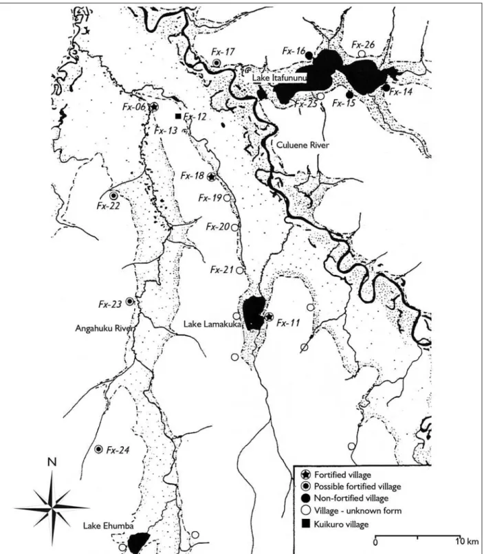
In most cases, the actual mechanisms of ADE formation are poorly understood due to limited archaeological research and a lack of contemporary ethnographic analogs for prehistoric agriculture and settlement patterns (Kern et al., 2009). Research in the Upper Xingu region of southeastern Amazonia (Mato Grosso state, Brazil), however, provides one of the clearest examples of large, densely settled pre-Columbian populations and intensive resource management in complex built environments with ethnographic analogs from descendant populations (Heckenberger, 1996, 1998, 2001, 2002, 2005; Heckenberger et al., 1999, 2003, 2007, 2008) (Figures 1-4). Results are presented here
from analyses of ADE soil associated with these large archaeological settlements and on soils in contemporary indigenous villages (Schmidt, 2010a, 2010b; Schmidt and Heckenberger, 2009a, 2009b). This study shows that ADE is forming under current activities and management practices in the Upper Xingu and that results from current and historically abandoned villages correlate to findings from nearby large archaeological settlements1.
There is continuing debate over the nature and extent of prehistoric human occupation in Amazonia (Barlow et al., 2012; Heckenberger et al., 1999, 2001; Lombardo et al., 2012; McMichael et al., 2012; Meggers, 2001, 2003; Roosevelt, 1991). Traditional views held that Amazonia was populated by small, mobile, and egalitarian horticultural tribes with relatively little impact on the environment and that, even on the várzea floodplains where populations were higher and social complexity greater, the environment (unpredictable floods in the
várzea and infertile soils and sparse game in the terra firme) set a ceiling on village size and social complexity (Meggers, 1954, 1996; Steward, 1946-1950). Those views have undergone substantial revision as archaeology has documented large, settled populations in several parts of the Amazon, as suggested by 16th to 17th century accounts
of dense populations in many areas (Heckenberger and Neves, 2009; McEwan et al., 2001; Moraes and Neves, 2012; Porro, 1994; Roosevelt, 1991; Viveiros de Castro, 1996). This indicates that much of the Amazonian tropical forest was substantially modified by pre-Columbian societies and post-1492 historical changes (Balée, 1994; Balée and Erickson, 2006; Heckenberger et al., 2003; Schaan et al., 2008). Although some researchers have cautioned that the anthropogenic impact must not be overestimated (Barlow et al., 2012; Bush and Silman, 2007; McMichael et al., 2012), large areas of Amazonia are virtually unknown archaeologically and ongoing
Bol. Mus. Para. Emílio Goeldi. Cienc. Hum., Belém, v. 8, n. 1, p. 11-38, jan.-abr. 2013
13
Bol. Mus. Para. Emílio Goeldi. Cienc. Hum., Belém, v. 8, n. 1, p. 11-38, jan.-abr. 2013
15 research is uncovering substantial ancient settlements with deep deposits of ADE in areas more distant from major rivers (Guapindaia, 2008; Lima et al., 2011; Pereira
et al., 2008). It remains to be seen whether there were large areas of Amazonia that were uninhabited (or lightly inhabited) by humans.
Integral to this debate are the patches of extremely fertile ADE soils noted by natural scientists since the 19th
century (Smith, 1879; Smith, 1980; Sombroek, 1966; Woods, 2003). Archaeological research has found an increase in the number and size of settlements with
terra preta beginning around the second half of the 1st
millennium B.C. and believed to be associated with increased population and agricultural intensification (Moraes and Neves, 2012; Neves and Petersen, 2006; Neves et al., 2003, 2004; Petersen et al., 2001). Patches of ADE contrast dramatically with the highly-weathered, acidic, and
nutrient-poor oxisols (Latossolos) and ultisols (Argissolos) that dominate the region and have limited agricultural use without high inputs of fertilizer or long fallow periods (Lehmann et al., 2003b; Glaser and Woods, 2004; Woods
et al., 2009; Smith, 1980; Sanchez and Buol, 1975). Amazonian farmers seek out ADE to grow crops because the extraordinarily high fertility allows them to grow a more diverse range of cultivars much more intensively than on the typical upland soils (Arroyo-Kalin, 2008; Fraser, 2010; Fraser et al., 2011a, 2012; German, 2001; Hiraoka et al., 2003; Kawa et al., 2011; Lehmann et al., 2003b; Smith, 1980; Steiner et al., 2009; Woods and McCann, 1999).
The long-term resilience of these soils is explained by the large amount of charcoal and rich diversity of organisms in them (Glaser et al., 2000; Ruivo et al., 2009; Thies and Suzuki, 2003; Tsai et al., 2009; Woods and McCann, 1999). Two broad categories define distinctive ADE, including darker terra preta soils with abundant archaeological ceramics, primarily associated with refuse disposal, and lighter terra mulata with few artifacts, located on the periphery of ancient settlements and likely associated with agricultural practices that introduced ash, charcoal, and organic material into the soils (Sombroek, 1966; Woods and McCann, 1999). These two varieties, which differ not only in color but also in soil chemistry, intergrade in areas of archaeological sites and are a rough guide to general formation processes related to habitation and cultivation areas (Fraser et al., 2011b). It is still difficult to evaluate the discrete behaviors that produced ADE, including whether some are intentional products or by-products of waste disposal or, likely, both (Sombroek, 1966). One way to address these questions is to carry out ethnoarchaeological research among contemporary indigenous groups to directly determine what impact their activities and cultivation practices have on the soil (Kern et al., 2009).
Before the present research (Schmidt, 2010a, 2010b; Schmidt and Heckenberger, 2009a, 2009b), a small number of studies had been published that were specifically focused Figure 3. Landsat TM image of the study area with overlying
on indigenous Amazonians’ soil management practices. Hecht and Posey (1989) and Hecht (2003) provided observations on soil management practices by the Kayapó, a group that inhabits the middle Xingu River Basin. Relatively intensive agricultural methods such as mulching, in-field burning, soil amendments, and/or repeated cycles of short-fallow slash and burn have been proposed as the origin of brown anthrosols in peripheral areas of settlements (terra mulata). Hecht (2003) suggests that these soil management practices as used among the Kayapó may be similar to practices that, in the past, produced ADE (Hecht and Posey, 1989). Their soil analyses showed significant enrichment in samples collected from areas of Kayapó soil management. Silva and Rebellato (2004) and Silva (2009) discussed
patterns of refuse disposal and the formation of anthrosols among the indigenous Asurini group of the middle Xingu River region, however, forthcoming soil analyses would be valuable for comparison with other data.
Bol. Mus. Para. Emílio Goeldi. Cienc. Hum., Belém, v. 8, n. 1, p. 11-38, jan.-abr. 2013
17 circular central plazas), and overall use of the landscape (elaborate systems of roads, bridges, fields, and aquatic resource management) throughout a chronological sequence spanning over a millennium (Heckenberger, 2005). This presents a unique opportunity to address questions about the range of activities that produced the soil variation found in archaeological sites.
Pedoarchaeological research documents predictable changes in soil properties, including elemental concentrations, caused by human activities, even those occurring over a relatively short time (Barba and Ortiz, 1992; Beck, 2007; Cook and Heizer, 1965; Kern and Kämpf, 1989; Knudson et al., 2004; Middleton and Price, 1996). In particular, nutrients that are abundant in living organisms, i.e., Ca, Cu, K, Mg, Mn, N, P, Sr, and Zn, are enriched in soils and sediments from the remains of organic materials (Bowen, 1966). In the present case, analyses document that distinct patterns of elemental enrichment occur from specific domestic, public, and subsistence activities in the southeastern Amazon (Heckenberger, 1996; Heckenberger et al., 1999; Schmidt, 2010a, 2010b; Schmidt and Heckenberger, 2009a, 2009b).
METHoDs
Soil samples were collected from a variety of contexts in current, historic, and prehistoric settlements and from off-site forest and agricultural contexts to determine how specific activities have impacted the soil in the study area. Occupational contexts that were sampled include the current village, two historic villages abandoned in the past 100 years, and three large prehistoric sites occupied by A.D. 850. Off-site contexts included forest, fields, and secondary forest or grass and scrub fallow. Areas that were sampled in the current village context included the plaza, house floors, backyards, fire hearths, manioc processing areas, and trash middens. Domestic areas, public areas, and trash middens were sampled in historic and prehistoric contexts.
Soil samples were collected using several different methods depending on the location. The majority of samples were collected using an 8 cm bucket auger to
extract a core up to 2 m deep. These include all of the samples from the forest, fallow, and the current and historic villages. Samples were collected in some contexts using a 3 cm soil probe or shovel. A sampling strategy was adopted that employed transects with samples taken at one meter intervals in an attempt to capture small-scale variability. The data from transects can be used to characterize a soil in a given area as well as show transitions between areas with different soil properties and chemical concentrations.
Each sample location had a minimum of two samples at 0-5 cm and 5-10 cm depths. Deeper samples were taken at 10 cm depth intervals. Middens were always sampled to greater depths (minimum 60 cm) due to their height, mounded up to approximately 40 cm above the former soil surface, producing 30 to 40 cm of dark topsoil. Further samples were collected at 50 cm intervals from activity areas with restricted size such as manioc processing areas that are a few meters across. In prehistoric sites, samples were collected from archaeological excavations using a trowel from the ground surface to the base of cultural sediments and from greater depths and areas outside excavations using a bucket auger or soil probe.
Samples were transported to the Museu Paraense Emílio Goeldi (MPEG) in Belém, Brazil, for processing and analysis. A portion of each sample was stored in a permanent collection in the Department of Archaeology at MPEG. Soil analyses included measurements of pH, organic carbon (OC), and the elements Al, Ba, Ca, Co, Cr, Cu, Fe, K, Mg, Mn, Na, Ni, P, Pb, Sr, Ti, V, and Zn. Samples were air-dried at room temperature and screened through 2 mm mesh. Soil pH was determined in water 1:2.5 with each sample stirred for two minutes, allowed to set for 20 minutes, and stirred briefly again before measurement. Organic carbon (OC) was determined by Walkley-Black modified.
procedure of hydrofluoric acid digestion was used (USA, 1996). The acids added were: 1.2 ml of HF 40% (v/v), 3.5 ml of HNO3 65% (v/v), 1 ml of HCl 37% (v/v) and 0.5 ml of H2O2 at 30% (m/m). The samples were removed from the microwave and 2 ml of solution of 100 g/l H3BO3 was added to fix the floridic acid in order to ameliorate its reaction with sensitive instrument components. A test was made for analytical recuperation using a standard reference material (SRM 2586) from the National Institute of Standards and Technology (NIST, USA). A Varian Vista Pro simultaneous Inductively Coupled Plasma Optical Emission Spectrometer2 (ICP OES) with axial viewing, a
radio frequency of 40 MHz, and charge-coupled device (CCD) detection were used to measure the metals.
The twenty soil variables were used in descriptive statistics and discriminant analyses to examine differences between groups of soil samples from different activity areas, how well groups can be separated, the classification hit-rate of samples, and which variables contribute most to group separation. Discriminant analyses presented here were carried out using the program XLSTAT version 2009.1.01 (updated January 2009). The data from Levels 1 and 2 (0-5 cm and 5-10 cm depth, respectively) were combined for the multivariate statistical analyses in order to obtain a larger sample size for each zone or activity area. Except in one case where the linear method was employed using PASW software, the quadratic method was used in the discriminant analyses presented here3.
REsulTs AnD DIsCussIon
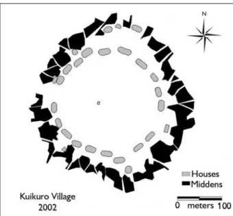
The composite results indicate that darker ADE is mainly formed in middens in backyard areas of dwellings, typically forming circular, rectilinear, or curvilinear mounds along backyard edges and trails (Figures 5 and 6). The degree of
mounding follows a regular pattern that is dictated by the placement of houses, backyard activity areas, and trails, thinning out gradually with distance from these areas. The highest mounds form at locations between houses or at intersections of trails with backyards or with other trails.
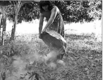
Observations in the current village documented the frequently changing locations of activities within the domestic and refuse disposal areas such as when backyard activity areas shift on top of middens, where fruit trees that were planted earlier now provide shade (Figure 7). In the current village, houses are sometimes built in areas further from the plaza edge in positions behind other houses, sometimes forming family compounds. In several observations, new houses were built over middens, with the midden being either scraped aside or leveled to create a level pad for the house. In one case fresh soil was dug up from the area surrounding the house and put in place to make a new house pad (3-5 cm thick) on top of the former midden. When domestic areas (houses and backyards) shift on top of middens in the current village, the area of active refuse disposal shifts too, thereby expanding the area of middens.
Low fertility indicators that are typical of Amazonian soils – high exchangeable Al, high acidity, and nutrient deficiencies – are absent in midden soil, offering ideal conditions for plant growth and crop cultivation. Midden soils contain a high pH and high OC content, and much lower Al and Fe contents than surrounding soils. Of all the areas tested, middens were found to have greatly elevated levels of the widest range of nutrients typically elevated by human activities (Ba, Ca, Cu, K, Mg, Mn, Na, P, Sr, and Zn) (Table 1).
Kuikuro farmers refer to patches of terra preta as ‘igepe’, meaning cornfield in their Carib language (Carneiro,
2 The designation ICP OES has been given to this technology by convention because of a naming conflict with the term ICP-AES, by which it is more commonly known. These analyses were carried out at Eletronorte, in Belém.
Bol. Mus. Para. Emílio Goeldi. Cienc. Hum., Belém, v. 8, n. 1, p. 11-38, jan.-abr. 2013
19 1983; Heckenberger, 2005). They travel up to 15 km to open gardens in the terra preta of archaeological sites where they plant diverse crops that typically don’t do well in normal soils (on normal soils they generally plant only manioc and sometimes piquí (Caryocar brasiliense) fruit trees). The crops planted in ADE include corn, bananas, sugarcane, sweet potatoes, cotton, and various fruit trees. Manioc is sometimes planted in these areas as well. Middens behind homes in the current village are used for cultivating the same diverse range of crops in home gardens and orchards on top of middens.
It is the fertile midden soil and the availability of abundant organic materials that act as fertilizer and mulch that makes the refuse disposal zone important cropland. Households typically plant nutrient demanding crops (annuals and perennials including fruit trees) in the trash middens behind their homes. Small patches of bitter and sweet manioc were also observed in some backyards on top of or adjacent to middens. Some old-world crops now
have an important place in the agricultural system including banana, sugarcane, and mango. The home gardens of three households were surveyed for useful crops planted in the middens in 2005. The three gardens contained 21, 15, and ten useful species that had been planted. Species included sweet potatoes, squash, corn, beans, sweet and bitter manioc, chili peppers, bottle gourd, calabash gourd (cuia), sugar cane, mango, papaya, piquí, cashew, banana, guava, orange, Antilles cherry (acerola), cotton, tobacco, and several native fruits from the region including species from the gallery forest and fallow or floodplain savannah.
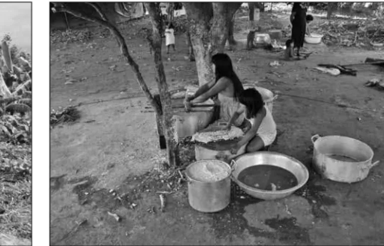
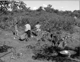
Sorting of refuse by type appears to be an important factor in the formation of darker, more nutrient rich soils nearer domestic areas (terra preta) and lighter, brown soils in more peripheral areas of settlements (terra mulata). Observations in the Kuikuro village suggest that materials such as hearth cleanings (ashes and charcoal), fish remains, and durable refuse such as broken ceramics are typically disposed of on the edges of the backyard while bulky organic waste, notably from manioc processing, is spread further away and over a wider area (Figures 8-11). Land on the periphery of the village is used for backyard homegardens or alternates between cultivated gardens, which are fertilized with organic refuse, mulched with weeds, and occasionally burned; and fallow areas used for defecation, refuse disposal, or processing plant materials (Figure 12). These activities result in darkened soil with elevated pH and OC and in nutrient enrichment similar to middens but at much lower magnitudes, thus analogous to
terra mulata (see results for fallow area in Table 1). Organic materials quickly break down in middens and midden material is mixed with the underlying soil. This is shown by increasing levels of Al, Fe, and V in the surface layers of middens as a result of bioturbation that moves underlying soil upwards, mixing it with midden material. Likewise, soil pH and some nutrients increase over time at greater depths underneath middens as midden material and nutrients are transported downward with bioturbation, leaching and other soil forming processes (Figure 13). Figure 5. Map of the Kuikuro village in 2002 drawn from GPS data.
Figure 7. Backyard activity area and manioc processing location under a shady fruit tree on top of a midden. Active refuse disposal has shifted further back and extends along trails. Source: Schmidt (2010b).
In addition to middens and cultivation areas, groups of samples from domestic and public areas show significant nutrient enrichment and distinctive soil signatures (Table 1). Fire hearth soil displayed an elevated pH, very low OC, and exceptionally elevated K content. Manioc processing areas showed substantial nutrient enrichment, high pH, and high OC. Soils in current village domestic areas were visibly darkened, have an elevated pH, an elevated OC content, and are significantly enriched with nutrients. The re-building of houses in the same general location, but usually shifted forward or backward, causes domestic areas to shift positions and overlap each other as the house footprint changes locations. The burning of houses, whether in controlled or accidental fires, adds large amounts of ash and charcoal to the soil. After fires, much of the debris are hauled away to the midden area and dumped while some gets thrown in the holes left when burnt posts are removed. Repeated house fires likely have a proportionally large effect on soil darkening and enrichment in domestic areas. The plaza center showed soil enrichment on par with domestic areas but with differences due to the digging
of graves, while the mid-range area of the plaza showed the least amount of enrichment in the village context.
Soil analyses from archaeological settlements, including recently abandoned Kuikuro villages (one occupied 1973-1983 and another ca. 1930-1940) and a large pre-Columbian settlement (Nokugu), showed that some properties of anthropically enriched soils significantly decrease over time in middens, including pH, OC, Ca, K, Mg, Na, Sr, P, and Zn (Table 1). Several soil variables were shown to be more stable in the soil over time – namely pH, Ba, Mn, and Sr – indicating that these are some of the most effective for detecting and documenting previous landuse and human impact on the soil4.
In order to acquire further information about the differences between groups of samples from different activity areas and attempt to determine in more detail their unique soil signatures, multivariate discriminant analyses were employed. The objectives of the analyses were to: a) clarify differences between activity areas by determining which of the soil properties can best be used to separate samples from different areas; and b) classify the samples Figure 6. Midden in the current village at the intersection of the
backyard with a trail where the highest mounds (~50 cm) are typically found. Source: Schmidt and Heckenberger (2009a).
Bol. Mus. P
ara. Emílio Goeldi. Cienc. Hum., Belém, v
. 8, n. 1, p. 11-38, jan.-abr
. 2013
21
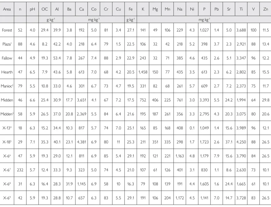
Table 1. Summary of group means for surface levels from the current and historic villages, offsite area (forest), and prehistoric sites. Notes: 1) midrange area of plaza (mid-plaza); 2) manioc processing area; 3) historic village; 4) prehistoric site Hialugihïtï, three transects in residential areas; 5) prehistoric site Akagahïtï, terra preta in central area; 6) prehistoric site Nokugu, terra preta samples from mounds and middens; 7) Nokugu domestic area; 8) Nokugu hearth feature; 9) Nokugu midden.
Area n pH OC Al Ba Ca Co Cr Cu Fe K Mg Mn Na Ni P Pb Sr Ti V Zn
g kg-1 mg kg-1 g kg-1 mg kg-1
Forest 52 4.0 29.4 39.9 3.8 192 5.0 81 3.4 27.1 141 49 106 229 4.3 1,027 1.4 5.0 3,688 100 11.5
Plaza1 88 4.6 8.2 42.2 4.0 218 6.4 79 1.5 22.5 106 32 42 218 5.2 398 3.7 2.3 2,921 88 13.4
Fallow 44 4.9 19.3 53.4 7.8 267 7.4 88 2.9 22.9 243 32 71 385 4.6 435 2.6 5.1 3,347 96 12.2
Hearth 47 6.5 7.9 43.6 5.8 613 7.0 68 4.2 20.5 1,458 150 77 435 3.5 613 2.3 6.2 2,802 85 15.5
Manioc2 79 5.5 10.8 33.0 4.6 301 6.7 73 4.7 19.5 331 82 68 261 5.7 609 2.7 7.2 2,373 75 11.7
Midden 46 6.6 25.4 30.9 17.7 3,651 4.1 67 7.2 17.5 752 406 225 761 3.0 3,393 5.5 24.2 1,994 64 29.8
Midden3 58 5.9 26.5 37.0 20.8 2,369 5.5 84 6.4 21.6 195 187 261 356 3.3 2,795 4.3 20.3 3,075 80 20.6
X-134 18 6.3 15.2 34.4 10.3 817 5.7 74 7.0 25.1 165 85 168 408 0.1 1,049 1.4 15.6 3,989 96 12.1
X-185 29 7.1 35.3 40.1 23.1 4,381 6.9 80 11 25.3 211 351 335 298 1.7 1,723 2.6 37.1 4,250 88 26.5
X-66 47 5.9 19.3 29.0 12.1 811 6.9 85 5.4 29.1 192 121 221 1,163 4.8 1,179 7.9 15.6 3,790 84 26.5
X-67 232 5.7 12.4 33.3 9.3 323 5.0 74 4.5 21.0 107 61 126 401 3.1 830 1.1 8.6 2,630 73 10.1
X-68 31 6.3 16.4 28.3 31.9 1,145 6.9 58 10 16.3 79 108 139 191 4.4 1,605 1.6 24.4 1,665 61 10.1
Figure 8. Disposal of hearth ash and charcoal in a midden at the edge
of a backyard. Source: Schmidt (2010b). Figure 9. Bulky organic plant waste (leaves, manioc peelings, etc.) being carried away from the backyard to be dumped along the trail. Source: Schmidt (2010b).
Figure 10. The surface of a midden in the historic Kuikuro I village (occupied 1973-1983). In this mounded midden on the edge of the former backyard, large potsherds, a metal pot, and large fragments of charcoal are visible on the surface. Source: Schmidt (2010b). into their respective groups based on the soil variables to
determine how accurately groups can be classified and which configurations of variables perform best.
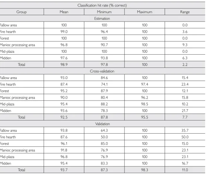
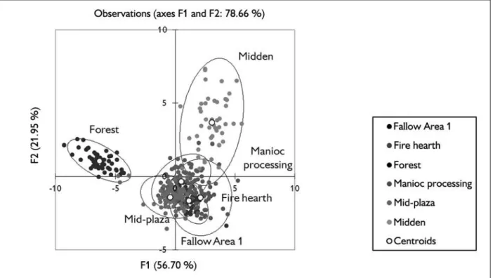
Discriminant analyses generally achieved better than a 90% classification hit rate for groups of samples from activity areas in the current village and prehistoric sites, showing significant differences in soil chemistry based on a suite of variables (Table 2). Territorial maps plot the discriminant Z scores for each observation on two functions (Figures 14 and 15). They graphically show the distance between centroids, the clustering or dispersion of observations for each group, and the separation or overlap of each group.
In an analysis using six groups from the current village and landscape, the territorial map (Figure 14) shows that: 1) forest samples are well separated from the other groups and fairly tightly clustered; 2) midden samples are more dispersed and partially overlap the other groups from the village; and 3) manioc processing and fire hearths in domestic areas, the mid range area of the plaza or mid-plaza, and the fallow area on the edge of the village all overlap one another. The close proximity of Fire hearths and Fallow Area 1 centroids and their distance from the midden centroid is noteworthy. Located in an area of cultivation and frequent burning
Bol. Mus. Para. Emílio Goeldi. Cienc. Hum., Belém, v. 8, n. 1, p. 11-38, jan.-abr. 2013
23 an intermediate position between the current midden and forest, reflecting the slow return of the midden soil toward forest soil conditions after abandonment, due to bioturbation, leaching, and other soil processes.
In a discriminant analysis using 12 variables, the results for the average of 100 repetitions and a 33% random validation (hold out) sample show numerically which groups have greater separation or overlap (Table 2). This analysis, using the variables pH, OC, Al, Ba, Ca, Co, Fe, K, P, Sr, Ti, and V, performed best out of twenty tests using different numbers and combinations of variables. The ordering of the groups from highest to lowest by the classification hit rates (% correct) of the validation sample are as follows: 1) mid-plaza (96.8%); 2) forest (96.1%); 3) midden (95.4%); 4) fallow area (93.8%); 5) manioc processing (91.8%); and 6) fire hearth (87.6%). The mid-plaza group, representing the base line soil conditions within the village context, scored the highest – meaning it had the least number of samples misclassified into other groups. Fire hearth and manioc processing areas, on the other hand, scored the lowest and had the most misclassified samples. They were more frequently misclassified with each other, partially due to their close proximity, i.e., ash spills from the hearth onto the manioc processing areas. The fact that
backyard areas sometimes lie on top of middens could also potentially lead to confusion between domestic samples and middens.
Figure 12. Agricultural work being done in a manioc garden at the edge of the village, adjacent to the fallow area where samples were collected. The soil here is visibly darkened. Source: Schmidt (2010b).
and nutrients, more similar to historic midden samples than typical mid-plaza samples.
Researchers employ a number of methods to judge the effectiveness or ‘power’ of variables in discriminating between groups, which can change depending on the analysis (Hair et al., 2006; Huberty and Olejnik, 2006). Perhaps one of the most reliable ways is the composite potency index whose results are presented here using two different discriminant analysis methods (Table 4). It is noteworthy that the variables pH and Ba consistently came out on top – two of the variables that also appear to be the most stable in the soil over time. A stretched vector plot shows graphically the effectiveness of the variables by another measure, the discriminant loadings (Figure 16). This graph shows the contributions of each variable to each of two functions (Function 1 contributes the most to group separation) as well as correlations between variables. In this case, it shows that the variables most increased by human impact (pH, OC, and soil nutrients) are highly correlated with one another, while those abundant in unmodified soil (Al, Fe, Ti, and V) are correlated with one another.
In summary, thirteen of the most significant conclusions pertinent to the formation of ADE that can
be drawn from current and historic village results are: 1) groups of soil samples from all of the activity areas displayed significant soil modifications; 2) midden soils stood out from the rest with the most highly elevated levels of the greatest range of soil properties (pH, OC, and nutrients); 3) the underlying soil is rapidly mixed with midden material, as shown by relatively high Al, Fe, and Ti in the upper levels of middens; 4) middens affect soil properties to a considerable depth, shown by elevated pH and nutrients at depths of at least 1-2 m below the midden; 5) middens form distinctive patterns on the landscape consisting of linear mounds along backyard edges and trails; 6) middens are used for cultivating diverse home garden crops; 7) activity areas shift frequently, such as when fruit trees planted in middens later provide shade for domestic activities, or when middens are leveled and houses are built on top of them; 8) pH, OC, and nutrients (Ca, Cu, K, Mg, Na, P, Sr, and Zn) were shown to decrease in middens over time; 9) several variables, including pH, Ba, Mn, and Sr, appear to be more stable over time and are therefore among the best for determining anthropic impacts on the soil; 10) refuse disposal, soil management, and cultivation practices in peripheral areas of the settlement formed darkened soils with elevated pH, OC, and nutrients, but much less elevated than middens, analogous to terra mulata; 11) public and domestic areas were significantly impacted and displayed marked differences in soil properties from both middens and forest soil; 12) some of the activity areas displayed distinctive soil signatures, such as fire hearths with greatly elevated pH and K and a low OC content (however, the K in hearths appears to decrease rapidly over time); and 13) certain elements, including Cu, Cr, Na, Ni, and Pb, were less useful in discriminant analyses because of their high variability.
Bol. Mus. Para. Emílio Goeldi. Cienc. Hum., Belém, v. 8, n. 1, p. 11-38, jan.-abr. 2013
25
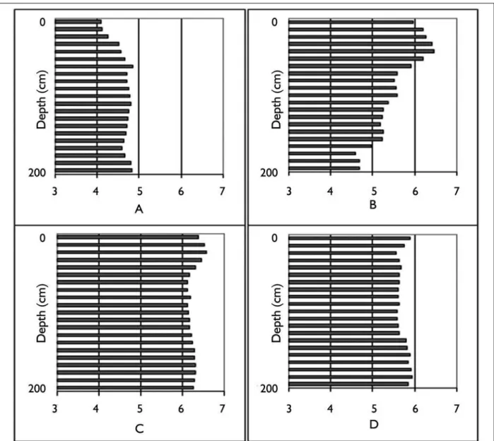
Figure 13. Soil pH by depth level in two-meter profiles in forest and three middens of different ages. A) Forest; B) Current midden; C) Historic midden; D) Prehistoric Nokugu midden.
agricultural works5 (Erickson, 2008; Heckenberger, 2005).
Distinctive mounds of ADE formed from construction and maintenance activities and from refuse disposal in middens in locations that were dictated by the use of domestic and public space, much as in the current Kuikuro village
(Figure 17). In prehistoric sites linear mounds define plazas and roads, dividing public space from residential areas (Figure 18). Prehistoric landscape and soil modifications included the excavation of massive ditches at the larger sites. The ditches, up to 5 m deep and over 1 km long,
Table 2. Results for a discriminant analysis using six groups from the current village and landscape. Results are of 100 repetitions using the quadratic method with 12 variables and a 33% random holdout sample (n = 356). Variables included in the analysis: pH, OC, Al, Ba, Ca, Co, Fe, K, P, Sr, Ti, V.
Classification hit rate (% correct)
Group Mean Minimum Maximum Range
Estimation
Fallow area 100 100 100 0.0
Fire hearth 99.0 96.4 100 3.6
Forest 100 100 100 0.0
Manioc processing area 96.8 90.7 100 9.3
Mid-plaza 100 100 100 0.0
Midden 97.6 93.8 100 6.3
Total 98.9 97.8 100 2.2
Cross-validation
Fallow area 93.0 84.6 100 15.4
Fire hearth 87.4 74.1 97.4 23.4
Forest 95.2 87.9 100 12.1
Manioc processing area 90.0 80.4 96.2 15.8
Mid-plaza 95.4 88.2 98.5 10.2
Midden 93.6 78.3 100 21.7
Total 92.5 87.8 95.5 7.7
Validation
Fallow area 93.8 64.3 100 35.7
Fire hearth 87.6 50.0 100 50.0
Forest 96.1 85.0 100 15.0
Manioc processing area 91.8 76.9 100 23.1
Mid-plaza 96.8 76.9 100 23.1
Midden 95.4 83.3 100 16.7
Total 93.7 87.3 98.3 11.0
were likely used as part of defensive works that probably included palisade walls.
The largest mounds are found around the plaza(s) and on the roads leading out of them. Mounds generally decrease in size with distance from the settlement but they could still be identified and mapped for several kilometers in between sites. Mounds surrounding the circular plazas were excavated and found to contain dark soil and abundant material remains (mostly broken ceramics) giving them the
Bol. Mus. Para. Emílio Goeldi. Cienc. Hum., Belém, v. 8, n. 1, p. 11-38, jan.-abr. 2013
27
Group Current midden Fallow area Forest middenHistoric Mid-plaza
from\to observation % correct
Current midden 44 0 0 2 0 95.7
Fallow area 3 40 0 1 0 90.9
Forest 1 0 48 3 0 92.3
Historic midden 2 0 0 56 0 96.6
Mid-plaza 0 0 0 2 86 97.7
Total 95.7
Table 3. Confusion matrix with cross-validation results for a five group analysis including historic midden samples (see Figure 15).
Table 4. Ranking of variables by the composite potency index for the analysis with six groups from the current village and landscape. These were calculated from the structure [r]’s using ELSTAT software (quadratic method) and rotated structure [r]’s using PASW software (linear method). In the third column is a combined ranking from the two methods.
ELSTAT Rotated (PASW) Combined rank
Rank Variable potency indexComposite Rank Variable potency indexComposite Rank Variable
1 pH 0.339 1 Al 0.098 4 Ba
2 Ba 0.252 2 Ba 0.073 6 pH
3 Fe 0.239 3 P 0.059 8 Ti
4 Ti 0.236 4 Ti 0.057 11 P
5 V 0.203 5 pH 0.055 11 V
6 OC 0.199 6 V 0.049 13 OC
7 Sr 0.184 7 OC 0.047 14 Fe
8 P 0.181 8 Ca 0.042 15 Al
9 Ca 0.176 9 Co 0.042 17 Ca
10 Mg 0.163 10 Sr 0.036 17 Sr
11 Zn 0.155 11 Fe 0.032 22 Co
12 Mn 0.125 12 Zn 0.029 23 Zn
13 Co 0.112 13 K 0.027 24 Mg
14 Al 0.110 14 Mg 0.026 27 Mn
15 K 0.099 15 Mn 0.025 28 K
16 Na 0.083 16 Pb 0.010 33 Pb
17 Pb 0.054 17 Ni 0.010 34 Na
18 Cu 0.052 18 Na 0.010 36 Ni
19 Ni 0.026 19 Cu 0.008 37 Cu
Bol. Mus. Para. Emílio Goeldi. Cienc. Hum., Belém, v. 8, n. 1, p. 11-38, jan.-abr. 2013
29
Figure 16. Stretched vector plot of discriminant loadings for Functions 1 and 2 in the analysis using six groups from the current village and landscape.
Present day roads in the Upper Xingu are still maintained by scraping weeds (pulled out by the roots) to the edges, forming linear mounds of soil and dead vegetation.
In residential areas, mounds are found on the surface often overlying stratified deposits of dark earth and other cultural material (mainly ceramics). Curvilinear mounded middens were located and sampled in residential areas surrounding the plaza. In these areas, low mounds surrounding flat circular areas, some with a lowering in the mounds on opposite sides corresponding to the locations of doorways, apparently mark the locations of houses. Three groups of soil samples
Figure 17. Southern profile of a midden at Nokugu (40 cm depth). The darkest soil and ceramics extend to about 30 cm depth on the eastern half and there is a possible pit feature in the western half that extends to about 40 cm depth. Source: Schmidt (2010b).
Figure 18. Map of the prehistoric site Nokugu (MT-FX-06) drawn from GPS data showing linear mounds (thin lines) and ditches (thick lines). Source: Heckenberger (2005).
Soil analyses from samples collected in transects and select locations at three prehistoric sites (Nokugu (MT-FX-6), Hialugihïtï (MT-FX-13), and Akagahïtï (MT-FX-18) reflect the patterns of mound formation (Figure 19). Mounded middens and plaza mounds showed the highest OC and pH and greatest nutrient enrichment, most similar to current and historic middens in the contemporary context (Tables 5 and 6). Some locations were notably more enriched with nutrients, for example, the mound around the small plaza at Nokugu (Table 6) and the central area of Akagahïtï, a site that showed especially marked soil enrichment (Table 1). Samples from transects through residential areas displayed highly variable pH, OC, and nutrient enrichment. The variation along transects, with samples taken every 10 or 20 m, suggests alternating locations of habitations and middens.
Prehistoric settlement patterns include networks of closely spaced (3-8 km) large walled towns (30-50 ha), smaller plaza villages (≤15 ha), and non-plaza ADE hamlets, integrated by well-maintained roads, and indicative of a much more fixed and compartmentalized settlement and agricultural landscape (Heckenberger et al., 2008). Manioc agriculture and wetland management provided the economic foundation of these prehistoric societies, but land-use would have likely been more intensive, including more fixed agricultural areas and shorter-cropping, because of the dense settlement (Heckenberger, 2005; Schmidt, 2010b). Amazon dark earth was likely used to support intensive agriculture with crops grown within and surrounding villages. These findings indicate that prehistoric farmers were creating and using ADE in and around settlements likely as an important component of their agricultural system used to increase production and improve sustainability. However, not all terra preta was used for cultivation, as indicated by the deep mounding in some locations, the large size of potsherds, and the apparently densely packed habitation structures at many Amazonian sites with large deposits of
terra preta (Schmidt, 2010b, 2012a, 2012b). deposits, probably formed when middens were leveled
Bol. Mus. Para. Emílio Goeldi. Cienc. Hum., Belém, v. 8, n. 1, p. 11-38, jan.-abr. 2013
31
Table 5. Nokugu midden profile results for pH, OC and seven nutrients.
Depth (cm) pH OC Ba Ca K Mg Mn P Sr
g kg-1 mg kg-1
0-5 6.1 38.6 18.7 1,460 244 339 258 1,524 23.7
5-10 6.1 21.0 13.1 402 157 71 238 1,275 13.7
10-20 6.0 18.7 17.4 1,027 254 114 455 1,416 19.8
20-30 5.9 22.6 17.9 674 215 44 432 1,469 19.6
30-40 6.0 11.3 14.9 753 189 48 299 1,041 15.3
40-50 6.0 9.4 9.6 586 153 40 237 815 15.3
50-60 5.9 8.6 7.8 615 159 54 215 692 15.4
60-70 5.9 4.3 6.1 496 74 42 168 630 14.7
70-80 5.9 3.5 5.8 440 160 33 145 598 16.1
80-90 5.9 3.5 5.1 471 140 38 142 533 13.3
90-100 6.0 3.1 6.7 479 214 48 142 504 17.0
100-110 5.9 1.6 4.4 430 145 58 135 485 13.7
110-120 5.9 3.1 5.5 430 141 55 142 409 9.8
Table 6. Nokugu small plaza mound profile results for pH, OC and seven nutrients.
Depth (cm) pH OC Ba Ca K Mg Mn P Sr
g kg-1 mg kg-1
10-20 5.9 23.8 43.4 6,716 289 873 686 3,153 48.9
20-30 6.0 19.2 43.2 1,746 208 154 585 1,738 25.4
30-40 6.0 18.0 48.3 1,713 200 177 635 1,758 25.8
40-50 6.0 21.5 52.6 1,654 222 219 731 1,905 27.0
50-60 6.0 12.2 30.9 872 204 118 404 1,373 18.5
60-70 6.0 13.0 31.2 1,183 217 140 432 1,268 23.2
70-80 5.8 9.9 22.1 896 165 115 315 1,191 19.0
80-90 5.9 6.0 10.8 608 151 52 182 819 15.1
ConClusIon
A new view of prehistoric Amazonia has emerged as a center for the development of agriculture and complex society with dense populations that significantly impacted their environment (Heckenberger and Neves, 2009; Roosevelt, 1999a, 1999b; Viveiros de Castro, 1996). This gives the region new importance for understanding the development of sociopolitical complexity, intensification of subsistence, and human-environment interaction. There is an intense interest in ADE for its promise to teach us
Bol. Mus. Para. Emílio Goeldi. Cienc. Hum., Belém, v. 8, n. 1, p. 11-38, jan.-abr. 2013
33 settled populations in the Amazon, notably intensive agriculture, arboriculture, and management of aquatic resources (Heckenberger, 2005; Balée and Erickson, 2006; Heckenberger and Neves, 2009).
This research is particularly relevant and timely in the Upper Xingu basin which lies in a unique transitional environment between the Amazon rainforest and the savanna (Cerrado) of central Brazil. It is in one of the regions of Amazonia hardest hit by deforestation and development – satellite images show Xingu Indigenous Park standing out as an island of forest and savanna surrounded by areas cleared for modern agriculture and pasture. The research adds new information about the prehistoric and current management of tropical environments and contributes to discussions on the extent of cultural versus ‘pristine’ forests in the tropics, particularly in the light of new data on the prehistoric human landscape (Heckenberger et al., 2003). The research yields information on fertility and management of tropical forest soils and may contribute to an understanding of the role of soils, particularly anthrosols, in acting as a sink for atmospheric carbon. Furthermore, the research promotes changing perspectives on tropical forest peoples and provides local Amerindians with information on their history and continuity in the region as well as training that gives them greater pride and power for protecting their archaeological sites, culture, environment, and territorial rights.
Concern over degraded agricultural land and how to feed a growing population have prompted efforts to develop new sustainable tropical production systems, sometimes modeled on traditional systems, such as agroforestry systems that incorporate soil management (National Research Council, 1993). Archaeology documents that large prehistoric populations in Amazonia enriched the soil on the land they lived and cultivated, resulting in substantial tracts of ADE. These fertile soils hold valuable lessons for resource management in the tropics (Lehmann
et al., 2003a; Glaser and Woods, 2004; Glaser, 2007; Woods et al., 2009). The high carbon content of ADE has
implications for the global carbon cycle and climate change (Sombroek et al., 2003). A controversial technology inspired by terra preta research called biochar is being promoted as a technique for simultaneously improving soil fertility and acting as a sink for atmospheric CO2 (Leach et al., 2012; Mann, 2002; Marris, 2006). The way that indigenous populations managed their environments in the past has molded the patterns of biodiversity that are observed today in Amazonia and therefore have profound implications for the biological sciences (Balée, 1994, 1998; Balée and Erickson, 2006; Hecht and Posey, 1989; Heckenberger et al., 2007). Thus, ADE inform agriculture, conservation, and development efforts in tropical regions as well as plans for sequestering carbon in order to lessen the impact from human-induced global warming. Amazonian dark earths are a prime example for historical ecology, fundamental to understanding the ecology and biogeography in the South American Tropics.
Beyond the anthropic soils of the Upper Xingu, this research is generally pertinent to pedoarchaeological studies everywhere because darkened soils are a common feature at many archaeological sites around the world. The ethnoarchaeological research in the Upper Xingu was found to be fundamental to understanding ADE formation in archaeological sites in other regions of the Amazon where recent research has been carried out including the Central Amazon and the lower Trombetas River region (Guapindaia, 2008; Neves et al., 2003; Schmidt, 2010a, 2012a, 2012b). Anthrosols that share similarities with terra preta have been recorded throughout the tropics in Central America, the Caribbean, Africa, Southeast Asia, and the Pacific (Leach
et al., 2012; Schmidt, 2010b; Sheil et al., 2012; Woods, 2003). The darkened soil can be formed in middens or by intensive agricultural activities. Shell middens from the U.S.A. to southern Brazil often show the characteristics of terra preta with the addition of shells. Darkened anthrosols or middens, some thousands of years old, are found throughout the American tropics in a great diversity of environmental and cultural contexts.
This research asks the question: ‘How was terra preta
formed?’. The objective was to develop soil analysis as a more useful tool in Amazonian archaeology by trying to understand the specific processes that formed terra preta. It is also hoped that the results will help those trying to understand the nature of terra preta and its high fertility in order to improve the fertility of soil in the tropics to help farmers increase their productivity and sustainability. The hope is that the ethnoarchaeological information about anthrosol formation will form a basis for further studies on
terra preta formation processes and properties and may be applied to help interpret pedoarchaeological data from sites across the Amazon region and beyond. Further research on the collection of samples at the Museu Paraense Emílio Goeldi will focus on additional soil analyses to confirm the results and to understand in greater detail how soils are transformed by human activities in the Upper Xingu.
ACKnowlEDGEMEnTs
Bol. Mus. Para. Emílio Goeldi. Cienc. Hum., Belém, v. 8, n. 1, p. 11-38, jan.-abr. 2013
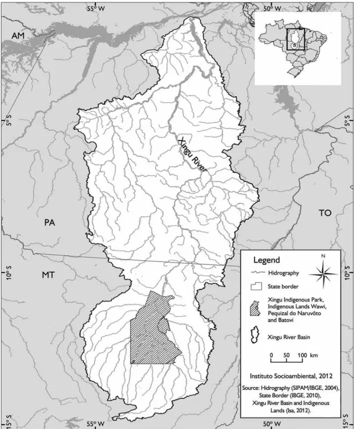
35 Robert and Sharon Schmidt. The Instituto Socioambiental (ISA) graciously provided the map of the Xingu Basin (Figure 1). I also thank two anonymous reviewers for their constructive comments.
REfEREnCEs
ARROYO-KALIN, M. steps towards and ecology of landscape: a geoarchaeological approach to the atudy of anthropogenic dark earths in the central Amazon region, Brazil. 2008. Thesis (Doctoral of Archaeology) – University of Cambridge, Cambridge, 2008. BALÉE, W. Amazonian Dark Earths. Tipití: Journal of the society for the Anthropology of lowland south America, v. 8, n. 1, p. 1-18, 2010.
BALÉE, W. (Ed.). Advances in historical ecology. New York: Columbia University Press, 1998.
BALÉE, W. footprints of the forest: Ka’apor Ethnobotony– the historical ecology of plant utilization by an amazonian People. New York: Columbia University Press, 1994.
BALÉE, W.; ERICKSON, C. (Eds.). Time and complexity in historical ecology: studies in the neotropical lowlands. New York: Columbia University Press, 2006. (The Historical Ecology Series). BARBA, L.; ORTIZ, A. Analisis quimico de pisos de ocupación: un caso etnografico en Tlaxcala, Mexico. latin American Antiquity, v. 3, n. 1, p. 63-82, 1992.
BARLOW, J.; GARDNER, T. A.; LEES, A. C.; PARRY, L.; PERES, C. How pristine are tropical forests? An ecological perspective on the pre-Columbian human footprint in Amazonia and implications for contemporary conservation. Biological Conservation, v. 151, n. 1, p. 45-49, 2012.
BECK, M. E. Midden formation and intrasite chemical patterning in Kalinga, Philippines. Geoarchaeology, v. 22, n. 4, p. 453-475, 2007.
BOWEN, H. J. M. Trace elements in biochemistry. New York: Academic Press, 1966.
BUSH, M. B.; SILMAN, M. R. Amazonian exploitation revisited: ecological asymmetry and the policy pendulum. frontiers in Ecology and the Environment, v. 5, n. 9, p. 457-465, 2007.
CARNEIRO, R. L. The cultivation of manioc among the Kuikuru of the Upper Xingu. In: HAMES, R. B.; VICKERS, W. T. (Eds.). Adaptive responses of native amazonians. New York: Academic Press, 1983. p. 65-111.
COOK, S. F.; HEIZER, R. F. studies on the chemical analysis of archaeological sites. Berkeley: University of California Press, 1965.
ERICKSON, C. Amazonia: the historical ecology of a domesticated landscape. In: SILVERMAN, H.; ISBELL, W. H. (Eds.). Handbook of south American Archaeology. New York: Springer, 2008. p. 157-184.
ERNSTING, A.; SMOLKER, R. Biochar for climate change mitigation: fact or fiction? Biofuelwatch. February, 2009. Available at: <www.biofuelwatch.org.uk/docs/biocharbriefing.pdf>. Accessed on: 24 October 2012.
FRASER, J. Caboclo horticulture and amazonian dark earths along the middle Madeira River, Brazil. Human Ecology, v. 38, n. 5, p. 651-662, 2010.
FRASER, J.; ALVES-PEREIRA, A.; JUNQUEIRA, A.; PERONI, N.; CLEMENT, C. Convergent adaptations: bitter manioc cultivation systems in fertile anthropogenic dark earths and floodplain soils in central Amazonia. Plos one, v. 7, n. 8, p. e43636, 2012.
FRASER, J.; JUNQUEIRA, A.; KAWA, N.; MORAES, C.; CLEMENT, C. Crop diversity on anthropogenic dark earths in central Amazonia. Human Ecology, v. 39, n. 4, p. 395-406, 2011a.
FRASER, J.; TEIXEIRA, W.; FALCÃO, N.; WOODS, W.; LEHMANN, J.; JUNQUEIRA, A. Anthropogenic soils in the central Amazon: from categories to a continuum. Area, v. 43, n. 3, p. 264-273, 2011b. GERMAN, L. A. The dynamics of Terra Preta: an integrated study of human-environmental interaction in a nutrient-poor Amazonian ecosystem. 2001. 336 p. Thesis (Doctorate in Philosophy) – University of Georgia, Athens, 2001.
GLASER, B. Prehistorically modified soils of central Amazonia: a model for sustainable agriculture in the twenty-first century. Phililosophical Transactions of the Royal society B, v. 362, n. 1478, p. 187-196, 2007.
GLASER, B.; WOODS, W. I. (Eds.). Amazonian Dark Earths: explorations in space and time. Berlin: Springer, 2004.
GLASER, B.; BALASHOW, E.; HAUMAIER, L.; GUGGENBERGER, G.; ZECH, W. Black carbon in density fractions of anthropogenic soils of the Brazilian Amazon region. organic Geochemistry, v. 31, n. 7-8, p. 669-678, 2000.
GRAHAM, E. A neotropical framework for Terra Preta. In: BALÉE, W.; ERICKSON, C. Time and complexity in historical ecology: studies in the neotropical lowlands. Irvington: Columbia University Press, 2006. p. 57-86.
GUAPINDAIA, V. L. C. Além da Margem do Rio- a ocupação Konduri e Pocó na região de Porto Trombetas, PA. 2008. 194 p. Thesis (Doctorate in Archaeology) – University of São Paulo, São Paulo, 2008.
HECHT, S. B. Indigenous soil management and the creation of Amazonian Dark Earths: implications of Kayapó practices. In: LEHMANN, J.; KERN, D. C.; GLASER, B.; WOODS, W. I. (Eds.). Amazonian Dark Earths: origin, properties, management. Boston: Kluwer Academic Publishers, 2003. p. 355-372.
HECHT, S. B.; POSEY, D. A. Preliminary results on soil management techniques of the Kayapó indians. In: POSEY, D. A.; BALÉE, W. (Eds.). Resource management in Amazonia: indigenous and folk strategies. New York: New York Botanical Garden, 1989. p. 174-188. (Advances in Economic Botany, v. 7).
HECKENBERGER, M. J. The ecology of power: culture, place, and personhood in the Southern Amazon, A.D. 1000-2000. New York and London: Routledge, 2005.
HECKENBERGER, M. J. Rethinking the arawakan diaspora: hierarchy, regionality, and the amazonian formative. In: HILL, J. D.; SANTOS-GRANERO, F. (Eds.). Comparative arawakan histories. Urbana and Chicago: University of Illinois Press, 2002. p. 99-122.
HECKENBERGER, M. J. Estrutura, história e transformação: a cultura Xinguano no longue duree. In: FRANCHETTO, B.; HECKENBERGER, M. J. (Eds.). os povos do Alto Xingu: história e cultura. Rio de Janeiro: Editora da Universidade Federal do Rio de Janeiro, 2001. p. 21-62.
HECKENBERGER, M. J. Manioc agriculture and sedentism in Amazonia: the Upper Xingu example. Antiquity, v. 72, n. 277, p. 633-648, 1998.
HECKENBERGER, M. J. war and peace in the shadow of empire: sociopolitical change in the Upper Xingu of southeastern Amazonia, A.D. 1400-2000. 1996. 483 p. Thesis (Doctorate in Anthropology) – University of Pittsburgh, Pittsburgh, 1996.
HECKENBERGER, M. J.; NEVES, E. G. Amazonian archaeology. Annual Review of Anthropology, v. 38, p. 251-266, 2009. HECKENBERGER, M. J.; RUSSELL, J. C.; FAUSTO, C.; TONEY, J. R.; SCHMIDT, M. J.; PEREIRA, E.; FRANCHETTO, B.; KUIKURO, A. Pre-Columbian urbanism, anthropogenic landscapes, and the future of the Amazon. science, v. 321, n. 5893, p. 1214-1217, 2008.
HECKENBERGER, M. J.; RUSSELL, J. C.; TONEY, J. R.; SCHMIDT, M. J. The legacy of cultural landscapes in the Brazilian Amazon: implications for biodiversity. Philosophical Transactions of the Royal society B, v. 362, n. 1478, p. 197-208, 2007.
HECKENBERGER, M. J.; KUIKURO, A.; KUIKURO, U. T.; RUSSELL, J. C.; SCHMIDT, M.; FAUSTO, C.; FRANCHETTO, B. Amazônia 1492: pristine forest or cultural Parkland? science, v. 301, n. 5640, p. 1710-1714, 2003.
HECKENBERGER, M. J.; PETERSEN, J. B.; NEVES, E. G. Of lost civilizations and primitive tribes, Amazonia: reply to Meggers. latin American Antiquity, v. 12, n. 3, p. 328-333, 2001.
HECKENBERGER, M. J.; PETERSEN, J. B.; NEVES, E. G. Village size and permanence in Amazonia: two archaeological examples from Brazil. latin American Antiquity, v. 10, n. 4, p. 353-376, 1999.
HIRAOKA, M.; YAMAMOTO, S.; MATSUMOTO, E.; NAKAMURA, S.; FALESI, I. C.; BAENA, A. R. C. Contemporary use and management of Amazonian Dark Earths. In: LEHMANN, J.; KERN, D. C.; GLASER, B.; WOODS, W. I. (Eds.). Amazonian Dark Earths: origins, properties, management. Boston: Kluwer Academic Publishers, 2003. p. 387-406.
HUBERTY, C. J.; OLEJNIK, S. Applied MAnoVA and discriminant analysis. 2. ed. Hoboken, New Jersey: Wiley-Interscience, 2006. (Wiley Series in Probability and Statistics).
KAWA, N.; RODRIGUES, D.; CLEMENT, C. Useful species richness, proportion of exotic species, and market orientation on Amazonian dark earths and Oxisols. Economic Botany, v. 65, n. 2, p. 169-177, 2011.
KERN, D. C.; RUIVO, M. L.; FRAZÃO, F. J. L. Terra Preta Nova: The Dream of Wim Sombroek. In: WOODS, W. I.; TEIXEIRA, W.; LEHMANN, J.; STEINER, C.; WINKLERPRINS, A. M. G. A.; REBELLATO, L. (Eds.). Amazonian Dark Earths: Wim Sombroek’s vision. New York: Springer, 2009. p. 339-349.
KERN, D. C.; KÄMPF, N. Antigos assentamentos indígenas na formação de solos com terra preta arqueológica na região de Oriximiná, Pará. Revista Brasileira de Ciência do solo, v. 13, p. 219-255, 1989.
KNUDSON, K. J.; FRINK, L.; HOFFMAN, B. W.; PRICE, T. D. Chemical characterization of Arctic soils: activity area analysis in contemporary Yup’ik fish camps using ICP-AES. Journal of Archaeological science, v. 31, p. 443-456, 2004.
LEACH, M.; FAIRHEAD, J.; FRASER, J. Green grabs and biochar: revaluing african soils and farming in the new carbon economy. Journal of Peasant studies, v. 39, n. 2, p. 285-307, 2012. LEHMANN, J. Bio-energy in the black. frontiers in Ecology and the Environment, v. 5, n. 7, p. 381-387, 2007.
LEHMANN, J.; KERN, D. C.; GLASER, B.; WOODS, W. I. (Eds.). Amazonian Dark Earths: origin, properties, management. Boston: Kluwer Academic Publishers, 2003a.
Bol. Mus. Para. Emílio Goeldi. Cienc. Hum., Belém, v. 8, n. 1, p. 11-38, jan.-abr. 2013
37 LOMBARDO, U.; MAY, J.; VEIT, H. Mid- to late-Holocene fluvial activity behind pre-Columbian social complexity in the southwestern Amazon basin. The Holocene, v. 22, n. 9, p. 1035-1045, 2012.
MANN, C. C. The real dirt on rainforest fertility. science, v. 297, n. 5583, p. 920-923, 2002.
MARRIS, E. Black is the new green. nature, v. 442, p. 624-626, 2006.
MCEWAN, C.; BARRETO, C.; NEVES, E. (Orgs.). unknown Amazon: culture in nature ancient Brazil. London: The British Museum Press, 2001.
MCMICHAEL, C. H.; PIPERNO, D. R.; BUSH, M. B.; SILMAN, M. R.; ZIMMERMAN, A. R.; RACZKA, M. F.; LOBATO, L. C. Sparse pre-Columbian human habitation in Western Amazonia. science, v. 336, n. 6087, p. 1429-1431, 2012.
MEGGERS, B. J. Revisiting Amazonia circa 1492. science, v. 302. p. 2067, 2003.
MEGGERS, B. J. The continuing quest for El Dorado: round two. latin American Antiquity, v. 12, n. 3, p. 304-325, 2001. MEGGERS, B. J. Amazonia: man and culture in a counterfeit paradise. Washington: Smithsonian Institution Press, 1996. MEGGERS, B. J. Environmental limitation on the development of culture. American Anthropologist, v. 56, n. 5, p. 801-824, 1954. MIDDLETON, W. D.; PRICE, T. D. Identification of activity areas by multi-element characterization of sediments from modern and archaeological house floors using inductively coupled plasma-atomic emission spectroscopy. Journal of Archaeological science, v. 23, n. 5, p. 673-687, 1996.
MORAES, C. P.; NEVES, E. G. O ano 1000: adensamento populacional, interação e conflito na Amazônia Central. Amazônica, v. 4, n. 1, p. 122-148, 2012.
NATIONAL RESEARCH COUNCIL. sustainable agriculture and the environment in the humid tropics. Washington: National Academy Press, 1993.
NEVES, E. G.; PETERSEN, J. B. Political economy and pre-Columbian landscape transformations in Central Amazonia. In: BALÉE, W.; ERICKSON, C. L. Time and complexity in historical ecology: studies in the neotropical lowlands. New York: Columbia University Press, 2006. p. 279-309.
NEVES, E. G.; PETERSEN, J. B.; BARTONE, R. N.; HECKENBERGER, M. J. The timing of terra preta formation in the Central Amazon: archaeological data from three sites. In: GLASER, B.; WOODS, W. I. (Eds.). Amazonian Dark Earths: explorations in space and time. New York: Springer, 2004. p. 125-134.
NEVES, E.; PETERSEN, J. B.; BARTONE, R. N.; SILVA, C. A. Historical and socio-cultural origins of Amazonian Dark Earths. In: LEHMANN, J.; KERN, D. C.; GLASER, B.; WOODS, W. I. Amazonian Dark Earths: origin, properties, management. Boston: Kluwer Academic Publishers, 2003. p. 29-50.
PEREIRA, E., SILVEIRA, M. I.; RODRIGUES, M. C. L. F.; COSTA, C. J. A.; MACHADO, C. L. A tradição tupiguarani na Amazônia. In: PROUS, A.; LIMA, T. A. os ceramistas tupiguarani. Belo Horizonte: Sigma, 2008. p. 49-66.
PETERSEN, J. B.; NEVES, E.; HECKENBERGER, M. J. Gift from the past: Terra Preta and prehistoric Amerindian occupation in Amazonia. In: MCEWAN, C.; BARRETO, C.; NEVES, E. G. (Eds.). unknown Amazon: culture in nature ancient Brazil. London: The British Museum Press, 2001. p. 86-105.
PORRO, A. Social organization and political power in the Amazon floodplain. In: ROOSEVELT, A. (Ed.). Amazonian indians from prehistory to the present. Tucson: University of Arizona Press, 1994. p. 79-94.
ROOSEVELT, A. C. Twelve thousand years of human-environment interaction in the Amazon floodplain. In: AYRES, J. M.; PADOCH, C.; PINEDO-VASQUEZ, M.; HENDERSON, A. (Eds.). Várzea: diversity, development, and conservation of Amazonia’s whitewater floodplains. New York: New York Botanical Garden Press, 1999a. p. 371-392.
ROOSEVELT, A. C. The development of prehistoric complex societies: Amazonia, a tropical forest. In: BACUS, E. A.; LUCERO, L. J. (Eds.). Complex polities in the ancient tropical world. Washington: American Anthropological Association, 1999b. p. 13-33. ROOSEVELT, A. C. Moundbuilders of the Amazon: geophysical archaeology on Marajó Island, Brazil. San Diego: Academic Press, Inc., 1991.
RUIVO, M. L. P.; AMARANTE, C. B.; OLIVEIRA, M. L. S.; MUNIZ, I. C. M.; SANTOS, D. A. M. Microbial population and biodiversity in Amazonian Dark Earth soils. In: WOODS, W. I.; TEIXEIRA, W.; LEHMANN, J.; STEINER, C.; WINKLERPRINS, A. M. G. A.; REBELLATO, L. (Eds.). Amazonian Dark Earths: Wim Sombroek’s vision. New York: Springer, 2009. p. 351-362.
SANCHEZ, P. A.; BUOL, S. W. Soils of the tropics and the world food crisis. science, v. 188, n. 4188, p. 598-603, 1975. SCHAAN, D. P.; RANZI, A.; PÄRSSINEN, M. Arqueologia da Amazônia ocidental: os geoglifos do Acre. Belém: EDUFPA, 2008. SCHMIDT, M. J. formação de sítios arqueológicos na Amazônia: estudos pedoarqueológicos e topográficos. 144 p. Belém: Museu Paraense Emílio Goeldi, 2012a.
SCHMIDT, M. J. Historical landscapes in the Neotropics: a model for prehistoric anthrosol (Terra Preta) formation in the Upper Xingu. In: PEREIRA, E.; GUAPINDAIA, V. (Eds.). Arqueologia Amazônica. Belém: Museu Paraense Emílio Goeldi, 2010a. v. 2, p. 853-878. SCHMIDT, M. J. Reconstructing tropical nature: prehistoric and modern anthrosols (Terra Preta) in the Amazon rainforest, Upper Xingu River, Brazil. 2010. 1605 p. Thesis (Doctorate in Geography) – University of Florida, Gainesville, 2010b. Available at: <http://etd.fcla. edu/UF/UFE0041412/schmidt_m.pdf>. Accessed on: 31 May 2012. SCHMIDT, M. J.; HECKENBERGER, M. J. Amerindian anthrosols: Amazonian Dark Earth Formation in the Upper Xingu. In: WOODS, W. I.; TEIXEIRA, W.; LEHMANN, J.; STEINER, C.; WINKLERPRINS, A. M. G. A.; REBELLATO, L. (Eds.). Amazônian Dark Earths: Wim Sombroek’s vision. New York: Springer, 2009a. p. 163-191.
SCHMIDT, M. J.; HECKENBERGER, M. J. Formação de Terra Preta na região do alto Xingu: resultados preliminares. In: TEIXEIRA, W.; KERN, D. C.; MADARI, B.; LIMA, H. N. (Eds.). As terras pretas de índio da Amazônia: sua caracterização e uso deste conhecimento na criação de novas áreas. Manaus: EDUA, 2009b. p. 103-126. SHEIL, D.; BASUKI, I.; GERMAN, L.; KUYPER, T. W.; LIMBERG, G.; PURI, R. K.; SELLATO, B.; NOORDWIJK, M. V.; WOLLENBERG, E. Do anthropogenic dark earths occur in the interior of Borneo? Some initial observations from East Kalimantan. forests, v. 3, p. 207-229, 2012.
SILVA, F. A. As atividades econômicas das populações indígenas amazônicas e a formação das terras pretas: o exemplo dos Asurini do Xingu. In: TEIXEIRA, W.; KERN, D. C.; MADARI, B.; LIMA, H. N. (Orgs.). As terras pretas de índio da Amazônia: sua caracterização e uso deste conhecimento na criação de novas áreas. Manaus: EDUA, 2009. p. 53-61.
SILVA, F. A. Cultural behaviors of indigenous populations and the formation of the archaeological record in Amazonian Dark Earths: the Asurini do Xingú. In: LEHMANN, J.; KERN, D. C.; GLASER, B.; WOODS, W. I. (Eds.). Amazonian Dark Earths: origin, properties, management. Boston: Kluwer Academic Publishers, 2003. p. 373-385.
SILVA, F. A.; REBELLATO, L. Use of space and formation of Terra Preta: the Asurini do Xingu case study. In: GLASER, B.; WOODS, W. I. (Eds.). Amazonian Dark Earths: explorations in space and time. New York: Springer, 2004. p. 159-167.
SMITH, H. H. Brazil, the Amazons and the Coast. New York: Charles Scribner’s Sons, 1879.
SMITH, N. J. H. Anthrosols and human carrying capacity in Amazônia. Annals of the Association of American Geographers, v. 70, n. 4, p. 553-566, 1980.
SOMBROEK, W. Amazon soils: a reconnaissance of soils of the brazilian amazon region. Wageningen: Centre for Agricultural Publications and Documentation, 1966.
SOMBROEK, W.; RUIVO, M. L.; FEARNSIDE, P. M.; GLASER, B.; LEHMANN, J. Amazonian Dark Earths as carbon stores and sinks. In: LEHMANN, J.; KERN, D. C.; GLASER, B.; WOODS, W. I. (Eds.). Amazonian Dark Earths: origin, properties, management. Boston: Kluwer Academic Publishers, 2003. p. 125-140.
STEINER, C.; TEIXEIRA, W. G.; WOODS, W.; ZECH, W. Indigenous knowledge about Terra Preta formation. In: WOODS, W. I.; TEIXEIRA, W.; LEHMANN, J.; STEINER, C.; WINKLERPRINS, A. M. G. A.; REBELLATO, L. (Eds.). Amazônian Dark Earths: Wim Sombroek’s vision. New York: Springer, 2009. p. 193-204. STEWARD, J. H. (Ed.). Handbook of south American Indians. Washington: U. S. Government Printing Office, 1946-1950. THIES, J.; SUZUKI, K. Amazonian Dark Earths: biological measurements. In: GLASER, B.; WOODS, W. I. Amazonian Dark Earths: explorations in space and time. New York: Springer, 2003. p. 287-332.
TSAI, S. M.; O’NEILL, B.; CANNAVAN, F. S.; SAITO, D.; FALCÃO, N. P. S.; KERN, D. C.; GROSSMAN, J.; THIES, J. The microbial world of Terra Preta. In: WOODS, W. I.; TEIXEIRA, W.; LEHMANN, J.; STEINER, C.; WINKLERPRINS, A. M. G. A.; REBELLATO, L. (Eds.). Amazonian Dark Earths: Wim Sombroek’s vision. New York: Springer, 2009. p. 299-308.
UNITED STATES OF AMERICA (USA). Environmental Protection Agency. Method 3052: microwave assisted acid digestion of siliceous and organically based matrices. Washington, 1996. 1 CD-ROM. VIVEIROS DE CASTRO, E. Images of nature and society in amazonian ethnology. Annual Review of Anthropology, v. 25, n. 1, p. 179-200, 1996.
WOODS, W. I. Development of anthrosol research. In: LEHMANN, J.; KERN, D. C.; GLASER, B.; WOODS, W. I. (Eds.). Amazonian Dark Earths: origin, properties, management. Boston: Kluwer Academic Publishers, 2003. p. 3-14.
WOODS, W. I.; TEIXEIRA, W. G.; LEHMANN, J.; STEINER, C.; WINKLERPRINS, A.; REBELLATO, L. (Eds.). Amazonian Dark Earths: Wim Sombroek’s vision. New York: Springer, 2009. WOODS, W. I.; MCCANN, J. M. The anthropogenic origin and persistence of Amazonian Dark Earths. In: CAVIEDES, C. (Ed.). Yearbook Conference of latin Americanist Geographers. Austin: University of Texas Press, 1999. v. 25, p. 7-14.