45 http://biology.num.edu.mn
http://mjbs.100zero.org/ Volume 11(1-2), 2013
Mongolian Journal of Biological
Sciences
ISSN 2225-4994 (online edition)
MJBS
Original Ar• cle
Identifying Potential Conservation Corridors Along
the Mongolia-Russia Border Using Resource Selection
Functions: A Case Study on Argali Sheep
Buyanaa Chimeddorj
1, Bayarbaatar Buuveibaatar
2, Yondon Onon
3, Ochirjav
Munkhtogtokh
1, and Richard P. Reading
41Mongolia Program Offi ce, World Wide Fund for Nature, Amar Str. 3, Ulaanbaatar, Mongolia,
email: [email protected]
2Mongolia Program, Wildlife Conservation Society, San Business Center 201, Amar Str. 29, Ulaanbaatar,
Mongolia, email: [email protected]
3Department of Environment and Natural Resources, Ministry of Environment and Green Development,
Ulaanbaatar 15160, Mongolia, email: [email protected]
4Denver Zoological Foundation, Department of Conservation Biology, 2300 Steele Street, Denver, Colorado
80205, USA, email: [email protected]
Abstract
Key words: argali,
Ovis ammon, habitat selection, Resource Selection Function, fence, transboundary conservation
Article information: Received: 17 Oct. 2013 Accepted: 18 Apr. 2014 Published: 20 Apr. 2014
Correspondence: [email protected] Cite this paper as:
The disruption of animal movements is known to affect wildlife populations, particularly large bodied, free-ranging mammals that require large geographic ranges to survive. Corridors commonly connect fragmented wildlife populations and their habitats, yet identifying corridors rarely uses data on habitat selection and movements of target species. New technologies and analytical tools make it possible to better integrate landscape patterns with spatial behavioral data. We show how resource selection functions can describe habitat suitability using continuous and multivariate metrics to determine potential wildlife movement corridors. During 2005–2010, we studied movements of argali sheep (Ovis ammon) near the Mongolia-Russia border using radio-telemetry and modeled their spatial distribution in relation to landscape features to create a spatially explicit habitat suitability surface to identify potential transboundary conservation corridors. Argali sheep habitat selection in western Mongolia positively correlated with elevation, ruggedness index, and distance to border. In other words, argali were tended use areas with higher elevation, rugged topography, and distances farther from the international border. We suggest that these spatial modeling approaches offer ways to design and identify wildlife corridors more objectively and holistically, and can be applied to many other target species.
Chimeddorj, B., Buuveibaatar, B., Onon, Y., Munkhtogtokh, O., & Reading, R. P. 2013. Identifying potential conservation corridors along the mongolia-russia border using resource selection functions: a case study on argali sheep. Mong. J. Biol. Sci., 11(1-2): 45-53.
Introduction
Anthropogenic barriers in a landscape can seriously disrupt ungulate migrations (Bolger et al., 2008), and the impacts of such barriers on free-ranging wild ungulate populations is increasingly well documented (Berger, 2004; Ito et al., 2008; Harris et al., 2009). Human generated barriers such
Chimeddorj et al. Factors affecting distribution of argali in Mongolia 46
poor, local habitat conditions, often resulting in dramatic population declines (Berger, 2004; Wilcove & Wikelski, 2008). Moreover, habitat fragmentation can dramatically impact the genetics of populations, partly because reduced gene fl ow between populations can result in greater inbreeding and loss of genetic diversity within fragments (Frankham et al., 2002).
Security infrastructure along international boundaries threatens to degrade connectivity for wildlife (Flesch et al., 2010). Transboundary development, including barbed-wire fences, roadways, vegetation clearing, and increased human activity, threatens to alter connectivity at large scales (Atwood et al., 2011). The international boundary between Mongolia and Russia traverses a diverse region that includes shared steppes, mountain ranges, rivers, and wetlands in several climatic zones and harboring notable biodiversity. In Mongolia, border fences pose a serious problem for nomadic ungulates by restricting movements and increasing mortality (Olson et al., 2009; Kaczensky et al., 2011; Ito et al., 2013). In regions with continuous, impermeable fencing, crossing structures or fence gaps for wildlife, therefore should be considered (Olson et al., 2009; Ito et al., 2013; Batsaikhan et al., 2014), yet placement of these structures requires careful evaluation of regional connectivity. Mitigating the effects of transboundary development on wildlife requires information on movement behavior and landscape structures that foster connectivity.
Argali sheep (Ovis ammon) are the largest mountain sheep in the world and inhabit mountains, steppe valleys, and rocky outcrops (Reading et al., 1997; Amgalanbaatar & Reading, 2000). Categorized as Near Threatened globally (IUCN, 2011), argali in Mongolia have been assessed as Endangered (Clark & Javzansuren, 2006). Moreover, argali sheep are listed in Appendix II of both CITES and CMS international conventions. Regionally, general hunting of argali has been legally banned since 1953 and the species is listed as Rare in the Mongolian Law on Fauna (Badam & Ariunzul, 2005). The most recent population estimates suggest approximately 18,000 individuals survive in Mongolia (Lkhagvasuren et al., 2010). Main threats to this species include unsustainable trophy hunting, displacement or competition with domestic livestock, poaching,
and habitat fragmentation (Reading et al., 2001; Amgalanbaatar et al., 2002; Zahler et al., 2004; Wingard et al., 2011; Berger et al., 2013).
To conserve this ecologically and economically important species, quantitatively identifying the factors infl uencing or limiting argali movement and distribution is essential. In this paper, we assessed the infl uence of landscape structure on the spatial distribution of argali sheep and explicitly modeled suitable habitat across the border regions of Mongolia and Russia to identify areas to target for border fence removal to facilitate conservation and improve transboundary connectivity.
Study Area
Materials and Methods
We searched for newborn argali lambs for during early spring (late March – early May) using sightings of lambs at a distance or behavioral cues from ewes to identify areas with lambs. We searched likely locations carefully for the highly cryptic lambs. We circled located lambs with team members and, while one or more people kept the lamb’s attention, another person approached slowly from behind, grabbing the lamb by hand. During 2005–2010, we captured and radio-collared 33 argali lambs with a 70-g expandable, very high frequency (VHF), drop-off radio collar with an expected battery life of 1,128 days (model M4210; ATS – Advanced Telemetry Systems Inc., Isanti, Minnesota). Rangers tracked collared argali throughout the year using a telemetry receiver (model R-1000; Communication Specialists, Inc., Orange, California) and 3 element folding yagi antenna (ATS, Isanti, Minnesota). Location data were collected for each marked animal up to 2 times per month in the fi eld until the animal died, signal lost, or collar dropped off. The tracking involves a local ranger travelling with a motorcycle across the entire study area and listening signals for the marked animals from elevated positions. Given the tracking of marked animals occurred every two weeks, we assume samples are independent. After fi nding animals, the rangers collected location data using a Global Positioning System (GPS) and recorded group size and structure when possible. In total, we
collected 518 locations for the marked animals; mean number of location collected per animal was 16.51 ± 12.9 SD during the entire survey period.
Predictor variables. We calculated values of spatial landscape features for used and random locations using ArcMap 10.1 software (Environmental Systems Research Institute, Redlands, California, USA). We developed three spatial landscape features for each used and random location: elevation, ruggedness index, and distance to border fence. We extracted elevation values for locations from a 30-m resolution Digital Elevation Model (DEM) that acquired from Surface Radar Topography Mission data. The topographic ruggedness index was calculated as the square root of the average of the squared differences in elevation between the target centre cell and the eight cells immediately surrounding it (Riley et al., 1999). Using extraction tool in the Spatial Analyst toolbox we also extracted elevation and ruggedness index values for each used and random location. We calculated the nearest Euclidean distances to border for each used and random location point using the proximity tool in the Analysis toolbox of the ArcMap 10.1.
Chimeddorj et al. Factors affecting distribution of argali in Mongolia 48
be interpreted as a measure of habitat suitability (Boyce et al., 2002). We fi rst pooled all argali observations to determine the extent of the study area and we selected random sites for comparison from within the study area polygon. We used these variables in a use-availability framework to identify the differences between used (n = 518) and random locations (n = 551; Manly et al., 2002). We coded presence as 1 and availability without presence as 0. We fi t logistic regression models in R (R Development Core Team, 2008) with the ‘MASS’ library (Ripley, 2011) and assessed all combinations of variables, as we could not choose any subset a priori. We selected the best model using the Akaike’s Information Criterion corrected for small sample size (AICc), and AICc weights (Burnham & Anderson, 2002). The AICc weights represents the likelihood of a given model relative to all other models and thus varies between zero and one (Wagenmakers & Farrell, 2004), with the model with the lowest AICc having the highest AICc weight. We evaluated the relative importance of variables affecting argali site select using hierarchical variance partitioning within the R library ‘hier.part’ (Walsh & MacNally, 2004).
Spatial predictions were prepared using model coeffi cients generated for the best models selected using AICc. We mapped all RSFs using the ArcMap 10.1 raster calculator from Spatial Analyst tool. The predictions were then categorized into 3 strata based on RSF values (range 0–0.99) as low (0–0.30), medium (0.31–0.60) and high (0.61–0.99) suitability. To determine the extent
of potential areas where border fences should be removed around the GLPA, we used our closest observations of collared argali to the border fence. We then created a 2 km wide buffer (1 km on each side of the fence). We further split the buffered area into equal distanced intervals (i.e., 10 km), resulting in 5 zones with an area of 100 km2 (50 km long x 2 km wide) (Figure 1). We calculated the proportion of suitable habitats (e.g. high, medium, and low) for the each zone using the “isectpolyrst” command in Geospatial Modeling Environment software (Beyer, 2010). We used chi-square tests to compare different habitat suitability indices between countries and among the zones.
Results
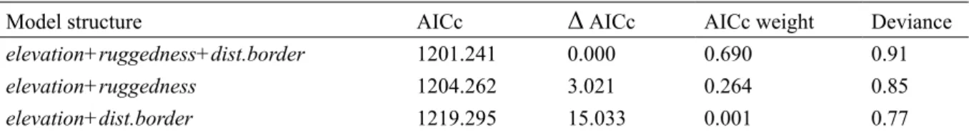
On basis of minimum AICc, the best model determined by RSFs included the variables elevation, ruggedness index, and distance to border, and explained ~91% of the variation in the spatial distribution of argali sheep (Table 1). This model accounted for 69% of the AICc weights among the 7 subset models considered (Table 1). In the top model, argali strongly preferred areas with higher elevation (0.0978 ± 0.0683), rugged terrain (0.0027 ± 0.0001), and distances farther from the international border (0.0534 ± 0.0085; Table 2). The relative importance of the variables elevation (45%) and ruggedness index (39%) were greater than distance to border (16%) for spatial distribution of argali sheep.
Table 1. Model selection results of top 3 ranked models that have AICc weight >0.001 (although 7 subset models were considered), for estimation of factors affecting spatial distribution of argali sheep in western Mongolia
during 2005 – 2010.
Model structure AICc
Δ
AICc AICc weight Devianceelevation+ruggedness+dist.border 1201.241 0.000 0.690 0.91
elevation+ruggedness 1204.262 3.021 0.264 0.85
elevation+dist.border 1219.295 15.033 0.001 0.77
Table 2. Parameter estimates of the top model distinguishing observed and random points explaining spatial distribution of argali sheep in western Mongolia, during 2005 – 2010.
Estimate SE z value p
(Intercept) -5.8324 0.6217 -8.378 < 0.001
Elevation 0.0978 0.0683 4.254 < 0.001
Ruggedness index 0.0027 0.0001 7.327 < 0.001
Spatial predictions from the best model based on elevation, ruggedness index, and distances to border predicted that the study area, including Russian side, contained about 26.5% highly suitable habitat, 37.3% habitat of medium suitability, and 36.2% habitat of low suitability, (Figure 2). Furthermore, about 15.1%, 71.6%, and 13.3% of argali locations occurred in high, medium, and low suitability areas, respectively. When comparing the proportion of argali habitat suitability indices between two countries, the amount of suitable habitat was signifi cantly greater on Russian side compared to the Mongolian side
(χ2 = 48.66, df = 2, p < 0.001; Figure 3).
Overall, habitat suitable for argali varied among border buffer zones and was greatest in Zone 3 (χ2 = 81.81, df = 4, p < 0.001; Figure 4). The mean proportion of high suitability area in each zone was 54 ± 24 SD % (range = 19 – 85%). The greatest proportion of high suitable area (85%) occurred in Zone 3 (i.e. within N50011, E90023 – N50013, E90020) and the smallest amount of high suitability area fell within Zone 5. The smallest proportion of medium suitable area fell within Zone 3 and the largest proportion of medium suitable area occurred in Zone 5. Figure 2. Habitat suitability model for argali sheep within and around the Gulzat Local Protected Area, in
north-western Mongolia.
Chimeddorj et al. Factors affecting distribution of argali in Mongolia 50
Notably, low suitability score occurred only in Zone 5.
Discussion
We present the fi rst analysis of habitat selection by argali inhabiting a region adjacent to the Russia-Mongolia border in northwestern Russia-Mongolia, using locations from individual sheep observed over multiple years. Our results provide a foundation on which to gauge and mitigate issues relating to infrastructure development and disturbance. In our study, habitat selection by argali was best explained by a model that incorporated of the variables elevation, terrain ruggedness, and distance to border. The ruggedness has been well recognized as an integral component in the ecology of mountain sheep (e.g. Rachlow & Bowyer, 1998; Singh et al., 2009). Many mountain ungulates evade predation by fl eeing to precipitous, so called ‘escape’ terrain (Geist, 1971; Namgail et al., 2004). However, build as more of a coursing animal, argali typically descend from escape terrain and fl ee from potential predators (Namgail et al., 2004; Walker et al., 2007). Predators, especially domestic dogs and wolves, represent the leading cause of mortality for argali sheep in Ikh Nart Nature Reserve on the northern edge of Mongolia’s Gobi (Reading et al., 2009). The topographic heterogeneity also affects the amount of solar radiation a site receives; exposed sites accumulate less snow and provide better forage availability. Convex curvatures and more limited plant growth at higher elevations enable mountain sheep to better detect predators by improving sight
lines (Bleich, 1999; Frid & Dill, 2002). However, these were not the only parameters that explained resource selection, and more site-specifi c variation occurred among other parameters. Other factors such as predator densities, distribution of surface water, households and human activity, food quality, and forage abundance also may be important and require further analyses.
The lack of wildlife crossing structures or fence gaps for the existing Russia–Mongolia borders effectively divides wildlife populations inhabiting the regions, including argali. In the case of argali in Mongolia, the border fence prevents the animals from accessing the high quality habitat on the Russian side of the border, possibly limiting population growth. Adequate argali conservation management, therefore requires transboundary cooperation and joint conservation initiatives. Focusing on mitigation measures such as removal of border fences along some segments (e.g. particularly in Zone 3) could represent a reasonable starting point for developing conservation programs aimed at maintaining argali meta-population structure and viability. In the near term argali conservation urgently requires joint international efforts to collaborate effectively with the border defense agencies, local herders, government offi cials, and ecologists. Preliminary efforts to create a transboundary movement corridor have begun (Chimeddorj, pers. comm.), but require additional work at both high and local levels. Conservation measures for argali population also benefi t sympatric populations of ibex (Capra sibirica),
snow leopard (Uncia uncia), and other species. Our results suggest that spatially explicit models based the RSF can help guide identifi cation of corridor areas for free-ranging species and enhance our understanding of the factors affecting species distribution and habitat selection. While such a RSF-informed approach offers an important advance in addressing functional connectivity, there is no guarantee that the identifi ed corridors will ensure population persistence (Taylor et al.,
2006). A fundamental challenge is linking corridor planning with regional landscape management and developing research to identify the contribution of corridors to population persistence (Carroll, 2006). Construction of an impermeable border fence would disrupt an extensive population network of argali sheep. In addition to preventing transboundary movements, that barrier would eliminate or weaken linkages among some populations on the same side of the border. Small population sizes and high environmental stochasticity in populations of argali sheep may experience frequent population extinctions. Detailed demographic data and metapopulation models could shed further light on the probability of local extinctions. Perhaps most importantly, effective conservation of argali sheep and other sympatric species requires creating transboundary protected areas to maintain the biodiversity of the border region.
Acknowledgement
The monitoring study is ongoing under the project funded by WWF Netherland and our work was supported by the Denver Zoological Foundation; Ministry for Nature, Environment and Tourism of Mongolia; and Institute of Biology, Mongolian Academy of Sciences. We would like to thank S. Amgalanbaatar, D. Kenny, R. Mandakh, Ch. Nyamdavaa, WWF Mongolia rangers, for monitoring the collared animals and all of the research assistants who participated in our fi eld work for their assistance with various aspects of our work. We also thank Kirk A. Olson for his constructive comments on previous version of the manuscript.
References
Amgalanbaatar, S. & Reading, R. P. 2000. Altai argali. In: R.P. Reading and B. Miller (eds.)
Endangered animals: confl icting issues. Greenwood Press, Westport. pp. 5-9.
Amgalanbaatar, S., Reading, R. P., Lhagvasuren, B. & Batsukh, N. 2002. Argali sheep Ovis ammon trophy hunting in Mongolia. Pirineos,
157: 129–150.
Atwood, T. C., Young, J. K., Beckmann, J. P., Breck, S. W., Fike, J., Rhodes Jr, O. E. & Bristow, K. D. 2011. Modeling connectivity of black bears in a desert sky island archipelago.
Biological Conservation, 144: 2851–2862. Badam, K. & Ariunzul, Y. (compilers and editors).
2005. Mongolian law on fauna. Ministry of Nature and Environment, Ulaanbaatar. 248 pp. (In Mongolian)
Batsaikhan, N., Buuveibaatar, B., Chimed-Ochir, B., Enkhtuya, O., Galbardrakh, D., Ganbaatar, O., Lkhagvasuren, B., et al. 2014. Conserving the world’s fi nest grassland amidst ambitious national development. Conservation Biology,
DOI: 10.1111/cobi.12297
Begzsuren, S., Ellis, J. E., Ojima, D. S., Coughenour, M. B. & Chuluun, T. 2004. Livestock responses to droughts and severe winter weather in the Gobi Three Beauty National Park, Mongolia. Journal of Arid Environments, 59: 785–796 .
Berger, J. 2004. The last mile: How to sustain long distance migration in mammals. Conservation Biology, 18: 320–331.
Berger, J., Buuveibaatar, B. & Mishra, C. 2013. Globalization of the cashmere market and the decline of large mammals in Central Asia.
Conservation Biology, 27: 679–689.
Beyer, H. 2010. Geospatial Modelling
Environment. <http://www.spatialecology. com/gme>. 14 Accessed 7 Feb 2013.
Bleich, V. C. 1999. Mountain sheep and coyotes: patterns of predator evasion in a mountain ungulate. Journal of Mammalogy, 80: 283– 289.
Bolger, D. T., Newmark, W. D., Morrison, T. A. & Doak, D. F. 2008. The need for integrative approaches to understand and conserve migratory ungulates. Ecology Letters, 11: 63– 77.
Boyce, M. S., Vernier, P. R., Nielsen, S. E. & Schmiegelow. F. K. A. 2002. Evaluating resource selection functions. Ecological Modelling, 157: 281–300.
Chimeddorj et al. Factors affecting distribution of argali in Mongolia 52
practical information-theoretic approach. 2nd edn. New York: Spring–Verlag.
Carroll, C. 2006. Linking connectivity to viability: insights from spatially explicit population models of large carnivores. Connectivity Conservation (eds K.R. Crooks & M. Sanjayan), pp. 369–389. Cambridge University Press, Cambridge.
Chetkiewicz, C. B. & Boyce, M. S. 2009. Use of resource selection functions to identify conservation corridors. Journal of Applied Ecology, 46: 1036–1047.
Clark, E. L. & Javzansuren. M (eds.). 2006. Mongolian red list of mammals. Zoological Society of London, London, United Kingdom. Flesch, A. D., Epps, C. W., Cain, J. W., Clark,
M., Krausman, P. R. & Morgart, J. R. 2010. Potential effects of the United States-Mexico border fence on wildlife. Conservation Biology, 24: 171–181.
Frankham, R., Ballou, J. D. & Briscoe, D. A. 2002. Introduction to Conservation Genetics. Cambridge University Press, Cambridge. Frid, A. & Dill, L. 2002. Human-caused
disturbance stimuli as a form of predation risk. Conservation Ecology, 6: 11–26.
Geist, V. 1971. Mountain sheep: a study in behavior and evolution. University of Chicago Press, Chicago, Illinois.
Harris, G., Thirgood, S., Hopcraft, J. G. C., Cromsigt, J. P. G. M. & Berger, J. 2009. Global decline in aggregated migrations of large terrestrial mammals. Endangered Species Research, 7: 55–76.
Ito, T. Y., Okada, A., Buuveibaatar, B., Lhagvasuren, B., Takatsuki, S. & Tsunekawa, A. 2008. One-sided barrier impact of an international railroad on Mongolian gazelles. Journal of Wildlife Management, 72: 940–943. Ito, T.Y., Lhagvasuren, B., Tsunekawa, A.,
Shinoda, M., Takatsuki, S., Buuveibaatar, B. & Chimeddorj, B. 2013. Fragmentation of the habitat of wild ungulates by anthropogenic barriers in Mongolia. PloSOne, 8(2): e56995. IUCN. 2011. IUCN red list of threatened species.
Version 2011.1. http://www.iucnredlist.org. Downloaded on 07 February 2012.
Johnson, C. J., Nielsen, S. E, Merrill, E. H., McDonald, T. L & Boyce, M. S. 2006. Resource selection functions based on use-availability data: theoretical motivation and evaluation methods. Journal of Wildlife Management, 70:
347–357.
Kaczensky, P., Kuehn, R., Lhagvasuren, B., Pietsch. S., Yang, W. & Walzer, C. 2011. Connectivity of the Asiatic wild ass population in the Mongolian Gobi. Biological Conservation, 144: 920–929.
Lkhagvasuren, B., Amgalanbaatar, S. & Harris, R. B. 2010. Population estimates of mountain ungulates in Mongolia. Institute of Biology, Mongolian Academy of Sciences, Ulaanbaatar, Mongolia. (unpublished report)
Manly, B. F. J., McDonald, L. L., Thomas, D. L., McDonald, T. L. & Erickson, W. P. 2002. Resource selection by animals: statistical design and analysis for fi eld studies. Second
edition. Kluwer Academic Publishers,
Norwell, Massachusetts, USA.
Mueller, T., Olson, K. A., Fuller, T. K., Schaller, G. B., Murray, M. G. & Leimgruber, P. 2008. In search of forage: predicting dynamic habitats of Mongolian gazelles using satellite-based estimates of vegetation productivity. Journal of Applied Ecology, 45:649– 658.
Mukhtogtoh, B. 2012. Population estimate of argali population within and around the Gulzat Local Protected Area. World Wide Fund for Nature Mongolia, Ulaanbaatar, Mongolia. Namgail, T., Fox. J. L. & Bhatnagar, Y. V. 2004.
Habitat segregation between sympatric Tibetan argali Ovis ammon hodgsoni and blue sheep Pseudois nayaur in the Indian Trans-Himalaya. Journal of Zoology, 262: 57–63. Olson, K. A., Mueller, T. M., Leimgruber, P.,
Nicolson, C., Fuller, T. K., Bolortsetseg, S., Fine, A. E., Lhagvasuren, B. & Fagan, W. F. 2009. Fences impede long-distance Mongolian gazelle movements (Procapra gutturosa) in drought-stricken landscapes. Mongolian Journal of Biological Sciences, 7: 45–50. R Development Core Team. 2008. A language and
environmentfor statistical computing. Vienna: R Foundation for Statistical Computing. Rachlow, J. L. & Bowyer, R. T. 1998. Habitat
selection by Dall’s sheep (Ovis dalli): maternal trade-offs. Journal of Zoology, 245: 457–465. Reading, R. P., Amgalanbaatar, S., Mix, H. &
Lkhagvasuren, B. 1997. Argali Ovis ammon
surveys in Mongolia’s South Gobi. Oryx, 31: 285–294.
3: 25–32.
Reading, R. P., Kenny, D., Amgalanbaatar, S., DeNicola, A. & Wingard, G.J. 2009. Argali lamb (Ovis ammon) morphometric measurements and survivorship in Mongolia. Mammalia, 73: 98–104.
Riley, S. J., DeGloria, S. D. & Elliot. R. 1999.
A terrain ruggedness index that quantifi es topographic heterogeneity. Intermountain Journal of Sciences, 5:23–27.
Ripley, R. 2011. MASS: support functions and datasets for Venables and Ripley’s MASS. Available: http://cran.r-project.org/web/ packages/MASS/index.html.
Singh, N. J., Yoccoz, N. G., Bhatnagar, Y. V. & Fox, J. L. 2009. Using habitat suitability models to sample rare species in high-altitude ecosystems: a case study with Tibetan argali.
Biodiversity and Conservation, 18: 2893– 2908.
Tachiiri, K., Shinoda, M., Klinkenberg, B. & Morinaga, Y. 2008. Assessing Mongolian snow disaster risk using livestock and satellite data.
Journal of Arid Environments, 72: 2251–2263. Taylor, P. D., Fahrig, L. & With, K. A. 2006.
Landscape connectivity: a return to the basics. Connectivity Conservation (eds K.R. Crooks & M. Sanjayan), pp. 29–43. Cambridge University Press, Cambridge.
Walker, A. B. D., Parker, K. L., Gillingham, M.
P., Gustine, D. D. &. Lay, R. J. 2007. Habitat selection by female Stone’s sheep in relation to vegetation, topography, and risk of predation.
Ecoscience, 14: 55–70.
Walsh, C. & MacNally, R. 2004. hier.part: Hierarchical Partitioning. R package version 1.0.
Wagenmakers, E.J. & Farrell, S. (2004) AIC model selection using Akaike weights. Psychonomic Bulletin and Review, 11: 192–196.
Wilcove, D. S. & Wikelski, M. 2008. Going, Going, Gone: Is Animal Migration Disappearing.
PLoS Biol, 6(7): e188.
Wingard, G. J., Harris, R. B, Pletscher, D. H., Bedunah, D. J., Mandakh, B., Amgalanbaatar, S. & Reading, R. P. 2011. Argali food habits and dietary overlap with domestic livestock in Ikh Nart Nature Reserve, Mongolia. Journal of Arid Environments, 75: 138–145.
Yu, F., Price, K. P., Ellis, J., Feddema, J. J. & Shi, P. 2004. Interannual variations of the grassland boundaries bordering the eastern edges of the Gobi Desert in central Asia. International Journal of Remote Sensing, 25:327–346. Zahler, P., Lkhagvasuren, B., Reading, R.
P., Wingard, G. J., Amgalanbaatar, S., Gombobaatar, S., Barton, N. & Onon, Y. 2004. Illegal and unsustainable wildlife hunting and trade in Mongolia. Mongolian Journal of Biological Sciences, 2: 23–31.