FACULDADE DE CIÊNCIAS
DEPARTAMENTO DE BIOLOGIA ANIMAL
COMPARISON OF ROCKY REEF FISH COMMUNITIES AMONG
PROTECTED, UNPROTECTED AND ARTIFICIAL HABITATS IN
MADEIRA ISLAND COASTAL WATERS USING UNDERWATER
VISUAL TECHNIQUES
Cláudia Correia da Silva Ribeiro
DOUTORAMENTO EM BIOLOGIA (BIOLOGIA MARINHA E AQUACULTURA)
LISBOA 2008
FACULDADE DE CIÊNCIAS
DEPARTAMENTO DE BIOLOGIA ANIMAL
COMPARISON OF ROCKY REEF FISH COMMUNITIES AMONG
PROTECTED, UNPROTECTED AND ARTIFICIAL HABITAS IN
MADEIRA ISLAND COASTAL WATERS USING UNDERWATER
VISUAL TECHNIQUES
Cláudia Correia da Silva Ribeiro
Bolseira da Fundação para a Ciência e a Tecnologia
(SFRH/BD5307/2001)
DOUTORAMENTO EM BIOLOGIA (BIOLOGIA MARINHA E AQUACULTURA)
Tese orientada pelo Prof. Doutor Armando Jorge Teles e Almeida Tese co-orientada pelo Doutor George R. Sedberry
LISBOA 2008
RESUMO ... I ABSTRACT ...V
CHAPTER 1: GENERAL INTRODUCTION... 1
1.1-STUDIES OF MADEIRAN MARINE FISH COMMUNITIES... 1
1.2-MAIN PRESSURES IN WORLDWIDE COASTAL COMMUNITIES FOCUSING MADEIRA ISLAND... 4
1.3-THE IMPORTANCE OF THE STUDY OF COASTAL REEF FISH COMMUNITIES... 13
CHAPTER 2: OBJECTIVES ... 16
CHAPTER 3: VISUAL CENSUS TECHNIQUES: IT’S IMPORTANCE IN STUDIES OF COASTAL FISH COOMUNITIES ... 18
CHAPTER 4: MPA’S... 21
4.1-CONSIDERATIONS ON MPAS... 21
4.2-GMR: THE FIRST PORTUGUESE MARINE RESERVE... 29
CHAPTER 5: MATERIAL AND METHODS ... 32
5.1-STUDY AREA: GENERAL CHARACTERIZATION... 32
5.1.1 - Characterization of Madeira subidal bottoms ... 34
5.1.2 - Sampling locations ... 36
5.2-SURVEY METHODS... 37
5.2.1 - Transect method (T) ... 38
5.2.2 - Point count or Stationary visual technique (PC) ... 39
5.2.3 - Visual Fast Count Method (VFC) ... 40
5.3–PHYSICAL AND ENVIRONMENTAL VARIABLES... 41
5.4-DATA ANALYSIS... 42
5.4.1 - Methods comparisons... 42
5.4.2 - Fish communities ensemble properties ... 43
5.4.3 - Univariate statistical analyses ... 44
5.4.4 - Multivariate statistical analyses ... 45
5.5.5 - Fish assemblages structure ... 46
FISH GUILDS... 46
a) Trophic structure ... 46
b) Spatial Organization/Ecological Type ... 47
DEPTH DISTRIBUTION ... 47
CHAPTER 6: RESULTS ... 48
6.1-SURVEYS METHODS... 48
6.1.1 - Training program- diver ... 48
6.1.2 - Method comparison... 48
6.2-FISH ASSEMBLAGES... 61
6.2.1 - Species richness and Diversity... 61
6.2.2 - Qualitative Similarity ... 66 6.2.3.- Sighting Frequency ... 68 6.3-ABUNDANCE... 72 6.4-ASSEMBLAGES STRUCTURE... 84 FISH GUILDS... 84 a) Trophic structure ... 84
c) Demographic structure ... 87
DEPTH EFFECT... 90
6.5-PHYSICAL AND ENVIRONMENTAL PARAMETERS... 92
CHAPTER 7: DISCUSSION AND FINAL CONSIDERATIONS ... 96
7.1-FISH CENSUS METHODOLOGY: DISCUSSION AND CONSIDERATIONS... 96
7.2-MADEIRAN INSHORE ROCKY REEFS COMMUNITIES... 105
7.3-STRUCTURE OF FISH COMMUNITIES AND STRUCTURING FACTORS... 113
7.4-MARINE PROTECTED AREA:GMR ... 119
7.4.1 - GMR species updating results... 119
7.4.2 - Reserve effect ... 122
7.4.3 - GMR Management Implications ... 129
7.5-MADEIRA COASTAL FISH COMMUNITIES:IMPLICATIONS FOR MANAGEMENT... 132
ACKNOWLEDGMENTS... 134
REFERENCES ... 135
RESUMO
O presente trabalho visou o estudo das comunidades de peixes dos recifes rochosos da costa Sul da Ilha da Madeira com a finalidade de obter dados de referência sobre a estrutura dos ictiopovoamentos que habitam a estreita faixa rochosa do litoral madeirense. As comunidades foram caracterizadas em termos de riqueza específica, composição, abundância, estrutura trófica, espacial, demográfica e dinâmica sazonal, considerando os factores profundidade, tipo de substrato e localidade. Utilizaram-se três métodos de contagem visuais (transecto, ponto fixo e ”visual fast count”), frequentemente utilizados em estudos semelhantes realizados noutras regiões do planeta, mas que aqui foram pela primeira vez aplicados em simultâneo, testando a sua eficiência e desempenho para avaliação das comunidades de peixes existentes, bem como uma revisão e actualização acerca deste tipo de metodologias. Avaliou-se o grau de protecção das comunidades ictiológicas da Reserva Marinha do Garajau, estimando os eventuais benefícios das medidas de protecção existentes e investigou-se também a influencia de determinadas intervenções humanas como é o caso da implantação de enrocamentos ao longo do litoral madeirense na estrutura das comunidades ictiológicas que estes locais agregam. Pretendeu-se também avaliar e evidenciar uma lista dos maiores problemas associados à gestão dos recursos ictiológicos costeiros da Ilha da Madeira, identificando os parâmetros mais adequados a serem usados em decorrentes projectos de monitorização dessas comunidades.
O período de amostragem decorreu entre a Primavera de 2002 e a Primavera de 2004, em três localidades da costa Sul da Ilha da Madeira, numa área marinha protegida - Reserva Marinha do Garajau; uma área natural não protegida - Caniçal e uma área costeira submetida a intervenção humana, artificial - o enrocamento do aeroporto da Madeira.
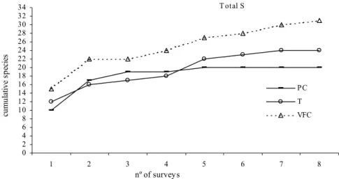
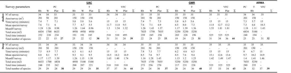
De entre os métodos usados, foi com o “visual fast count” que se registou maior número de espécies em todos os locais, revelando-se o mais adequado na avaliação da riqueza específica duma dada área. No entanto, dado não ter fornecido estimativas de densidades, devido à impossibilidade de quantificar a área amostrada, verificou-se também ter sido conveniente a aplicação dos outros dois métodos (transecto ou ponto fixo), os quais poderão ser aplicados em simultâneo ou cada um per si em futuros programas de monitorização das comunidades de peixes costeiros na Ilha da Madeira.
Num total de 183 mergulhos, completando 185 horas de trabalho subaquático, contabilizou-se 61 taxa pertencentes a 33 famílias, muitas delas representadas por uma única espécie, enquanto 5 famílias compreenderam praticamente 80% do total de espécies observadas. Comparando o total de espécies observadas no presente estudo com o número de espécies referidos para áreas litorais em regiões tropicais e subtropicais, a diversidade de peixes litorais na Ilha da Madeira é consideravelmente baixa, reforçando a ideia de diminuição da diversidade dos povoamentos ictiológicos dos trópicos para as zonas mais temperadas. O facto das águas circundantes serem oceânicas e oligotróficas, com baixa produtividade é uma possível explicação para a reduzida diversidade de peixes observada na ilha. Adicionalmente a sobrexploração dos recursos pesqueiros (uso de práticas bastante destrutivas como os explosivos) e a grande intervenção humana a que a costa da Ilha da Madeira, sobretudo a costa Sul, tem sido sujeita em resultado do desenvolvimento da ilha em termos turísticos, tal como sucedeu no arquipélago vizinho das Ilhas Canárias, são outras possíveis razões para a baixa diversidade observada.
A distribuição das espécies de peixes costeiros na área estudada apresentou elevado nível de homogeneidade, tendo 34 espécies sido observadas nas três localidades. Existe uma dominância espaço-temporal dum pequeno número de espécies que compõem o ‘plafond’ de espécies comuns e que estão presentes independentemente do factor considerado, pelo que qualquer que seja a relação dessas espécies com as variáveis estruturantes da comunidade esse grupo tende a formar uma comunidade estável, sugerindo assim uma ordem estrutural. De entre esse pequeno grupo de espécies salientam-se: Abudefduf luridus, Chromis limbata, Thalassoma pavo, Sphoeroides
marmoratus, Sparisoma cretense que foram de entre as espécies observadas as mais
frequentes e abundantes nos recifes rochosos amostrados ao longo da costa Sul da Ilha da Madeira. Desta evidência de homogeneidade na diversidade e distribuição dos peixes nos recifes rochosos da ilha da Madeira advém informação muito importante para a gestão dos recursos locais.
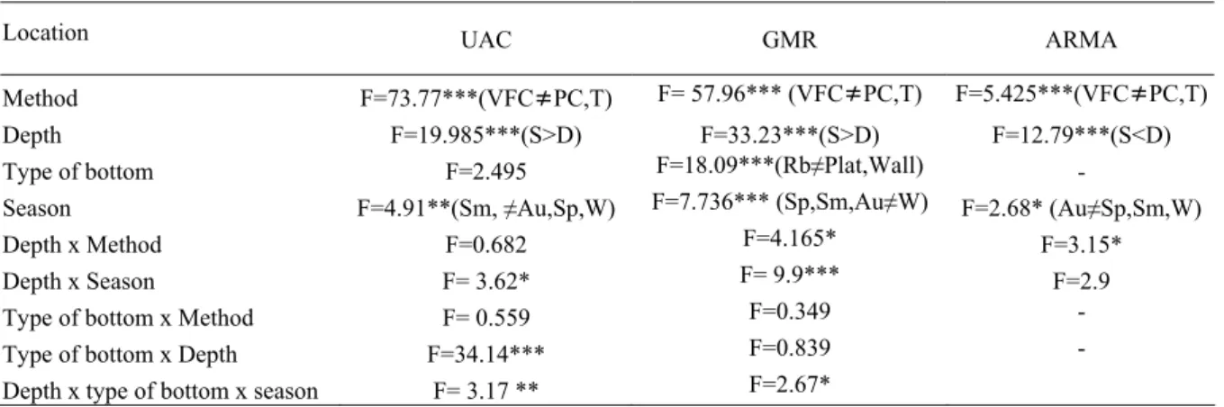
As comunidades de peixes litorais estudadas mostraram estruturar-se de acordo com o tipo de substrato e profundidade. A análise multivariada através de ‘plots nMDS’ revelou uma boa separação das três localidades estudadas, evidenciando também uma clara separação de acordo com a profundidade, registou-se maior número de peixes no intervalo de profundidade 10-20m. Os parâmetros calculados com base nas estimativas visuais das populações de peixes diferiram significativamente entre os tipos de substrato
e também verificou-se um aumento do número de espécies, de abundância, e de alguns grupos funcionais da comunidade de acordo com a profundidade. A análise da estrutura trófica das comunidades de peixes dos recifes rochosos da ilha da Madeira, evidenciou grande dominância dos carnívoros, quer em número de espécies observadas quer em termos de abundância, ocorrendo também uma significativa contribuição da categoria dos omnívoros, enquanto a os herbívoros estiveram sub-representados.
Os resultados obtidos demonstraram que a composição e estrutura das comunidades de peixes litorais dos recifes rochosos da Ilha da Madeira são significativamente influenciadas pela natureza dos recifes, nomeadamente naturais vs artificiais. Verificou-se que o número total de espécies, abundância de espécies demersais, frequência de ocorrência e tamanho dos indivíduos de algumas espécies foram mais elevados nas localidades naturais do que no enrocamento do aeroporto da Madeira.
O factor “protecção” não mostrou ter efeito significativo no total de espécies observadas, enquanto os factores ‘profundidade’ e ‘estação do ano’ foram significativos sobre a riqueza específica e abundância nos locais amostrados. De salientar que o mero,
Epinephelus marginatus, espécie incluída na lista vermelha da IUCN sob a categoria
“em perigo”, foi apenas observado na área da reserva, ainda que em reduzido número e com baixa frequência de ocorrência, o que, tratando-se duma espécie gregária e altamente territorial já era expectável. Todavia, as medidas de protecção estabelecidas na Reserva Marinha do Garajau permitiram em certo grau alcançar alguns dos objectivos propostos a quando da criação da reserva, com um aumento do número de indivíduos de tamanho médio e grande em relação às duas outras localidades amostradas. Adicionalmente, outras espécies exploradas pelos pescadores locais, como sejam o bodião, Sparisoma cretense e o badejo, Mycteroperca fusca foram também observadas com maior frequência de ocorrência e em maior número de indivíduos na área da reserva.
Pese embora o presente trabalho forneça dados de referência com vista ao prosseguimento de objectivos de gestão e conservação dos recursos ictiológicos costeiros da Ilha da Madeira, é necessário continuar com uma eficiente monitorização das comunidades costeiras existentes na ilha, considerando alguns dos factores ponderados no presente trabalho bem como outros, cuja influencia nestas comunidades não foi até à presente data investigada (e.g. processos de recrutamento e fixação das
A escassez de informação acerca das comunidades de peixes costeiros na Ilha da Madeira pode ser referida como uma das razões para possíveis falhas na detecção de efeitos significativos da acção humana sobre as comunidades estudadas. Daí que, os resultados obtidos presentemente em conjunto com os resultados obtidos em trabalhos prévios contribuirão para uma visão mais alargada e um melhor conhecimento das comunidades de peixes costeiros na ilha da Madeira.
ABSTRACT
This study concentrates on fish species associated to rocky inshore reefs of the south coast of Madeira Island in order to obtain base-line data on the structure of the fish assemblages inhabiting the very limited shallow coastal habitats surrounding Madeira Island. The faunistic features of the local fish communities were defined in terms of species richness and composition; abundance; trophic, spatial and demographic structure; and seasonal changes relating to type of substrate, depth, seasons and locations. Three visual-census methods commonly used in similar studies performed elsewhere (transect, point-count – PC and visual fast count - VFC) were used for fish assessment with further comparison and evaluation of efficiency and performance for each of them and other methods. I determined the extent to which Garajau Marine Reserve (GMR) protected different assemblages of reef fishes, the effects of riprap along the shore of the island as fish habitat, and how protection and artificial substate can be used in the management of inshore fish resources of Madeira Island.
Censuses were seasonally conducted (three times/season) during a two-year period from Spring 2002 to Spring 2004 in three locations on the south coast of Madeira Island, including a marine protected area (GMR), a natural non-protected area (Caniçal) and an artificial non-protected area (riprap of Madeira airport).
Methods comparison showed that the total number of species recorded by the VFC was always higher than PC and transects methods in all locations, including all bottoms types and both depth; however the use of standard methods such as transect or point count are valuable for obtaining fish densities estimates and should be used in a future monitoring program.
Diurnally active fishes (61 taxa), belonging to 33 families were recorded. Most of the families were represented by a single species and five families included about 80% of the total of species observed. Considering the total number of species and families recorded in this study, the pattern of fish species diversity in Madeira Island was relatively low when compared with littoral areas of tropical and subtropical islands in the Atlantic. This reinforces the statement that fish diversity characteristically decreases from tropical to temperate latitudes. The fact that Madeira Island has oceanic and oligotrophic surrounding waters coupled with the nearshore environment alterations arisen from increased tourism development and the over-exploitation of fishery
resources through the use of very destructive fishing practices, as happened in the neighbour Canarian archipelago, can explain the reduced species diversity.
From the overall list of species observed, 34 appeared in the entire area of study, revealing high level of similarity in species composition among areas. There was a special-temporal dominance of a small group of species, which composed the group of common species, whatever the location or any other factor considered in the sampling design. In that group of species were included: Abudefduf luridus, Chromis limbata,
Thalassoma pavo, Sphoeroides marmoratus, Sparisoma cretense, as the most common
and abundantly observed. Moreover, the percentage of rare species in the entire area of study was high; 27 species appeared in less than 25% of the visual counts.
Depth and season were significant factors affecting species composition and abundance, but reserve designation did not significantly affect total abundance or mean number of species observed. The present results indicate that species composition and structure of the fish communities inhabiting the rocky reefs of Madeira Island were influenced by reef type, namely natural vs artificial, and the total number of species and the abundance of some demersal species observed in the artificial riprap of Madeira airport were less than in the natural locations studied.
Total abundance inside the reserve was less than in fished areas, mainly due to the presence of large schools of pelagic species outside the reserve. Though the results of this study showed that temporal trend in species richness was not affected by reserve effect, the sites examined in GMR have to some extent met the objective of preserving significantly higher number of matured-sized fish and thereby showing potential spawning stock. Additionally, considering just demersal fish abundance, several species, particularly exploited species such as Sparisoma cretense and Mycteroperca fusca, were more abundant and with higher frequency of occurrence inside the reserve and the dusky grouper, a widely targeted species across its range was exclusively recorded inside the reserve area, but with very low frequency and abundance.
Although this study provided base-line data for ecological management purposes it is essential that further quantitative studies be conducted on densities, size structure as well in settlement and recruitment processes, to fully acknowledge the inshore fish communities inhabiting the island.
The paucity of information obtained till date on reef fish communities of Madeira Island can be highlighted as a failure in the establishment and assessment of the effects of human activities on coastal reefs resources. Hence, the combination of
present results with the existing from few previous works will help to broaden our understanding of the coastal reefs communities of Madeira Island.
Chapter 1: GENERAL INTRODUCTION
1.1 - Studies of Madeiran marine fish communities
Madeira archipelago, due its geographic position as oceanic islands in the eastern Atlantic, is of particular interest to biologists because of its isolation, mode of origin, climatic characteristics and consequent biological peculiarities (Báez, 1993). Besides the intrinsic interest of islands, Madeira particularly had featured strongly the development of evolutionary and ecological ideas from the earliest formal studies (Darwin, 1859). Terrestrial biota has been more extensively studied than the marine environment and the ichthyofauna works were mainly taxonomic. Moreover, the costs and rigorous environmental conditions of the rugged coastline have made the consistent acquisition of sufficient information difficult and the available scientific manpower is often insufficient to generate the amount and diversity of information needed for research or monitoring, as have been referred to other regions in the world (Pattengill, 1998).
The existing works on fishes focus on systematic ichthyology (Lowe, 1843-60; Maul, 1948; Saldanha et al., 1986; Heemstra, 1991). Some were reports on fishes species captured in expeditions, including checklists of the fish fauna (Maul, 1962; Mead, 1964; Maul, 1976; Araújo et al., 2005) and descriptions of fish occurrence to Madeira Island, (Maul, 1969; Araújo & Freitas, 2002; Freitas & Biscoito, 2002; Alves & Alves, 2002), which continue to be reported to date. Indeed, some fish species discovered to occur in Madeira Island in the last few years (e.g. Biscoito & Wirtz, 1994; Alves & Alves, 2002; Araújo & Freitas, 2002; Freitas & Biscoito, 2002) are coastal and not offshore/bathyal where it would be more natural to discover new species (Alves and Alves, 2002). Additional investigations were carried out on particular aspects of certain fish species (Morales-Nin & Sena-Carvalho, 1996; Andrade et al., 1998; Costa et al., 1998) and in the biogeography of the Macaronesian ichthyofauna (Lloris et al., 1991). Guides to fishes and invertebrates from Madeira archipelago are also available (Wirtz, 1994, 1995b; 2001; Araújo & Calado, 2003), whilst few studies have dealt with the littoral zone and undertaken on the classification of marine communities in the island (Augier, 1985; Bianchi et al., 1998; Neto et al., 2001). There are few quantitative surveys conducted about community structure, mostly of the habitats remaining poorly described and historic data on population densities for reef-associated species in
According to Bianchi et al. (1998) the hard-bottom littoral communities of the whole Macaronesia are poorly known with the exception of the Canaries (Brito et al., 2002). Morato et al. (2003) noted that little work has been done on the populations inhabiting the shore habitats of the north Atlantic oceanic islands and Hawkins et al. (2000) reinforced that much work remain to be done on Macaronesia shores and that they are calling for further studies.
Only five studies on fish assemblages assessment using the visual census methodology have been carried out in Madeira (Andrade & Albuquerque, 1995; Bianchi
et al., 1998; Delgado, 1998; Mello, 2000; Ribeiro et al., 2005). Additional papers have
been published on some of the islands of the Macaronesia Region (Báez & Sánchez-Pinto, 1983; Beyhl et al., 1995): Azores (Azevedo, 1995; 1997; Harmelin-Vivien et al., 2001), Desertas (Ré, 1978) Selvagens (Falcón et al., 2001), Canary Islands (Bortone et
al., 1991; Falcón et al., 1996; Bianchi et al., 2000; Hajagos & Van Tassel, 2001) and
Cape Verde Islands (Brito et al., 1999). Also lacking are data regarding the structure of fish communities in the marine reserves of Madeira archipelago, and despite the importance of Garajau Partial Nature reserve (hereafter named GMR), as the first exclusive marine reserve in Portugal, the literature on its communities and environment is scarce. Delgado (1998) reported a list of fishes and invertebrates in GMR through underwater sightings and Mello (2000) reported a list of fish recorded in transect surveys performed in the bay that gives name to the reserve (Garajau bay). Concerning the other marine reserves in Madeira archipelago, there is a small note on the littoral fish fauna of Desertas Islands, long before reserve establishment (Ré, 1978) and Falcón
et al. (2001) presented a checklist of inshore fishes of Selvagens Islands, obtained
during the expedition Macaronesia 2000. Therefore, this current lack of information about the marine resources of Madeira coastal reefs, causes difficulties in the assessment of human impacts on these assemblages, as been pointed by several authors in other regions of the world (Otway, 1995; Connell & Lincoln Smith, 1999). That fact should be target of concern due to recent increase in the level of human activities on the marine environment in the world, including Madeira Island. There is an urgent need for obtaining information on fish assemblages structure and of other marine resources in order to identifye the effects of human activities on them.
The issue of nature conservation and sustainable use has been in certain level a matter of concern in Madeira archipelago. Indeed, the first Portuguese natural reserve was created in Selvagens Islands in 1971 in order to preserve the islands from the
exploitation that was suffering, mostly the bird life (Mendes et al., 2000). Despite being one of the most densely populated regions in Europe, Madeira Island has more than 60% of the island declared as Nature Reserve Park. In 1982 the Regional Government of Madeira declared approximately two thirds of the main island as natural park: Parque
Natural da Madeira (hereafter PNM) with a prohibition on capture or disturbance of
native species. Besides PNM, in Madeira archipelago there are also protected areas that included marine environment (MPA – marine protected area) (see Figure 1 and Table I). So far, four MPAs have been established in the archipelago, demonstrating the interest in the protection of privileged areas and in heritage preservation (Freitas et al., 2004). Nevertheless, even when the political will exists to manage coastal resources, governments and communities often lack the skills and necessary resources for effective management (Roberts, 1997) and without an effective enforcement and people “education” about the importance of resources conservation, the results of MPAs creation will be minors (see chapter 4 for more details on MPAs).
Table I - Marine Protected Areas in Madeira Archipelago a - Exclusively marine reserves; b - Biogenetic reserve by the European conseil; c- Classified by the European conseil
Marine reserves in Madeira archipelago have been established for many years, (e.g. Garajau Marine Reserve was created 20 years ago) and inherently provide several roles, but there’s no quantitative information on the marine resources they protect, neither publications showing the efficacy of this course of protective action, nor demonstration about the ways fish and remaining marine resources are affected by reserve management strategy. In fact, concerning their impact over the littoral fishes, there’s no quantification on the benefits they may provide, neither considerations about optimal approaches for their design and management. As previously referred, only Bianchi et al. (1998), Delgado (1998), Mello (2000) and Freitas et al. (2004) referred
Area (km2) Sea land total
Protected area Established Management Enforcement References
Garajau Partial Nature
Reserve (GMR)a 1986 3,76 PNM (Madeira Government) During the day only Castro et al, 1985 Delgado, 1998
Mello, 200 SRARN, 2004 Sítio da Rocha do Navio
Nature Reserve a 1997 3,1 14 17,1 PNM (Madeira Government) Negligible SRARN, 2004
Ilhas Desertas Nature
Reserveb 1990 82,49 14,23 96,72 PNM (Madeira Government) During the day only Ré, 1978
Ilhas Selvagens Nature
some description of benthic and fish communities from GMR and Falcón et al. (2001) provided a basic list of the littoral fishes from Selvagens. Furthermore, many scientists and managers now accept that an ecosystem approach is needed to evaluate the establishment of marine or fish reserves. Efforts have been made in many forum to explain the ‘ecosystem approach’ is an evolution in the management of human activities in the seas and not a revolution (Rice, 2005). Thus, to achieve that type of management, information on resources and their interdependencies is required, including potential trophic interactions (Watson et al., 2000). Since till date, such studies have yet not been conducted in Madeira Island and evidences available from reefs environments from other regions cannot reliably be generalized to the type of existing marine reserves, it is really important the development of marine resources assessment studies on the marine reserves existing in Madeira archipelago. Furthermore, the evaluation of the effectiveness of measures implemented in the marine protected areas is an essential step for developing sustainable conservation strategies (Allison et al., 1998).
1.2 - Main pressures in worldwide coastal communities focusing
Madeira Island
The habitats and their fish assemblages are potentially affected by several anthropogenic pressures, which may have a direct influence on food resources either in terms of distribution, abundance, growth, survival and behaviour. Hence, habitat is relevant to how the environment affects the resources used by humans, how humans change the ecosystem and to view management as an integrated task of planning and managing, rather than a piecemeal activity-specific and jurisdiction-specific regulation (Rice, 2005).
Habitat disturbance by fishing activities has been referred as the dominant anthropogenic effect on the marine environment (Dayton et al., 1995; Jackson & Sala, 2001). In effect, Macaronesia shores have been heavily exploited for food since colonization of the islands by people: the Guanche and subsequently the Spanish in the Canaries; and the Portuguese in the Azores and Madeira (Hawkins et al., 2000). Fishing has a long tradition in Madeira Island and has been an important factor in the success of human colonization in the region (Mendes et al., 2000). For many years fish resources in Madeira Island were exploited by a small artisanal fishery that harvested manly the deep-see resource, the black scabbard fish, Aphanopus carbo, tunas (mainly Thunnus
obesus, Kwatsamus pelamis and T. alalunga) and pelagic species such as Trachurus picturatus and Scomber japonicus. These three sectors compose the largest fraction of
the fishery production, while the fishery along shallow bottoms of the island is multi-species and entirely artisanal as in the neighbour Canarian archipelago (Tuya et al., 2006). The use of gill nets has been discouraged and in the last decade no licenses have been issued by the regional fisheries department for this gear. Hook and line, traps and spears are the commonly type of gears used, catching a wide number of species including sea breams (Pagrus pagrus, Diplodus spp., Dentex gibbosus), parrotfish
(Sparisoma cretense), small groupers (Serranus atricauda) among others. However
these catches represent a small fraction of the total fished resources, namely 10% (by weight) according to 1997 data (Mendes et al., 2000). Additionally, the use of illegal fisheries with explosives were common in Madeira coastal waters (Castro et al., 1985) and that type of fishing practice was habitat destructive, having repercussions on the environment and all biological community. Besides the fish catches, limpets (Patella
aspera and P. candei) have also suffered from heavy exploitation in Madeira
archipelago.
The use of inappropriate fishing gears such as trammel nets and explosives, raw sewage discharges, sand mining and land discharges are all activities occurring along Madeira Island coast and therefore, affecting the marine environment. For instance, Wirtz (2005) describe a large and dense sea grass meadow that existed in Machico bay, that has now disappeared completely, since the extension of port and its piers had changed the current system in the bay and the river had discharged large amounts of mud over the area. Although the absence of more biological data to describe this situation in Madeira Island, this same type of habitat impact have been reported to the neighbour Canarian archipelago ( Bacallado et al., 1989; Bortone et al., 1994) where the same type of inshore activities occurred and where habitat and faunal similarities between archipelagos exist.
Although fishing is an ancient activity in Madeira island, this activity has low weight on the economic structure either in terms of production (1.5% of the gross domestic product) and in terms of employment (Mendes et al., 2000). Nevertheless, the fishing value and relevance overwhelms the economic indicators, either by the food resources it generates and its quality, assuming particular importance in insular regions, as for the turistic attraction associated to fisheries.
Although Madeira has a vast EEZ (exclusive economic zone) about 500 times the terrestrial area, its fishery resources are not very abundant due the features of the ocean bottom, which include the almost inexistent continental shelf, and the low primary production that is typical of an oceanic region without upwelling. The vulnerabilility of the inshore marine resources of the island can be considered even greater due its volcanic origin that lead to the narrow continental shelf, confining coastal reef fish populations to few kilometers from shore (in about 0.5 to 1km). In that sense, information on the levels of fishing pressure (artisanal, illegal, etc.) and other human pressures along coastline is pivotal to the interpretation of spatial patterns of reef fish and it’s importance determining on reef fish communities have been widely emphasized in other regions of the world (Ferreira et al., 2004).
Human presence has increased in most natural habitats of the globe (Garrabou et
al., 1998), inducing habitat loss caused by coastal reclamation and development with
associated pollution that lead to changes in water clarity, sediment loading and added nutrient input (Short & Wyllie-Echeverria, 1996). Madeira Island is no exception and recent hotel, tourism and urban development lead to excessive growth with direct impact on the marine environment. Indeed, tourism and recreation-related activities and developments have been recognized as one of the main pressures on coastal seas (Jones, 2002). The increased anthropogenic pressure in Madeira Island has placed new and unprecedented demands on the coastal marine resources with the continuous degradation of inshore habitats. The coast have been extensively altered in the last decade by artificial harbours, marinas, ripraps, beaches and hotels, has happened in the neighbour Canarian archipelago (Hajagos & Van Tassel, 2001).
Development often involves modification or “armouring” of shorelines, defined as the placement of bulkhead, seawalls and riprap in areas that lack substrate. These structures can extend from the subtidal zone through the intertidal and into purely terrestrial realm, oftening replace more than half of a bay’s natural shoreline. In effect, extensive artificial rocky habitats in the form of rock groins, revetment walls and wharves have been built along Madeira Island coast. The rubble mounds are well known for being protective barriers against undesirable sea conditions and resultant erosion effects and are also known to introduce modifications on the shore and also as an effective aggregating device for marine organisms, especially fishes (Carlisle et al., 1964; Johnson & Wit, 1978), even though they were not originally designed to do so (Burchmore et al., 1985). Thus, in Madeira Island, several structures rubble mounds
alike have been implemented on the shore, some of them to protect beaches (Ponta Delgada, Porto Moniz, etc.) or to create artificial beaches (Calheta), others were deployed in constructions such as marinas (Marina da Quinta do Lorde - Caniçal, Marina do Lugar de Baixo – Ponta do Sol, Marina da Calheta) or to extend the land, has in Madeira airport construction (Figure 2). The environmental precautions taken in those coastal interventions were minor, with silt and land being dumped on the sea and no consistent environmental impact studies performed. Furthermore, the deployment/construction of several ripraps or harbours along Madeira coast (Caniçal, Machico, Airport, S. Pedro – Santa Cruz, Porto Novo, Reis Magos – Caniço, Ribeira Brava, Ponta do Sol, etc. see Figure 3) lead to strong alterations on the shore with aesthetical changes, wave movements, bottoms morphology and in biological communities. These armoured structures are usually primarily designed as shoreline support and though few exceptions, little consideration has been generally paid to the ecological consequences of armouring. Thus, ecological roles and characteristics of armoured biota are poorly documented in many places of the world (Davis et al., 2002), which is the case of Madeira Island, where there is no previous reports about marine communities associated to the locations where these ripraps were deployed/constructed along the shore.
ARs have been used for a variety of purposes: to provide new habitat that will theoretically increase numbers and biomass of depleted fish populations, directly improving recreational and commercial fishing opportunities; they were also been used to possibly mitigate other human activities (Grant et al., 1982; Grove, 1982; Matthews, 1985). Moreover, structures such oil, gas platforms and breakwaters and other structures to control beach erosion serve secondarily as artificial reefs (Raymond, 1975; Wang, 1978), which is the case of the riprap of Madeira airport (ARMA).).
Additional man-made or artificial reefs (ARs) have been created by placing suitable long-lived, stable and environmentally safe materials (usually steel or concrete) on a selected area of the ocean bottom or coast. Indeed, that was the case in Jardim do Mar (Southewest coast of Madeira Island) where the regional fishery department deployed concrete ARs in the year 2000 and in the same year in Porto Santo Island it was thunk a wreck, “o madeirense” an AR that is now searched for many scuba divers, spear and recreational fishers (pers. obser). Generally, these structures are placed on sandy bottom areas that would originally support low density fisheries or in areas where
way that naturally occurring rock outcroppings do in providing hard substrates necessary in the basic formation of a live-bottom reef community (Lindquist et al., 1985). That fact is not new and most fishermen know that the best place to find fishes is around a structure, such as a fallen log in a stream, a shipwreck or an artificial reef (Gratwicke & Speight, 2005). Thus, human intervention via creation of artificial habitats adds complexity to the aquatic environment (Bortone & Kimmel, 1991) with a significant modification of the natural environment and its use has moved from attempts to simply increase recreational fisheries to include using the structures to manage multiple facets of the marine environment, as resource for protection and preservation, tourism, mitigation, fish and invertebrate recruitment and production (Seaman, 2000). Obviously the ability to use the artificial reef structures effectively in order to accomplish the diverse goals will depend in turn, on the understanding of the potential interactions between the structure itself and the immediate environment in which they were placed (Sherman et al., 1999).
Strong conflicts happened in 2003-2004 with surfers and the ecologist organization COSMOS against Madeira politicians and developers. “Save the Waves Coalition” organization “fought” with Madeira government authorities in order to avoid what they call today as the “Lost Jewel of the Atlantic”. Indeed, this organization realized a movie titled “The Lost Jewel of the Atlantic” highlighting the consequences that the seawalls built in Jardim do Mar, Lugar de Baixo and Ponta Delgada had on wave movements and the repercussions in terms of surf and in some degree in surf-tourism-related.
Figure 1 - Madeira archipelago with the protected areas under regulation of Parque Natural da Madeira and GMR.
After deployment of any structure (ARs or ripraps), it become interactive (positively and/or negatively) with surrounding habitat and therefore introducs a source of variation in natural habitat (Bortone & Kimmel, 1991), creating a physical discontinuity in bottom that causes several physical and biological modifications on the environment (Charbonnel et al., 2001). This new substrate is thereby available to be colonized and consequently comparison of fauna and flora of those artificial with natural reefs is needed and is an inevitable consequence of the human comparative process and a worthwhile endeavour (Bortone & Kimmel, 1991). Therefore, one of the
present project purposes was to describe the fish assemblage associated with such an artificial structure, determine how it functioned as fish habitat and compared its fish community to nearby natural reefs. Indeed understanding how fish species are attracted to these structures could help in the future to incorporate specific design changes in attempt. For instance, Hastings (1979) studying the fish fauna inhabiting rubble-mound structures along the gulf of Mexico Atlantic coast of the United States, recommended that jetties should be structured to provide maximum hard substrate availability and in deeper depths.
Figure 2 – Madeira Airport landing strip construction. More than half width of the landing strip was from landfill in the sea.
Besides the aforementioned causes of environmental degradation in Madeira shore, there are also: 1) sediment extractive activity (sand) occurring along the South coast of the island, with dredge boats pumping sediment from the near shore sand bottoms; 2) strong runoff and discharges of sediments in stream mouths that cause a huge decrease in water clarity, with ”brown waters” for many days affecting subtidal communities, mostly algae that depend on the light and thus influencing the entire communities, since macroalgae presence can in turn affect densities of fishes (Choat and Ayling, 1987). Significative changes in the nature of the bottoms also will occur, with rocks getting covered by sand and thus losing habitat complexity. This fact has indirect effects in diversity and abundance, since inshore sandy substrata are homogeneous environments that often support fish populations with lower abundance and richness than the nearby rocky substrates with higher structural complexity (Guidetti, 2000; Guidetti et al., 2002b). Thus, conservation and management of marine resources in Madeira Island face a major problem that is to balance the human extractive activities and habitat destruction against the capability of the ecosystems replenishes and it sustains the resources.
Most impacts occur in coastal seas where the majority of critical areas for ecosystem functioning and productivity are found. Therefore, the protection of such critical areas is of paramount importance (Agardy, 1997) and some authors go further claiming for iniatives to restore coastal marine ecosystems back to their original states than using more recent “shifting baselines” as restoration targets (Jackson & Sala, 2001; Pitcher, 2001). In fact, according to Jackson and Sala (2001) such ambitious measures are necessary to restore ecosystem resilience to other anthropogenic impacts, such as eutrophication and global warming. The anthropogenic disturbance and climate change have caused dramatic shifts in the organization and structure of many coastal communities, with the establishment of alternate stable states (Knowlton, 2004). However, for the majority of the observers of coastal seas, most of the adverse effects of disturbance are not apparent and even for people that are aware on the adverse effects of certain uses, our lack of familiarity and empathy with most marine life and its general lack of intrinsic appeal, mean that the reaction is more likely to be one of indifference. There is a societal perception problem in this respect and many people do not appreciate the importance of marine ecosystem goods and services (Peterson & Lubchenco, 1997), coupled with the fact that marine populations do not follow familiar seasonal patterns and that sea itself is also often seen as an adversary. Nevertheless, it is important to remember that such alienation and perception hurdles can also positively affect and influence human perception of the seas, with many people having a particular interest in marine life because it is unusual, mysterious and unpredictable (Kenchington, 1990). Unfortunately, human behaviour related to the sea is largely defined in terms of the resources it provides, particularly as a place to harvest fish, dilute and disperse liquid wastes and undertake marine navigation (Cole-King, 1995) and therefore marine ecosystem conservation is generally a low societal priority (Jones, 2002).
The overwhelming value of biodiversity as an indicator of environmental health and in the functioning of ecosystems is now largely recognised by academic scientists, mass media, decision makers and public opinion (Bianchi & Morri, 2000). Moreover, one of the ecological tenets justifying biodiversity conservation is that diversity begets stability and therefore, biodiversity can represent a form of biological insurance against the loss or poor performance of selected species (Tilman et al., 1994). Furthermore, and more specifically, there is a growing awareness of the high value of coastal seas in terms of the ecosystems services they provide (Constanza et al., 1997), leading to calls
and widespread process of degradation of marine biota, reducing habitat availability for species (Tilman et al., 1994), altering ecosystems structure and functioning (Gessner et
al., 2004) with further modifications of marine fish communities has the negative
potential to threaten biodiversity (Vanderklift et al., 1998; Roberts & Hawkins, 1999). Some authors identify the rate of loss of biodiversity as a cause for alarm (Walker, 1995) and the evidence of marine biodiversity decline has been noted world-wide (Pauly & Watson, 2003). In effect, regional ecosystems such as coastal (Jackson et al., 2001) and oceanic (Worm et al., 2005) fish communities are rapidly loosing populations, species or entire functional groups.
Major changes in communities might only be detectable over long periods through long time-series that may suffer from inherent changes in survey methodology (Trenkel et al., 2004). In spite of methodology problems, because of fishes’ dependence on specific types of habitats and food, alterations that are detected over time in their distribution and abundance may indicate significant environmental change. Warwick (1993) determined that the aquatic flora and fauna associated with temperate rocky reefs are relative diverse, abundant and sedentary and therefore regarded as suitable indicators of environmental changes. The perturbations in marine system resulting from human activity have resulted in habitat change and species loss with several authors reporting that fish assemblages may respond to disturbances such sewage discharges (Grigg, 1994; Chabanet et al., 1995) and alterations of benthic substrates (Shepherd et
al., 1992; Lewis, 1998). Alterations of rocky habitats have been also shown to induce a
marked decrease in species richness, abundance and size of the associated fishes (Lewis, 1997; Samoilys, 1998 Jennings & Kaiser, 1998). The fundamental alterations to ecosystem structure include changes in species diversity, abundance, size structure, sex ratios and behaviour, habitat structure, trophic dynamics, biogeochemistry and biological interactions (Lubchenco et al., 2003). These alterations are often an indication of underlying ecological changes (Hughes, 1996) and therefore, it is important that conflicts between conservation and exploitation are solved if the goal of sustainable development and protection of natural resources are to be assured. Indeed this worldwide exploitation of marine organisms has prompted actions to minimize the decline of economically valuable populations (Tuya et al., 2000).
1.3 - The importance of the study of coastal reef fish communities
Natural assemblages and populations have been widely used in applied ecology to detect human impacts in marine environments (Warwick, 1993). Generally the approach has been the measurement of a biological variable associated with enviromental impact and monitors it in time and space (Guidetti et al., 2002a). Fishes, that are often a major component of tropical and subtropical faunas are amongst the most diverse vertebrate assemblages in the world (Caley, 1995) and have been more particularly focus of monitoring and management programmes to evaluate the condition of exploited assemblages and have also been extensivly studied in reef communities (Hatcher et al., 1989). Additionally, the fish fauna is an effective reference point for the assessment of the efficacy of MPA management (since fishes are target of exploitation) and represents a main attraction of recreational activities such as scuba diving (Tunesi et
al., 2006). The growing demand for appropriate management strategy and enforcement
of the existing regulations led to an urgent need to obtain baseline data on regional faunal assemblages. In fact, it has become apparent that much of the information necessary to set in place properly constructed management strategies does not exist (Craig et al., 2004). Hence, abundance estimation have been central in many ecological field studies (Thompson & Mapstone, 1997), with baseline data on fish assemblages needed to establish resource management guidelines in order to evaluate the responses of these assemblages to man-made or natural perturbations and also to assist ichthyologists in locating a specific population. These non-manipulative studies provide descriptions of ecosystems structure and temporal dynamics and are used to explore hypothesis (Sale et al., 1994). Furthermore, the study of oceanic island communities due their isolation has been of great importance for development of current concepts of biological evolution and biogeographical theories (Báez, 1993). Besides all these reasons, it is extremely important to produce basic knowledge in terms of diversity and abundance of local resources, in order to develop precise models and thus achieve better understanding of the local rocky shore reefs systems. Therefore, for management of natural resources, monitoring programs are valuable to documenting the status of systems and very important to sustain the local preservation effort in the future (Ferreira
et al., 2001).
Rocky reefs supply food resources, nurseries and shelters to a variety of organisms, sustaining biodiversity due three-dimensional complexity (Turner et al.,
1999). Therefore, degradation of these systems could have negative resonance in the whole coastal biota and strong socio-economical implications (Witman & Dayton, 2001). The fish assemblages of Madeira littoral rocky reefs additionally have an intrinsic value of economic revenue to the island, through artisanal fishery and underwater tourism, which is a growing sector. Moreover, the coast of Madeira provides unique conditions for the development of science, recreation and tourism (Freitas et al., 2004).
Extensive literature about coral reef fishes exists (e.g. Sale, 1980b; Sale et al., 1994), but only few have been done in temperate rocky habitats (Falcón et al., 1996; Guidetti & Bussotti, 2000). Temperate reefs are useful models for studying structure of reef assemblages because they have a fairly comparatively easy taxonomy, with fewer problems in fish identification than with benthic invertebrate fauna identification (Warwick, 1993). Indeed, the ease with which fish species can be recognized in the field makes them an inexpensive source of comparison, and one that can be acquired rapidly (Bond et al., 1999). Besides that, they allow the use of underwater visual methods, techniques which are fast and effective standardised procedures for collecting quantitative data in situ (Harmelin-Vivien et al., 1985), regularly used by researchers (Denny & Babcock, 2004).
Reefs are structures composed by a variety of natural and artificial materials. Natural reefs can be composed by living materials such as sponges, hard corals, and vegetation and also by dead materials such as submerged logs, sipunculid worm casings or nonliving material such as rocks, natural deposits, hardened volcanic extrusions, and other geologic formations. The hardbottoms covered by macroalgae represent an important source of primary production often sustaining well diversified animal communities, that includes fishes (Choat & Ayling, 1987) and can even exert the crucial role of nursery grounds for many fish species (García-Rubies & Macpherson, 1995), providing substrate heterogeneity and physical relief (Bortone & Kimmel, 1991). The reef areas are generally more complex than sea grass and algal beds and obviously more complex than sandy areas. This habitat complexity as been largely recognized as one of the factors affecting diversity, distribution, abundance and trophic organization of rocky reef fishes (Ebeling et al., 1980; Angel & Ojeda, 2001). More complex habitats as would be expected support more fishes, a pattern that has been noted by several authors (Ebeling et al., 1980; Sedberry & Carter, 1993; Mateo & Tobias, 2001; Gratwicke & Speight, 2005). Indeed, the increase in complexity reflects not only the potential shelter
sites available for fishes and their prey, but also the surface area available for occupation by algae and invertebrates (Luckhurst & Luckhurst, 1978). Ebeling et al. (1980) demonstrated that more complex rock-reef surfaces harbour greater diversity and abundance of reef fishes and despite their lower complexity when compared to coral reefs, rocky shores can also support a rich reef fauna and flora. According to Gratwicke & Speight, (2005) complex habitats are best for increasing local fish species richness, but it should be remembered that all habitat types, regardless of their complexity, are important in maintaining regional fish diversity because some fishes use different habitats types at different stages of their ontogenetic development (Sedberry & Carter, 1993), whilst others are habitat specialists (Kirsch et al., 2002).
The structural complexity of coastal habitats has been shown to play a major role in structuring fish assemblages (García-Charton & Pérez-Ruzafa, 1999b; Guidetti et al., 2002a; García-Charton et al., 2004) and studies examining fish distribution across reefs environments have found the habitat structure as having a major influence on distribution and abundance patterns (Russ, 1985; Choat & Ayling, 1987). Although space may be ultimately limiting factor, since reefs are a patchy resource, many reef fish populations are not at the carrying capacity of their environment because abundance is infuenced by a variety of physical and biological influences on settlement from the plankton (Victor, 1983; Richards & Lindeman, 1987; Doherty & Williams, 1988) and early post-settlement mortality (Sale & Ferrel, 1988). Despite the role of reef structure, as a determinant of community structure for resident reef fishes (Risk, 1972; Gladfelter
et al., 1980) others view reef structure as playing a relatively minor role in comparison
to the process of recruitment (Sale & Dybdahl, 1975; Sale, 1980a; Alevizon et al., 1985). There is a increasing suggestion that single-factor explanations for fish assemblage structure are inadequate, focusing on the relative importance of factors that can act at different spatial scales (Bennett & Moyle, 1996). Today, it is widely recognized that communities of fishes are determined by several interacting factors, including recruitment from the planktonic larval phase, interactions among the species and the history of disturbances (Russ & Alcala, 1998).
Chapter 2: OBJECTIVES
This study concentrates on species associated to rocky coastal/inshore reefs, common habitats along Madeira Island shore that consequently suffer from human pressure, exploitation and environmental degradation. Thus, the purposes of the present study were:
1) Provide reference qualitative and quantitative data on the structure of fish communities in common rocky habitats in the protected area of GMR, in a common natural unprotected costal area of Madeira, and in a artificial unprotected riprap from the several occurring along the Madeira coast; and to evaluate the short term variability of the icthyofauna for further monitor possible changes in the structure of these communities.
2) Define the faunistic features of local fish communities in terms of abundance and species richness relative to sea-bottom type in the three locations; and investigate whether locations differ significantly in the fish assemblage and if there were seasonal changes either in abundance, species richness and composition.
3) Compare and evaluate the efficiency and performance of three visual-census methods (transect, point count and visual fast count) which have been commonly used elsewhere and firstly simultaneously used for fish assessment in the rocky bottoms of Madeira Island.
4) Determine the extent to which Garajau Marine Reserve protects different assemblages of reef fishes, assessing possible protection effects, estimating benefits from protection measures in certain target species and assess the importance of GMR as habitat for marine fishes.
5) Determine how a riprap placed in a typical zone of Madeira shore it function as a fish habitat and how the fish community differed from the natural rocky reefs of the other two locations surveyed in the south coast of Madeira Island.
6) Examine the effect or the role of the factors: location, depth, bottom type and seasons in shaping/structuring and maintaining the rocky reef fish assemblages.
7) Provide a set-up of the problems associated with the management of coastal fish resources of Madeira Island and assesses the current status of the GMR as a fishery and habitat conservation tool and therefore select some easily assessed parameters for monitoring, updating current research activities in the MPAs and provide a framework
for future management decisions and also examine the rationale of an expansion or continuity of the MPAs program in Madeira Island.
Chapter 3: VISUAL CENSUS TECHNIQUES: IT’S IMPORTANCE IN STUDIES OF COASTAL FISH COOMUNITIES
Historically fish communities assessments were carried via destructive techniques such as explosives and poisoning (Gosline, 1965; Smith & Tyler, 1973; Chave & Eckert, 1974; Russel et al., 1978) or using typical collecting gears such as trawling (Bardach, 1959). However, these destructive methods result in deleterious impacts as death of many fishes and other organisms and often physically change the habitat. Consequently, these approaches turn out unacceptable for intensive studies of fish assemblages and they should not be repeated and used in the same area (Lipej et al., 2003). Moreover, the spatial irregular biotopes and high physical relief preclude the use of these conventional surface-tended collecting devices such as trawling and dredging to quantitatively sample reef fishes assemblages (Bortone et al., 1986).
The development of SCUBA diving gear and related techniques had greatly facilitated the collection and sampling of reef fishes, using the underwater visual census techniques (hereafter UVCTs). Indeed, immediately after the advent of SCUBA diving its potential for scientific observation of the marine environment was realized and therefore researchers no longer needed to rely only on “blind” methods and could actually see their object of study in its natural environment (Azevedo, 1995). This sampling method was firstly used by Brock (1954) to count Hawaiian reef fishes and has subsequently become widespread (Chave & Eckert, 1974; Hobson, 1974; Sale & Douglas, 1984), forming the basis of most studies on reef fish ecology (Willis, 2001). The majority of recent ecological surveys associated with shallow subtidal reefs involve sampling by diver (Edgar et al., 2004). Furthermore, the UVCTs are the most practical non-destructive way to assess populations of fish associated either to rocky or coral reefs (Bell et al., 1985) and this non-destructive nature makes it appealing to workers conducting repeated observations (Willis, 2001).
Transect is the oldest (Brock, 1954; Bardach, 1959) and the most frequently used method for visually surveying fishes and macro-invertebrates (Thresher & Gunn, 1986; Bortone & Kimmel, 1991). Many workers have used visual census on strip transects (Slobodkin & Fishelson, 1974; Sale & Sharp, 1983; Harmelin-Vivien et al., 1985), which are essentially modifications of Brock’s technique. Generally it have been accepted as being the most quantitative visual assessment technique (DeMartini & Roberts, 1982) with a great practical advantage over other methods since it can rapidly censuses diverse and abundant assemblages across large spatial scales. Though affected
by variation in fish detectability (Thresher & Gunn, 1986), its biases are generally systematic and probably not as great as widely perceived (Edgar et al., 2004). After transect development other techniques appeared, including quadrats (Hastings, 1979), patch counts (Molles, 1978), species-time rapid visual techniques (RVT) (Jones & Thompson, 1978), which can be suitable when the desired goal is only to rapidly produce a species list (Bohnsack, 1982); visual fast count technique (VFC) (Kimmel, 1985) and the stationary visual census technique or point count (PC) (Bohnsack & Bannerot, 1986).
The UVCTS have been considerably modified and adopted by a number of workers and among the many alternatives for gathering data, they were regularly used by researchers has an important tool of fish ecologists; non-destructive and generally cost-efficient method to quantify reef fishes, estimate their sizes and study their distribution. Nonetheless, as Sale and Douglas (1981) referred they seldom completely sample the fish assemblages at a site, but according to Brock (1982) although the most criptical as well the most abundant species were underestimated, they give good estimates for diurnal active species whilst nocturnal species were undetected (Kimmel, 1985). In fact, and according to several authors (Harmelin, 1987, Harmelin-Vivien & Francour, 1992; Francour, 1994) today UVCTS have proved to be one of the most efficient methods to assess the abundance and diversity of coastal fish assemblages, which led to their adoption in many coastal resources studies (Russ, 1985; Samoilys & Carlos, 2000) and in the present study. A visual census permits an estimate of the density of one or more species with relatively little expenditure of field time and without the disadvantages inherent of disturbance caused by a mark-recapture, or a destructive sampling procedure.
No single method is equally successful for all species (Bond et al., 1999) and is therefore unlikely that any single method used provide an unbiased sample of all community constituents, i.e., none is able to measure changes in fish assemblages accurately and precisely without introducing its own biases (Lincoln Smith, 1988; 1989). As with all field census methods, UVCTs are selective in respect to factors such as size, appearance and behaviour of targeted organisms (Edgar et al., 2004). Moreover, the accuracy of these methods is difficult to be adequately verifyed and tested (Watson & Quinn, 1997), raising a continued concern on this matter (Brock, 1982; Sale & Sharp, 1983; Andrew & Mapstone, 1987). There have been several attempts utilizing multiple
recapture was used by Bardach (1959) studying a natural Caribbean reef, Chave and Eckert (1974) used quadrats and transects to estimate relative abundance and quantify relative abundance of Hawaii fishes; qualitative observations plus photography and video were used by Simpson, (1977) to evaluate fish assemblages associated to an oil platform; Hastings (1979) coupled estimates of relative abundance with quadrat counts to assess fish communities in a Jetty in the north-eastern Gulf of Mexico; Brock (1982) compared visual transect data with rotenone collections in Hawaii; DeMartini and Roberts (1982) tested biases between visual transects and the species-time random count method, Kimmel (1985) presented a new species-time method (VFC) and its comparison with transect and rapid visual technique; Bortone et al., (1986) compared several in situ methods for quantification of reef fish assemblages in Virgin Islands and Bortone et al. (1989) compared transect, point method and random method for visually assess reef fish communities in Puerto Rico.
UVCT comparisons have not been performed for the type of rocky coastal reefs existing in Madeira Island. To date just the transect method had been used for fish communities assessment in Madeira Island (Andrade and Albuquerque, 1995; Delgado, 1998, Mello, 2000, Ribeiro et al., 2005). Moreover, the UVCTs were chosen as survey method because studies on fish assemblages in MPAs must by definition be based on non-disruptive sampling when fish assemblages are to be studied or monitored (Harmelin, 1987; Harmelin-Vivien & Francour, 1992; Francour, 1994; Mouillot et al., 1999). Indeed, their use has long been suggested for assessing fish within MPAs (Harmelin-Vivien et al., 1985; Harmelin, 1987), not altering the environmental integrity ensured by the protection regime (La Mesa & Vachi, 1999). The use of destructive sampling techniques are, for the most part, prohibited in MPAs (Willis et al., 2000) and visual surveys are the most frequently used non-destructive technique for estimating reef (Sale, 1980a; Harmelin, 1987) and seagrass fish assemblages that meet the previous requirement and thereby it allows community assessment without organism removal conversely to other traditional techniques (Barans & Bortone, 1983). They were used for a number of purposes and in particular for sampling sensitive habitats and for comparisons between reserves and nearby fished areas (Roberts & Polunin, 1991; Polunin & Roberts, 1993; Letourneur, 1996). So that, in the present study three different UVCT were used: transect method, point count or stationary visual technique and visual fast count method.
Chapter 4: MPA’S
4.1 - Considerations on MPAs
This section reviews some of the relevant and current thinking on MPAs, conservation and marine ecology.
The term marine protected areas (MPAs), includes intertidal reserves and areas focused on the protection of shipwrecks, archaeological remains, etc. The IUCN defines MPA as any area of littoral or subtidal terrain, together with its overlying water and associated flora, fauna, historical and cultural features, which has been reserved by law or other effective means to protect part or all of the enclosed environment (Kelleher & Kenchington, 1992). The term is so broad and vague that it has little value (Ballantine, 1999) and generally may obscure marine nature conservation objectives (Jones, 1994). A plethora of terms are used to describe such areas, also referred as marine reserves, no-take areas, closed areas, marine harvest refuges and marine sanctuaries (Shirai & Harada, 2003). Areas of the marine environment protected from various forms of human exploitation depending upon the policy framework within which they were designated; principal objectives, and the level of protection which is afforded to achieve these objectives (Russ & Alcala, 1998). Ballantine (1999) argues that the term “marine reserve” should be used generally in order to rationalize site-based approaches to marine conservation, and that sites designated as such should always be strictly protected against extractive activities and disturbance (Jones, 2002).
MPAs present diversity in size, environmental traits, protection level, enforcement efficiency and human pressure from surrounding areas. Some comprise exceptional features that limit their comparability; others are partially harvested by professional and recreational fishers and/or heavily exploited by the tourism industry as a source of aesthetic values and to promote interest in marine wildlife and related tourism opportunities. Furthermore, in places where intense diving occurs, artificial fish behaviour frequently occurs, especially when fish feeding or spearfishing is practiced. Indeed, changes in observed communities’ structure may arise from the fish-diver mutual attraction in reserves (Harmelin et al., 1995) or diver avoidance in areas that are spearfished.
Marine reserves have been recognized widely as a powerful tool for marine conservation (Lubchenco et al., 2003) and strongly advocated as an ideal tool for the management of coastal fisheries (Roberts & Polunin, 1991; Agardy, 2000), based on the
perception that fishery management techniques have failed to prevent overexploitation of targeted species (FAO, 1995; Murawski et al., 2000) and the depletion of no target species, habitat degradation and associated disruption of the food chain (Polunin & Roberts, 1993; Dayton et al., 1995; Pauly et al., 2002). Indeed marine reserves address the main themes of marine ecosystem-based management by contributing to the maintenance of biodiversity and ecological processes that maintain resilience while enhancing fisheries, increasing opportunities for nonconsumptive activities and building knowledge for improving coastal management (Dayton et al., 2000). Thereby, marine reserves have been a fundamental legislative step in marine conservation and are increasingly seen as refuges for conserving biodiversity (Kelleher & Kenchington, 1992; Jones, 1994; Gubbay, 1995; Denny & Babcock, 2004). Furthermore, it is argued that marine species are potentially more vulnerable to extinction than has traditionally been considered and its distribution and taxonomy is poorly known when compared to terrestrial species (Edgar and Barret, 1999), so that MPAs have the potential to be an important tool in reducing the risk of such extinctions (Jones, 2002). In fact, marine reserves are thought to help to preserve resilience by protecting key species and habitat, thus leaving ecosystems with more capacity to resist stresses (Green et al., 1999) and for that reason have then receiving considerable attention as a management option (Bohnsack, 1990; 1996) and more recently promoted as a viable and practical complement/alternative to the classic fisheries management methods (Roberts & Polunin, 1991).
It is true that MPAs have been established in the last 40 years in numerous localities of the world (Bell, 1983; García-Rubies & Zabala, 1990; Francour, 1991, Harmelin et al., 1995) with the purpose of conservation, recreation, education and natural resource management (NRC (National Research Council), 2001; Lubchenco et
al., 2003) as a response to anthropogenic disturbance (Soto, 2002). The world’s first
official MPA which included a substantial subtidal area was established at Glacier Bay, Alaska in 1925, including coastal waters of importance to whale and seal populations and ten year latter the first primarily subtidal MPA was established at Fort Jefferson Florida (Jones, 2002).
MPAs are experiments imposed by management and can provide privileged areas where experimental works on natural processes under conditions of limited human disturbances can be carried out. Indeed, the establishment of marine reserves thus represents a manipulative removal experiment at a vast spatial scale (Edgar & Barret,
1999). Therefore, they can be used to test hypotheses about specific effects of fishing in abundance and age structure of fish population and upon community (Bevilacqua et al., 2006). Additionally, they are often seen as means of developing and demonstrating the overall benefits of management approaches which enable multiple uses to co-exist on a sustainable basis in areas which are subject to a diversity of pressures (Kenchington & Agardy, 1990). Consequently, marine reserves and others forms of MPAs have been established throughout the world and have increased popularity in tropical and warm-temperature waters (Harmelin et al., 1995), particularly in developing countries (Côté et
al., 2001). They are seen as a tourist attraction and an impetus for economic
development (Juanes, 2001) mainly due the increasing level of interest in water-based recreation (Davis & Tisdell, 1995). Nonetheless, the designation of MPAs has proceeded in a relative slow manner, only 125 being recognised by 1974 and 1306 by 1994 which compared to the 37000 terrestrial protected areas listed by the IUCN indicate clearly that the progress with marine site protection has lagged behind terrestrial initiatives (Jones, 2002). That fact is inherently related to a number of attributes of inshore marine environments that in a certain degree limit the potential effectiveness of such site specific approaches. In real, the understanding of the structure and function of marine ecosystems is poor when compared to the terrestrial systems, due logistical problems for observing and studying marine environments, the related high costs, the complex and dynamic nature, besides the fact that humans are predominantly terrestrial species (Jones, 2002). Thus, its development is considered to be the key approach for assuring the successful co-existence of activities, which rely upon a shared resource base.
The selection of MPAs has historically been opportunistic (Brunckhorst & Bridgewater, 1994) and the vast majority were established without baseline information and monitoring (Agardy, 1997) as the case of GMR. However, in areas in which a lack of scientific information precludes a conventional population-based management, the establishment of MPAs simplifies management and reduces enforcement costs (Côté et
al., 2001). It is well established that the locations and boundaries of many marine
reserves have been delimited through political processes, using such criteria as economics, logistic or public acceptance. Indeed, government agencies have particular mandates that influence the determination of the goals and criteria for selection and design of MPAs (Soto, 2002). Such approach raise questions about their effectiveness in