Repositório ISCTE-IUL
Deposited in Repositório ISCTE-IUL:
2018-07-02Deposited version:
Post-printPeer-review status of attached file:
Peer-reviewedCitation for published item:
Faria, R., Brito, L., Baras, K. & Silva, J. (2017). Smart mobility: a survey. In 2017 International Conference on Internet of Things for the Global Community (IoTGC). (pp. 1-8). Funchal: IEEE.
Further information on publisher's website:
10.1109/IoTGC.2017.8008972
Publisher's copyright statement:
This is the peer reviewed version of the following article: Faria, R., Brito, L., Baras, K. & Silva, J. (2017). Smart mobility: a survey. In 2017 International Conference on Internet of Things for the Global Community (IoTGC). (pp. 1-8). Funchal: IEEE., which has been published in final form at https://dx.doi.org/10.1109/IoTGC.2017.8008972. This article may be used for non-commercial purposes in accordance with the Publisher's Terms and Conditions for self-archiving.
Use policy
Creative Commons CC BY 4.0
The full-text may be used and/or reproduced, and given to third parties in any format or medium, without prior permission or charge, for personal research or study, educational, or not-for-profit purposes provided that:
• a full bibliographic reference is made to the original source • a link is made to the metadata record in the Repository • the full-text is not changed in any way
The full-text must not be sold in any format or medium without the formal permission of the copyright holders.
Serviços de Informação e Documentação, Instituto Universitário de Lisboa (ISCTE-IUL) Av. das Forças Armadas, Edifício II, 1649-026 Lisboa Portugal
Phone: +(351) 217 903 024 | e-mail: [email protected] https://repositorio.iscte-iul.pt
Smart Mobility: A Survey
Ricardo Faria, Lina Brito, Karolina Baras
Madeira Interactive Technologies Institute Funchal, Portugal
{ricardo.faria, lina.brito, karolina.baras}@m-iti.org
José Silva
Madeira Interactive Technologies Institute Instituto Universitário de Lisboa (ISCTE-IUL),
ISTAR-IUL Lisboa, Portugal [email protected]
Abstract—Internet of Things (IoT) describes a world where everyday objects are always connected to the Internet, allowing them to communicate and interact with each other. By connecting these everyday objects to the Internet and making them available everywhere at any time, IoT allows to remotely monitor, manage, and gather status information about them and their surrounding environment. IoT is a revolutionary concept that brought new experiences to everyday life and enabled Smart City initiatives all over the world. These initiatives are using a combination of technology paired with physical infrastructure and services, to improve people’s quality of life. One of the high-priority domain to support the Smart City’s vision is the field of Smart Mobility. This paper reviews the current IoT approaches and concepts related to Smart Cities and Smart Mobility. In addition, it analyzes distinct features and numerous applications covering both Intelligent Transportation and Real Time Traffic Management Systems.
Keywords—Internet of Things, Smart City, Smart Mobility, Traffic, Intelligent Transportation Systems, Smart Parking Systems, Smart Traffic Lights
I. INTRODUCTION
In recent years, the Internet has become more and more ubiquitous. However, it is still evolving into the hyper-connected world of the future, where all objects will communicate and interact with each other. The concept of embedding computational capability into everyday objects to make them effectively communicate and perform useful tasks was first idealized by Mark Weiser [1], who introduced the concept of ubiquitous computing. His main idea was that connectivity and networked devices would liberate “computing” from mainframes and desktop boxes and integrate it into people’s everyday lives.
During the 1990s, researchers and engineers developed a significant number of prototypes, systems, and solutions using ubiquitous computing techniques. But only in 1999, the term “Internet of Things” was first used by Kevin Ashton [2] to describe the network connecting objects in the physical world to the Internet.
IoT can also be described as the ubiquitous network, where sensors and actuators embedded in physical objects are linked through wired and wireless networks. As the pillar of the future Internet, the paradigm of the IoT will comprise many billions of Internet-connected objects that can sense, compute, actuate and communicate with each other. Because of the ever-expanding IoT infrastructure, new applications and solutions
are already making Smart Cities even smarter, improving experiences in places that so many of us call home, the world’s cities. However, as cities continue to grow, a full range of urban challenges can make cities become victims of their own success. Overcrowding, high vehicular traffic, and air pollution are just some of the challenges that can be solved by the IoT. The application of this new technology within the urban context allows the implementation of interconnected strategies, combining and using data from buildings, as well as from public and private transports.
Since mobility and transportation are crucial for a city to function properly, an innovative traffic and transportation infrastructure should be developed to save resources, improve efficiency and provide accessibility to various urban services. Traffic problems are always increasing and tomorrow’s cities can only truly be smart if they enable Smart Mobility. This concept is becoming more and more important, since traffic congestion caused by the increasing number of people using different road infrastructures to travel to work, school or any other place, are imposing extra costs that make all activities more expensive and put a damper on the development.
Smart Mobility applications such as street light control, smart parking and road traffic management are starting to be widely deployed around the world, bringing benefits to the cities, better quality of life, reduced costs and more efficient energy usage. To improve mobility can be a big challenge, but integrating smart technology into transportation to reduce traffic jams in cities and helping to reduce traffic congestion, can make our cities more livable.
This paper is organized as follows: Section II introduces the concept of Smart Mobility. This section briefly describes what Smart Mobility is, followed by a list of possible solutions to different problems that exist in almost every city. Subsection A presents some Smart Mobility solutions within the Intelligent Transportation Systems field and discusses the Vehicular Ad hoc Networks that made possible all this development around Smart Mobility. Subsection B discusses the research around the Smart Parking Systems. In subsection C, the Smart Traffic Lights area is explored. Finally, the concluding remarks are presented in Section III.
II. SMART MOBILITY
As world’s population concentrate in cities, mobility in urban environments is becoming one of the most prominent and interesting research fields in the Smart City context. Basically, the researchers’ dream is to give urban areas a
This research has been supported by FCT – Fundação para a Ciência e Tecnologia, within the Project Scope: UID/EEA/500009/2013.
technological upgrade and to create a fully connected urban environment. The Smart City concept has been expressed with some metaphors and viewed as a large organic system [3]. Therefore, different definitions of Smart City are provided:
According to the IEEE Smart Cities Technical Community “A smart city brings together technology, government, and society to enable the following characteristics: a smart economy, smart mobility, a smart environment, smart people, smart living, and smart governance” [4].
Some authors describe a Smart City as “a city well performing in a forward-looking way in economy, people, governance, mobility, environment, and living, built on the smart combination of endowments and activities of self-decisive, independent and aware citizens” [5].
Bowerman et al. [6] write that a Smart City is “A city that monitors and integrates conditions of all of its critical infrastructures, including roads, bridges, tunnels, rail/subways, airports, seaports, communications, water, power, even major buildings, can better optimize its resources, plan its preventive maintenance activities, and monitor security aspects while maximizing services to its citizens”.
Other authors refer that “Smarter Cities are urban areas that exploit operational data, such as that arising from traffic congestion, power consumption statistics, and public safety events, to optimize the operation of city services. The foundational concepts are instrumented, interconnected, and intelligent. Instrumented refers to sources of near-real-time real-world data from both physical and virtual sensors. Interconnected means the integration of those data into an enterprise computing platform and the communication of such information among the various city services. Intelligent refers to the inclusion of complex analytics, modeling, optimization, and visualization in the operational business processes to make better operational decisions” [7].
As one of the main characteristics of smart cities, smart mobility will help cities to reduce gridlocks, lower accident rates, improve air quality, shrink the urban footprint required for parking, and be a tool to achieve sustainable city's development.
Smart Mobility is a very broad vision, and the research into the Smart Mobility is still in its infancy. Therefore, there are not any standard definitions for Smart Mobility. The following definitions were provided by different researchers:
• Albino et al. [8] describe Smart Mobility as “the use of Information and Communication Technology in modern transport technologies to improve urban traffic”.
• Chun and Lee [9] write that Smart Mobility “is a concept of comprehensive and smarter future traffic service in combination with smart technology. A Smart Mobility society is realized by means of the current intelligent traffic systems”.
• Vanolo [10] refers to Smart Mobility as a “local and supra-local accessibility, availability of ICTs, modern, sustainable and safe transport systems”.
Although different, all these definitions agree that to achieve Smart Mobility, Information and Communication Technologies should be used. Smart Mobility systems traditionally include the fields of Intelligent Transportation Systems, Automotive Technology, Information and Communications Technology and Embedded Systems. Smart Mobility systems can collect data from different sources, such as traffic data from traffic management systems, transport timetables from transport systems, crowd data from citizens, and sensor data from vehicles, traffic lights, parking lots, roads, etc.
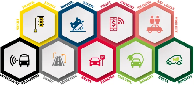
As shown in “Fig. 1” there are more areas of interest within Smart Mobility. According to Smart Mobility World [11], these are the main areas:
• Driving Safety – provide technology for safe and secure mobility, allowing cars to interact with other vehicles and the infrastructure around them.
• Smart Lightning Systems – uses LEDs with connected controls to provide better lightning, cut energy consumption, reduce traffic congestion and improve traffic flow.
• Sharing and Urban Mobility – shared transport systems include car sharing, bicycle sharing, carpools, and vanpools. Besides that, multimodal systems can use different and optimally combined transport modes within the trip chain in a seamless way to approach greater sustainability in urban transport.
• Electric Mobility – provides a key to the sustainable redesign of mobility that is climate and environment-friendly, efficient and allows to save resources.
• Green Mobility – minimizes the environmental impact caused by the transportation sector without impacting the growth momentum.
• Smart Payment Systems – implemented to overcome the limitation of the conventional payment methods by revamping the payment method via parking meter and other technologies.
This paper will focus on drivers, with an emphasis on Intelligent Transportation Systems, Smart Parking Systems, and Smart Traffic Lights Systems. These areas will be explained throughout the paper.
Smart Mobility is a key concept to transform urban transport and change the way our cities move. Several initiatives have been developed around the world to provide more mobility for citizens. One of the main examples of this effort to improve cities mobility is Big IoT [12], which is a European Platforms Initiative project [13] to solve the interoperability gap by defining a generic, unified Web API for smart object platforms. This pilot project is implementing services and applications for Barcelona, Piedmont, and Berlin/Wolfsburg:
• In Barcelona, traffic-based detectors to measure speed, and count cars were used to implement a smart parking application and a green route planning. In addition, several inductive loop detectors, road-side magnetometers control-stations, Bluetooth/Wi-Fi antennas, street parking sensors, and air quality sensing devices on connected cars were used.
• In Wolfsburg, a city-wide WLAN network has been incorporated to track public buses, as well as bike sharing stations. Real-time crowd management has been implemented using security cameras, and crowd-sourced detection of human crowds was tested through mobile apps. In Berlin, real-time data, such as real-time city-wide information on traffic volumes and traffic speed were
integrated with parking, bike sharing and charging stations data, and public transport information.
• In Piedmont, current traffic and environmental conditions are being tracked, by monitoring road traffic, by automatically counting vehicles through webcams, by the detection of presence/absence of vehicles on road parking spots, by environmental pollution monitoring through low-cost air quality stations, and by monitoring bike sharing stations. They’re developing various services and applications for bike navigation, live traffic monitoring, and route planning that takes into account the current air pollution.
Other technologies and approaches have been developed to solve the challenges of urban mobility:
Hernafi et al. [14] propose a communication model to alert other vehicles on the road, to prevent accidents and to improve security aspects in Smart Mobility. The simulation of the impact of driver’s behavior in the city was made within the SUMO (Simulation of Urban Mobility) [15], a traffic simulator to model the vehicle’s mobility. The main objective was to detect dangerous behavior on road, to alert other vehicles by disseminating warning messages in real time, and to investigate the impact of human behavior on Intelligent Transportation Systems.
Anagnostopoulos et al. [16] propose a cost-effective infrastructure to enable cyclist-aware traffic lights system. This system consists of an Android software running on cyclists’ smartphones, and a server that receives requests from those smartphones. The data reported are the cyclist’s mobile phone location, direction, and speed that is obtained via GPS. Each smartphone has a built-in list of traffic lights’ coordinates within the city, and the smartphone software’s objective is to predict whether the cyclist will attempt to cross a traffic light. The system computes the average speed based on the current speed recording and the previous speed-readings and sends a request for “green light” to the server. The server must manage multiple competing requests for green lights from cyclists, pedestrians pressing the physical green light request button at the intersection, and vehicular traffic sensed using underground magnetic sensors on the driveway.
Schulte et al. [17] suggest a service framework for Smart Mobility, the SIMPLI-CITY framework, developed for mobile devices running the Android operating system. It implements three main functionalities: the main context-based service, pushing of information from services to the end user, and data prefetching mechanisms. This framework uses road user information, specifically kinematics and location data retrieved from smartphones acting as an intermediary between the car and the Internet, or directly by the communication between the car and the Internet. It allows the creation of mobility-related services and to easily use the information provided to interact with the users in a non-distracting way since it is based on a speech recognition approach. It aims to exploit mobility-related data sources like traffic information including traffic accidents,
data from infrastructure sensors, personal calendar data, map and route data, and weather information.
Campolo et al. [18] designed the SMaRTCaR, (Supporting the MAnagement of Road Traffic through Car dAta Retrieval) framework. It allows citizens to take part in the collection and upload of traffic and environment-related data, using the technological features of modern cars, wireless devices, and crowdsourcing. Kinematic and environmental conditions data are transmitted to remote servers devoted to management and road congestion detection and prediction. SMaRTCaR is interconnected with the vehicle communication bus and uses dedicated hardware to retrieve data from external sensors. Its software core is based on a mobile application specifically developed for Android-based smartphones. The two main building blocks of the platform are:
• An Arduino board which receives inputs from a variety of sensors. Its main role is to collect data and perform data preprocessing. The Arduino platform was configured to offer a variety of wired and wireless communication interfaces.
• A smartphone that is used for data visualization and transmission. The smartphone application retrieves data from the Arduino board and shows it to the users, then it packs and remotely transmits data to the servers.
We can continue to build car-driven cities that lock in unsustainable standards, or we can scale up existing models to create more inclusive, accessible and connected cities. Going after Smarter Mobility options can help cities to adopt strategies that drive inclusive economic growth and quality of life. Nowadays, for the public, the most visible aspect of Smart Mobility is that almost everything can be done on the smartphones. The smartphones allow us to have information on traffic status to our destinations or available transportations at any time of the day, allowing the visualization and the collection of valuable data.
A. Intelligent Transportation Systems
It would not be possible to talk about Smart Mobility and Intelligent Transportation Systems, without talking about the networks that allow data to be collected and sent. One of the core component related to Intelligent Transportation Systems is the Vehicular Ad-hoc Network (VANET). It is an emerged application of Mobile Ad hoc Network (MANET). The main features of VANETs are high mobility, high computational ability, rapid changes in network topology, and variable network density. This is a kind of network in which vehicles act as computer nodes connected to a network through inter-vehicle communication channels. In the vehicular networks, the vehicles are equipped with wireless communication devices, allowing them to communicate with each other and with the road-side units. These communications allow vehicles to share contextual driving information, including safety information (e.g., dangerous driving situation) to prevent accidents or non-safety-related information (e.g., weather conditions, tourism, and traffic information).
Over the past few years, several research papers have focused on proposing communication protocols for VANETs [19]. Thus, several wireless solutions have been developed for vehicle-to-sensor, vehicle-to-vehicle, vehicle-to-Internet and vehicle-to-road [20]. In these networks, real-time traffic monitoring, traffic sign warnings, passenger recognition, barriers and road lanes, accident detection, and speed and distance estimation provide drivers with better decision-making capabilities. With VANETs, context-aware applications increase the "horizon of awareness" of the vehicle or the driver, allowing them to adapt various decisions per situation and enables them to sense, reason and react to the surrounding environment.
Two types of communications are used to allow nearby vehicles to communicate:
• Vehicle-to-Vehicle (V2V) – is an automobile technology designed to allow cars to “talk” to each other, by allowing wireless transmissions of data between vehicles. The goal of this technology is to prevent accidents by allowing vehicles in transit to send position, speed, and other data to one another over a Vehicular Ad hoc Network.
• Vehicles-to-Infrastructure (V2I) – is a series of technologies that directly links road vehicles to their physical surroundings, first and foremost to improve road safety. That is, technology, like sensors and microcontrollers, that allows cars to communicate with infrastructure elements.
These forms of communication offer a whole range of safety services and applications to improve road safety, traffic efficiency and provide a greener environment. In VANETs, all the information that describes the driving situation is called driving context information, and it can be the position, direction, speed and acceleration of the vehicle, traffic and weather information, among others. Driving context information changes dynamically, so Smart Mobility applications will need to be able to adapt their operations as a response to the change of driving context information and road condition.
As cities progress, one of the main aspects is the need for smarter and more efficient transportation mobility. Being considered as a part of the Smart Mobility, Intelligent Transportation Systems are the application of advanced technology to address transportation problems. They add considerable productivity to existing transportation infrastructure and reduce the need for more physical infrastructure such as additional lanes on the roadway. The Intelligent Transportation Systems field appeared in the 1980s when a small group of transportation professionals recognized the impact that Information and Communications Technology could have on transportation [21]. In recent years, the advances of IoT have promoted the development of Intelligent Transportation Systems. Specifically, by the aid of the advanced sensing, vehicular communication, and computing technologies, an individual vehicle can quickly detect traffic
anomalies and then notify neighboring vehicles. A series of papers have been published focusing on the IoT utilization for Intelligent Transportation Systems.
Liu et al. [22] propose an infrastructure-assisted message dissemination framework that uses the capability of infrastructures and supports heterogeneous driving patterns. For the simulated system, each vehicle was equipped with a communication module which integrated IEEE 802.11p/ITS-5G protocols and a GPS receiver, as well as onboard sensors to detect the vehicle’s kinetic status. Along the road, there were roadside sensors deployed to guarantee timely collecting local traffic information and report to the road-side units.
Michau et al. [23] use Bluetooth sensors to gather traffic and vehicular information, by using spatially constrained shortest path analysis in order to reconstruct the trajectories of the vehicles. The simulation was developed with AIMSUN [24], an agent-based traffic simulation software and then compared with the GPS tracks of a taxi company.
Daniel et al. [25] use Cognitive Radio in the cooperative vehicular environment to control collisions, avoid congestion, identify vehicles location and to restrict speed. To exhibit cooperative vehicular networks, hardware modules were designed for the vehicle-to-vehicle, the vehicle-to-infrastructure and infrastructure-to-infrastructure communications using Zigbee and Wi-Fi protocols. An Android application was developed to alert the users about the real-time traffic situation or if an accident occurs.
Bacon et al. [26] propose an open platform for capturing, processing and delivering transport-related data. TIME (Transport Information Monitoring Environment) explores how technology can help to reduce transportation’s economic and environmental impact by using a sensor network infrastructure that could detect traffic information. They investigate two distinct approaches to collect and disseminate traffic information: using special-purpose stationary sensor nodes (inductive loops, laser or infrared sensors) that collect and disseminate traffic information and using mobile sensor nodes, e.g. vehicles equipped with GPS and wireless transceivers, that opportunistically collect information as they are roaming through the city.
Nadeem et al. [27] suggest an Intelligent Transportation System to support safe driving, dynamic route scheduling, emergency message dissemination, and traffic condition monitoring. TrafficView is an application that collects and displays traffic information by means of vehicle-to-vehicle communication to exchange both immediate and distant traffic-related information for real-time safety warning, route planning, and traffic congestion mitigation.
Other Intelligent Transportation Systems are being developed in Europe [28], the United States [29], Asia [30], etc. which demonstrates that this is an area of great importance to the governments and municipalities of the cities.
B. Smart Parking Systems
Smart Parking systems are designed to be implemented in parking spaces and to detect the arrival and departure of vehicles. By providing accurate information on available parking spaces, drivers could save time and fuel, and cities could reduce atmospheric pollution and congestion. Smart Parking systems will help to transform parking management by offering a complete solution to mobility restrictions. Hafezi et al. [31] divide the Smart Parking Systems into five major categories:
• Parking Guidance and Information System (PGIS) – provides dynamic information on parking within controlled areas. The systems include traffic monitoring, communication, processing and static/dynamic message sign technologies.
• Transit Based Information System – focuses on guiding the user to park-and-ride facilities. It provides real-time information on the status of each car park and public transport such as the schedules and traffic condition to the public. These systems allow users to interact with information about traffic routes, schedules, and trip itinerary planning.
• E-parking – provides an alternative for costumers to enquire the availability and/or reserve a parking space at their desired parking facility to ensure the availability of vacant car parking space when they arrive at the parking facility. The system can be accessed through various methods such as SMS or over the Internet.
• Automated Parking – involves the use of the computer controlled mechanism, which automatically places the vehicle in an allocated space. These systems are designed to minimize the area and/or volume required for parking cars.
A diverse set of technologies is being used to solve the chronic parking and congestion challenges plaguing cities around the world. While the deployment of sensor technologies remains the core for the development of smart parking systems, many other technological innovations are also enabling more adaptable systems. These systems include cameras, wireless communications such as GPS and Wi-Fi, data analytics, induction loops, smart parking meters, and advanced technologies. Several researchers have developed and prototyped Smart Parking systems based on different perspectives.
Trigona et al. [32] propose a system that is composed of a network of tri-axial magnetic sensors, located on the pavement in order to detect vehicles. Cars are detected by measuring the change in the earth’s magnetic field caused by the presence of a vehicle near the sensor. In presence of magnetic force lines, it is possible to see the difference of magnetic field when a vehicle approaches the sensor, the vehicle begins to pass through the sensor’s detection zone and when the vehicle is over the sensor.
Lee et al. [33] propose a Smart Parking system to detect and find the parked location of a vehicle using ultrasonic and magnetic sensors. The proposed system detects vehicles in indoor and outdoor parking fields by using wireless sensors and BLE (Bluetooth Low Energy).
Shaik et al. [34] implemented a cost-efficient Smart Parking system for multi-level parking facility using Wireless Sensor Networks (IR Sensor) and developed an Android based application. The system monitors the availability of idle parking slots and guides the vehicle to the nearest free slot.
Khana and Anand [35] propose a system that consists of an on-site deployment of an IoT module that is used to monitor and signalize the state of availability of each single parking space. Infrared, Passive Infrared (PIR) and Ultrasonic Sensors were used and wirelessly connected to a Raspberry Pi using an ESP8266 chip. A mobile application was also provided to allow end users to check the availability of parking on a real-time basis.
Pham et al. [36] propose a Smart Parking System based on the integration of UHF frequency, RFID and IEEE 802.15.4 Wireless Sensor Network technologies. This system can collect information about the state of occupancy of the car parks, and can direct drivers to the nearest vacant parking spot by using a software application.
Nawaz et al. [37] developed two smartphone-based prototypes to enhance the driver experience:
• ParkSystem – a smartphone-based system that can sense on-street parking space occupancy when used together with electronic parking payment systems. It can collect real-time information relying only on the driver's smartphone Wi-Fi interface. It captures nearby Wi-Fi access points when users are paying and later detects if that user returned to the parked car location by periodically comparing observed access-point Service Set Identifiers with those captured during the payment process.
• The second system uses low-energy microelectromechanical systems (MEMS), accelerometers and gyroscopes embedded in smartphones to sense and recognize routes that the user frequently drives and to provide personalized alerts to the user. The system uses the smartphone’s accelerometer to sense the direction of gravity and the gyroscope to measure angular velocity around an axis parallel to gravity.
As the Smart Cities are becoming more and more popular, and the development of new solutions are improving the way citizens move around the city, the smart parking industry will continue to evolve as an answer to the increasing number of cities struggling with traffic congestion and inadequate parking availability.
C. Smart Traffic Lights
Smart Traffic Lights is a vehicle traffic control system that combines traditional traffic lights with a variety of sensors and artificial intelligence to intelligently route vehicle and pedestrian traffic. Traditional traffic lights control system works on a fixed-time basis, which cannot optimize the time of traffic lights per the change in traffic flow. It is a key problem in modern urban areas and has a severe impact on the management of traffic flow, energy consumption, and vehicular emissions, as well as on urban noise. Many traffic lights in modern cities increase the complexity of the scheduling problem and at the same time urges for an efficient solution that can optimize light cycle programs.
Various solutions are being developed to optimize traffic light cycles and to better serve the interests of citizens.
Ghazal et al. [38] propose a system based on Programmable Intelligent Controller microcontroller that evaluates the traffic density using IR sensors and XBee transceivers. Based on this information, the time dedicated to the green light will be extended to allow a large flow of cars in case of traffic jam, or reduced to prevent unnecessary waiting time when no cars are present at the opposite route. The system is complemented by a portable controller for the emergency vehicles stuck in the traffic.
Jagadeesh et al. [39] developed a project to enable the traffic lights to switch from red to green based on traffic density. The system consists of IR sensors, embedded low-power controllers (Arduino ATMEGA128), radio communication modules, and a storage device. It works based on the collection, processing, integration, and dissemination of information based on static and real-time data obtained from the sensors on the roads. The time for vehicle passing during the green light would be dynamically adjusted through the sensors and microcontroller based on the current density of vehicles.
Moller et al. [40] propose a system that uses sensors, actuators, and communication technologies to calculate the arrival time of vehicles at a traffic light by monitoring the actual speed of the vehicles. This system uses a peer-to-peer communication network capable of alerting drivers and onboard computers about what is happening on the traffic lights.
In the largest cities in the world, being able to control traffic signals in an automatic and intelligent way, would not only improve the lives of drivers but also of pedestrians and cyclists.
III. CONCLUSION
As discussed in this paper, many solutions exist in terms of systems, middleware, applications, techniques, and models proposed by researchers to solve different challenges in the Smart Mobility field. The papers and solutions provided clearly show the importance of Smart Mobility in the Internet of
Things Paradigm, and the effort of the researchers to find solutions to make our cities more livable and comfortable.
Orchestrating the Smart City ecosystem is a combination of technology and imagination that blends problems related to many different fields. Currently, there are many Smart City deployments based on custom systems and solutions, but that are not interoperable, portable across cities, extensible, or cost-effective. A large city can be thought of as a complex organism whose parts do not work perfectly in sync and do not add up to a unified whole. Each solution seems to solve a problem of a particular city, being inadequate for other cities in the world. Three barriers can be identified when talking about Smart Cities:
• They generate uneven geographic development creating winners and losers. They further marginalize farmers, micro-entrepreneurs and indigenous people living in villages, small towns, rural areas and poor urban neighborhoods, whose interests are not protected by Smart City policies increasing the gap between urban and rural areas.
• Privacy is another major concern with Smart City technologies, many of which can capture personally identifiable information and household-level data about citizens. It must play an instrumental role in any Smart City strategy, otherwise, citizens might fear the introduction of this innovative technology.
• A lack of collaboration, attributed to the siloed nature of governments, is another barrier to Smart Cities. With different departments not sharing information and knowledge both internally and across councils to prevent multiple similar initiatives and essentially reinventing the wheel, not saving money as well as time, and not working together in the most efficient way.
Smart Mobility also has the same problems, but as the mobility sector features unique opportunities for business development, several consortia (governments, interest groups, companies, and research institutes) have built prototypes and solutions for the mobility problems inside the cities. A good example is that car manufacturers are producing vehicles with complex new connectivity-dependent features like driver assistance and collision avoidance, or even self-driving cars that can sense their environment and navigate without any human input.
The larger gaps found inside the Smart Mobility field was about VANETs and Smart Traffic Lights. There are several routing protocols in VANETs that could be promising technologies for Intelligent Transportation Systems. But none of them is a definitive solution, and there is space for more investigation and better development. In Smart Traffic Lights systems, the problem is that many cities are using adaptive signal timing on at least some traffic lights, but they’re not always making the most of their data. Some examples of gaps found about the systems implemented are: these systems don’t always provide mechanisms for the occurrence of an
emergency vehicle to give it priority over other vehicles and don’t give traffic information to the users. Another problem detected was that the rollout of Smart Traffic Lights has been slow, with some complaints about the lights being too unpredictable. But, with the advances in automotive, communications, and sensor technologies we can only expect a golden era for IoT and Smart Cities. With the advances in automotive, communications, and sensor technologies we can only expect a golden era for Internet of Things and Smart Cities.
IV. FUTURE WORK
A solution inside Smart Mobility is being developed, aiming to improve the quality of life in cities, with a focus on improving mobility and reducing daily stress by providing a service for a more efficient time management. This solution will collect information about extraordinary events that take place in the cities (road blocks, sport events, celebrations …) integrating information about these events, like interrupted roads and changes in the direction of traffic, that is currently spread across several websites where this information is usually published (municipality and government websites). This solution will also include a set of mobile and stationary sensors. Mobile sensors will include sensors that are embedded on smartphones or on other wearables, those already available in most vehicles, and additional sensors that might be installed in vehicles (like buses, municipality vehicles …).
REFERENCES
[1] M. Weiser, “The Computer for the 21st Century,” Sci. Am., vol. 265, no. 3, pp. 94–104, 1991.
[2] K. Ashton, “That ‘Internet of Things’ Thing,” RFiD J., vol. 22, no. 7, pp. 97–114, 2009.
[3] T. Nam and T. A. Pardo, “Conceptualizing smart city with dimensions of technology, people, and institutions,” in Proceedings of the 12th annual international digital government research conference: digital government innovation in challenging times, 2011, pp. 282–291. [4] “About - IEEE Smart Cities.” [Online]. Available:
http://smartcities.ieee.org/about.html. [Accessed: 23-Feb-2017].
[5] R. Giffinger and H. Gudrun, “Smart cities ranking: an effective instrument for the positioning of the cities?,” ACE Archit. City Environ., vol. 4, no. 12, pp. 7–26, Feb. 2010.
[6] B. Bowerman, J. Braverman, J. Taylor, H. Todosow, and U. Von Wimmersperg, “The vision of a smart city,” in 2nd International Life Extension Technology Workshop, Paris, 2000, vol. 28.
[7] C. Harrison et al., “Foundations for Smarter Cities,” IBM J. Res. Dev., vol. 54, no. 4, pp. 1–16, Jul. 2010.
[8] V. Albino, U. Berardi, and R. M. Dangelico, “Smart Cities: Definitions, Dimensions, Performance, and Initiatives,” J. Urban Technol., vol. 22, no. 1, pp. 3–21, Jan. 2015. [9] B.-T. Chun and S.-H. Lee, “Review on ITS in Smart City,”
[10] A. Vanolo, “Smartmentality: The Smart City as Disciplinary Strategy,” Urban Stud., vol. 51, no. 5, pp. 883–898, Apr. 2014.
[11] “SmartMobilityWorld | Smart Mobility, Smart People, Smart City.” .
[12] “BIG IoT – Bridging the Interoperability Gap of the Internet of Things.” .
[13] “BIG IoT,” IoT-EPI. .
[14] Y. Hernafi, M. B. Ahmed, and M. Bouhorma, “An approaches’ based on intelligent transportation systems to dissect driver behavior and smart mobility in smart city,” in 2016 4th IEEE International Colloquium on Information Science and Technology (CiSt), 2016, pp. 886–895. [15] “DLR - Institute of Transportation Systems - SUMO –
Simulation of Urban MObility.” [Online]. Available:
http://www.dlr.de/ts/en/desktopdefault.aspx/tabid-9883/16931_read-41000/. [Accessed: 01-Mar-2017]. [16] T. Anagnostopoulos, D. Ferreira, A. Samodelkin, M.
Ahmed, and V. Kostakos, “Cyclist-aware traffic lights through distributed smartphone sensing,” Pervasive Mob. Comput., vol. 31, pp. 22–36, Sep. 2016.
[17] S. Schulte, P. Hoenisch, K. Kipp, D. Burgstahler, S. Abels, and G. Liguori, “A Service Framework for Smart Mobility Scenarios,” in 2016 IEEE International Conference on Mobile Services (MS), 2016, pp. 17–24.
[18] C. Campolo, A. Iera, A. Molinaro, S. Y. Paratore, and G. Ruggeri, “SMaRTCaR: An integrated smartphone-based platform to support traffic management applications,” in 2012 First International Workshop on Vehicular Traffic Management for Smart Cities (VTM), 2012, pp. 1–6. [19] F. Bai and B. Krishnamachari, “Exploiting the wisdom of
the crowd: localized, distributed information-centric VANETs [Topics in Automotive Networking],” IEEE Commun. Mag., vol. 48, no. 5, pp. 138–146, May 2010. [20] H. Vahdat-Nejad, A. Ramazani, T. Mohammadi, and W.
Mansoor, “A survey on context-aware vehicular network applications,” Veh. Commun., vol. 3, pp. 43–57, Jan. 2016. [21] R. J. WEILAND and L. B. PURSER, “YOU’VE COME A
LONG WAY, ITS.”
[22] B. Liu et al., “Infrastructure-Assisted Message Dissemination for Supporting Heterogeneous Driving Patterns,” IEEE Trans. Intell. Transp. Syst., vol. PP, no. 99, pp. 1–12, 2017.
[23] G. Michau, A. Nantes, A. Bhaskar, E. Chung, P. Abry, and P. Borgnat, “Bluetooth Data in an Urban Context: Retrieving Vehicle Trajectories,” IEEE Trans. Intell. Transp. Syst., vol. PP, no. 99, pp. 1–10, 2017.
[24] “TSS-Transport Simulation Systems –,” TSS-Transport
Simulation Systems. [Online]. Available:
https://www.aimsun.com. [Accessed: 01-Mar-2017]. [25] A. Daniel, A. Paul, A. Ahmad, and S. Rho, “Cooperative
Intelligence of Vehicles for Intelligent Transportation Systems (ITS),” Wirel. Pers. Commun., vol. 87, no. 2, pp. 461–484, Mar. 2016.
[26] J. Bacon et al., “TIME: An Open Platform for Capturing, Processing and Delivering Transport-Related Data,” in
2008 5th IEEE Consumer Communications and
Networking Conference, 2008, pp. 687–691.
[27] T. Nadeem, S. Dashtinezhad, C. Liao, and L. Iftode, “TrafficView: traffic data dissemination using car-to-car communication,” ACM SIGMOBILE Mob. Comput. Commun. Rev., vol. 8, no. 3, pp. 6–19, 2004.
[28] “Intelligent transport systems - Mobility and Transport - European Commission,” Mobility and Transport. [Online]. Available: /transport/themes/its_en. [Accessed: 01-Mar-2017].
[29] “Intelligent Transportation Systems - Joint Program Office Home Page.” [Online]. Available: http://www.its.dot.gov/. [Accessed: 01-Mar-2017].
[30] “ITS asia-pacific.” [Online]. Available: http://itsasia-pacific.com/. [Accessed: 01-Mar-2017].
[31] M. H. Hafezi, A. Ismail, and A. A. Shariff, “Comparative Analysis of Fare Collection System on Bus Operations,” J. Appl. Sci., vol. 12, no. 4, pp. 393–397, Apr. 2012.
[32] C. Trigona et al., “Implementation and characterization of a smart parking system based on 3-axis magnetic sensors,”
in 2016 IEEE International Instrumentation and
Measurement Technology Conference Proceedings, 2016, pp. 1–6.
[33] C. Lee, Y. Han, S. Jeon, D. Seo, and I. Jung, “Smart parking system for Internet of Things,” in 2016 IEEE International Conference on Consumer Electronics (ICCE), 2016, pp. 263–264.
[34] F. I. Shaikh, P. N. Jadhav, S. P. Bandarkar, O. P. Kulkarni, and N. B. Shardoor, “Smart Parking System Based on Embedded System and Sensor Network,” Int. J. Comput. Appl., vol. 140, no. 12, 2016.
[35] A. Khanna and R. Anand, “IoT based smart parking system,” in 2016 International Conference on Internet of Things and Applications (IOTA), 2016, pp. 266–270. [36] T. N. Pham, M. F. Tsai, D. B. Nguyen, C. R. Dow, and D.
J. Deng, “A Cloud-Based Smart-Parking System Based on Internet-of-Things Technologies,” IEEE Access, vol. 3, pp. 1581–1591, 2015.
[37] S. Nawaz, C. Efstratiou, and C. Mascolo, “Smart Sensing Systems for the Daily Drive,” IEEE Pervasive Comput., vol. 15, no. 1, pp. 39–43, Jan. 2016.
[38] B. Ghazal, K. ElKhatib, K. Chahine, and M. Kherfan, “Smart traffic light control system,” in 2016 Third International Conference on Electrical, Electronics, Computer Engineering and their Applications (EECEA), 2016, pp. 140–145.
[39] Y. M. Jagadeesh, G. M. Suba, S. Karthik, and K. Yokesh, “Smart autonomous traffic light switching by traffic density measurement through sensors,” in 2015 International Conference on Computers, Communications, and Systems (ICCCS), 2015, pp. 123–126.
[40] D. P. F. Möller, A. X. Fidencio, E. Cota, I. A. Jehle, and H. Vakilzadian, “Cyber-physical smart traffic light system,”
in 2015 IEEE International Conference on