www.scielo.br/aabc
Shallow gas accumulation in sediments of the Patos Lagoon,
Southern Brazil
JAIR WESCHENFELDER1, IRAN C.S. CORRÊA1, SALVADOR ALIOTTA2, CARLA M. PEREIRA1 and VINICIUS E.B. DE VASCONCELLOS1
1Instituto de Geociências, Universidade Federal do Rio Grande do Sul
Cx. Postal 15.001, 91501-970 Porto Alegre, RS, Brasil
2Instituto Argentino de Oceanografia Complejo CRIBABB
Camino Carindanga km 7, 8000 Bahia Blanca, Argentina
Manuscript received on March 31, 2005; accepted for publication on March 10, 2006;
presented byLAUROV.S. NARDI
ABSTRACT
A high resolution seismic survey was conducted in the Patos Lagoon, southern Brazil, aboard of the research vessel LARUSof the Fundação Universidade Federal do Rio Grande (FURG). Around 400 km of 3.5 kHz seismic profiles were collected, which provided acoustic signals of good penetration depth and resolution. Seismic anomalies, including turbidity and pocket gas, revealed that gas-charged sediments are common in several areas of the lagoon. The gas accumulations in the Patos Lagoon are controlled by the spatial distribu-tion of the sedimentary facies. Either in ‘curtains’ or in ‘acoustic turbid zones’, the main gas accumuladistribu-tions occur in areas with paleotopographic lows related to fluvial channels and valleys developed in the Rio Grande do Sul coastal plain during regressive/transgressive events of the Quaternary.
Key words:shallow gas, 3.5 kHz seismic, coastal plain, Rio Grande do Sul.
INTRODUCTION
Seismic survey undertaken in the last decades has helped detecting gas concentration in recent depo-sits located in several coastal environments around the world (Garcia-Garcia et al. 1999, Karisiddaiah et al. 1992, Papatheodorou et al. 1993, Park et al. 1991). For the particular case of the South America Atlantic coast, gas occurrences have been reported in the Rio de La Plata estuary (Parker and Pater-lini 1990), in the inner section of the San Matias Gulf (Aliotta et al. 2000) and in the Bahía Blan-ca estuary (Aliotta et al. 2002). In Brazil, gas in sediments has been detected in the Guanabara Bay in the State of Rio de Janeiro (Baptista Neto et
Correspondence to: Prof. Jair Weschenfelder E-mail: jair.weschenfelder@ufrgs.br
al. 1996, Quaresma et al. 2000), and in shallow parts of the Amazonas Continental Shelf (Costa and Figueiredo 1998, Figueiredo et al. 1996).
Shallow seismic survey undertaken in Qua-ternary sediments from the Patos Lagoon revealed acoustic anomalies that were related to gas occur-rences. The purpose of this study is to characterize these anomalies, providing new elements to under-stand the mode of gas formation within the context of geological evolution of this coastal plain.
STUDY AREA
608 JAIR WESCHENFELDER et al.
sedimentary basins situated along the Brazilian continental margin. The evolution of these basins is related to crustal rupture of the Western Gond-wana landmass and subsequent formation of the South Atlantic Ocean. Seismic data of the upper slope of the Pelotas Basin indicate a sedimentary package more than 10 km thick, consisting mostly of shales, sandstones, carbonates and conglomer-ates, deposited from Late Mesozoic to Recent.
The coastal zone of RS is characterized by wide lowlands throughout an area of around 33,000 km2, bounded by highlands to the west
and the Atlantic Ocean to the east. It is one of the widest coastal plains of the world.
The Patos Lagoon, with its approximately 10,000 km2, is a remarkable feature in the
phy-siography of the coastal plain of RS. The lagoon, 240 km long (NE-SW) and averaging 40 km wide, receives an enormous river discharge from a huge drainage area and leads it to the Atlantic Ocean through a single inlet – the Rio Grande Channel – located near the city of Rio Grande, at the south-ernmost part of the lagoon. Sandy spits represent a remarkable feature that extends several kilome-ters from the margin into the center areas of the lagoon. On the west side of the lagoon, the sub-merged part of these spits extends up to 15 km (Toldo et al. 2000).
Studies on sedimentation, wave pattern and dynamics in the Patos Lagoon were presented by Toldo-Jr (E.E. Toldo-Jr., unpublished data) and Toldo-Jr et al. (2000). According to these two works, the lagoon is a large and shallow (average depth of 6 m) coastal water body, not much influ-enced by the astronomic tides (<45 cm), and pro-tected from an environment dominated by waves of the nearby ocean. Moreover, Toldo-Jr et al. (2000), based on several morphological and sedimentolog-ical criteria, established two distinct areas in the Patos Lagoon: 1) a sandy margin, and 2) a flat and muddy center. Depths ranging between 5 and 6 m separate both areas. The muddy area represents ap-proximately up to 40% of the lagoon. The bottom and margins of the lagoon are subject to the
influence of waves, which may reach up to 1.6 m high.
Upper Quaternary sea level changes were the main process responsible for sediment evolution in the Patos Lagoon. The deposits, which alternate ba-sically coastal-barrier sands and lagoonal silts and clays, have been related to four phases of a lagoon-barrier depositional system (Villwock et al. 1986). The sandy packages may form aquifers and/or gas reservoirs, while the finer, mainly muddy sediments may form aquitards and/or sealing layers.
METHODOLOGY OF SEISMIC DATA ACQUISITION
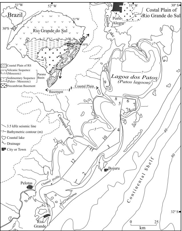
Approximately 400 km of high-resolution seismic profiles were recorded inside the Patos Lagoon (Fig. 1), a task performed aboard of the LARUS, the research vessel of the Fundação Universidade Federal do Rio Grande (FURG). The position of ship routes and seismic profiles was determined by a differential global position system (DGPS).
The seismic data were obtained with a Geo-Acoustics subbottom profiler system, operating at
3.5 kHz frequency, and consisting of a Geopulse
5430A transmitter, a Geopulse 5210A receiver, a Geopulse 132B 4-mount transducer array, an EPC
GSP 1086 graphic recorder, a GeoPro processor
system, and a Sonarwiz seismic data acquisition
software. The transducer was mounted on the outer side of the hull of the LARUS and it served simul-taneously as sender and receiver of the acoustic signal. The seismic dataset was saved in analog-ical and SEG-Y digital formats. The profiles are presented with depths to water surface in two-way traveltime, in milliseconds (ms). An average esti-mated acoustic velocity of 1650 m/s was used to calculate the thickness of the sedimentary packages.
RESULTS
610 JAIR WESCHENFELDER et al.
sediments, there may be some gradation between these two types or even a gradual or sudden change to sections apparentlywithout gas.
Gas curtain– this type of gas accumulation
usu-ally shows a well defined morphology, in the form of ‘boxes’ of anomalous seismic reflection with an upper surface well marked by strong, relatively con-tinuous, horizontal or gently dipping top reflectors. The acoustic response below the top reflectors is usually chaotic, masking the underlying sedimen-tary structures. Gas curtains range from a few me-ters to several kilomeme-ters laterally (Fig. 2a). Side-wards, the strong top reflector is sometimes sud-denly interrupted, forming ‘acoustic windows’ (Fig. 2b). When several acoustic windows are present in the seismic records the lateral continuity of the seismic reflectors can be established, as well as the internal structure of the sedimentary units. The gas curtains are usually interspersed with acoustic win-dows. Like gas curtains, acoustic windows range from just a few meters to several kilometers wide.
Acoustic turbid zone – this is a type of gas
ac-cumulation in which the acoustic anomaly is char-acterized by a more irregular and less marked top reflector than zones with gas curtains. The seismic reflectors underlying the top of the gas accumulation are not entirely hidden, allowing the identification and mapping of the sedimentary structures (Fig. 2c and d).
Similarly to gas curtains, acoustic turbid zones can also range from a few meters to several kilo-meters laterally. The upper surfaces of these gas accumulations are diffuse, sometimes reaching the bottom of the lagoon (Fig. 2c). The gradual tran-sition from acoustic turbid zones to gas curtains or to zones without gas was observed in some seismic sections.
DISTRIBUTION OFSHALLOWGAS IN THE PATOSLAGOON
Acoustic gas anomalies have been identified in all seismic sections of the Patos Lagoon, being more frequent in inner areas of the lagoon (e.g., profiles
3, 5, 10 and 12) than marginwards (e.g., profiles 1,
2, 6 and 7) (Fig. 1).
Gas curtains occur mainly in the central part of the lagoon, usually where the configuration of the seismic reflectors indicates paleotopographic depressions. For instance, the two big gas accumu-lations seen in profile 12 occur within depression separated by paleotopographic highs delineated by strong seismic reflectors (Fig. 3). In this section, the northeastermost gas curtain, which occurs in front of the present mouth of the Camaquã River, is well-defined by a big (∼7 km wide), continu-ous ‘gas box’ displaying a upper surface marked by a strong reflector (Fig. 3, left side). However, the southwestermost gas curtain shows a top mark-ed by a diffuse reflector. In addition, this gas cur-tain grades laterally to an acoustic turbid zone and, southwestwards, to a zone with minor quantities of gas or even gas free (Fig. 3, right side).
Acoustic turbid zones occur in several of the mapped seismic profiles. It is a gas accumulation usual at the border of pocket gas, at marginal sec-tions of the lagoon and in sedimentary packages elsewhere.
DISCUSSION
High-frequency seismic profiles mapped inside the Patos Lagoon show anomalous acoustic configura-tions commonly attributed as typical for sediments loaded with gas (Judd and Hovland 1992, Hart and Hamilton 1993, Figueiredo et al. 1996).
The presence of gas in sediments is detected especially by high-resolution seismic profiling due to the change of speed of the acoustic wave be-tween mediums with and without gas. The higher the speed gradient between the mediums, the stron-ger the echo response generated by the variation of acoustic impedance between them. The intensity of the reflected acoustic signal recorded in the seismic profiles can be related to the concentration of gas bubbles in the sediments (Aliotta et al. 2002).
Fig. 2 – Acoustic anomalies from seismic line 4 (see Fig. 1 for location): a) intercalation of ‘gas curtains’ with ‘acoustic windows’; b) zoom of the dashed part of figure 2a; c) record with ‘acoustic blanking’ and gas at the lagoon bottom; d) detail of an ‘acoustic turbid zone’ showing sedimentary stratification. Depths to water surface in two-way traveltime, in milliseconds (ms).
Fig. 3 – Linkage of gas occurrences to areas of paleotopographic lows in profile 12 (see Fig. 1 for location). Depths to water surface in two-way traveltime, in milliseconds (ms).
the sedimentary package. Hence, ‘acoustic turbid-ity’ zones occur where the presence of gas causes a strong reflection at the top of the gassy package, usually masking deeper reflectors. This
612 JAIR WESCHENFELDER et al.
gas causes the phenomenon known as ’gas bright-ening’ (Hart and Hamilton 1993). ‘Acoustic blank-ing’ anomalies were observed in some segments of the seismic records (Fig. 2c). In this acoustic phe-nomenon, seismic reflections below the gas hori-zon are very weak or absent due the attenuation of the acoustic signal (Judd and Hovland 1992).
In the Patos Lagoon, the sections with gas curtains correspond to higher gas concentrations in relation to acoustic turbid zones. The morphology of ‘gas curtains’ is attributed to the presence of ‘pocket gas’ in the sedimentary package. As a re-sult, there is a strong reflection and then dispersion of the seismic wave, hiding possible reflectors underlying the strong top reflector of the gas cur-tains. However, in acoustic turbid zones, the gas concentrations are smaller, allowing a certain de-gree of penetration of the seismic energy. The seis-mic reflectors underlying the top of the package with less quantities of gas are only partially hid-den. Hence, mapping of sediment architectural pat-terns in the Patos Lagoon can be performed where acoustic turbid zones are present, as well as in the many and wide acoustic windows usually occurring interspersed with gas curtains and/or turbid zone morphologies.
Seismic mapping has led to the identification of palevalleys and paleochannels in the Patos La-goon (J. Weschenfelder, unpublished data). Close spatial association of gas occurrences and paleo-topographic lows caused by fluvial incision in the RS coastal plain was suggested by Weschenfelder et al. (2005a, b).
Sectors of the seismic records representing areas of paleotopographic depressions and areas of former deltaic environments are the places show-ing the most important gas accumulations. Some of these paleotopographic lows can be linked to for-mer river courses (e.g., the Camaquã River) that
dis-sected the costal plain of RS when sea level was much lower than today (Corrêa 1996). The sedi-mentary fill of these incised channels and valleys is related to sedimentary processes of subsequent transgressive events (Weschenfelder et al. 2005b).
The paleotopographic high delineated by the seismic reflectors in the middle of profile 12 has been interpreted as sedimentary in origin (J. Wes-chenfelder, unpublished data). It should be inter-preted as a paleospit, as it resembles the modern sandy spits that extend from the margin to the cen-ter of the lagoon.
Biogenic degradation of organic matter in se-diments is reported by Kaplan (1974) as a main source of gas in marine sediments. The gas accu-mulations mapped in the Patos Lagoon are shallow and occur in a dominantly fine-grained sedimentary package deposited during the Quaternary. This sug-gests that the gas concentrations might have orig-inated from the degradation of organic matter de-posited in the paleoenvironments developed there. Thus, the source of gas and the accumulation mode are intimately related to the sedimentary environ-ments and to the evolutionary processes responsi-ble for the formation of the vast coastal water body of the Patos Lagoon.
The acoustic windows in the seismic records of the Patos Lagoon occur due to an abrupt lateral discontinuity in some seismic horizons related to gas. They may suggest either an absence of orga-nic matter for generating gas or the lack of a trap-ping layer (Costa and Figueiredo 1998, Figueiredo et al. 1996).
Geological studies are currently been con-ducted in the Patos Lagoon in order to identify the degree of control exerted by the distribution of the sedimentary facies, permeability of the sedimen-tary layers and original amount of organic matter on gas accumulations. The present work contributes with these studies by characterizing the gas accu-mulation of this area.
CONCLUSIONS
acous-tic anomalies detected as anomalous seismic reflec-tions. Sectors with ‘gas curtains’ and ’acoustic tur-bid zones’ can be differentiated through such ano-malies. In some seismic sections, sectors of acous-tic anomalies intersperse with acousacous-tic windows, and represent packages with gas alternating with packages without gas, respectively.
Gas accumulations in the Patos Lagoon are controlled by the spatial distribution of the sedi-mentary facies. Either in ‘curtains’ or in ‘acous-tic turbid zones’, the gas occurs mainly in inner zones of the lagoon, almost always associated with areas displaying low paleotopography, related to paleodrainage systems. Such drainage systems, re-presented by fluvial channels and valleys, were probably formed during low sea level episodes. De-pressions caused by such fluvial incisions were drowned and filled up by sediments during a sub-sequent transgression.
The shallow gas in the Patos Lagoon substrate is intimately linked to sedimentary environments and to the evolution of the Rio Grande do Sul coas-tal system as result of Quaternary sea level fluctua-tion.
RESUMO
Um levantamento sísmico de alta resolução foi realizado na Lagoa dos Patos, sul do Brasil, a bordo da Lancha Oceanográfica Larus da Fundação Universidade Federal do Rio Grande (FURG). Foram levantados aproximada-mente 400 km de perfis de 3,5 kHz, os quais apresen-taram uma resposta acústica de boa penetração e reso-lução. Anomalias sísmicas, incluindo turbidez acústica e bolsões de gás, revelam que sedimentos carregados de gás são comuns em diversas áreas do corpo lagunar. As acumulações de gás na Lagoa dos Patos são controladas pela distribuição espacial das fácies sedimentares. Tanto as acumulações de gás na forma de ‘cortinas’, como as ‘zonas acusticamente turvas’, ocorrem em área de bai-xios paleotopográficos, vinculados a vales e canais flu-viais que se desenvolveram na planície costeira do Rio Grande do Sul durante os eventos regressivos/transgres-sivos do Quaternário.
Palavras-chave: gás raso, sísmica de 3,5 kHz, planície costeira, Rio Grande do Sul.
REFERENCES
ALIOTTA S, KOSTADINOFF J AND LIZASOAIN G. 2000. Sísmica somera com 3.5 kHz de la Platafor-ma Continental norpatagónica, Argentina. In: II CONGRESSO LATINOAMERICANO DE SEDIMEN -TOLOGÍA. Mar del Plata, Argentina. Resúmenes, p. 26–27.
ALIOTTAS, LIZASOAING ANDGINSBERGS. 2002. Hallazgo de acumulaciones de gas con sismica de alta resolucion en sedimentos del estuario de Bahia Blana, Argentina. In: CABALERINET AL. (Eds), Actas del XV Congresso Geológico Argentino (CD-ROM) 146: 315–318.
BAPTISTANETOJA, SILVAMAMANDFIGUEIREDO JRAG. 1996. Sísmica de alta freqüência e o padrão de distribuição de sedimentos na enseada de Juru-juba (Baía de Guanabara) – RJ/Brasil. Rev Bras Geof 14: 51–57.
CORRÊAICS. 1996. Les variations du niveau de la mer durant les derniers 17.500 ans BP. L’exemple da la plateforme continentale du Rio Grande do Sul – Bre-sil. Mar Geol 130: 163–178.
COSTAEAANDFIGUEIREDOAG. 1998. Echo-charac-ter and sedimentary processes on the Amazon Conti-nental Shelf. An Acad Bras Cienc 70: 187–200. FIGUEIREDOAG, NITTROUER CAANDCOSTAEA.
1996. Gas-charged sediments in the Amazon Sub-marine Delta. Geo-Marine Letters 16: 31–35. GARCIA-GARCIA A, VILAS F ANDGARCIA-GIL S.
1999. A seeping sea-floor in Ria environment: Ria de Vigo (Spain). Envir Geol 38: 296–300.
HART BS AND HAMILTON TS. 1993. High resolu-tion acoustic mapping of shallow gas in unconsoli-dated sediments beneath the Strait of Georgia, British Columbia. Geo-Marine Letters 13: 49–55.
JUDDAGANDHOVLAND M. 1992. The evidence of shallow gas in marine sediments. Cont Shelf Res 12: 1081–1096.
KAPLANIR. 1974. Introduction. In: KAPLANIR (Ed), Natural gases in Marine Sediments. Planum Press, New York, USA, p. 1–10.
614 JAIR WESCHENFELDER et al.
inner continental shelf off western India. Mar Geol 110: 143–152.
PAPATHEODOROUG, HASIOTISTANDFERENTINOS G. 1993. Gas-charged sediments in the Aegean and Ionian Seas, Greece. Mar Geol 112: 171–184. PARK SC, KIM YS ANDHONG SK. 1991. Shallow
seismic stratigraphy and distribution pattern of late Quaternary sediments in a macrotidal bay, Gunhung Bay, west coast of Korea. Mar Geol 98: 135–144. PARKERGANDPATERLINIM. 1990.
Apantallamien-tos acústicos en sedimenApantallamien-tos gasíferos del Rio de La Plata. Rev Asoc Geol Argent 45: 17–28.
QUARESMAVS, DIASGTMANDBAPTISTANETOJA. 2000. Caracterização da ocorrência de padrões de sonar de varredura lateral e sísmica de alta freqüên-cia (3,5 e 7,0 kHz) na porção sul da Baía de Guana-bara – RJ. Rev Bras Geof 18: 201–214.
TOLDOJREE, DILLENBURGSR, CORRÊAICSAND ALMEIDALESB. 2000. Holocene sedimentation in Lagoa dos Patos lagoon, Rio Grande do Sul, Brazil. J Coast Res 16: 816–822.
VILLWOCK JA, TOMAZELLI LJ, LOSS EL, DEHN -HARDT EA, HORN FILHO NO, BACHI FA AND DEHNHARDTBA. 1986. Geology of the Rio Grande do Sul Coastal Province. Quaternary of South Amer-ica and Antarctic Península 4: 79–97.
WESCHENFELDER J, CORRÊA ICS, AYUP-ZOUAIN RN, ALIOTTA A, PEREIRA CM AND VASCON -CELLOSVEB. 2005a. Gas accumulations revealed by high-resolution seismics in the Patos Lagoon, southern Brazil. In: VIII INTERNATIONALCON -FERENCE ONGAS INMARINESEDIMENTS. Vigo, Spain, 133 p.