VIRGINIA MYRIAN
FERNANDEZ RAMOS
ANÁLISE DO RISCO DE INCÊNDIO FLORESTAL
NA COSTA URUGUAIA ATLÂNTICA
ASSESSMENT OF FOREST FIRE RISK IN THE
ATLANTIC COAST OF URUGUAY
VIRGINIA MYRIAN
FERNANDEZ RAMOS
ANÁLISE DO RISCO DE INCÊNDIO FLORESTAL
NA COSTA URUGUAIA ATLÂNTICA
ASSESSMENT OF FOREST FIRE RISK IN THE
ATLANTIC COAST OF URUGUAY
Tese apresentada à Universidade de Aveiro para cumprimento dos requisitos necessários à obtenção do grau de Doutor em Ciências e Engenharia do Ambiente, realizada sob a orientação científica da Doutora Celeste Oliveira Alves Coelho, Professor of the Departmento do Ambiente e Ordenamento da Universidade de Aveiro e a co-orientação da Doutora. Claudia Natenzon, Professor Associado da Faculdad de Filosofia y Letras da Universidad de Buenos Aires.
Thesis presented to the Universidade de Aveiro for compliance with the requirements necessary to obtain the degree of Doutor em Ciências e Engenharia do Ambiente, conducted under the scientific guidance of Doutora Celeste Oliveira Alves Coelho, Professor of the Departmento do Ambiente e Ordenamento da Universidade de Aveiro and co-orientation of Dr. Claudia Natenzon, Associate Professor of the Facultad de Filosofía y Letras of the Universidad de Buenos Aires.
The jury
president Doutora Ana Maria Monteiro de Sousa
Professora catedrática da Universidade do Porto / Faculdade de Letras
Doutor José Carlos Ribeiro Ferreira
Professor auxiliar da Faculdade de Ciências e Tecnologia Universidade Nova de Lisboa/Departamento de Ciências e Engenharia do Ambiente
Doutor António José Dinis Ferreira
Professor Adjunto do Instituto Politecnico de Coimbra/ Escola Superior Agrária de Coimbra
Doutora Filomena Maria Cardoso Pedrosa Ferreira Martins Professora associada da Universidade de Aveiro
Doutora Celeste de Oliveira Alves Coelho (orientadora) Professora catedrática da Universidade de Aveiro
acknowledgment
I want to especially thank my tutor, Professor Celeste Coelho, for her guidance with exceptional patience, enthusiasm and generosity, always finding the inspiring right words to promote interest in my research. I am also very grateful to my co-tutor, Professor Claudia Natenzon, for her support and permanent willingness to help, strongly encouraging my academic growth. For both of them, my greatest recognition as researchers and deeply committed women with our society; I feel honoured with their friendship.
I also want to express my gratitude to all my colleagues from the Department of Geography who have offered their support and collaboration at all times. I particularly mention Virginia Pedemonte, Soledad Camacho, Raquel Alvarado, Yuri Resnichenko and Nicolás Frank for their trust, their contributions and the time they have dedicated to me by giving confidence to this initiative. I also thank my co-workers of the National Environment Direction; I highlight the advice of Rosina Seguí, the support of Marisol Mallo and the willingness and good spirits of Laura Olveira; all them have collaborated to make progress in my work.
I extend my gratitude to all those who from the University of Aveiro have given me their help in the tasks that the postgraduate involves; I want to mention Estela Pinto and Eugenia Taveira. I also say many thanks to Sandra Valente for sharing her workspace and academic material during my visits. Really important for me is to make a special mention to the invaluable and permanent help of Filomena Martins that helped me to overcome the barriers of distance and always welcomed me with a lot of hospitality and dedication. Along with her, my thanks to Mónica Gómez, my friend and travel mate with whom I began this adventure.
Actually, I mean, thank you to all the people that believed in my need to raise this challenge and had given me a hand, somewhere, sometime and somehow. They are many.
Finally, I want to acknowledge my family, who had to bear my absences, especially my thanks to Florencia, Santiago, Celina, Isabella and Ramón who are waiting for me to enjoy even better moments.
palavras-chave Risco de incêndio florestal; Sensoriamento remoto; Sistema de Informação Geográfica; Costa atlântica; Uruguai.
resumo Os incêndios florestais são eventos complexos que colocam em risco bens econômicos, serviços ecossistêmicos e vidas humanas, além de produzir transformações indesejadas na paisagem. As perspectivas derivadas das mudanças climáticas prevêem um aumento na freqüência desses eventos, bem como uma maior gravidade. O Uruguai é um país onde predomina o ecossistema das pradarias. No entanto, o plantio de espécies florestais tem sido promovido em diferentes momentos: primeiro para a fixação de dunas de areia e subsequentes urbanizações, para a produção de celulose.
A zona costeira do Atlântico uruguaio é um dos destinos turísticos mais importantes do país. Nesta zona as florestas foram implantadas com o objetivo de fragmentação e venda de parcelas que criaram uma interface urbana florestal associada à paisagem de resorts costeiros, na maioria das vezes sem o cuidado apropriado. Os incêndios florestais freqüentes nesta área sublinham a necessidade de estratégias de redução de risco para a região. A crescente ocupação espalhada das viviedas gera situações mais complexas em áreas arborizadas que não são facilmente acessíveis. As opções de localização da residência e expansão urbana estruturan os ambientes naturais, induzindo e afetando a biodiversidade e, conseqüentemente, modificando a quantidade e a qualidade do combustível. Ao mismo tempo, la qualidade do ambiente natural e do paisagem influenciam a decisão da residenia e por encuanto participam do processo de expansão urbana. Essa interfase urbana-floresta cria vulnerabilidade; é um efeito combinado da exposição ao perigo, sensibilidade dos diferentes componentes do território e da sociedade, e o grau de resiliência.O objetivo desta pesquisa é conhecer o risco de incêndios florestais. Para isso, analisou-se a interação entre os perigos, identificados através dos incêndios florestais e suas áreas queimadas nesses eventos, e a vulnerabilidade obtida através da exposição das residências.
Os quatro primeiros capítulos da tese descrevem e analisam a ocorrência de incêndios florestais a nível nacional, a evolução da forestação no país e as características da zona costeira, cenário do problema estudado. O quinto capítulo usa técnicas de sensoriamento remoto para aplicar índices para identificar a melhor discriminação de áreas queimadas. O capítulo é complementado com o cálculo dos indicadores de ocupação, adjacência e dispersão das residências, para avaliar sua exposição através do SIG. O Capítulo 6 incorpora a percepção social sobre o risco de incêndios florestais nesta área modificada, e como a participação pública pode funcionar para reduzi-la. As opiniões foram coletadas através de workshos. Neles, participaram autoridades de diferentes agências e outras interessadas de um dos municípios mais populosos.
O penultimo capítulo explora os regulamentos existentes em matéria de risco e ordenamento territoral para saber quanto esse problema está incluído nas políticas públicas. Finalmente, o Capítulo 8 apresenta as principais descobertas e conclusões da pesquisa que poderiam contribuir para melhorar as políticas e as ações públicas para reduzir o risco de incêndios florestais na costa atlântica.
Com uma política fraca e desatualizada, alguns resultados parecem ser inevitáveis. Sim os incêndios florestais e as paisagens estão mudando, a estratégia de gerenciamento de riscos para os incêndios florestais e os regulamentos devem mudar. Além disso, ter uma única estratégia não parece ser o mais conveniente. A estratégia baseada unicamente na extinção do fogo ignora um aspecto fundamental que se refere à vegetação que se beneficia do fogo para sua propagação e aumenta o risco de incêndio. Enquanto, uma estratégia que integre a extinção com ações preventivas do manejo florestal torna-se mais efetiva para mitigar o risco. Parece necessário avançar para o manejo florestal sustentável para minimizar os impactos socioeconômicos do fogo e maximizar os benefícios ecológicos. Um gerenciamento inteligente dos incêndios florestais implica o planejamento e a realização de atividades de forma totalmente integrada, tanto nos níveis de vegetacao quanto na paisagem. Esta forma de gestao procura controlar o regime de incêndio, intervindo na vegetação como combustível para poder promover ambientes mais resistentes ao fogo e menos inflamáveis.
keywords Forest fire risk; Remote Sensing; Geographic Information System; Atlantic Coast; Uruguay.
abstract Forest fires are complex events which set economic goods, ecosystem services, human lives at risk, as well as produce unwanted transformations in the landscape. The perspectives derived from Climate Change foresee an increase in the frequency of these events as well as a greater severity. Uruguay is a country dominated by the prairie ecosystem; however, forestation has been promoted at different times: first for sand dune fixation and subsequent urbanization, later for the production of cellulose.
The Uruguayan Atlantic coastal zone is one of the most important tourist destinations in the country. There, forests were implanted with the purpose of fragmentation and sale of plots of land which have created an urban forest interface associated with seaside resorts landscape, most times without appropriate care. Frequent wildfires in this area underline the need for risk reduction strategies for the region. Growing sprawl housing generates more complex situations in wooded areas not easily accessible. Residence localization options and urban sprawl structure natural environments, inducing and affecting biodiversity, and consequently modifying the quantity and quality of fuel. In turn, natural environment quality and landscape influence the location housing decision and participate in the process of urban expansion. This interface creates vulnerability; it is a combined effect of exposure to danger, sensitivity of the different components of the territory and society, and the degree of resilience. The purpose of this investigation is to know forest fire risk by analysing the interaction between the hazards, identified through forest fires themselves, specifically analysing areas burnt in those events. Vulnerability was defined as residence exposure in forested areas.
The first four chapters of the thesis describe and analyse the occurrence of forest fires at national level, the forestation evolution in the country and the characteristics of the coastal zone, scenario of the problem studied. In the fifth chapter remote sensing techniques and indexes were applied to discriminate burned areas. The topic is complemented with the calculation of occupancy, adjacency and dispersion indicators of the dwellings, to evaluate their exposure through GIS. Chapter 6 incorporates the social perception about wildfire risk in this modified area and to know how public participation would work for its reduction.
The opinions were collected through workshops with authorities participation from different agencies as well as stakeholders to approach the subject in one of the most populated municipalities . Also an online survey of the tourism agencies in the area was applied. The second last chapter explores the existing regulations regarding risk and land planning to know how much this
findings and conclusions of the research that could contribute to improving public policies and actions to reduce the risk of forest fires on the Atlantic coast. With a weak and outdated policy, some outcomes seem to be inevitable. If forest fires and landscape are changing, the risk management strategy for forest fires and thus the regulations should change. Also, having a single strategy does not seem to be the most convenient. The strategy based solely on the extinction of fire ignores a fundamental aspect that refers to the vegetation that benefits from the fire for its propagation and raise the risk of fire. Meanwhile, a strategy that integrates the extinction with preventive actions of the forest management becomes more effective to mitigate the risk. It seems necessary to move towards sustainable forest management to minimize the socio-economic impacts of fire and maximize its ecological benefits. An intelligent forest fire management implies planning and carrying out activities in a fully integrated manner, both at the vegetation and landscape levels. This kind of management aims to control the fire regime by intervening in the vegetation as fuel, to promote environments more resistant to fire and less flammable.
Page | i TABLE OF CONTENTS
TABLE OF CONTENTS ... i
LIST OF FIGURES ... v
LIST OF TABLES ... vii
LIST OF ACRONYMS ... ix
CHAPTER 1 INTRODUCTION ... 1
1.1. Scope of the investigation ... 2
1.1.1. The forest fires problem ... 2
1.1.2. Forest fire risk integrated management ... 3
1.1.3. Geographic information technologies applied on burnt areas. ... 6
1.1.4. Specific features of forestry on the coastal area. ... 7
1.1.5. Public participation in forest fire management. ... 8
1.2. Aims and objectives ... 9
1.3. Investigation design ... 10
1.4. Thesis structure ... 11
CHAPTER 2 FOREST FIRE RISK ... 13
2.1. Introduction ... 14
2.2. Forest fires, a complex issue. ... 14
2.2.1. The beginning of the threat, physical characteristics that contribute to starting a forest fire. ... 14
2.2.2. The El Niño Phenomenon and forest fires ... 15
2.2.3. Environmental effects and Global Warming ... 17
2.2.4. Vulnerability, creation of socioeconomic and cultural development? ... 18
2.3. A review of events: international level, regional level and the Uruguayan territory. ... 19
2.3.1. Forest fires in the world. ... 19
2.3.2. Forest fires in the South of Latin America. ... 22
2.3.3. Forest fires in Uruguay. ... 27
2.4. Discussion and conclusion. ... 32
CHAPTER 3 FORESTRY IN URUGUAY ... 35
3.1. Introduction ... 36
3.2. Forestry as an activity to restructure the national territory. ... 36
3.2.1. Uruguay’s forestry policy. ... 38
3.2.2. The evolution of forestry. ... 39
3.2.3. Impacts on the production and effects in the territory. ... 41
Page | ii
3.3.1. Forestry with exotic species. ... 45
3.3.2. The presence of protected areas. ... 47
3.4. Evolution of forested areas ... 51
3.5. The impact of forestry on the coastal area ... 58
3.5.1. Ecosystems vs exotic forestry ... 58
3.6. Discussion ... 63
3.7. Conclusion ... 64
CHAPTER 4 THE COASTAL AREA, A SPECIFIC AND DYNAMIC SPACE ... 67
4.1. Introduction ... 68
4.2. Integrated coastal zone management ... 69
4.2.1. Actors involved in coastal management ... 70
4.2.2. Changes in the use and coverage of the land on Uruguay’s Atlantic coast. ... 72
4.3. The Uruguayan Atlantic Coast’s characteristics, the study area... 76
4.3.1. Tourist development ... 78
4.3.2. Evolution of Uruguay’s Atlantic coast. ... 81
4.3.3. Land’s occupation regarding fire ecology. ... 86
4.4. Discussion ... 88
4.5. Conclusion ... 89
CHAPTER 5 FOREST FIRE AND LAND TRANSFORMATION ... 91
5.1. Introduction ... 92
5.2. Research design ... 92
5.3. Methodology ... 93
5.3.1. Remote sensing and the identification of burnt areas. ... 94
5.3.2. Processing ... 94
5.3.3. Burnt areas spectral response ... 96
5.3.4. Land damage assessment ... 102
5.3.5. Applying burnt areas detection indexes ... 103
5.3.6. Analysis of results ... 114
5.4. Land occupation ... 120
5.4.1. How the Uruguayan Atlantic coastal zone is occupied ... 120
5.4.2. Interactions between environmental conditions and society ... 121
5.4.3. Forest fire risk indexes ... 121
5.4.4. Exposure to danger and sensitivity in different territorial components ... 122
Page | iii
5.5. The urban-forest interface. ... 129
5.6. Discussion ... 130
5.7. Conclusions ... 131
CHAPTER 6 PUBLIC PARTICIPATION AND RISK PERCEPTION ... 133
6.1. Introduction ... 134
6.2. Methodology and approach ... 136
6.2.1. Methodology ... 136
6.2.2. Data collection techniques ... 137
6.2.3. Choosing the area and the participants ... 139
6.3. Perceptions of the actors involved. ... 140
6.3.1. How National authorities perceive forest fire risk and its resulting damages. ... 140
6.3.2. How local authorities perceive forest fire risk and its resulting damages. ... 142
6.3.3. Workshops’ results. ... 143
6.3.4. Local tourist agents survey results ... 145
6.3.5. A prospective look ... 150
6.4. Discussion ... 154
6.5. Conclusion ... 156
CHAPTER 7 PUBLIC POLICIES ... 159
7.1. Introduction ... 160
7.1.1. Planning and risk reduction ... 161
7.1.2. The institutionalization of risk management at a national level ... 161
7.1.3. The coordination centres within the local government ... 163
7.1.4. Conceptual and methodological framework ... 164
7.1.5. Legal and institutional framework ... 166
7.2. Discussion ... 168
7.3. Conclusion ... 170
CHAPTER 8 CONCLUSIONS AND RECOMMENDATIONS ... 173
8.1. Introduction ... 174
8.2. Proposals for management improvement ... 175
8.2.1. Integrating forest fire risk in land planning ... 176
8.2.2. Vulnerability reduction and land planning. ... 176
8.3. Recommendations ... 177
8.4. Investigation’s challenges and limitations. ... 178
Page | iv
Page | v
LIST OF FIGURES
Figure 1: ENSO phenomenon phases. Source: NOAA ... 16
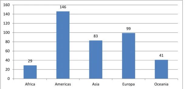
Figure 2: Forest and field wildfires by continent: EM-DAT database ... 20
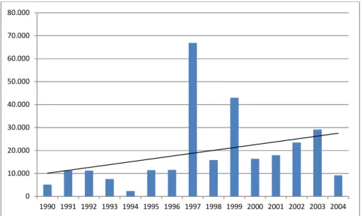
Figure 3: Forest and field fires records per year - EM-DAT database ... 21
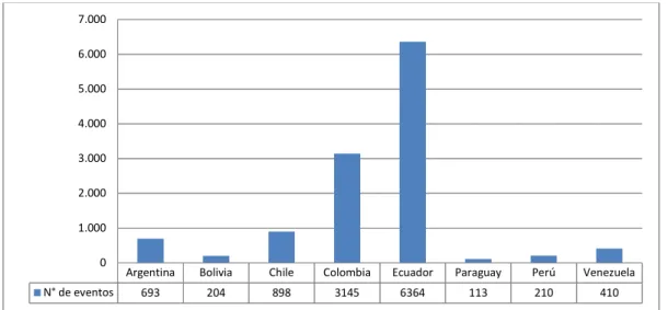
Figure 4: Number of forest fires in South America. Source: FAO ... 23
Figure 5: Number of burnt hectares in South America. Source: FAO ... 23
Figure 6: Number of fires between 1980 and 2015. Source: www.desinventar.org/es/. ... 24
Figure 7: Hectares affected between 1980 and 2015. Source: www.desinventar.org/es/r ... 24
Figure 8: Number of fires in Brazil between 1998 and 2015. Source: http://www.inpe.br/. ... 26
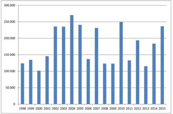
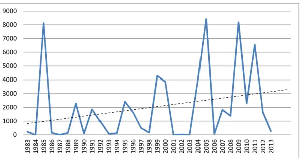
Figure 9: Number of fires recorded between 1983 and 2014. Source: SINAE ... 28
Figure 10: Yearly evolution in the number of forest fires. Source: SINAE ... 28
Figure 11: Evolution in the number of hectares burnt by forest fires in Uruguay. Source: SINAE ... 29
Figure 12: Amount of forest fires per department between 1983 and 2013 ... 31
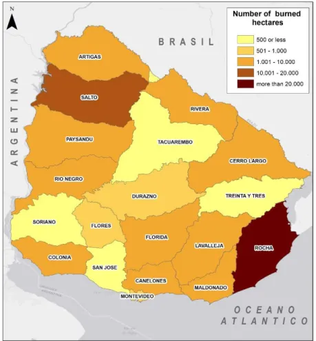
Figure 13: Number of hectares affected by forest fires per department between 1983 and 2013 ... 32
Figure 14: Accumulated forested hectare ... 37
Figure 15: Protected Areas Locations ... 48
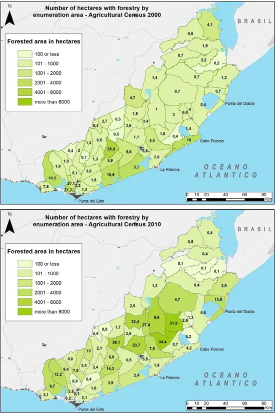
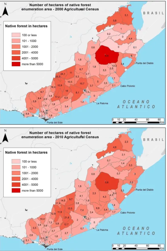
Figure 16: Forested area by department. Above map- Year 2000; Bottom map – Year 2013. Source: MGAP ... 52
Figure 17: Area with native forest by department. Above map: year 2000; Bottom map: 2013 ... 53
Figure 18: Artificial Forestry Maps by 2000 and 2010 enumeration areas ... 55
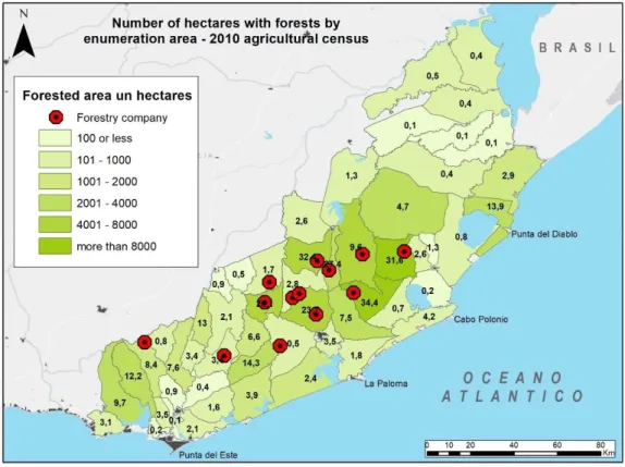
Figure 19: Location of Forested area and FAS forestry company sites. Own design. ... 56
Figure 20: Native forest Maps by enumeration area – years 2000 and 2010 ... 57
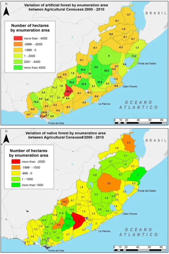
Figure 21: Absolute variations in artificial (above) and native (below) forests maps for the study area .... 61
Figure 22: Vegetation coverage by forest types (above) and native and exotic forest (below), year 2011. 62 Figure 23: Main land communication routes and populated centres on Uruguay’s Atlantic coast ... 73
Figure 24: Location of population centres (villages/towns/cities) along the Atlantic coast ... 74
Figure 25: Map of agriculture and livestock farming regions according to the agriculture and livestock farming censuses 2000 and 2010 ... 77
Figure 26: Number of international tourists visiting South America (millions). Source: World Tourism Organization ... 79
Figure 27: Population growth in cities/villages/towns between1963 and 2011 Source: National Statistics Institute. ... 83
Figure 28: Percentage of empty private houses by census segments – Maldonado and Rocha – 2011 census. Source: National Statistics Institute. Own design. ... 85
Figure 29: Housing/household ratio by village/town/city on Uruguay’s Atlantic coast. Source: National Statistics Institute. Own design. ... 86
Figure 30: Spectral signatures in vegetation and burnt areas. ... 97
Figure 31: Burnt area statistical description ... 98
Figure 32: Pre-fire: LC82220842015079 Punta del Diablo (20/03/2015) Band composition: 754 ... 99
Figure 33: Post fire: LC82220842015095 Punta del Diablo (05/04/2015) Band composition: 754 ... 99
Figure 34: Burnt area outline in Punta del Diablo using QGIS ... 100
Page | vi
Figure 36: NDVI Pre fire: LC82220842015079 Punta del Diablo (20/03/2015) ... 104 Figure 37: NDVI Post fire: LC82220842015095 Punta del Diablo (05/04/2015) ... 104 Figure 38: ΔNDVI < -0.2 cartography for the test area - Punta del Diablo ... 105 Figure 39: BAI Pre fire: LC82220842015079 Punta del Diablo (20/03/2015) ... 108 Figure 40: BAI Post fire: LC82220842015095 Punta del Diablo (05/04/2015) ... 108 Figure 41: NBR Pre fire: LC82220842015079 Punta del Diablo (20/03/2015) ... 109 Figure 42: NBR Post fire: LC82220842015095 Punta del Diablo (05/04/2015) ... 109 Figure 43: 1.74 < ΔBAI Cartography for the test area - Punta del Diablo ... 110 Figure 44: 0.35 <ΔNBR Cartography con for the test area - Punta del Diablo ... 110 Figure 45: Values for different indexes in the outlined burnt area ... 112 Figure 46: Comparison of the burned area according to NDVI, NBR and BAI indexes ... 113 Figure 47: Comparison of the burned area according to NDVI, NBR and BAI indexes ... 113 Figure 48: USGS Burn Severity classification for the test area - Punta del Diablo ... 114 Figure 49: Punta del Diablo’s burnt area outlining wiht AQL2004 index ... 115 Figure 50: Burnt area comparative according to Burn Severity and AQL indexes - Punta del Diablo 30/03/2015; 70 ha ... 116 Figure 51: Burnt area comparative according to Burn Severity and AQL indexes La Esmeralda -
26/12/2013; 50 ha ... 116 Figure 52: Supervised classification Landsat 8 image LC82220842013217 (05/08/2013) ... 117 Figure 53: Supervised classification Landsat 8 image LC82220842015079 (20/03/2015) ... 118 Figure 54: 1 km2 grid applied on the study zone for index calculation ... 122
Figure 55: Houses grouping in the forested area ... 123 Figure 56: Mapping of occupation in Punta del Diablo - La Esmeralda ... 124 Figure 57: Adjacency mapping for a cell Punta del Diablo - La Esmeralda ... 124 Figure 58: Adjacency mapping - Punta del Diablo - La Esmeralda ... 125 Figure 59: Dispersion mapping - Punta del Diablo - La Esmeralda ... 126 Figure 60: Housing vulnerability index mapping - Punta del Diablo - La Esmeralda ... 128 Figure 61: Overlap of Houses and forests location with the housing vulnerability index grid . 128 Figure 62: Opinion about benefits of forestry one the Atlantic coastal area ... 146 Figure 63: Types of forest that should be present on the Atlantic coastal area ... 147 Figure 64: The most important functions acknowledged for forests on the Atlantic coast ... 147 Figure 65: Main problems affecting forested areas on the Atlantic coast... 148 Figure 66: Main causes for forest fires spreading ... 149 Figure 67: Most visible impacts of forest fires on the Uruguayan Atlantic coast ... 150 Figure 68: Near future perception for relevant aspects of the Atlantic coast area. ... 151 Figure 69: Perception about the future of forestry in the Atlantic coastal area ... 152 Figure 70: Perceptions about the community’s behaviour in the near future. ... 152 Figure 71: Choice of future scenarios ... 153
Page | vii
LIST OF TABLES
Table 1: Plantations with forestry as main source of income: number of holdings, area used, surface with artificial forests and employed labour force in 2011 (census year) according to intensity of forestry ... 43 Table 2: Commercial farms: number of farms, harvested area and employed labour force in 2011 (census year), as main source of income from the exploitation ... 44 Table 3: List of Protected areas within the National Protected Areas System... 49 Table 4: Protected Areas within the study zone according to declaration ... 50 Table 5: Total area of woods (in hectares) by species and department. Year 2013 ... 51 Table 6: Natural and Artificial forest surfaces in the study area: per department and per ... 54 Table 7: Percentage of growth - 1963 -2011 censuses – Urban population centres ... 83 Table 8: Smaller seaside resorts on the Atlantic coast. Source: National Statistics Institute ... 84 Table 9: Spectral signatures data from the image’s coverages ... 101 Table 10: Burn severity levels obtained calculating ∆NBR, proposed by USGS. ... 114 Table 11: Area for each category according to the supervised classification, ... 117 Table 12: Area for each category according to the supervised classification, ... 118 Table 13: Type of burnt coverage by Burn Severity and AQL 2004 indexes in the analysed fire events . 119 Table 14: Weighing of the occupation variable ... 123 Table 15: Weighing of the adjacency variable ... 125 Table 16: Weighing of the Dispersion variable ... 126 Table 17: Housing vulnerability categories ... 127
Page | ix
LIST OF ACRONYMS
AECID │ Spanish Agency for International Development Cooperation AFE │ Trains and Tramways State Office
AQL 2004 │ Acceptable Quality Level 2004
AVC │ Vulnerabilities and Capabilities Analysis AVHRR │ Advanced Very High-Resolution Radiometer BAI │ Burned Area Index
BID │ Inter-American Development Bank (IDB) CCI │ Climate Change Initiative
CDE │ Departmental Emergency Committee
CECOED │ Departmental Emergencies Coordination Centre
CEPAL │ Economic Commission for Latin America and the Caribbean CONAF │ National Forest Corporation of Chile
CPTEC │ Weather Prevision Centre and Climate Studies CRED │ Centre for Research on the Epidemiology of Disasters CRID │ Regional Disaster Information Centre
DIEA │ Agricultural Statistics Office DINAMA │ National Environment Office DINOT │ National Land Planning Office DNB │ National Fire Brigade
Page | x
ECOPLATA │ Integrated Coastal Zone Management of the Rio de la Plata Support Programme EM-DAT │ Emergency Events Database
ENCE │ National Pulp Company of Spain ENSO │ El Niño Southern Oscillation ESA │ European Space Agency ETM │ Enhanced Thematic Mapper
FAO │ Food and Agriculture Organization of the United Nations FLACSO │ Latin American School of Social Sciences
FREPLATA │ Environmental Protection Project for the River Plate and its Maritime Front FSC │ Forest Stewardship Council
GDP │ Gross domestic product GIS │ Geographic Information System GWFN │ Global Wildland Fire Network
HRV │ High Resolution Visible INE │ National Statistics Institute
INPE │ National Institute for Space Research IPCC │ Intergovernmental Panel on Climate Change IRIF │ Forest Fire Risk Index
IRS │ Indian Remote Sensing Satellites
LA RED │ Social Studies Network for Disaster Prevention in Latin America LAPAN │ Indonesian National Institute of Aeronautics and Space METT │ Management Effectiveness Tracking Tool
Page | xi
MGAP │ Ministry of Livestock, Agriculture and Fisheries MODIS │ Moderate Resolution Imaging Spectroradiometer MVOTMA │ Housing, Land Planning and Environment Ministry NASA │ National Aeronautics and Space Administration NBR │ Normalized Burn Ratio
NDVI │ Normalized Difference Vegetation Index NGO │ Non-governmental organization
NOAA │ National Oceanic and Atmospheric Administration OLI │ Optical Land Imager
PATFOR │ Land and forestry planning participative instrument from la Generalitat Valenciana PROBIDES │ East Wetlands Biodiversity Conservation and Sustainable Development Programme PROBIO │ Project for the Electricity Production from biomass in Uruguay
RRD │ Disaster Risk Reduction
SAyDS │ Secretary of Environment and Sustainable Development (Argentina) SCP │ Semi-Automatic Classification
SINAE │ National Emergency System SNAP │ National Protected Areas System
SPOT │ Probationary System of Earth Observation SWIR │ Shortwave Infrared
TM │ Thematic Mapper
TOA │ Top-of-the atmosphere
Page | xii UICN │ International Union for Conservation of Nature
UN │ United Nations
UNEP │ United Nations Environment Programme
UNESCO │ United Nations Educational Scientific and Cultural Organization UNIDDR │ United Nations Office for Disaster Risk Reduction
UNISDR │ United Nations International Strategy for Disaster Reduction
UN-SPIDER │ United Nations Platform for Disaster Management and Emergency Response UNWTO │ United Nations World Tourism Organization
UPM │ United Paper Mills Ltd.
USGS │ United States Geological Survey VGI │ Volunteered geographic information WGII AR5 │ Working Group II Fifth Assessment Report WHO │ World Health Organization
Page | 1
CHAPTER 1 INTRODUCTION
1.1. Scope of the investigation ... 2 1.1.1. The forest fires problem ... 2 1.1.2. Forest fire risk integrated management ... 3 1.1.3. Geographic information technologies applied on burnt areas. ... 6 1.1.4. Specific features of forestry on the coastal area. ... 7 1.1.5. Public participation in forest fire management. ... 8 1.2. Aims and objectives ... 9 1.3. Investigation design ... 10 1.4. Thesis structure ... 11
Page | 2 1.1. Scope of the investigation
This work aims at learning about forest fire risk on the Uruguayan Atlantic coast; as a relation established between the social group occupying a specific space in terms of its characteristics as well as the activities that are developed there. This is a particular bond built for almost a century and that can be summarized as nobody’s forest becomes everybody’s risk.
1.1.1. The forest fires problem
The Climate Change 2014 Report: Impacts, Adaptation, and Vulnerability has been endorsed this year. It was developed with contributions from the 5th Work Group II del IPCC (WGII AR5, 2014) and it addresses
forest fires as climate-related extreme events that show how some ecosystems and a lot of human systems, are particularly exposed and also vulnerable to the current climate variability. In addition, the report states that countries at all development levels have a significant lack of preparation to face the aforementioned climate variability in several areas and spaces.
The Special Report - Managing the Risks of Extreme Events and Disasters to Advance Climate Change Adaptation (Cuny, 1983; Blaikie et al., 1996; CEPAL &BID, 2000; Cardona, 2001) approaches this topic from disaster theory and the social concept of risk. It states that in those cases when exposure and vulnerability are high, non-extreme phenomenon may bring about extreme impacts or they may even worsen the phenomenon and their associated impacts, as well. It uses the drought chain as an example; drought, extreme heat and humidity increase fire risk related to different vulnerabilities. These, in addition to changes in the hydrologic cycle and biochemical alterations may result in quite relevant degradation processes (Dinis Ferreira et al., 2010).
The Food and Agriculture Organization of the United Nations (FAO, 2007) warns about an increase in the number of forest fires as a consequence of climate change. These events are increasingly larger and have more terrible effects in several parts of the world. Therefore, it calls countries to invest more in prevention and preparation to face fire events. Fires are frequently a consequence of human negligence or willful acts; they destroy millions of forested hectares, resulting in human and animal life losses and causing huge economic damage. This organization calculates that every year forest fires all around the world consume around 5 130 million tons of biomass and release 3 431 million tons of CO2 in the atmosphere. These
contribute to greenhouse effect emissions to increase climate change.
This organization finally suggests the need to implement preventive landscape management, comprising political, cultural, technical, social, financial, organizational, economic and market aspects. The concern
Page | 3
regarding these events and their effects is noticeable because of variety of global and regional initiatives that have the aim of looking into them and improving their management.
In the Manual de Classificação de Incêndios Florestais used by the Instituto da Conservação da Natureza e das Florestas de Portugal (Buxo de Carvalho & Lopes, J., 2001), forest fires are defined as fire spreading uncontrollably on forested territory, affecting vegetation that was not meant to be burnt. Based on this definition, it can be understood that forest fires affect vegetation not used with agriculture and livestock breeding purposes and they do not comprise stubble burning. This definition is complemented by The National Forestry Corporation (CONAF) at Chile’s Agriculture Ministry, as it adds a reference to the resulting damage and the differences between forest fires and controlled fires. In other cases, the term “rural fire” arises, to define fires affecting areas that aren’t forested or apt for forestry. Instead, it takes place in other rural areas and affects brushwoods, bushes and grasslands. These events may result in important damages to the area’s flora, fauna, hydric resources and soils, which may have a highly negative result on tourism-oriented areas. There are also interface fires. These take place in urban-rural areas where the vegetation mingles with building structures, such as houses, farm houses, etc.
The immediate effects of fire include the total or partial destruction of the area’s vegetation, which is followed by an erosion process that depends on the atmospheric conditions present before and after the fire. The speed at which the area regenerates may vary, depending on what type of vegetation has been affected. In areas such as grasslands, for example, where the trees do not predominate, regeneration is quite quick. Consequences are more serious when the fire destroys a forest, the underbrush or ecological niches that are often unique. The ENSO Risk Management Project Report for Latin America states that forest fires are usually started on agricultural or livestock production lands and usually bring about severe environmental damage (Magaña et al., 1999).
In addition, forest fires have become a global issue because of their emissions to the atmosphere and also because sometimes they cross borders, as it has happened in the Mediterranean region (García - Hurtado et al., 2014) and more recently in Rio Paraná’s delta (Salvia et al., 2012).
1.1.2. Forest fire risk integrated management
Even though forest fire risk is associated to natural variables such as vegetation, meteorological conditions and topography, it is specially linked to human activities that determine how fire starts and spreads. The fire’s degree of danger depends on its risk level and its interaction with human activities. According to Hewitt (1996), and from the perspective of physics, fire is a “natural” risk; nevertheless, assuming a more integral perspective, fire can be related to human activities and can endanger assets such as infrastructures,
Page | 4
structures and productive dynamics as well as ecosystems and landscapes. In addition, there is a collective and individual dimension to these events that questions how the public budget is distributed regarding fire-fighting. This is because collective costs in high fire risk areas are more focused in urban development, only trying to make profit of the landscape’s value (Napoléone et al., 2006).
Even though natural disasters are increasingly frequent and damaging mainly because of global climate change and variability (Baas, S. et al., 2008), the specific case of forest fires can be analysed as a social phenomenon highly linked to a historical construction of socioeconomic, environmental and institutional vulnerability (Gasparotto, 2002). Olcina (2006) defines risk as ‘human actions happening in disagreement with their environment’s features; it is, therefore, a man’s violation on the land by inadequately implanting activities or settlements’. This is a changing, evolving and dynamic condition that is affected by social and environmental processes (Lavell, 2001) and is expressed in the possibility of future losses.
In the case of forest fires and taking into account the anthropic action of the settlement, Napoléone et al. (2006) conclude that natural environments are structured by the houses’ location and the urban expansion, affecting the biodiversity and therefore, the combustible’s quantity and quality. They also state that the landscape and natural environment’s quality affect the decision of where to locate houses and, consequently, the urban development. These interactions make us aware of the need to take into account the prevailing natural and social conditions in a certain territory in order adequately analyse its fire risk conditions.
Napoléone et al. (2006) also state that in the Mediterranean region the structure and composition of forested areas determined their sensitivity to forest fires. Such sensitivity is expressed through the concepts of combustibility and inflammability. Combustibility is understood as the forested mass’ quality to start and keep and oxidation reaction and it determines the fire’s intensity. Inflammability, on the other hand, is the set of conditions present in that forested mass’ surroundings that allow fire to start when a heat source is applied. However, the territory is also affected by anthropic space structures. The more scattered houses are, the more contact between human activities and the environment takes place. Considering that most fires have anthropic causes and vulnerability is strongly linked to the presence of houses, the limits of urban structures acquire considerable impact on fire risk. Also, the difficulties in accessing those areas and in keeping the surrounding zones clean add up to the risks.
It seems critical for fire prevention policies to include the space patterns in fire generation and spreading as well as their relation with geographical and socioeconomic variables, especially, the settling and urbanization processes. Chas-Amil et al. (2010) analyse fire reports for the 1988-2006 period in Galicia, España. They explore fire risk space distribution considering human activity, causes and subjacent motivations related to those events. The differences that arise in their investigation emphasize the need to have some valuable
Page | 5
information available. Such information leads to detect some non-random variable groups that permit a better knowledge of fire causes in certain places. This would be essential information to thoroughly assess and later integrate in fire management planning.
In Uruguay, the institutions in charge and the funding available for forest fire control are public. This means that forest fire risk is linked to those institutions’ capacity to control fire, that is to say, to develop an integral risk management plan that considers the forest fire threats and vulnerabilities placed by settlement’s shapes and activities. Within management, individual incidence depends on how fire-fighting institutions are funded and on the availability of insurance options. This brings along a dilemma regarding the individual nature of housing options, which are part of the causes of risk, and the public structure of fund risk management. From the perspective of vulnerability, risk may be compared to the variation in the value of assets or individual profit associated to these events happening. Napoléone (2006), nevertheless, concludes that there is no mechanical relation between the objective value of goods and risk; the real nature of risk lays on the occurrence that individuals assign to such risk.
Risk is a concept close to that of uncertainty, as risk probabilities can be calculated. Assuming that individuals have the same and sufficient information, risk results from a relationship between the uncertainty of factors and the impacts of that risk’s occurrence. From this point of view, and assuming that there is an aversion to risk, risk is tightly linked to the prevention of individuals. Consequently, and regarding risk occurrence and the resulting costs distribution, Napoléone (2006) observes that those depend on “individual sensitivity levels” towards fire risk.
The circumstance surrounding fires may bring along severe risk or disaster situations that require risk planning and management; those situations require special planning for some territories. (National Emergencies System creation Law Nº 18.621, Decree 436/07 within the General action Plan of Forest Fire Prevention, Alert and Response).
To take adequate prevention and response measures and, therefore, reduce the effects of fire on the most vulnerable zones, it is indispensable to analyse the territorial distribution of vulnerability and the potential fire danger level as well as its components. On the other hand, assessing an area that has been affected by a forest fire is paramount to understand the event, from a preventive point of view as well as from the perspective of planning and restoration. Analysing the effects of fire on a certain territorial reality helps understanding the incidence that the different variables within this problematic have.
Page | 6
1.1.3. Geographic information technologies applied on burnt areas.
The relevance of forest fires stems mostly from two factors: they deteriorate the environment (destroying forest mass, eroding the soil, affecting the atmosphere), and they also have socioeconomic impacts. Burnt areas cartography is an acknowledged and useful ex-post tool when planning palliative actions to address their effects (Blas Morato, R.et al., 2006). In addition, cartography can fulfill the need to assess vulnerability (degrees of damage and loss in the population, goods and environment resulting from a forest fire) and to assign –based on the forestry system intrinsic and extrinsic factors - potential degrees of gravity in case of fire to each spot of the territory.
Moreover, the forestry system’s combustibility is defined by its capacity to keep and spread fire. Each kind of vegetation has its own specific degree of combustibility and flammability, which vary according to the biomass’ type and amount and its space distribution or stratification. Combustibility analyses may be carried out using visually identifiable structural models called combustible models (Rothermel, 1972; Albini, 1976, Scott & Burgan, 2005). Such models allow forecasting how fire will behave.
Current Geographic Information Technologies enable a more successful approach to this topic. Remote sensing is a highly useful tool to assess areas that have been affected by forest fires. Satellite images supply updated space information, and their digital improvement provide highly precise cartography of burnt areas that enables to spot the affected perimeter, tell burnt areas from the ones that are not, quantify the main affected species, etc. (Blas Morato, R.et al., 2006).
In order to define the threat placed by forest fires, burnt areas can be outlined so as to find out the events’ dimension and frequency; it is also possible to search for possible distribution patterns and types of combustibles affected (Diaz-Delgado et al., 2004; Curt et al. 2013). Landsat satellite images can be digitally improved in order to obtain indexes and classifications that discriminate burnt from not burnt areas. Those indexes include: Normalized Difference Vegetation Index (NDVI), Normalized Burn Ratio (NBR), Burned Area Index (BAI), or more complex ones, for example: Burn Severity and AQL 2004. Strengths and weaknesses of each technique to develop cartography of burnt areas become evident when comparing results obtained through different methods. Such comparison states how convenient it might be to apply each technique to identify the burnt zones inside the study area.
Page | 7 1.1.4. Specific features of forestry on the coastal area.
Forest fires take place regularly in Uruguay’s coastal area during the summer season and they result in large economic and environmental losses. Reports about Climate change state an increase in the frequency and intensity of forest fires as a consequence of external climatic effects, such as the droughts that take place in the region (Proyecto URU/00/G31, 2004). Forest fires are environmentally relevant events because they have a negative impact on every action taken towards the conservation of the environment and its natural resources; they bring about vegetation losses, and have short, medium and long-term consequences as they reduce biodiversity and cause erosion. An analysis of forest and field fires regarding their number and affected surfaces is crucial in order to keep environmental values in Uruguay’s regions.
In Uruguay, forestry has greatly developed as a productive activity in the last twenty years encouraged by State’s policies (Law 15939 and its following decrees). However, the most aggressive forest fires have taken place on the coastal area, far from forestry production fields; they have usually been hard to put out and have caused severe damage. They destroy the landscape; cause panic in inhabitants and tourists (that concentrate in the area in the summer season); affect some infrastructure; and mobilize equipment and personnel to fight the fire, among other consequences. Even though human lives are not usually lost, that is a potential danger. There are, however, other harmful effects to human life and to the environment derived from the fire’s emissions.
Fog and smoke can negatively affect aviation, sailing and vehicles circulation, and this means security hazards and economic losses (FAO, 2007). The Atlantic coastal region, where most of these events have taken place, has a high tourism value and comprises many spaces included in the National Protected Areas System.
Forests began being implanted on the Atlantic coast over a century ago; exotic species were introduced with the aim of fixing sands and then selling the land. The landscape’s characteristics then changed, turning into what today many see as the Eastern seaside resorts typical scenery. Furthermore, a scattered type of land occupation was encouraged by poor planning, uncontrolled land divisions and a lack of services. As time goes by, exotic forestry starts competing aggressively with native vegetation and some species that are well-adapted to fire colonize areas that used to be covered by indigenous forest; along this process the coast turns into a more combustible area.
Page | 8 1.1.5. Public participation in forest fire management.
According to FAO Forestry Paper 166 “Community-based fire management. A review” (2011), the participation of communities in forest fire management is paramount, mainly because most of those events are a result of human activity. Such perspective is also encouraged by the “Instructor’s Forest Fire Management Manual” (2010). The underlying idea is that when local communities profit from protecting their natural resources, they are more likely to work on fire prevention.
Several authors agree that complex problems, such as forest fires, require public participation (Carreiras et al., 2014; Parkinson et al, 2003). A multi-sector approach becomes valuable as it allows learning about the interests of different sectors and stakeholders, and it helps to acknowledge and understand the economically weakest groups’ logic, interests, motivations and strategies, granting their participation in negotiations where they can stand up for their interests. The main aims of these actions are: bringing about the sensitivity of those in charge of outlining and managing public policies; reaching agreements regarding the scope and negative effects of not acting; and identifying and approaching together the causes of unplanned forest fires. The stakeholders’ participation (including the local community and the private sector), may contribute to a long-term financial sustainability. Fair and productive partnerships between companies and communities can have a strategic value for investors, going beyond the companies’ corporate social responsibility objectives.
The concept of social perception and its contribution to public participation research is becoming more and more crucial when defining the management of goods or resources of public use. Muhamad, D. et al., (2014) use as examples the perceptions that local inhabitants, administrators and victims of their degradation have of ecosystem services. Understanding this becomes fundamental to apprehend the sociocultural dimension of ecosystem services, identifying which of those services are the most appreciated and preferred (Martín-López et al., 2012) so as to implement a successful conservation plan (Kari & Korhonen Kurki, 2013) while fulfilling the people’s everyday needs.
On the other hand, this author warns about the possibility of different perceptions arising. Such multiplicity may be result of housing locations, cognitive aspects and implicit categorizations underlying people’s interpretations of their surroundings, based on different space and time scales (Hein et al., 2006; Rodríguez et al., 2006) that are grounded on their own personal experiences (Berkes, 1999; Campos et al., 2012). This heterogeneity may bring along richness and more solution options, though.
Finally, it is worth mentioning the new communication options supplied by the 3.0 web. A large number of people who are interested in interchanging opinions can be questioned easily, without time or mobility restraints. This technology supplies new participation channels, not only by forums and surveys, but also by
Page | 9
voluntary geographic information (VGI) and by using mobile phones to pass information picked by sensors. Even though these new participation methods are being discussed and are only partially accepted, they seem to be not only supplying data, but also promoting a type of social behaviour that encourages connectivity, a better understanding local forest fire risk and higher participating in risk reduction actions (Granell & Ostermann, 2016; Haworth et. al., 2016).
1.2. Aims and objectives
The aim of this investigation is to know forest fire risk on Uruguay’s Atlantic coastal strip by analysing the interaction of its two dimensions: on one hand, the threat, which will be identified through forest fires themselves, and specifically analysing areas burnt in those events; on the other hand, the vulnerability that is a result of populated areas’ exposure. The study area has a surface of 3 500 km2 and it is one the country’s
most visited tourist destinations (32% according to the Tourism and Sports Ministry data, 2014). It has a variety of landscapes (protected areas comprise 20% of its surface: Cerro Verde, Cabo Polonio, San Miguel Park, Rocha Lagoon and El Potrerillo de Santa Teresa National Park and Fauna and Flora Reserve), and it will go through major productive changes in the near future, such as the construction of a deep waters port. Forest fires take place in these surroundings and mainly in the summer season, usually with anthropic causes.
This investigation aims at learning about the characteristics that breed forest fire risk on Uruguay’s Atlantic coast. How has the area evolved to give birth to the current vulnerability matrix? What perceptions do its inhabitants have regarding that transformed landscape and the different government levels management? Is it recommendable to use geographic information technologies to locate the main forest fires and to know a small proportion of the present vulnerability through indexes? What policies and regulations are there to contribute to risk reduction?
A territory’s vulnerability can be seen as the result of the interaction between environmental conditions and society; it is a combined effect of exposure to danger, different territorial component’s sensitivity and the resilience or capacity to recover. The present investigation looks into the population settlements’ vulnerability resulting from their exposure. In addition to traditional variables, for instance, number of inhabitants, housing quality or socioeconomic aspects, it is relevant to analyse the houses’ degree of exposure to forest fires. Geoprocessing indexes – occupation, adjacency and dispersion - are applied in order to know how houses are distributed within the forested matrix.
Page | 10
By looking into current public policies and regulations regarding forest fire as well as the communities’ forest fire risk perception it is possible to know: which areas are perceived as having the highest risk; the main factors that the local population associates to such risk; and how that population values policies and regulations regarding risk in their area.
The hypothesis underlying this investigation is that the outset of forest fire risk reduction can be at approaching the issue from a perspective that involves scientific knowledge and public participation, and is based on the different actors’ participation, specially administrators and local inhabitants, in order to set up decision-making processes to prevent these events within the land planning regulations.
1.3. Investigation design
The investigation is composed of two stages:
Evaluating risk through the use of geographic information technologies. First, identifying burnt areas in order to calculate the threat and then, recognizing the forest through a supervised classification in a test region that comprises the whole study area. This task uses Landsat 8 images from the two major fires of the last 10 years. Then, vulnerability is expressed by human settlements present in the area; their distribution is taken as a measure of their exposure (analysing their occupation, adjacency and dispersion regarding the forested mass).
Secondly, public participation and the community’s perception are analysed through workshops and surveys. According to a variety of authors, a participative community is crucial in decision-making processes that aim at environmental and technological risks fighting and management (Figueiredo, E. et al, 2009). According to Ribeiro, C. et al (2014), although Portugal’s government policies include a variety of measures to reduce forest fires, the frequency of those events keeps high. The article’s conclusion is that technicians as well as local inhabitants have varied perceptions about forest fires and forestry management. Such differences, that are a result of their varied interests and different intervention scales, must be minimized in order to achieve risk reduction. Current public policies regarding forest fires as well as the actors’ perceptions about them are looked into at this stage and also later, through a specific analysis.
Page | 11 1.4. Thesis structure
After this introduction chapter (Chapter 1), Chapter 2 includes a review of forest fires at a global level, then in Latin American and, finally, looks at the events taking place in Uruguay. At this stage, the Atlantic coast area is acknowledged as the most affected by not programmed forest fires.
Chapter 3 analyses the structural transformations of the territory as a result of the forestry policy developed in the 80s. Then, it focuses on the study area, as it depicts an uneven evolution in terms of stages, types of exotic forestry and its uses and current results regarding forest fire generation.
Chapter 4 develops a more thorough look at the Atlantic coast region, where there are remarkable ecosystem values within a major tourist attraction area. This chapter shows how incompatible those two features have become, in addition to the unplanned urban development of forested areas.
Chapter 5 presents the results obtained from applying tele-detection in the recognition of burnt areas and soil uses. The areas with the highest risk within the test study area are determined by crossing vulnerability indexes. These tools are applied with the aim of contributing with a perspective that had never been used in forest fire analysis in Uruguay.
Chapter 6 presents observations collected in the participative workshops - which had the aim of outlining a forest fires management plan - as well as results from the online survey applied to agents in the tourism area. These findings were the result of the joint work of administrators from different areas and decision levels, inhabitants from La Paloma and La Pedrera municipalities interested in the topic, and researchers from Science School and the NGO Cultura Ambiental.
Chapter 7 presents and analyses rules and regulations regarding risk management, forestry and land planning in Uruguay, with the aim of spotting deficiencies and conflicts in regulations, tools and management plans.
Finally, Chapter 8 presents the investigation’s main findings and conclusions that could contribute to improving public policies and forest fire risk-reduction actions on the Atlantic coast. It also includes difficulties and obstacles faced along the development of this thesis as well as open future research lines.
Page | 13 CHAPTER 2 FOREST FIRE RISK
2.1. Introduction ... 14 2.2. Forest fires, a complex issue. ... 14 2.2.1. The beginning of the threat, physical characteristics that contribute to starting a forest fire. ... 14 2.2.2. The El Niño Phenomenon and forest fires ... 15 2.2.3. Environmental effects and Global Warming ... 17 2.2.4. Vulnerability, creation of socioeconomic and cultural development? ... 18 2.3. A review of events: international level, regional level and the Uruguayan territory. ... 19 2.3.1. Forest fires in the world. ... 19 2.3.2. Forest fires in the South of Latin America. ... 22 2.3.3. Forest fires in Uruguay. ... 27 2.4. Discussion and conclusion. ... 32
Page | 14 2.1. Introduction
Forest fires result from an interaction between the physical environment and anthropic actions and they have major effects on the population as well as on the environment. It is because of this two-way relation that studying forest fire risk from the perspective of geography is paramount. In addition, the geographical character of some main fire risk factors, such as the vegetation’s conditions, climate conditions, land’s topography and anthropic activity – which is the main cause of these fires – makes an integrated territory analysis necessary (Chuvieco et al., 1998).
When studying risk – understood as a combination of vulnerability and threat - a historical analysis of forest fire events becomes a relevant starting point. On one hand, the number of events and their space distribution may allow to identify how the threat behaves, and on the other hand, studying the effects of these fires may provide an idea of how vulnerable to these events some areas are. As Rodríguez (2012) states for Bolivia’s case, not having precise information makes control and prevention incomplete actions and this, in turn, results in the need to study forest fires space and time patterns.
This chapter includes a first approach to a historical analysis of forest fires in Uruguay, beginning with a brief analysis of the world’s context and ending in the national reality.
2.2. Forest fires, a complex issue.
2.2.1. The beginning of the threat, physical characteristics that contribute to starting a forest fire.
Fire works as a natural ecological regulator for terrestrial ecosystems, shaping the planet’s biomes. However, it does not only work as a great herbivore (Mataix-Solera & Cerda, 2009) contributing in the short term to species’ selection and to the vegetation formations composition (Navarro et al., 2008), but also contributes to speeding up geomorphological process through its effects on soil infiltration and, as a consequence, its runoff. This way, fires generate changes in erosive processes as well as participating in soil formation processes by modifying their nutrients cycle and their physical and chemical properties (Mataix-Solera & Cerda, 2009).
There have been fires on planet earth for the last 350 million years (Scott & Glaspool, 2006; Mataix-Solera & Cerda, 2009), but human activity has added up to the natural fire regimes. The first records date back to
Page | 15
1.5 million years; in the beginning fire was used for defence, hunting, and as an energy and food-production source. Nevertheless, as time went by, it became increasingly relevant as a way of opening crop-growing areas. Such was the case that a controlled use of fire had already begun in Neolithic, while it was no longer used for hunting purposes. Even at present day, fire is used in agriculture for burning crops leftovers and controlling plagues (Mataix-Solera & Cerda, 2009).
There are three necessary components to start a fire: oxygen, some combustible material and heat: these three are known as “the fire triangle”. All these elements can easily be found on the earth’s surface, turning fires into ordinary events. Even though thunderstorms and volcano eruptions are fire’s most frequent “natural” causes (Castillo, Pedernera, & Peña, 2003), it is the current anthropic activity the main cause of fires. It is believed that human beings start 95% of forest fires due to their economic, recreational and war activities (Vélez, 1995). Human-started fires take place worldwide and it is believed that between 10 and 15 million hectares of words are lost yearly as a consequence (Castillo, Pedernera, & Peña, 2003).
There are some risk factors for forest fires, being one of them the vegetation’s hydric conditions. These conditions are determined by variables that include: air’s temperature and humidity, wind’s speed and direction and rainfall (Chuvieco et al., 1998). However, the same meteorological setting may have variable effects depending on the conditions of the vegetable combustible.
2.2.2. The El Niño Phenomenon and forest fires
Meteorological conditions are frequently affected by the Southern Oscillation-el Niño (ENSO), known as El Niño, which is a phenomenon that begins in the south of the Pacific Ocean and impacts in several parts of the world. It is characterized by a warm phase – El Niño – followed by a cold one – La Niña. When the equator’s characteristic trade winds weaken, they make Polynesia’s warm waters move to the East and high temperatures bring about convective activity, which results in periods of intense rain in South America’s coasts. On the other hand, during La Niña phase trade winds grow stronger, allowing colder waters from the ocean’s bottom to rise. Even though this process seems to be local, along its warm phase makes tropical areas in northern South America go through a drought stage, while there are heavy rains in southern areas. In Uruguay there are drought periods during its cold phase.
Why does drought have such relevance in the origin of forest fires? The explanation lies in the three combustion stages of vegetable materials. In the first stage, warming-up takes place and materials reach 100ºC, marking the beginning of water vapour loss. In the second stage, there is gas combustion and temperature reaches 300º, flames start and heat keeps the combustion process going. Finally, the carbon combustion phase takes place, where heat and oxygen are used up, generating ashes which no longer burn. This final point does not only depend on meteorological conditions, but also on the summation of all
Page | 16
previous conditions. This is how the humidity content is crucial to starting as well as to spreading fire. This means, in turn, that the longer the drought, the less humidity there will be in the vegetable material and, as a consequence, there are higher chances of fires beginning and spreading (Vélez, 1995).
Figure 1: ENSO phenomenon phases. Source: NOAA
It is for this reason that the ENSO phenomenon and the development of forest fires bear direct relation. It is possible to observe El Niño and La Niña periods along the last century measured by the Multivaried ENSO Index1: warm periods in read and cold ones in blue (Figure 1). In 1998 its warm phase reaches a peak known as MegaNiño. According to FAO data, only in Roraime State (Brazil) 1.1 million hectares of virgin
1 The Multivariate ENSO Index combines the most important variables in the tropical Pacific: sea level atmospheric pressure, zone and southern wind component, surface-level sea temperature, air temperature and cloudiness, supplying a starting point to measure the events’ magnitude.
Page | 17
woods were on fire in that year, and this clearly illustrates the relevance of this event for the development of fires.
2.2.3. Environmental effects and Global Warming
The emission of gases and particles resulting from the combustion of biomass comes as the most immediate effect of forest fires. In such fires, carbon dioxide that has been stored in trees for decades is released to the atmosphere and therefore, if the vegetation cover is not regenerated, carbon dioxide will remain there (Castillo, Pedernera, & Peña, 2003). This is how greenhouse effect gases emissions in forest fires greatly contribute to global warming, not only by releasing carbon dioxide but also methane and other gases and aerosols, some of which are even air contaminants (e.g. van der Werf et al., 2010; Spracklen et al., 2009 en Huang, Wu, & Kaplan, 2015). This is probably one of the most critical consequences of forest fires, as they contribute to greenhouse gases emission and thus, to global warming. Meanwhile, the planet’s increase in temperature builds up the conditions necessary for the development of further fires. This is how an increase in forest fire impacts on climate change while climate change contributes to a rise in forest fires (FAO, 2005). According to NASA (2012) and FAO (2012), global warming will lead to an increase in fires and periods of drought in some regions as well as to a decrease in rainfall (Rodríguez et al., 2012). Not only the meteorological modifications derived from climate change foster a multiplication of fires, but these also depend on the vegetation cover; in the next years, climate change as well as an increase of carbon dioxide in the atmosphere can lead to major disturbances in the vegetation cover (Wu et al., 2012; Bachelet et al., 2003 in Huang, Wu, & Kaplan, 2015). These changes result in a variation of combustible availability and consequently, in the development of fires (Huang, Wu, & Kaplan, 2015).
Even though changes in the uses of the soil have had an impact in the multiplication of forest fires, it is also believed that global warming plays a paramount role (Meyn et al. 2007 Holz, Kitsberger, Paritsis, & Veblen, 2012). Climate change in conjunction with social variables, such as the introduction of fire in areas that are not fitted out for agriculture or an increase in their frequency in fitted-out areas, have transformed the natural cycles of fire (Bowman et al., 2009 in Holz, Kitsberger, Paritsis, & Veblen, 2012). As well as their global-level impact, fires have local impacts related to life and infrastructure losses, soil degradation and changes in vegetation and bio-diversity (Harrison et al., 2010 in Holz, Kitsberger, Paritsis, & Veblen, 2012). Moreover, fires bring along landscaping and edaphic consequences (Chuvieco et al, 1998) as soil’s erosion processes are accelerated by the lack of vegetation cover.
Castillo, Pedernera and Peña (2003) put together a list of forest fires’ consequences, dividing them into socioeconomic and ecological. Among the ecological impacts there is the aforementioned effect on climate