At the Center and the Periphery of Lusitania:
The Evolution of the City of Egitania and its Territory
(4
th- 8
thcenturies)
1***
T
OMÁSC
ORDEROR
UIZUNIVERSIDADE NOVA DE LISBOA
ABSTRACT
The Suevic-Visigothic episcopal city of Egitania (Idanha-a-Velha, Portugal), erected over the Roman city of Civitas Igaeditanorum, was located at the heart of the old Roman province of Lusitania. Yet, this space has been considered by scholars as secondary in the general context of the Iberian Peninsula during the Roman and Suevic-Visigothic periods (4th-8th centuries). The textual and archaeological records together allow a general reconstruction of the evolution of the city during those centuries, but detailed conclusions remain elusive due to our poor knowledge of the urban and rural inhabitants of Egitania. This subsequently prevents a clearer understanding of the social, economic and cultural dynamics of the city and its territory, which so far have not been sufficiently studied in tandem.
The following essay merges these disparate historiographical themes into a synthetic thesis. This research is twofold. First, I attempt to elicit a solid basis of historical information by analyzing the main lines of general evolution of the city and the broad interactions of the urban community of Egitania. Second, I examine rural communities, paying special attention to the analysis of how they relate to the city and to each other. This methodology is based on the research carried out on Emerita
1 This article has been translated from the original Spanish by Patricia Di Gialleonardo, Buenos Aires
(Mérida, Spain), capital of the Roman province of Lusitania and, later, of the Diocesis Hispaniarum. In this case, the landscape between the fourth and eighth centuries was structured by the superposition of administrative, economic, ecclesiastical and social networks that would unite the city with its territory. Thus, although recognizing that the city-territory relationship would have been variable in each region of the Iberian Peninsula, it seems fair to employ this epistemological model for analyzing Egitania.
ESSAY
Introduction
The different historical processes associated with the transformation of the city and the countryside in Western Europe during the fourth through eighth centuries encouraged the development of a new framework for relations between urban and rural worlds. A scenario developed in which the links between these two spaces, complementary and unwavering, would be defined by the new ties established between the elites and the rest of the social groups.2 In this evolution, the Church played a crucial role, both because of its political, social, economic and cultural influence as well as its ability to maintain a territorial administration based on the ancient Roman imperial institutions.3 In that model, the city acted as the core of its territory through symmetrical relationships; a system governed by a set of laws issued by the state apparatus ensuring the control of Rome.4 Urban-rural relations throughout the fourth through the eighth centuries became asymmetrical in character, since the
2 Michel Lauwers and Laurent Ripart, “Représentation et gestion de l’espace dans l’Occident
medieval,” in Rome et l’Etat moderne européen, ed. Jean-Philippe Genêt (Rome: École française de Rome, 2007), 3-11.
3 Michel Lauwers, “Territorium non facere diocesim. Conflits, limites et représentation territoriale du
diocèse, Ve-XIIIe siècle,” in L’espace du diocèse. Genèse d’un territoire dans l’Occident médiéval
(Ve-XIIIe siècle), ed. Florian Mazel (Rennes: Presses Universitaires de Rennes, 2008), 2-10.
4 María José Castillo Pascual, Espacio en orden: El modelo gromático-romano de ordenación del territorio (Logroño, 2011), 46-50.
conceptualization of the territory came to be defined by the type of place and not, as in the Roman world, by the type of property.
This appears to have resulted in a fragmentation of territorial structures in which each settlement operated as its own jurisdictional core.5 However, it does not seem that the consolidation of this model meant the disappearance of the old administrative system based on the ancient Roman towns remaining during this period, especially of those that became episcopal sees.6 In the case of Lusitania, for instance, various documents demonstrate the interest of the Church and the Visigothic monarchy in maintaining and recovering the provincial unit lost during the fifth century,7 an interest matched by the episcopal sees of Emerita or Egitania in the conservation of their territorial limits.8 Thus, it appears that the interrelations of countryside and city would have become in this period defined by their heterogeneity and the fragmentation of territorial jurisdictions. However, on them would overlap, with greater or lesser effectiveness and relevance, a political, social, economic and cultural structure controlled by the Church and, alternatively, the Suevic and Visigothic state, resulting in a new situation defined by the fragmentation of the old Roman system.9
5 Chris Wickham, “Un pas ver le Moyen Âge? Permanences et mutations,” in Les campagnes de la Gaule à la fin de l'Antiquité, ed. Pierre Ouzoulias, Christophe Pellecuer, Claude Raynaud, P. Van Ossel
and P. Garmy (Antibes, 2001), 566-67.
6 Chris Wickham, Una nueva historia de la Alta Edad Media. Europa y el mundo mediterráneo
(Madrid: Edición Destacada, 2008), 848-958.
7 See Pablo Díaz, “Propiedad y poder: la iglesia lusitana en el siglo VII,” in Los últimos romanos en Lusitania, ed. Agustín Velázquez, Enrique Cerrillo and Pedro Mateos (Mérida, 1995), 53-72.
8 Tomás Cordero Ruiz, El territorio emeritense durante la Antigüedad Tardía (siglos IV-VIII). Génesis y evolución del mundo rural lusitano (Madrid, 2013), 94-100; Tomás Cordero Ruiz, “La organización
de la diocesis Egitaniensis y la configuración territorial del interior de Lusitania durante la Alta Edad Media (400-800),” in press.
9 Michel Fixot, “La cité et son territoire: l’exemple du Sud-Est de la Gaule,” in Towns and their Territories Between Late Antiquity and the Early Middle Ages, ed. Gian Pietro Brogiolo, Paul Gauthier
Egitania: Suevic and Visigothic episcopal see
The Civitas Igaeditanorum, the old Roman core of Egitania, is first mentioned in the acts of the Council of Lugo, held in 569 in the Suevic Kingdom, in which Adoricus appears as Egestanae episcopus, the bishop who also signed the acts of Braga’s next council in 572.10 The precise causes that led to the appointment of Egitania as the Suevic episcopal are unknown, but can be reasonably assumed to relate to the survival of the city in a region – central Lusitania – in which the Roman urban system had been undergoing significant changes.11 In addition, its strategic location in the southwest corner of the Suevic Kingdom and the presence of a Christian community were likely influential (fig. 1). The baptistery located opposite the northern façade of the current Sé de Idanha-a-Velha has been related to this period. It was within a larger, probably cultural, complex with an opus signinum floor (fig. 2).12
Furthermore, the Visigothic conquest of the Suevic Kingdom in 585 subsequently led to the return of the administrative unit of the ancient Roman province of Lusitania, which had been broken in the fifth century.13 This reunification meant also the return of the Roman Catholic dioceses of Conimbriga, Viseu, Lamecum and Egitania to the Lusitanian Church administration and their subordination to the Metropolitan center of Emerita. This action was confirmed in the eighth canon of the provincial council of Mérida in 666, and represents the Church’s and the Visigoth state’s desire to preserve the Roman provincial structure.14
10 Pierre David, Études historiques sur la Galice et le Portugal du VIe au XII siècle (Paris, 1947),
63-67; Pablo Díaz, El reino suevo (411-585) (Madrid, 2011), 229-30.
11 Tomás Cordero Ruiz and Bruno Franco Moreno, “La desaparición, desarticulación y transformación
de la red urbana en la Frontera Inferior de al-Andalus durante el período omeya,” in press.
12 José Cristovão, A aldeia histórica de Idanha-a-Velha Guia para uma visita (Idanha-a-Nova, 2002),
22.
13 Céline Martin, La géographie du pouvoir dans l'Espagne visigothique (Villeneuved’Ascq, 2003),
79-80; Díaz, El reino suevo (411-585), 118-21.
14 Concilios visigóticos e hispano-romanos, ed. José Vives, Tomás Marín Martínez, Gonzalo Martínez
Díez (Barcelona, Madrid: CSIC, 1963), 330-31; Martin, La géographie du pouvoir dans l'Espagne
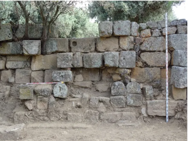
Hispania-The material remains of episcopal Egitania and the Visigothic city are still fragmentary, hindering positive conclusions. However, the comparative re-evaluation, by the project IGAEDIS, of the results of previous archaeological excavations of Egitania with that of new ones is enabling a better understanding of the contrasts of the Roman landscape with the Suevic-Visigothic. During the latter, the defining structure of the city was likely its wall, built mostly with Roman materials reused along 753 meters (2,470.47 feet) to cover an urban enclosure smaller than the previous Roman core (fig. 3).15 A series of structures that have been identified, since their discovery in the 1950s, with the remains of a Visigothic episcopal palace, are situated between the wall and the current Sé de Idanha-a-Velha, and referred to as the Paço dos Bispos.16 Recently, a new hypothesis rejects this theory and there remains a reluctance among the research community to accept this thesis on the basis of the difficulty of explaining these remains in a single stratigraphic and chronological plane.17
The historiographical discussion on the material remains of Egitania has been particularly intense in relation to the current Sé de Idanha-a-Velha (fig. 4), identified since the time of its excavation, in the mid-twentieth century, with the remains of the Spania. El Ars Gromatica Gisemundi y la Discriptio Hispaniae: actividades agrimensorias en época
romana y bizantina,” Gerion 34 (2016): 361-62. This same canon references the claim of the Egitanian bishop, Sclua, concerning the return of part of his territorial jurisdiction, which had been assigned before to the bishopric of Salmantica as compensation for the removal of part of its region by the Suevic Church (Díaz, “Propiedad y poder,” 55).
15 José Cristóvão, “Breve estudo sobre a organização do espaço público e os equipamentos urbanos da
cidade de Idanha-a-Velha (dos finais do século I a.C. ao limiar do século IV),” in Actas das 2as
Jornadas de Património da Beira Interior: Lusitanos e Romanos no Nordeste da Lusitânia (Guarda,
2005), 202. The renovation of the early imperial house of Quintal do Lagar by the urban wall allows us to set as a working hypothesis its construction between the end of the third century and the beginning of the fourth. Other theories suggest different chronologies and point out, in addition, the restoration and remodeling of works along Visigothic, Andalusian or Templar times, although the lack of precise stratigraphy prevents consensus.
16 Fernando de Almeida, “Um ‘palatium episcopi’ do século VI em Idanha-a-Velha (Portugal),” in IX Congreso Nacional de Arqueología (Valladolid, 1966), 408-11.
17 See Isabel Sánchez Ramos and Jorge Morín de Pablos, Idanha-a-Velha. Portugal. El espiscopio de Egitania en época tardoantigüa (Madrid, 2014), 73-79.
Visigothic cathedral.18 The basilica building, with an east-oriented apse, contains a complex architecture with two different building techniques: 1) ashlar, coming from the spolia of Roman materials in socket, apse and interior arches, and 2) rough ashlar, in the rest of the building.19 In the south front of the Sé a cruciform baptismal pool was also found.20 This baptistery is perceived as part of a larger architectural complex that terminated at the east end with a quadrangular stay with an opus signinum paving floor (fig. 5). This is a building that should quite certainly be identified as part of a second basilica built after the renovation of the possible church associated with the baptismal pool mentioned above. However, another theory includes the baptistery inside a cathedral connected with a domus episcopalis identified in the current Sé de Idanha-a-Velha.21
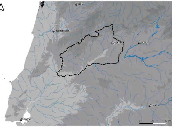
The Territory of Egitania in the Center of Lusitania
The delimitation of the ager igaeditaniensis between the end of the first century BC
and the beginning of the first century AD would probably follow the course of the
rivers Meimoa (between the Gardunha and Malcata), Erjas, Tagus and Zêzere. This circumscription could have been sustained without major modifications during both Roman and early medieval periods, as some references about Egitania point to, for example, the provincial council of Mérida, the work of the Andalusian historian
18 Fernando de Almeida, Egitânia. História e Arqueologia (Lisbon: Universidade de Lisboa, 1956),
94-108.
19 Cristovão, A aldeia histórica de Idanha-a-Velha. Guia para uma visita, 14-19.
20 Fernando de Almeida, “O baptistério paleocristão de Idanha–a–Velha (Portugal),” Boletín del Seminário de Estúdios de Arte y Arqueologia XXXI (1965): 134-36.
21 Sánchez Ramos and Morín de Pablos, Idanha-a-Velha. Portugal. El espiscopio de Egitania en época tardoantigüa, 70-73 & 84-89. Other hypotheses for the nature of this building include: 1) a mosque
related to the activity of the rebel Muladi Ibn Marwan in the ninth century (Cláudio Torres, “A Sé Catedral da Idanha,” Arqueologia Medieval 1 [1992]: 169-78); 2) a Mozarabic basilica of hybrid character due to the Islamic influence raised in a border context (Manuel Luis Real, “Inovação e resistência: dados recentes sobre a Antiguidade Cristã no Ocidente Peninsular,” in IV Reunião de
Arqueologia Cristã Hispânica [Barcelona, 1995], 17-68); 3) a mosque-cathedral (Paulo Fernandes, A Mesquita-Catedral de Idanha-a-Velha [Lisbon, 2001]); or 4) a palatial building refurbished later as a
mosque and church (Luis Caballero Zoreda, “Aportaciones de la lectura de paramentos a la polémica sobre la Sé de Idanha-a-Velha,” in Al-Ândalus. Espaço de mudanza. Balanço de 25 años de história e
arqueologia medievais. Seminario Internacional, Homenagem a Juan Zozaya Stabel-Hansen [Mértola,
Razi or the donation made by the Portuguese King Afonso Henriques to the Order of Temple in 1165.22 As such, Egitanian territorial administrations between the fourth and eighth centuries would have controlled the area between the dioceses of Cauria,
Emerita, Pax Iulia, Olisippo, Conimbriga and Caliabria, occupying, therefore, a
central space within Lusitania, in the peninsular southwest (fig. 6).23
The settlement of Egitanian territory during the Roman period is articulated by the road network and the small urban cores of this peninsular area. Most of the identified establishments provide little material and should be regarded as small livestock settlements; villae are hardly documented. In addition, the considerable presence of
vici in this space, taken as sites favored by Rome as a means of territorial
arrangement, is one of the main features of the settlement in this region.24 On the other hand, the important auriferous documented areas, especially along the Tagus river and some of its affluents, would determine the emergence of an important network of mining settlements.25
22 See Cordero Ruiz, “La organización de la diocesis Egitaniensis y la configuración territorial del
interior de Lusitania durante la Alta Edad Media (400-800).”
23 Maria João Ângelo and Carla Alegria Ribeiro, “Torre dos Namorados (Quintas da Torre, Fundão).
Historiografia e Perspectivas de Investigação,” in Actas das I Jornadas de Beira Interior. História e
Património, ed. Maria do Céu Crespo Ferreira, S. Perestrelo, Marcos Osório and A. Marques (Guarda:
Câmara Municipal de Guarda, 2000), 112-44; Marcos Osório, O Povoarnento Romano do Alto Côa (Guarda, 2006); Elisa Albuquerque and Constança Guimarães dos Santos, “Capela de São Pedro da Capinha (Fundão): primeira intervenção,” Al-Madam online. Serie II 15 (2007): 1-7; Pedro C. Carvalho, “O final do mundo romano: (des)continuidades e/ou (in)visibilidade do registo nas paisagens rurais do interior norte da Lusitania,” in A Lusitânia entre romanos e bárbaros, ed. José d’Encarnação, Maria da Conceição Lopes and Pedro C. Carvalho (Coimbra, 2016), 397-436.
24 Luís da Silva Fernandes, María do Céu Ferreira, Marcos Osório and Manuel Perestrelo, “Vicus e Castellum na Provincia Lusitania: notas epigráficas e arqueológicas,” Conimbriga XLV (2006):
165-98; Pedro C. Carvalho, “Pela Beira Interior no século I d.C.: das capitais de civitates aos vici, entre o Pônsul e a Estrela,” in Actas V Congresso de Arqueologia do Interior Norte e Centro de Portugal (Mêda-Foz Côa, 2011), 313-30.
25 Francisco Henriques, Carlos Batata, Mário Chambino, João Carlos Caninas and Pedro Cunha,
“Mineração aurífera antiga, a céu aberto, no centro e sul do distrito de Castelo Branco,” in VI Simpósio
sobre Mineração e Metalurgia históricas no Sudoeste Europeu, ed. Carlos Batata (Abrantes, 2011),
2-29; Francisco Sánchez-Palencia Ramos, Alejandro Beltrán Ortega, Damián Romero Perona, Brais X. Currás Refojos, Guillermo Reher Díez and I. Sastre Prats, “Zonas mineras y civitates del noreste de Portugal en el Alto Imperio (zona fronteriza con España de los distritos de Braganza y Castelo Branco),” Informes y Trabajos 9 (2012): 606-27.
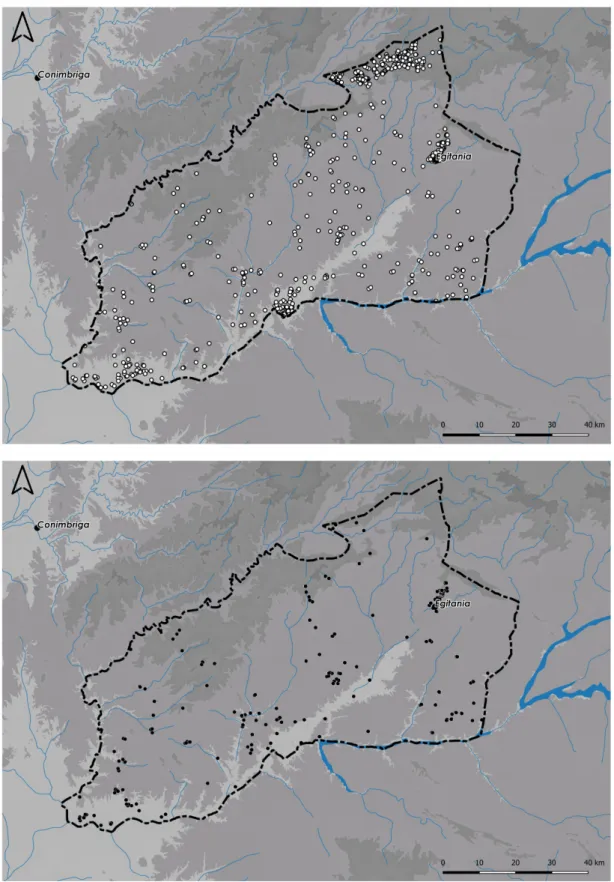
This pattern of occupation changed drastically between the fourth and fifth centuries; the lack of details of the transformation makes it rather impossible to analyze the different historical processes associated with this change. However, it is possible to observe the abandonment during these two centuries of many of the Roman settlements, in addition to a significant reduction in the number of known settlements overall.26 This last aspect is particularly crucial in the case of Egitania, where, after the study of 510 archaeological sites of Roman and medieval chronology only a 15.8% can be situated in the second period (fig. 7).
This reduction should not be associated with either the longstanding general crisis in Egitania’s rural hinterlands or with the arrival of Germanic tribes in the first half of the fifth century. As with the urban landscape, the causes of this development remain to be discovered by means of specific prospecting and excavation work. On the other hand, it is possible to point out the maintenance of occupation patterns established in Roman times. In this sense, this situation may be associated with documented continuity in sites such as the Roman villa Dos Barros, with a residual occupation of peasant character between the fifth and sixth centuries, the site of Torre dos Namorados, a large Roman settlement (pagus?/vicus?) inhabited until the Middle Ages, or the Capela de São Pedro of Capinha, whose occupation stretches between the seventh and ninth centuries.27 Thus it would appear, as in the case of the territory of Emerita, that these changes could be related to a concentration of occupation patterns and ownership of the land.28
26 Carvalho, “O final do mundo romano: (des)continuidades e/ou (in)visibilidade do registo nas
paisagens rurais do interior norte da Lusitania,” 401-06.
27 Rui Carvalho and Madalena Costa Cabral, “A villa romana dos Barros - Oledo. Primeira notícia,” Portvgalia. Nova Serie XV (1994): 74; Ângelo and Alegria Ribeiro, “Torre dos Namorados (Quintas
da Torre, Fundão). Historiografia e Perspectivas de Investigação”; Albuquerque and Guimarães dos Santos, “Capela de São Pedro da Capinha (Fundão): primeira intervenção.”
The transformations could also be the result of the consolidation of Egitania as episcopal see, and with its strategic location in the southeast area of the Suevic Kingdom,29 although its border position between the Suevic and Visigothic kingdoms might not have led to a defined limit. That said, the split between the two kingdoms could have been characterized by the existence of a confinium between two analogous entities.30 Recent archaeological research on the space between the cities of Emerita and Asturica has documented fortified archeological sites whose origin, reoccupation or destruction seem to be in relation to this border. However, these should not be imagined as Suevic or Visigothic border sites, but rather as the residences of local populations aligned with one power or the other.31
In the territory of Egitania, the sites of Monsanto and Penha Garcia could be considered during this period as fortified sites. The information available on these sites is still too limited for definitive conclusions as to their full function, although the Visigothic tremisses discovered suggest them as local places of elite residence, establishments that would reach a great vitality as the influence of the ancient Roman
civitates declined.32
The Parrochiale Suevum provides valuable information on the territorial configuration of the bishopric of Egitania, which would have two parishes called
29 Lauwers and Ripart, “Représentation et gestion de l’espace dans l’Occident medieval,” 6-11.
However, this last situation might not imply an increase in the authority of the Suevic monarchy, which would act as a point of authority in a scenario dominated by the local elites, an unsurprising situation in the western peninsular and European framework from the fifth century on.
30 Martin, La géographie du pouvoir dans l'Espagne visigothique, 293.
31 Pablo Díaz and Enrique Ariño, “La frontera suevo-visigoda. Ensayo de lectura de un territorio en
disputa,” in Fortificaciones en la Tardoantigüedad, ed. Raúl Catalán, Patricia Fuentes and José Carlos Sastre (Madrid, 2014), 185-90; Iñaki Martín Viso, “Tremisses y potentes en el Nordeste de Lusitania (siglos VI-VII),” Mélanges de la Casa de Velázquez 38 (2008): 175-200; Catarina Tente and Iñaki Martín Viso, “O Castro do Tintinolho (Guarda, Portugal). Interpretação dos dados arqueológicos como fortificação do período pós-romano,” in Los Castillos Altomedievales en el Noroeste de la Península
Ibérica, ed. Juan Antonio Quirós and Sebastián Tejado (Vitoria: Universidad del País Vasco, 2012),
57-75.
Monecipio and Francos, a church with a territory and a congregation attached.33 The first location has the peculiar distinction of having been a mint of the Visigothic kings Reccared, Witteric and Sisebut.34 This conclusion opens up the possibility of assigning to this parish the status of municipium and civitas capital, although there is no consensus on this point.35 The second, also with an undetermined location, has been associated, on an ethnonymic basis, with the establishment of a Frankish group in the area, although material evidence does not yet support this thesis.36 These identification problems also extend to the rest of the Christian interior of Lusitania, although in the case of Egitania they are especially significant and represent an ‘invisibility’ that only allows only a theorizing about the location of rural basilicas in the sites of São Pedro de Capinha and Granja de São Pedro.37
Finally, reference to the auriferous character of the Tagus river in the works of authors such as Jordanes, Boethius or Isidore of Seville, along with the plenty of mints – Lameco, Eminio, Veseo, Totela, Coleia, Caliabria, Salmantica, Monecipio, and Egitania – and tremisses in this area could indicate an extension in time and, to a smaller scale, in mining activities and the settlement associated with these in the aforementioned areas (fig. 8).38
33 David, Études historiques sur la Galice et le Portugal du Vie au XII siècle; Gisela Ripoll and Isabel
Velázquez, “Origen y desarrollo de las parrochiae en la Hispania de la Antigüedad Tardía,” in Alle
origini della parrochia rurale (IV-VIII sec.), ed. Philippe Pergola (Vatican City, 1999), 120-21. 34 Jorge de Alarcão, “Notas de arqueologia, epigrafia e toponímia – VI,” Revista Portuguesa de Arqueologia 15 (2012): 121; Ruth Pliego Vázquez, La moneda visigoda. Historia monetaria del reino visigodo de Toledo (c. 569-711) (Seville, 2009), 126-27.
35 Jorge de Alarcão, “As paróquias suévicas do território actualmente portugués,” in Religión, lengua y cultura prerromanas de Hispania, ed. Francisco Villar and María Pilar Fernández Álvarez (Salamanca:
Universidad de Salamanca, 2001), 53; José Antonio Correa, “El latín de las monedas visigodas,” in
Latin vulgaire-latin tardif VII, ed. Carmen Arias (Seville, 2006), 230.
36 Alarcão, “As paróquias suévicas do território actualmente portugués,” 54; Luís A. García Moreno,
“La iglesia y el cristianismo en la Galecia de época sueva,” Antigüedad y Cristianismo XXIII (2006): 42.
37 Joáo Inês Vaz, “A arquitectura paleocristã da Lusitânia Norte,” Mathesis 20 (2011): 90-128; M. C.
Santos and Elisa Albuquerque, “Capela de S. Pedro da Capinha,” Eburobriga 5 (2008): 97-108.
38 Pliego Vázquez, La moneda visigoda, 125-28; Martín Viso, “Tremisses y potentes en el Nordeste de
Conclusions
The beginning of the fragmentation process and restructuring of the urban system and the rural settlement in the interior of Lusitania can be dated between the fourth to fifth centuries. At this time, the transformation of the Roman model is characterized by the dramatic reduction in the number of known settlements and the dismantling of the old urban cores. This development would be defined, as in other parts of western Europe, by the consolidation of an asymmetric framework whereby the fragmentation of territorial structure led each settlement to operate as the center of its own jurisdiction. However, the new situation did not mean the total disappearance of the ancient Roman administration which survived, to greater or lesser extent, in the cities of this period, especially in those which would reach the rank of episcopal see. Subsequently, a new system of linked countryside-city defined by its diversity and the fragmentation of territorial jurisdictions developed, although on them overlapped the political, social, economic and cultural structure controlled by the Church and, then, the Suevic and Visigothic kingdoms.
The elevation of Egitania to episcopal see within the Suevic Kingdom meant the recognition of its Christian community and the importance of the city, which would reach a position of authority within the new geopolitical structure of the sixth century and forward. Nevertheless, the available sources for evidence of the Egitanian urban landscape during the Suevic-Visigothic period, especially archaeological sites, are still scarce. Additionally, there remain significant questions within an intense historiographic discussion regarding the wall, the Paco dos Bispos and Sé de Idanha-a-Velha.
Our understanding, then, of the territory of Egitania, indissoluble and complementary to the urban reality, remains an open question. However, it seems plausible that there was, during the Suevic-Visigothic period, a significant reduction in the number of rural settlements, framing the remaining ones within a definite settlement pattern, roughly, by the maintenance of the ancient Roman model. This situation was probably related to the concentration of the occupation and land ownership patterns. This territory would connect, at least in part, through the parishes of Monecipio and Francos, whose precise locations are unknown. Unfortunately, the extant records do not yet afford a comprehensive understanding of the Christianization of the surrounding rural landscape, of the location of the rural basilicas associated with the bishopric of Egitania, or of the reason why some Visigothic kings coined currency in Monecipio, which could have been linked to a possible continuity, on a smaller scale, of the gold mining in this area. Finally, the emergence of fortified sites, defined by the documentation therein of Visigothic tremisses, indicates the local elites’ place of residence. These residences, these cases of specific land ownership, were potentially used by the elite, as with their urban residences, to exert power through the establishment of personal ties.
List of figures
Figure 2: Baptistery located north of the Sé of Idanha-a-Velha (Cristovão, A aldeia
Figure 5: Baptistery located south of the Sé of Idanha-a-Velha (Cristovão, A aldeia
Figure 7: Maps of the distribution of rural settlement in the territory of Egitania during the Roman (top) and early medieval periods (bottom).
Bibliography
Primary
Concilios visigóticos e hispano-romanos. Edited by José Vives, Tomás Marín
Martínez, Gonzalo Martínez Díez. Barcelona, Madrid: CSIC, 1963.
Secondary
Alarcão, Jorge de. “As paróquias suévicas do território actualmente portugués.” In
Religión, lengua y cultura prerromanas de Hispania, edited by Francisco Villar and
María Pilar Fernández Álvarez, 25-59. Salamanca: Universidad de Salamanca, 2001. Alarcão, Jorge de. “Notas de arqueologia, epigrafia e toponímia – VI.” Revista
Portuguesa de Arqueologia 15 (2012): 117-18.
Albuquerque, Elisa and Constança Guimarães dos Santos. “Capela de São Pedro da Capinha (Fundão): primeira intervenção.” Al-Madam online. Serie II 15 (2007): 1-7. Almeida, Fernando de. Egitânia. História e Arqueologia. Lisbon: Universidade de Lisboa, 1956.
Almeida, Fernando de. “O baptistério paleocristão de Idanha–a–Velha (Portugal).”
Boletín del Seminário de Estúdios de Arte y Arqueologia XXXI (1965): 134-36.
Almeida, Fernando de. “Um ‘palatium episcopi’ do século VI em Idanha-a-Velha (Portugal).” In IX Congreso Nacional de Arqueología, 408-11. Valladolid, 1966. Ângelo, Maria João and Carla Alegria Ribeiro. “Torre dos Namorados (Quintas da Torre, Fundão). Historiografia e Perspectivas de Investigação.” In Actas das I
Jornadas de Beira Interior. História e Património, edited by Maria do Céu Crespo
Ferreira, S. Perestrelo, M. Osorio and A. Marques, 112-44. Guarda: Câmara Municipal de Guarda, 2000.
Caballero Zoreda, Luis. “Aportaciones de la lectura de paramentos a la polémica sobre la Sé de Idanha-a-Velha.” In Al-Ândalus. Espaço de mudanza. Balanço de 25
años de história e arqueologia medievais. Seminario Internacional, Homenagem a Juan Zozaya Stabel-Hansen, 266-73. Mértola, 2006.
Castillo Pascual, María José. Espacio en orden: El modelo gromático-romano de
ordenación del territorio. Logroño, 2011.
Carvalho, Pedro C. “Pela Beira Interior no século I d.C.: das capitais de civitates aos vici, entre o Pônsul e a Estrela.” In Actas V Congresso de Arqueologia do Interior
Norte e Centro de Portugal, 313-30. Mêda-Foz Côa, 2011.
Carvalho, Pedro C. “O final do mundo romano: (des)continuidades e/ou (in)visibilidade do registo nas paisagens rurais do interior norte da Lusitania.” In A
Lusitânia entre romanos e bárbaros, edited by José d’Encarnação, Maria da
Conceição Lopes and Pedro C. Carvalho, 397-436. Coimbra, 2016.
Carvalho, Rui and Madalena Costa Cabral. “A villa romana dos Barros - Oledo. Primeira notícia.” Portvgalia. Nova Serie XV (1994): 61-82.
Cordero Ruiz, Tomás. El territorio emeritense durante la Antigüedad Tardía (siglos
IV-VIII). Génesis y evolución del mundo rural lusitano. Madrid, 2013.
Cordero Ruiz, Tomás. “La organización de la diocesis Egitaniensis y la configuración territorial del interior de Lusitania durante la Alta Edad Media (400-800).” In press. Cordero Ruiz, Tomás and Bruno Franco Moreno. “La desaparición, desarticulación y transformación de la red urbana en la Frontera Inferior de al-Andalus durante el período omeya.” In press.
Correa, José Antonio. “El latín de las monedas visigodas.” In Latin vulgaire-latin
tardif VII, edited by Carmen Arias, 219-42. Seville, 2006.
Cristóvão, José. A aldeia histórica de a-Velha. Guia para uma visita. Idanha-a-Nova, 2002.
Cristóvão, José. “Breve estudo sobre a organização do espaço público e os equipamentos urbanos da cidade de Idanha-a-Velha (dos finais do século I a.C. ao limiar do século IV).” In Actas das 2as Jornadas de Património da Beira Interior:
Lusitanos e Romanos no Nordeste da Lusitânia, 189-204. Guarda, 2005.
David, Pierre. Études historiques sur la Galice et le Portugal du VIe au XII siècle. Paris, 1947.
De Man, Adrian. Defensas urbanas tardías de Lusitânia. Mérida, 2011.
Díaz, Pablo. “Propiedad y poder: la iglesia lusitana en el siglo VII.” In Los últimos
romanos en Lusitania, edited by Agustín Velázquez, Enrique Cerrillo and Pedro
Mateos, 53-72. Mérida, 1995.
Díaz, Pablo. El reino suevo (411-585). Madrid, 2011.
Díaz, Pablo and Enrique Ariño. “La frontera suevo-visigoda. Ensayo de lectura de un territorio en disputa.” In Fortificaciones en la Tardoantigüedad, edited by Raúl Catalán, Patricia Fuentes and José Carlos Sastre, 179-90. Madrid, 2014.
Fernandes, Paulo. A Mesquita-Catedral de Idanha-a-Velha. Lisbon, 2001.
Fernandes, Luís da Silva, María do Céu Ferreira, Marcos Osório and Manuel Perestrelo. “Vicus e Castellum na Provincia Lusitania: notas epigráficas e arqueológicas.” Conimbriga XLV (2006): 165-98.
Fixot, Michel. “La cité et son territoire: l’exemple du Sud-Est de la Gaule.” In Towns
and their Territories Between Late Antiquity and the Early Middle Ages, edited by
Gian Pietro Brogiolo, Paul Gauthier and Neil Christie, 37-62. Leiden, 2000.
García Moreno, Luís A. “La iglesia y el cristianismo en la Galecia de época sueva.”
Antigüedad y Cristianismo XXIII (2006): 39-55.
Henriques, Francisco, Carlos Batata, Mário Chambino, João Carlos Caninas and Pedro Cunha. “Mineração aurífera antiga, a céu aberto, no centro e sul do distrito de
Castelo Branco.” In VI Simpósio sobre Mineração e Metalurgia históricas no
Sudoeste Europeu, edited by Carlos Batata, 2-29. Abrantes, 2011.
Lauwers, Michel. “Territorium non facere diocesim. Conflits, limites et représentation territoriale du diocèse, Ve-XIIIe siècle.” In L’espace du diocèse. Genèse d’un
territoire dans l’Occident médiéval (Ve-XIIIe siècle), edited by Florian Mazel, 23-65.
Rennes: Presses Universitaires de Rennes, 2008.
Lauwers, Michel and Laurent Ripart. “Représentation et gestion de l’espace dans l’Occident medieval.” In Rome et l’Etat moderne européen, edited by Jean-Philippe Genêt, 115-71. Rome: École française de Rome, 2007.
Martin, Céline. La géographie du pouvoir dans l'Espagne visigothique. Villeneuved’Ascq, 2003.
Martín Viso, Iñaki. “Tremisses y potentes en el Nordeste de Lusitania (siglos VI-VII).” Mélanges de la Casa de Velázquez 38 (2008): 175-200.
Olesti, Oriol and Ricard Andreu. “Una nueva fuente documental sobre
Hispania-Spania. El Ars Gromatica Gisemundi y la Discriptio Hispaniae: actividades
agrimensorias en época romana y bizantina.” Gerion 34 (2016): 351-81. Osório, Marcos. O Povoarnento Romano do Alto Côa. Guarda, 2006.
Pliego Vázquez, Ruth. La moneda visigoda. Historia monetaria del reino visigodo de
Toledo (c. 569-711). Seville, 2009.
Real, Manuel Luis. “Inovação e resistência: dados recentes sobre a Antiguidade Cristã no Ocidente Peninsular.” In IV Reunião de Arqueologia Cristã Hispânica, 17-68. Barcelona, 1995.
Ripoll, Gisela and Isabel Velázquez. “Origen y desarrollo de las parrochiae en la
Hispania de la Antigüedad Tardía.” In Alle origini della parrochia rurale (IV-VIII sec.), edited by Philippe Pergola, 101-65. Vatican City, 1999.
Sánchez-Palencia Ramos, Francisco, Alejandro Beltrán Ortega, Damián Romero Perona, Brais X. Currás Refojos, Guillermo Reher Díez and I. Sastre Prats. “Zonas mineras y civitates del noreste de Portugal en el Alto Imperio (zona fronteriza con España de los distritos de Braganza y Castelo Branco).” Informes y Trabajos 9 (2012): 606-27.
Sánchez Ramos, Isabel and Jorge Morín de Pablos. Idanha-a-Velha. Portugal. El
espiscopio de Egitania en época tardoantigüa. Madrid, 2014.
Santos, M. C. and Elisa Albuquerque. “Capela de S. Pedro da Capinha.” Eburobriga 5 (2008): 97-108.
Tente, Catarina and Iñaki Martín Viso. “O Castro do Tintinolho (Guarda, Portugal). Interpretação dos dados arqueológicos como fortificação do período pós-romano.” In
Los Castillos Altomedievales en el Noroeste de la Península Ibérica, edited by Juan
Antonio Quirós and Sebastián Tejado, 57-75. Vitoria: Universidad del País Vasco, 2012.
Torres, Cláudio. “A Sé Catedral da Idanha.” Arqueologia Medieval 1 (1992): 169-78. Vaz, Joáo Inês. “A arquitectura paleocristã da Lusitânia Norte.” Mathesis 20 (2011): 90-128.
Wickham, Chris. “Un pas ver le Moyen Âge? Permanences et mutations.” In Les
campagnes de la Gaule à la fin de l'Antiquité, edited by Pierre Ouzoulias, Christophe
Pellecuer, Claude Raynaud, P. Van Ossel and P. Garmy, 555-67. Antibes, 2001. Wickham, Chris. Una nueva historia de la Alta Edad Media. Europa y el mundo
mediterráneo. Madrid: Edición Destacada, 2008.