Vol.50, n. 5 : pp. 905-912 September 2007
ISSN 1516-8913 Printed in Brazil BRAZILIAN ARCHIVES OF BIOLOGY AND TECHNOLOGY
A N I N T E R N A T I O N A L J O U R N A L
Water Balance in Karst: Case Study of the Ribeirão da
Onça Catchment in Colombo City, Paraná State - Brazil
Leandro Redin Vestena1* and Masato Kobiyama2
1
Departamento de Geografia; CEDETEG; Universidade Estadual do Centro-Oeste; C.P. 3010; 85040-080; Guarapuava - PR - Brasil. 2Departamento de Engenharia Sanitária e Ambiental; Universidade Federal de Santa Catarina; C.P. 476; 88010-970; Florianópolis - SC - Brasil.
ABSTRACT
With the objective to analyze the hydrological processes and the water balance, a simplified water balance method and the modified Penman formula were applied to the Ribeirão da Onça river catchment in Colombo city, Paraná State. For the analysis, the data obtained during the monitoring period from 1997 to 2000 were utilized. The results showed that the values of the real evapotranspiration estimated by the method of the simplified water balance were negative for the certain periods and for other period sometimes more than those of the potential evapotranspiration estimated by the modified Penman formula. It implied the existence of significant groundwater recharge from other catchments to the study area, and indicates that the simplified water balance method was not suitable for the hydrological study of this karst catchment. The value of the groundwater recharge received by this catchment was estimated as 554 mm/year for the analysis period.
Keys word: Water balance; evapotranspiration; karst
* Author for correspondence
INTRODUCTION
The population of the Curitiba Metropolitan Region (CMR) is approximately over 2.7 millions presently. COMEC (1997) pointed out a deficit of water supply to the CMR between 10 and 25%. This region has been suffering from the continuous water-rationings performed by the SANEPAR (Paraná Sanitary Company) and consequently from the lack of water. The water supply to the CMR is the most important challenge. According to Andreoli et al. (1999), the water resources would be exhausted in 2030. The water demand in the CMR has been increasing due to the population and industry explosion, and the increase of water consumption per capita. Because of a high water quality, the low exploration cost
and the difficulty of settlement of a conventional sanitation infrastructure on steep areas, the SANEPAR started to explore the groundwater in the karst without detailed hydrogeological and environmental impacts studies.
The better understanding of the water dynamics of the Ribeirão da Onça catchment makes it possible to encounter solutions for the existent divergences of water multipurpose-uses.
The objective of the present study was to analyze the hydrological processes, to model and to evaluate the water balance of the catchment. A simple water balance method and the modified Penman method were used to estimate the real evapotranspiration (ETR) and the potential evapotranspiration (ETP), respectively.
MATERIAL AND METHODS
The delimitation of the study catchment was done and the exit of the catchment is defined as the locality of the Montante da Ponte discharge monitoring station (Code: 81290500) which is 4
km upper stream to the mouth of the Ribeirão da Onça River. This station has been operated by the SUDERHSA (Superintendence of Water Resources Development and Environmental Sanitation) since the end of 1997. The catchment is located in the northeast of the Colombo City, between the S25º15'00" and S25º17'30" and between W49º09'00" and W49º13'00". Its area is of 16.118 km2 (Fig. 1). According to IAPAR
(1994), the climate of the area is the Cfb (subtropical humid mesothermic) type in the Köppen classification. It means temperate climate with fresh summers where the mean temperature of the hottest month is below 22ºC, without defined dry winter, with the occurrence of severe and frequent frosts, and with the mean temperature of the coldest month below 18ºC.
Figure 1 - Location of the study area
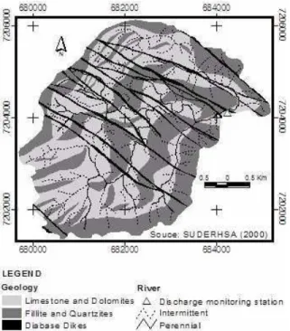
The land-use in this catchment is characterized with small-size agriculture like vegetable garden (41%). The presence of vegetation cover is expressive (the forest covers 31% of the total land and the bush 21%), meanwhile the residential and commercial areas represent only 7% (Vestena, 2002). The study area has a complex geology where permeable rocks (limestones) are surrounded by impermeable rocks (fillite, quartzites and diabase dikes) (Fig. 2). The
intercross of two crests composed of diabase dikes with two crests of quartzite-filite composition forms individual unitary compartments (Figure 3), which causes flow conditions to be differentiated and independent (Lisboa, 1997).
constitute high topography and insert the dolomites (Marini et al., 1967). In the limestones the topography is lowered and shows very characteristic karst forms like dolines, drains,
uvalas and caves. The dissolution processes act more intensively in the limestones, generating the differential erosion.
Figure 2 - Geology of the study area
Figure 3 - Three-dimensional model representing the unitary compartments
In order to estimate the values of ETP and ETR, to evaluate the hydrological processes and to establish the water balance of the Ribeirão da Onça River catchment, the following data were
and wind speed at the Piraquara meteorological station (Code: 2549041) and daily discharge at Montante da Ponte discharge station (Code: 81290500). All of the data were obtained during the period from 1997 to 2000.
The Penman method modified by Doorenbos and Pruit (1977) was used to calculate the daily values of ETP. According to Müller (1995) and Oliveira (1999), the modified Penman method was the best one to estimate ETP, in the Paraná State. The simple water balance method was used to estimate ETR and the groundwater flow.
In the modified Penman method, the ETP can be estimated with the following equation:
ETP = C[W · Rn + (1-W)·ƒ(u)·(ea – ed)] (1)
Radiation Aerodynamic component component
where ETP is the potential evapotranspiration (mm/day); C is the correction factor to compensate the day and night effect under climatic conditions, and relates the solar radiation, the maximum relative humidity and the day and night wind speed (dimensionless); W is the weighing factor related with the temperature and the altitude (dimensionless); Rn is the liquid radiation
(mm/day); f(u) is the function related with the wind (dimensionless); ea is the water vapor
saturation pressure (mbar); ed is the real saturation
pressure of the vapor in the air (mbar). In the simple water balance method, the value of ETR was equal to the precipitation (input) minus
the runoff at the mouth (output) minus the water quantity captured at the wells inside the catchment (output).
Monthly ETR was also calculated multiplying monthly ETP with the monthly coefficient of correlation of reference (K). Müller (1995) calculated the historical monthly averages of the potential evapotranspiration (HETP) and the real evapotranspiration (HETR) by the modified Penman method and the CRAE (Complementary
Relationship Areal) method proposed by Morton
(1983), respectively. In the present study, these values of HETP and HETR were used to calculate the monthly values of K (Table 1).
Considering the water balance concept and using the value of ETR for each month, the equation (2) was established to quantify the groundwater flow.
P S P ETR Q Q
Q = − − −
or QS =P−ETP⋅K−Q−QP
or S Q QP
HETR HETP ETP
P
Q = − ⋅ − − (2)
where QS is the groundwater flow that enters into (+) or that leaves (-) the catchment (mm/month); P is the precipitation (mm/month); ETR is the real evapotranspiration (mm/month); Q is the runoff (mm/month); and QP is the captured water at the wells (mm/month).
Table 1 – Coefficients of correlation between historical monthly averages of HETR (CRAE) and HETP (Penman) of the meteorological station of Piraquara (code: 2549041), for the period of February of 1970 to October of 1992
Month HETP (Penman)* (mm) HETR (CRAE)* (mm) K (HETR/HETP)
January 124 131 1.056
February 97 112 1.155
March 90 103 1.144
April 66 73 1.106
May 48 52 1.083
June 39 38 0.974
July 45 38 0.844
August 58 54 0.931
September 70 71 1.014
October 94 101 1.074
November 107 117 1.093
December 115 126 1.096
Annual 953 1016 1.066
RESULTS AND DISCUSSION
In the hydrographs obtained during the period for the analysis, small variations of the water quantity captured by SANEPAR were found, especially in 1998 (Fig. 4).
In the case that only precipitation, runoff and captured water quantity were used as the variables in the simple water balance method, the ETR values were negative, which allowed to infer that other variables influenced the water balance in the Ribeirão da Onça catchment. Thus, it was thought that this catchment received water from outside of the catchment divisons. The catchment might have groundwater recharge areas that extrapolated the topographic divisons. It meant that the topographic divisors did not coincide with the phreatic ones. This fact strongly influenced the hydrological cycle in this catchment.
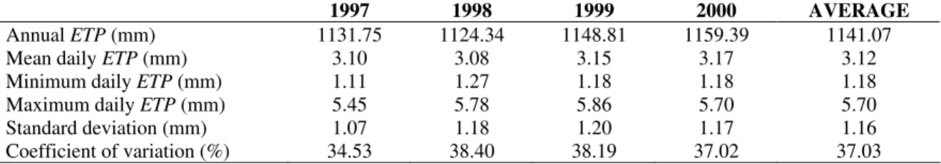
The mean annual value of ETP for the period from 1997 to 2000, obtained with the modified Penman method, was 1141 mm (= 3.12 mm/day). The minimum and maximum of the daily ETP were 1.11 mm and 5.86 mm, respectively. The standard deviation of the daily ETP for each year was between 1.07 mm and 1.20 mm, and the
coefficient of variation between 34.5 and 38.4% (Table 2).
The ETP was larger in the summer (November, December and January) than in the winter (June, July and August). It confirmed that the temperature exercises significant influence on the ETP. The maximum and minimum extremes were observed in the summer and in the winter, respectively (Fig. 5).
The values of the monthly ETR obtained from the multiplication of ETP (Penman) estimated for each month with K were larger in November, December, January and February and smaller in July and June. The annual ETR was 1221 mm and its behavior was similar to that of the ETP during the year (Table 3). The mean annual precipitation for the period from 1997 to 2000 was 1594 mm. There was more rain in January and September and less in May. The runoff was larger in September and October and the smallest in May. The Fig. 6 shows the correlations (a) between the runoff and precipitation and (b) between the runoff and captured water quantity. The former was very small and positive, and the latter was negative. When the runoff was larger than 25 mm/month, the water quantity captured at the wells decreased abruptly and kept constant.
0 5 10 15 20 25 30
1 21 41 61 81 101 121 141 161 181 201 221 241 261 281 301 321 341 361
Time (day) Fl ow ( m m /da y ) 0 20 40 60 80 100 120 140 160 Pr e c ip it a tio n ( m m /d a y ) Runoff
Captured Water Quantity Precipitation
Table 2 –ETP characteristics of the Ribeirão da Onça river catchment for the period from 1997 to 2000
1997 1998 1999 2000 AVERAGE
Annual ETP (mm) 1131.75 1124.34 1148.81 1159.39 1141.07
Mean daily ETP (mm) 3.10 3.08 3.15 3.17 3.12
Minimum daily ETP (mm) 1.11 1.27 1.18 1.18 1.18
Maximum daily ETP (mm) 5.45 5.78 5.86 5.70 5.70
Standard deviation (mm) 1.07 1.18 1.20 1.17 1.16
Coefficient of variation (%) 34.53 38.40 38.19 37.02 37.03
-1,0 2,0 3,0 4,0 5,0 6,0
1 21 41 61 81 101 121 141 161 181 201 221 241 261 281 301 321 341 361
Day of the year
ET
P (
m
m
/d
a
y
)
Figure 5 - Mean daily ETP (mm) estimated with the modified Penman method for the period from 1997 to 2000
Table 3 – Mean monthly ETR (mm), precipitation (mm), runoff and water quantity captured at the wells by SANEPAR in the Ribeirão da Onça river catchment during the period of 1997 - 2000
Month ETR (mm) Precipitation (mm) Water Quantity
Captured (mm)* Runoff (mm)**
January 147 217 41 38
February 135 171 52 41
March 126 133 33 48
April 93 64 26 42
May 65 50 25 32
June 46 123 25 38
July 45 115 36 48
August 68 92 26 40
September 85 203 26 65
October 117 170 29 71
November 138 103 25 43
December 156 149 25 47
Annual 1221 1590 369 553
Figure 6 – Characteristics of runoff: (a) with precipitation; (b) with captured water quantity
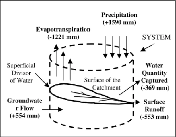
By using the values of ETR and the equation (2), the amount of the groundwater flow was evaluated. The mean annual groundwater flow received by this catchment during the period from 1998 to 2000 was 554 mm. This value was 34.84% of the mean annual precipitation (1590 mm) of the catchment. Fig. 7 shows the components of the annual water balance of the Ribeirão da Onça catchment. The dynamics of the groundwater flow in this catchment resulted from the geological
structure characterized with the karst. The impermeable rocks (filites, quartzites and diabase dikes) in the area determined the direction of the groundwater flow. The Ribeirão da Onça catchment presented areas of groundwater recharge that extrapolate the topographic divisors. The dynamics of the water was influenced by the phreatic divisons which were very different from the topographic ones in this area.
Figure 7 - Annual water balance of the Ribeirão da Onça riber catchment for the Period from 1998 to 2000
CONCLUSIONS
In order to understand the hydrological processes in the Ribeirão da Onça river catchment which offered water resources to the Curitiba Metropolitan Region, the present study applied a simplified water balance method and the modified Penman formula to the data obtained during the monitoring period from
1997 to 2000. The results showed the existence of significant groundwater recharge from other catchments to the study area and indicated that the simplified water balance method was not suitable for the hydrological study of this karst catchment. Analyzing the water balance, it was found that the catchment annually received the groundwater flow of 554 mm for the period from 1998 to 2000. A more precise analysis of
Surface Runoff (-553 mm) Precipitation
(+1590 mm)
Superficial Divisor of Water
SYSTEM
Groundwate r Flow (+554 mm)
Water Quantity Captured (-369 mm) Evapotranspiration
(-1221 mm)
the hydrological processes in karst areas requires long monitoring, longer than 10 years.
ACKNOWLEDGEMENTS
The authors are grateful to the SUDERHSA (Superintendence of Water Resources Development and Environmental Sanitation), especially Mr. Edson Sakae Nagashima and Mr. Nilson Antonio de Morais for supplying the discharge and precipitation data.
RESUMO
O presente trabalho teve como objetivo analisar os processos hidrológicos e avaliar o balanço hídrico da bacia hidrográfica do Ribeirão da Onça, no município de Colombo/PR, área de manancial da Região Metropolitana de Curitiba, para o período de monitoramento existente, de 1997 a 2000. Os métodos utilizados foram o do balanço hídrico simplificado e de Penman modificado. O método do balanço hídrico mostrou-se inválido para estimar a evapotranspiração real da área de estudo, por produzir valores negativos e superiores a evapotranspiração potencial, permitindo inferir que em determinados períodos, o volume de recursos hídricos extraídos é superior ao índice de precipitação, o que leva a deduzir que existem áreas de recarga do aqüífero externa aos divisores superficiais da bacia. O balanço hídrico da bacia do Ribeirão da Onça permitiu identificar a contribuição da água subterrânea, onde a média anual recebida pela bacia para o período de 1998 a 2000, foi de 554 mm/ano.
REFERENCES
Andreoli, C. V. et al. (1999), Limites ao Desenvolvimento da Região Metropolitana de Curitiba, Impostos pela Escassez de Água. SANARE Revista Técnica da Sanepar, Curitiba, 12 (12), 31-41.
COMEC. (1997), Relatório Ambiental: Região Metropolitana de Curitiba, Coordenação da Região Metropolitana de Curitiba, Curitiba.
Doorenbos, J.; Pruit, W. O. (1977), Crop Water Requirement. Irrigation and Drainage Paper 24, FAO, Rome, pp. 15-29.
IAPAR. (1994), Cartas Climáticas do Estado do Paraná. doc. 18. Instituto Agronômico do Paraná, Londrina.
Lisboa, A. A. (1997), Proposta de Metodologia, para Avaliação Hidrogeológica do Aqüífero Cárstico, Compartimento de S. Miguel. Master thesis, Universidade Federal do Paraná, Curitiba, Brasil. Marini, O. J.; Trein E.; Fuck, R. A. (1967), O Grupo
Açungui no Estado do Paraná. In: Bigarella, J. J.; Salamuni, R.; Pinto, U. M. Boletim Paranaense de Geociências (Geologia do Pré-Devoniano e Intrusivas Subsequentes da Porção Oriental do Estado do Paraná) Contribuição da Comissão da Carta Geológica do Paraná ao XXI Congresso Brasileiro de Geologia,Curitiba, 23 a 25, 43-104. Morton, F. I. (1983), Operational Estimates of Areal
Evapotranspiration and their Significance to the Science and Practice of Hydrology. Journal of Hydrology, Amsterdam, 66, 1-76.
Müller, I. I. (1995), Métodos de Avaliação da Evaporação e Evapotranspiração - Análise Comparativa para o Estado do Paraná. Master thesis, Universidade Federal do Paraná, Curitiba, Brasil.
Oliveira, S. M. (1999), Análise do Processo Chuva – Vazão de duas Bacias Hidrográficas na Região Litorânea do Estado do Paraná, através do Modelo de Tanque. Master thesis, Universidade Federal do Paraná, Curitiba, Brasil.
Vestena, L. R. (2002), Balanço Hídrico da Bacia do Rio Ribeirão da Onça, no Município de Colombo – PR.Master thesis, Universidade Federal do Paraná, Curitiba, Brasil.