Department of Sciences and Information Technologies
Predicting Space Occupancy for Street Paid Parking
Marco Hélio Ramos Silva
A Dissertation presented in partial fulfillment of the Requirements for the Degree of Master in Computer Science Engineering
Supervisor:
PhD. Professor Luis Nunes, Assistant professor at ISCTE-IUL
Predicting Space Occupancy for Street Paid Parking Abstract
Abstract
This dissertation discusses how to develop a prediction method for on-street parking space availability, using only historical occupancy data collected from on-street multi-space parking meters.
It is analyzed how to transform the raw data into a dataset representing the occupancy and how can this information be used to detect when the parking spaces on a street are Vacant or Full. Attributes like weather conditions and holidays are added to the data, giving them more context and comprehension.
After the data preparation and analysis, a prediction model is developed using machine-learning techniques that can forecast the availability of the parking spaces on a street at a specific day and on a given moment.
For that, a classification method is implemented based on decision trees and neural networks, comparing both methods regarding results and development time. Particular attention is given to the algorithm parameters, to achieve the right balance between accuracy and computational time.
The developed model proved effective, correctly capturing the different behavior of each street through the different weeks, and returning results useful to drivers searching for parking and to the business owners while monitoring their parking investments and returns.
Keywords: Parking space forecasting, street parking, traffic, parking guidance, machine learning, decision trees, neural networks
Predicting Space Occupancy for Street Paid Parking Resumo
Resumo
Esta dissertação apresenta como pode ser desenvolvido um método para previsão de disponibilidade de lugares de estacionamento em rua, utilizando dados históricos obtidos através de parquímetros de controlo a múltiplos lugares.
É analisado como os dados em bruto dos parquímetros podem ser transformados num conjunto de dados que represente qual a ocupação dos lugares, e posteriormente como esta informação pode ser utilizada para detetar se o estacionamento em uma rua está livre ou ocupado. São adicionados também mais alguns atributos, como por exemplo informação sobre as condições meteorológicas ou que dias são feriados, dando mais algum contexto e compreensão à informação já existente.
Após a preparação e análise dos dados, é desenvolvido um método de previsão utilizando técnicas de aprendizagem automática de modo a que seja possível saber qual a disponibilidade de estacionamento em uma rua, a um dia específico e a um determinado momento.
Para isso, foi implementado um método de classificação baseado em árvores de decisão e redes neuronais, comparando ambos os métodos do ponto de vista dos resultados e do tempo de desenvolvimento. Foi dada especial atenção aos parâmetros utilizados em cada algoritmo, de modo a que haja um balanço entre a precisão e tempo de computação.
O modelo desenvolvido mostrou ser eficaz, captando corretamente o comportamento de cada rua nas diferentes semanas, devolvendo resultados uteis aos condutores que procurem lugares de estacionamento e aos proprietários do negócio por lhes permitir monitorizar o desempenho dos seus investimentos em parques de estacionamento e qual o retorno.
Palavras-chave: Previsão de lugares de estacionamento, estacionamento em rua, tráfego, assistência ao estacionamento, aprendizagem automática, árvores de decisão, redes neuronais.
Predicting Space Occupancy for Street Paid Parking Acknowledgements
Acknowledgements
First of all, I would like to thank my family and close friends for their comprehension, giving me the support to stay focused and finish my dissertation.
My greatest acknowledgment is for Professor Luis Nunes for giving me the opportunity to develop this study and being my supervisor, having always time available to answer questions and discuss results.
A big thanks to all the colleagues that worked with me during the master degree, their work and effort helped me to achieve good results through the master and obtain valuable knowledge about every theme.
At last, I would like to thanks my friends and colleagues at work for giving me the flexibility and comprehension about the effort required to finish this dissertation.
Predicting Space Occupancy for Street Paid Parking Table of Contents
Table of Contents
Abstract ... i
Resumo ... iii
Acknowledgements ... v
Table of Contents ... vii
List of Tables ... xi
List of Figures ... xiii
List of Abbreviations ... xv 1. Introduction ... 1 1.1 Overview ... 1 1.2 Motivation ... 2 1.3 Research Questions ... 3 1.4 Objectives ... 3 1.5 Contributions ... 4 1.6 Research Method ... 5 1.7 Dissertation Structure ... 6 2. Literature Review ... 7
2.1 Parking Space Availability Methodologies ... 7
2.1.1 Based on Real-time Data and Infrastructures ... 7
2.1.2 Based on Offline Data ... 9
2.1.3 Comparison Between Methodologies ... 10
2.2 Prediction Modeling Techniques ... 14
2.2.1 Usage of Neural Networks in Parking Availability ... 14
2.2.2 Usage of Other Prediction Techniques in Parking Availability ... 16
2.2.3 Comparison Between Prediction Techniques ... 18
3. Case Study Background ... 21
3.1 Dataset Context ... 21
3.2 Development Process ... 25
3.3 Evaluation... 26
3.4 Development Tools ... 27
3.4.1 Dataset Analysis Using Excel and Visual Basic ... 27
3.4.2 Prediction Models Development and Evaluation Using Weka ... 28
Table of Contents Predicting Space Occupancy for Street Paid Parking viii 3.5.2 Random Forest ... 29 3.5.3 REP Tree... 29 3.5.4 Multilayer Perceptron ... 29 4. Dataset Analysis ... 31
4.1 Original Data Characteristics ... 31
4.1.1 Data Attributes ... 31 4.1.2 Data Distribution ... 33 4.1.3 Data Limitations ... 37 4.2 Dataset Transformation ... 38 4.3 Occupation Patterns ... 39 4.3.1 Occupancy by Zone ... 39 4.3.2 Occupancy by Street ... 41 4.4 Outlier Days ... 43
4.5 Weeks and Weekdays Behavior ... 45
4.6 Occupation Classes Classification ... 47
4.7 Prediction Based on Previous Weeks Values ... 48
4.7.1 Prediction Method ... 49
4.7.2 Occupancy Classes Definition ... 49
4.7.3 Results ... 51
5. Prediction Models Development ... 53
5.1 Dataset Attributes Enrichment ... 53
5.2 Occupation Classes Balance ... 55
5.3 Final Dataset ... 57
5.4 Prediction Models Testing ... 60
5.4.1 Algorithm Modelling ... 60
5.4.2 Training and Validation Data ... 61
6. Results Analysis ... 63
6.1 Algorithm Results using Default Values ... 63
6.1.1 Models with All Streets ... 63
6.1.2 Models by Zone ... 65
6.1.3 Models by Street Occupancy ... 67
6.1.4 Models with 2 Week Split ... 68
6.1.5 Algorithm and Dataset Performance Conclusions... 69
6.2 Attributes Relevance in Results ... 71
6.3 Algorithm Optimized Models ... 75
6.3.1 Algorithm Parameters Performance ... 76
Predicting Space Occupancy for Street Paid Parking Table of Contents
6.3.2.1 Models with All Streets ... 78
6.3.2.2 Models by Zone... 79
6.3.2.3 Models by Street Occupancy ... 80
6.3.2.4 Models with 2 Week Split ... 81
6.3.2.5 Models for Next Week Test Prediction ... 82
6.3.2.6 Models for Next Day Test Prediction ... 84
6.4 Comparison with Original Dataset Prediction ... 85
7. Conclusions and Future Work ... 87
7.1 Conclusions ... 87
7.2 Future Work ... 89
References ... 91
Annexes and Appendices ... 97
– Parking Records Distribution Ordered by Street... 99
– Parking Records Distribution Ordered by % Registries ... 101
– Parking Records Distribution by Date ... 103
– Graph of Parking Records Distribution by Date ... 105
– Parking Records by Parking Meter – Zone 1... 107
– Parking Records by Parking Meter – Zone 16 ... 109
– Parking Occupancy Averages ... 111
– Outlier Days ... 113
– Average Street Occupancy by Week and Weekday ... 115
– Occupation Correlation and AVD for Weeks and Weekdays ... 117
– Example of Parking Rotation and Classification ... 119
– Street Average Rotation at 10% High Demand Period Threshold .... 121
– Occupancy Prediction Based on Previous Weeks Values ... 123
– Classified Instances by Street ... 129
– Final Dataset Classes Distribution ... 133
– Algorithm Models Result - Default Parameters ... 135
– Sample of Decision Tree Generate by J48 ... 145
– Algorithm Parameters Performance Results ... 147
Predicting Space Occupancy for Street Paid Parking List of Tables
List of Tables
Table 1 – Studies comparison using different data acquisition methods ... 13
Table 2 – Comparison of studies results using different prediction techniques ... 20
Table 3 – Parking zone colors and respective paid times (EMEL, 2017c, 2017d) ... 24
Table 4 – Available parking places in the dataset zones (EMEL, 2015) ... 25
Table 5 – Attributes in the original data ... 32
Table 6 - Registries distribution by zone ... 33
Table 7 – Registries distribution by parking color ... 33
Table 8 – Streets that contain 50% of the registries ... 34
Table 9 – Registries distribution per month ... 36
Table 10 – Attributes in the time series dataset ... 38
Table 11 – Average rotation values for the 7 streets with higher occupancy ... 50
Table 12 – Averages results of prediction based on previous weeks ... 51
Table 13 – Contextual attributes added to the dataset ... 53
Table 14 – Number instances in each class according to percentage and threshold ... 56
Table 15 – Balance between occupation classes ... 57
Table 16 – Final dataset instances distribution using 3 classes ... 59
Table 17 – Final dataset instances distribution using 2 classes ... 59
Table 18 – Training and validation data random split ... 61
Table 19 – Training and validation data specific split ... 61
Table 20 – Training datasets contents and validation splits ... 62
Table 21 – Results using default parameters, for all streets with 3 classes ... 63
Table 22 – Results using default parameters, for all streets with 2 classes ... 64
Table 23 – Results using default parameters, training by zone with 3 classes ... 65
Table 24 – Results using default parameters, training by zone with 2 classes ... 66
Table 25 – Results using default parameters, training by occupancy with 3 classes ... 67
Table 26 – Results using default parameters, training by occupancy with 2 classes ... 67
Table 27 – Results using default parameters, testing for 2 weeks with 3 classes ... 68
Table 28 – Results using default parameters, testing for 2 weeks with 2 classes ... 68
List of Tables Predicting Space Occupancy for Street Paid Parking
xii
Table 31 – Datasets performance results using 3 classes ... 70
Table 32 – Dataset performance results using 2 classes ... 71
Table 33 – Raking and merit of the attributes in the dataset ... 72
Table 34 – Performance of RandomForest models by removed attribute ... 73
Table 35 – Performance of MLP models by removed attribute ... 74
Table 36 – Performance of J48 models by removed attribute ... 74
Table 37 – Algorithm parameters optimization comparison - 3 classes... 76
Table 38 – Algorithm parameters optimization comparison - 2 classes... 77
Table 39 – Algorithm modified parameters results for all streets - 3 classes ... 78
Table 40 – Algorithm modified parameters results for all streets - 2 classes ... 78
Table 41 – Algorithm modified parameters results by zone - 3 classes ... 79
Table 42 – Algorithm modified parameters results by zone - 2 classes ... 80
Table 43 – Algorithm modified parameters results by street occupation - 3 classes ... 81
Table 44 – Algorithm modified parameters results by street occupancy - 2 classes ... 81
Table 45 – Algorithm modified parameters results for 2 week split - 3 classes... 81
Table 46 – Algorithm modified parameters results for 2 week split - 2 classes... 82
Table 47 – Algorithm results for next week prediction - 3 classes ... 83
Table 48 – Algorithm results for next week prediction - 2 classes ... 83
Table 49 – Algorithm results for next day prediction - 3 classes ... 84
Predicting Space Occupancy for Street Paid Parking List of Figures
List of Figures
Figure 1 – Research method steps ... 6
Figure 2 – EMEL parking zones in the city of Lisbon (EMEL, 2015) ... 21
Figure 3 – On-street multi-space parking meter and parallel parking lots ... 22
Figure 4 – Detail of a multi-space parking meter and parking ticket ... 23
Figure 5 – EMEL parking zone color classification (EMEL, 2017e) ... 23
Figure 6 – Signs that indicate the street parking color (EMEL, 2017d) ... 24
Figure 7 – Development process steps ... 25
Figure 8 – Confusion matrix example ... 26
Figure 9 – Sample of the CSV file with original data ... 31
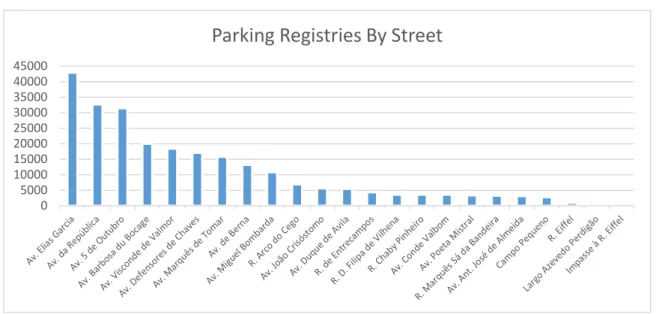
Figure 10 – Registries distribution by street ... 34
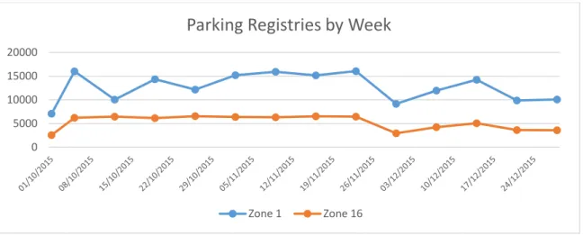
Figure 11 – Registries distribution by week ... 35
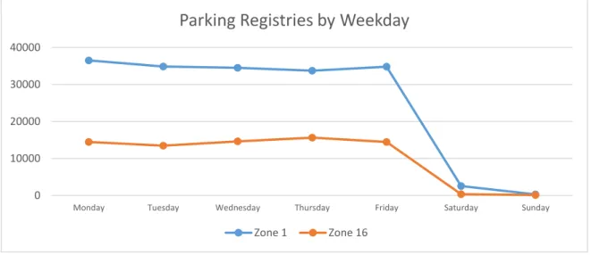
Figure 12 – Registries distribution by weekday ... 36
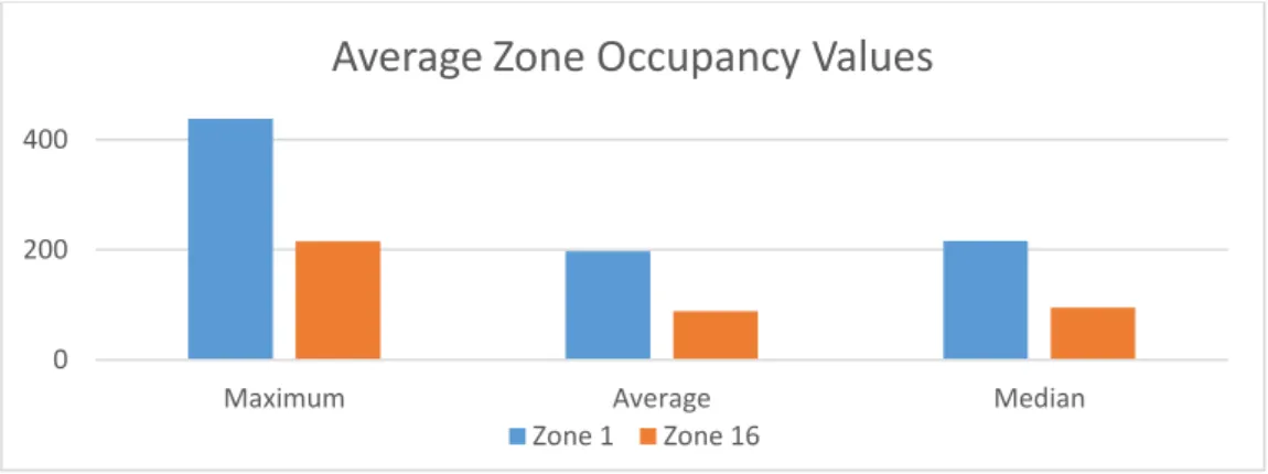
Figure 13 – Average zone occupancy values ... 39
Figure 14 – Average zone occupation during day ... 40
Figure 15 – Average zone registries during the day ... 41
Figure 16 – Average maximum occupancy values by street ... 41
Figure 17 – Average street occupation during day ... 42
Figure 18 – Average street registries during day ... 42
Figure 19 – Number of outlier days by street ... 44
Figure 20 – Number of streets with outlier by weekday ... 44
Figure 21 – Occupation and registries averages by week ... 46
Figure 22 – Occupation and registries averages by weekday ... 46
Figure 23 – Pseudo-code with the class balance removal method ... 58
Predicting Space Occupancy for Street Paid Parking List of Abbreviations
List of Abbreviations
ANN – Artificial Neural Networks
ARIMA – Auto-Regressive Integrated Moving Average AVD - Absolute Value of the Difference
BPNN – Back Propagation Neural Network CSV – Comma Separated Values
EMEL – Empresa Municipal de Mobilidade e Estacionamento de Lisboa FFNN – Feed Forward Neural Network
LR – Linear Regression GA – Genetic Algorithm GPS – Global Position System IQR – Interquartile Range MAE – Medium Average Error MLP – Multi-Layer Perceptron MLR – Multiple Linear Regression PGI – Parking Guidance Systems PUK – Pearson VII Universal Kernel
QREN – Quadro de Referência Estratégico Nacional REP – Reduced Error Pruning
RBF – Radial Basis Function RT – Regression Tree
SLR – Simple Linear Regression
SMOTE – Synthetic Minority Over-sampling Technique SVM – Support Vector Machine
SVR – Support Vector Regression VBA – Visual Basic for Applications
WEKA – Waikato Environment for Knowledge Analysis WNN – Wavelet Neural Network
Predicting Space Occupancy for Street Paid Parking 1. Introduction
1. Introduction
This chapter describes the study theme presented in this document and the research motivations. It explains the addressed questions and their relevance in society.
1.1 Overview
In modern cities and urban areas the traffic is steadily rising, leading to an increase in travel time, congestions and health risks (Pflügler, Köhn, Schreieck, Wiesche, & Krcmar, 2016). Under these circumstances, locate an empty parking place can be a problem and a time-consuming task that can take an up to 30% the cruising time (Shoup, 2006), and this issue can be even more severe under specific conditions, like rainy weather or special events.
These situations cause a decrease in the quality of life, because a citizen may have preferred to use an alternative transportation, especially if he is non-resident or with little knowledge about parking locations and possible availability.
One way to reduce the unneeded cruising time and its consequences are by providing for the drivers a system where they can predict in advance if there are any parking spaces available, in a given area at a given time.
Parking spaces are a limited and valuable resource in cities, which if not regulated will lead to an increase in traffic and even worst life conditions because every citizen will tend to drive their cars to the destiny location. Directly related to the increase in cruising time is the underpricing of on-street parking, generating a waste of time, resources and revenue. The correct adjustments in the prices according to the demand will create more vacant parking spaces and reduce cruising, without decreasing the revenue (Van Ommeren, Wentink, & Rietveld, 2012). The earnings from parking’s are important to the cities because they use them as an asset to fund their finances, so a system that allows a better management of the parking spaces may allow an increase in the income, better zone pricing and better investment plans (Tiedemann, Thomas, Krell, Metzen, & Kirchner, 2015).
In the last years, many parking lots implemented Parking Guidance Systems (PGI), but these systems can be expensive because they rely on external sensors that are not always
1. Introduction Predicting Space Occupancy for Street Paid Parking
2
1.2 Motivation
The purpose of this study is to analyze parking space occupancy using historical data from on-street parking meters to develop a prediction method for parking space availability. The objective is to develop a method suited for on-street parking, where is not easy to install sensors to collect data and provide real-time information.
Sensors require a good maintenance to keep the system accurate and precise, assuring that they are not damaged due to their exposition to the public and the weather. In the case of malfunction, sensors can easily have timing failures, compromising the system’s reliability. Taking into consideration the maintenance costs is important because they represent an extensive effort that is vital to the system. If a failure happens and the system generates incorrect results the drivers eventually will stop trusting them. By only using data from the already existing parking meters, it is ensured that no that no other investments are necessary and that the existing equipment is enough to collect the required data. These type of systems are more affordable to the municipalities and allow a quicker implementation.
Searching for parking locations may originate slow traffic and jams, this is increased by the traffic of drivers that are nonresidents, since residents may already have some knowledge, based on previous experience, of where free parking space may be located. Tourists or outsiders represent a significant percentage of the cruising drivers, and these do not have any knowledge of the parking locations, having to slow down to search for one in their eye of sight originating heavy traffic.
Predicting parking space usage allows the drivers to know in advance the feasibility of using their cars in a specific area according to the free parking space prediction. By doing this, the driver can better plan his schedule and route, or even decide to travel using alternative transportation.
As a consequence, the fuel consumption is reduced, benefiting the environment and creating cleaner cities, allowing them to reach their pollution targets easily (Richter, Di Martino, & Mattfeld, 2014).
Predicting Space Occupancy for Street Paid Parking 1. Introduction
1.3 Research Questions
The focus of this research is on data exploration and prediction models using machine learning methods. With the collected information, the objective is to use machine learning and their recent developments to create optimized models that generate predictions with an acceptable confidence level.
This research seeks the answer to the following questions:
In the parking spaces of the studied areas, is it possible to establish any patterns between the different days of the week and the different hours of the day?
The data collected from the on-street parking meters is enough to create predictions with an acceptable confidence level?
Is it possible to obtain accurate short (a few hours) and medium-term (2 or 3 days in advance) predictions with a dataset containing only historical data from a short time-span (3 months)?
How effective is the precision of a prediction model built using decision trees when compared to a model using neural networks?
Is the training of the models efficient enough to be executed daily without requiring dedicated or external computational systems?
1.4 Objectives
This work presents the results of applying prediction models based only on historical data collected from the existent on-street parking meters. After the creation of the models, their accuracy is tested in predicting if a parking space is full or not at a given moment in a specific parking zone.
From the business point of view, knowing in advance the parking occupancy at a given time allows the city entities to anticipate specific actions, like creating temporary parking spaces or route the traffic to another parking in the surrounding areas. Having the knowledge of how the parking demand increases in a specific zone allows for a better strategy choice when deciding the creation of new parking zones, enabling the business to create opportunities where they have bigger earnings and better long time return.
1. Introduction Predicting Space Occupancy for Street Paid Parking
4
1 - Inform the clients through the website of the predicted occupation of a parking area at a given moment in the future;
2 - Detect anomalies in the regular pattern of parking occupation;
3 - Reorganize inspection teams to the zones with the biggest parking occupancy prediction;
4 - Readjust parking fees according to the average occupancy of a given area;
5 - Decide the location of new parking spaces according to the average occupation prediction.
From the user's point of view, the resolution of this problem allows them to know in advance if it is feasible to use their vehicle to reach a destiny or if is better go to a different location with an alternative parking, or even in another way of transportation. This reduces their cruising time, fuel consumption and, as a consequence, the air quality increases.
The creation of a system that provides parking availability forecast allows the business to increase the user satisfaction, establishing a proximity relationship with the clients and enhancing the company image.
1.5 Contributions
This thesis consists in the prediction of parking spaces availability, but it applies to on-street parking, which is a topic less studied since is more difficult to collect data outside closed parkings and to verify its accuracy.
The studied developed used historical data acquired from on-street multi-space parking meters, while other studies on this theme used data collected from individual sensors in closed parking. Individual sensors may have the capacity to provide real-time data, allowing a precise control of the parking status and to feed data into algorithms used in short-term occupancy prediction, however the application of sensors is not always feasible. By using historical data, this study demonstrates how this data is useful in the identification of parking patterns and the precision of the predictions developed with it.
The usage on multi-space parking meters creates more difficulties in obtaining the occupancy for a specific street, since these meters are not street specific and they may have registered parkings of neighbor streets.
Predicting Space Occupancy for Street Paid Parking 1. Introduction
In the city where this study is based is possible to obtain parking permissions, which will result in parking places that are occupied but not registered in the parking meters. On-Street parking is also more prone to illegal parking that will also be occupied spaces not registered.
To deal with these issues and obtain the parking occupancy status, it is developed a method to analyze the data and then calculate if the parking on a street is “Vacant” or “Full”, using the number of registries combined with peak occupation values.
While neural networks are used in many parking prediction studies, decision trees have also been used with success, being faster to execute and easier to develop. This study compares these two methods, analyzing how they perform and the effort required to develop them.
1.6 Research Method
This study performs an explanatory research in the forecast of parking places availability, seeking to establish a relation between a set of relevant attributes in the dataset and the prediction result, without individual study of each specific variable.
In a first stage, an exploratory research on the dataset is executed, analyzing it and searching how to extract information from it.
In a second stage, it is done an explanatory research developing a prediction method based on the latest studies in Machine Learning.
Using the dataset, several models are developed to verify if a generic model of all zones is accurate, or if better results are achieved splitting the dataset according to other characteristics, such as zones or by behavioral patterns, like the number of registries in a day.
Figure 1 exhibits the several steps that occur in the used research method, beginning with problem definition, dataset preparation and then model development. This is an iterative process. The dataset is refined and the model is readjusted at each iteration to obtain more accurate results. The iteration process is important because the fine tuning of the dataset and model parameters has a relevant impact on the results, so this approach allows small optimizations to be made and compared with previous results (Zheng, Sutharshan, & Christopher, 2015).
1. Introduction Predicting Space Occupancy for Street Paid Parking
6
Figure 1 – Research method steps
The developed model is tested by applying it to a portion of the dataset that was not used in training, being the results of this test evaluated using quantitative analyses, based on statistical metrics and execution time. The expected performance will be a good balance between accurate prediction results and a fast execution time.
1.7 Dissertation Structure
This dissertation is divided into seven chapters, each one having the following content: • Chapter 1. – Introduction: Present chapter, explaining the theme and objectives of this
dissertation;
• Chapter 2. – State of Art: Describes all research made during the development of this study;
• Chapter 3. – Case Study Background: Introduces the dataset and context where this dissertation is developed, tools and methods used;
• Chapter 4. – Dataset Analysis: Exploration and comprehensive analyses of the dataset, observing the data behavior and the type of attributes included; • Chapter 5. – Prediction Models Development: Elaboration of the models using
different samples of the dataset and algorithms, evaluating their performance and how can they be optimized;
• Chapter 6. – Result Analysis: Present and compare the results according to the different experiments and contextualize them;
• Chapter 7. – Conclusions and Future Work: Dissertation conclusions and what type of works can be done in the future to improve results;
Predicting Space Occupancy for Street Paid Parking 2. Literature Review
2. Literature Review
This section presents the current state of the art in prediction methodologies and data acquisition. Some of the authors focused on problems similar to the subject of this document, and this review shows the approaches they used and the results obtained.
The first part of this chapter describes the different techniques and devices used to acquire parking allocation data, presenting the studies conducted according to each technique.
The second part introduces the type of methods used to predict parking lot occupancy, the performance obtained with each one and the type of data used.
2.1 Parking Space Availability Methodologies
Predicting parking space occupancy has been a subject of study for some time but with an increase in recent years. The advancements in computing processing power, mobility, smart vehicle technologies, IoT, integrated sensors and communications lead to new approaches to the problem, seeking to obtain more efficient and accurate results.
The different methods used vary in the way that the data is collected and calculated, having this direct impact on the type of infrastructure needed, implementation time and costs.
2.1.1 Based on Real-time Data and Infrastructures
Acquire the parking occupancy data and calculate the demand in real-time is possible with the current technologies by using sensors or cameras, and networks (Klappenecker, Lee, & Welch, 2014). Selecting which technology to use depends on the project objectives, environmental factors, parking type and available infrastructure (Mainetti et al., 2016).
Technologies based on image use cameras as a sensor to monitor parking spaces and then process those images with software to detect parking space occupation. One method is to use them to track the incoming and outgoing cars and then calculate the lot occupancy,
2. Literature Review Predicting Space Occupancy for Street Paid Parking
8
many remain vacant. Cameras can be difficult to tune to provide good accuracy, since they are sensitive to weather and changes in light conditions, resulting in distortions, oscillations, occlusions, and shadows that can be misinterpreted (Huang & Wang, 2010).
Wu, Huang, Wang, Chiu, & Chen (2007) developed a method that used images captured by a camera to detect empty or occupied parking, making it possible to use this system with existing surveillance cameras. Each image is subject to a preprocessing that divides them into patches containing three parking spaces that are then classified using an SVM (Support Vector Machine), obtaining an average accuracy of 85%. Another possibility is to capture an aerial image from multiple cameras and analyze the parking lot structure using an algorithm based on terrain elevation and intensity, recognizing by the elevation which parking spaces are vacant. The result of this allows extracting the parking lot activity to later visualize in the form of parking activity simulations (Wang & Hanson, 1998).
Another method uses only one aerial camera to detect the parking structure using block prediction, interpolation, and extrapolation. This method proved effective but sensitive to light conditions (Seo, Urmson, & Ratliff, 2009). Delibaltov, Wu, Loce, & Bernal (2013) used cameras mounted on public lamp-post to automatically detect parking space occupation based on the parking space geometry. The method, when tested at the University of California Santa Barbara, had an average accuracy of 76% under different weather conditions.
Technologies based on another type of sensors use one sensor by parking space to detect if it is vacant or not (Yamada & Mizuno, 2001). According to the purpose and the type of conditions in the parking lot different type of sensors are used, and they can be divided into two categories: intrusive and non-intrusive. Intrusive sensors are installed under the pavement and typically are piezoelectric sensors, weight-in-motion or magnetometers. Non-intrusive sensors are usually fixed on the ground or in the ceiling, being usually ultrasonic sensors.
In Italy, the city of Pisa monitors the parking in Piazza Carrara using sensors mounted on the ground that detect if a parking space is occupied or vacant. This information is then centrally processed and displayed in PGI and also in a mobile application to guide users searching for a free parking space (Tsiaras, Hobi, Hofstetter, Liniger, & Stiller, 2015).
Parknet is a platform that uses ultrasonic sensors and GPS mounted in cruising vehicles to monitor parking availability and then send this information through the network to a centralized server, being this solution tested in the city of San Francisco with an accuracy of 90% (Mathur et al., 2010).
Predicting Space Occupancy for Street Paid Parking 2. Literature Review
2.1.2 Based on Offline Data
In some parking lots obtaining real-time data is either difficult or too expensive, especially if it is on-street parking. In this type of parking, the outdoor conditions make sensors installation difficult, sometimes requiring a bigger infrastructure when compared to off-street parking, which increases the final costs. In the outdoor, the exposition of the sensors to an uncontrolled environment creates difficulties in their accuracy and reliability (Tamrazian, Qian, & Rajagopal, 2015).
To control occupancy, most parks rely on parking terminals for off-street parking and parking meters for on-street parking. These systems can store the parking registries they make, and that data can be used to create a historical record of past parking occupancy behavior and predict occupancy rates. (Tamrazian et al., 2015)
The prediction methods based on offline data have proven useful even when real-time monitoring sensors are available. Caicedo (2009) developed a statistical model that combines the use of historical and real-time data from sensors to predict parking occupancy and then inform in advance if an off-street parking facility is full.
To increase the accuracy, this model was enhanced with simulations, being later tested and validated with data from a parking facility on Barcelona (Caicedo, Blazquez, & Miranda, 2012).
Real-time data can detect that there are parking spaces vacant at a given moment, but can’t assure that those spaces are still available when the vehicle arrives. Because of this, Rajabioun (2013) developed a system where he combined the real-time data with historical data to ensure that the parking place is still available at the arrival time. Pullola, Atrey, & Saddik (2007) developed a GPS navigation system to find available parking spaces that also used real-time data mixed with historical data to build an accurate prediction model.
The city of San Francisco hosted an experiment where GPS and phone accelerometers were used to detect when a car was parked or moving, registering those values to build a historical profile. That data was used to create a historical model that predicts the parking occupancy of a specific zone. (Xu et al., 2013)
Using only historical data Liu, Guan, Yan, & Yin (2010) developed a prediction model for parking space occupation using chaotic time series forecasting methods. The model was successfully tested in the city of Beijing, China.
2. Literature Review Predicting Space Occupancy for Street Paid Parking
10
smartphones or in-car systems. The challenge in these cases is to obtain the maximum accuracy using the smallest set of data so that models can be quickly retrained with new data.
2.1.3 Comparison Between Methodologies
Collecting data using sensors can provide real-time information about the occupancy status of a parking lot, but the type of sensors used has an impact on the result. Magnetic field sensors are typically applied in large parks to obtain individual parking space occupancy status, but they require some construction in the parking lot. They work relatively well because they interact with the ferrous parts of the vehicles detecting if the parking space is occupied. By measuring the changes in the sensor magnetic field is also possible to detect if a car has passed or not and the type of vehicle that passed or parked (Burgstahler, Knapp, Zöller, Rückelt, & Steinmetz, 2014). The sensitivity of these sensors can be a problem, since residual magnetism or imprecise parameters during the manufacturing process can affect the sensor behavior, creating difficulties in calibrating them. Also, the same model or type of vehicle can have variations in their magnetic resistance, causing invalid reads from the sensors (Markevicius et al., 2016).
Ultrasonic is another type of sensors, having a lower cost and the possibility of being installed on the ceiling above each parking space, making them easier to install (Mimbela & Klein, 2000). They work by emitting an ultrasonic wave and then reading the time that takes the wave to return. By measuring the differences in the wave return time is possible to detect if a parking space is occupied or vacant. The disadvantage of these sensors is that they are sensitive to temperature changes and heavy air turbulence, generating wrong values that can give misleading results. (Kianpisheh, Mustaffa, Limtrairut, & Keikhosrokiani, 2012)
Sensors of another type are less common but can also be found in parking lots, like infrared, microwave radar or RFID (Geng & Cassandras, 2013).
Despite the type of the sensor, their usage is not always feasible to every parking because of their installation and maintenance costs that increase under some parking conditions like on-street parking. Another issue is that they have to be individually installed in each parking space, requiring labor time and arrangements in the existent infrastructure. The costs can be partially recovered by an aggressive ticketing of parking violations (Klappenecker et al., 2014). Installing sensors usually requires the installation of a wired network, since they
Predicting Space Occupancy for Street Paid Parking 2. Literature Review
generate a significant amount of data that sometimes is complicated to transmit wirelessly, especially in the case of cameras (Mainetti et al., 2016).
Cameras can be used to monitor large portions of a parking lot, but their sensitiveness requires correct placement, being image filtering also crucial to obtain images with enough quality (Burgstahler et al., 2014). As previously discussed, Wang & Hanson (1998) also stated these problems, and despite their system proved effective on parking lots with sparse vehicles it is difficult to install the camera at the required height and angle. The poor quality line parking marks are difficult to capture on camera, making the process of detecting available parking spaces a difficult task (Seo et al., 2009).
Real-time data gives a good representation of the status of a parking lot, but this information is valid only for a limited amount of time (Caliskan, Barthels, Scheuermann, & Mauve, 2007). Sometimes a delay in data refresh causes the system to work with outdated information, meaning that when the driver arrives the parking place is no longer free (Rajabioun & Ioannou, 2015). Several reasons contribute to the outdated information, like the time that cameras take to process the images or that the sensors take to communicate or refresh their status. These failures inevitably originate noise, corrupted data and missing observations, requiring the use of prediction algorithms that work well in these conditions (H. Chen, Grant-Muller, Mussone, & Montgomery, 2001).
Offline data does not give real-time feedback, but its usage has some advantages because it allows data filtering and analysis. It also does not require dedicated equipment because raw data is collectible from already existing sources like parking meters or even accumulated data from real-time sensors. The analysis of this type of data allows the observation of how the occupancy behaved in the past and what patterns emerge from it, creating a better understating of peak hours during the day and constantly occupied areas (Tamrazian et al., 2015).
Because offline data is usually analyzed as a trend in time, it is important to detect outliers in data since they can negatively affect the results. Like in real-time data, these outliers can appear because of failures in the equipment or the network, but they can also appear from external factors that are not possible to determine when analyzing the data. The advantage of offline data is that it is possible to detect these outliers and eliminate them, obtaining a cleaner data and more accurate results (Piovesan, Turi, Toigo, Martinez, & Rossi, 2016).
It is also possible to search for patterns to create clusters that contain specific behaviors under certain conditions, allowing a more clear comprehension of the data (X. Chen, 2014).
2. Literature Review Predicting Space Occupancy for Street Paid Parking
12
of the data, thus allowing a reduction in size and better computation times (Yan-jie, Tang, Wei-hong, Phil, & Wang, 2014).
With historical data it is possible to develop prediction models and simulations that allow verifying the data behavior in the future, making it possible to modify certain attributes and observe if the current behavior is maintained or changed. (Caicedo et al., 2012). It is also possible to add contextual attributes to the data, like weather conditions, special events or roadworks. This allows a more comprehensive learning of how changes in the environment affect the obtained data and provide a better understanding of which situations are addressable and which ones are difficult to control (Andrea, Klaus, & Walter, 2000).
The prediction models and simulations developed present the trend behavior of the occupancy at a given moment under certain conditions, and do not take into account sudden changes. When compared to real-time data, offline data cannot produce precise results when a deep or sudden change occurs in a way that affects the results (Tamrazian et al., 2015).
The type of attributes originally contained in the offline data can influence the type of study conducted, mainly when using passive elements that do not have detection capabilities, like on-street parking meters. This kind of devices usually relies on manual interaction with them to detect that a vehicle has arrived at the parking space, but they cannot automatically detect when that vehicle leaves. With parking meters is also not possible to detect if the car left exactly when the paid time ended, or if a car is parked and has not paid at all like in the case of cars with parking licenses. This type of situations should be addressed when analyzing the data by verifying how all the attributes interact with each other and what kinds of patterns the data follows (Caicedo et al., 2012).
Table 1 presents a list of studies performed using different data acquisition methodologies and the results obtained.
Predicting Space Occupancy for Street Paid Parking 2. Literature Review
Paper and Author Type of Data Limitations Results
Robust Parking Space Detection Considering Inter-Space Correlation (Wu et al., 2007)
Real-time data collected from multiple aerial cameras.
Vehicle shadows and occlusion may difficult the detection of a parked vehicle.
85% accuracy in identifying occupied spaces using SVM.
Parking lot occupancy determination from lamp-post camera images
(Delibaltov et al., 2013)
Real-time data collected from cameras on a public lamp-post.
Different light
conditions, fog, rain or image resolution, may affect the result.
76% average accuracy in identifying occupied spaces.
ParkITsmart: Minimization of cruising for parking (Tsiaras et al., 2015)
Real-time data collected from individual ground sensors.
Sensor cost and placement have a big deploy and maintenance cost.
80% reduction in the time searching for parking.
Intelligent parking assist (Rajabioun et al., 2013) Real-time data combined with historical data of parking occupancy. The performance decreases as the prediction time distance increases.
1.2% average error for 10 minutes ahead prediction
2.8% average error for 40 minutes ahead prediction. Where Is My Parking
Spot?
(Tamrazian et al., 2015)
Offline historical data from parking meters, enriched with contextual attributes.
Precise arrival time is difficult to estimate because the parking meter resides at the entrance of the lot.
7.4% medium average error.
Unoccupied Parking Space Prediction of Chaotic Time Series (LIU et al., 2010)
Offline data, collected from individual sensors.
The system is effective, but the data collection is based on individual sensors.
2.33% average prediction error.
2. Literature Review Predicting Space Occupancy for Street Paid Parking
14
2.2 Prediction Modeling Techniques
Predictive models are an advanced way to forecast events in the future based on data from past events. From all the existent prediction techniques, Artificial Neural Networks (ANN) is often considered in the literature as a separated approach, mainly because of the differences in the way it is modeled and interpreted (Karlaftis & Vlahogianni, 2011).
ANN is a method of building predictive models that use algorithms to simulate the functions of a human brain, containing several layers each one with a number of neurons, being these interconnected through links with weights (M. Al-Maqaleh, A. Al-Mansoub, & N. Al-Badani, 2016). They have excellent ability to recognize and classify patterns (E. I. Vlahogianni, Golias, & Karlaftis, 2004), being able to learn and adapt from the original data (Blythe, Ji, Guo, Wang, & Tang, 2015).
Many studies used prediction models based on other techniques, like Support Vector Machine, Regression Trees or Markov Chain, that have been the prediction standard for several years because of their simplicity and easy comprehension (Sargent, 2001). They can be fast, efficient and easier to develop, but may lose accuracy when used with high complexity data and with low correlation (Karlaftis & Vlahogianni, 2011).
In the literature of parking availability prediction, many studies focused specifically on ANN, while others try to establish a comparison between ANN and other techniques.
Because of these differences between the techniques, there is a subchapter dedicated to the usage of ANN in parking prediction, where a literature review on these techniques is presented as well as the obtained results, being this latter discussed and compared to the other techniques.
2.2.1 Usage of Neural Networks in Parking Availability
ANN is shown in literature as a good alternative to the other techniques since they can approximate almost to any function despite its degree of linearity and without knowledge of its functional form (Kumar, Parida, & Katiyar, 2013). They try emulate the cognitive capability of the brain using a set of interconnected neurons, each one having its specific input/output and characteristics (Vasudevan & Parthasarathy, 2007).
They are efficient when working with noisy data or with low correlation and also very flexible and robust when dealing with multi-dimensional data. Their capacity to generalize and learn make them effective in the development of prediction models (Karlaftis &
Predicting Space Occupancy for Street Paid Parking 2. Literature Review
Vlahogianni, 2011) and very suitable for predicting events where little is known about the relationship between the different data attributes. In this case and if enough training data is available is possible to use the neural network to derive the required information by training with the data. ANN also has the advantage of continuous learning, because their training dataset can gradually be enriched with more data so that the prediction performance continuously increases. The ANN hidden layers allow the prediction models to consider nonlinear relationships and interactions between the data attributes (Pflügler et al., 2016).
Yang, Liu, & Wang (2003) developed a prediction model based on ANN to forecast parking spaces using as input a set of variables with contextual data like road traffic flow, weather, specials events or road conditions. The system was implemented in the city of Beijing and proved effective in the reduction of recirculating traffic.
E. Vlahogianni, Kepaptsoglou, Tsetsos, & Karlaftis (2014) used an ANN to predict parking occupancy up to one hour ahead. Their system has two models; the first applies survival analysis to predict the probability of a parking space being free for the next time intervals, and the second introduces ANN for the prediction of the time series of parking occupancy in different regions of an urban network. They tested the model in the city of Santander, Spain, and proved that neural networks adequately captures the temporal evolution of parking space availability and can accurately predict occupancy up to one hour ahead.
Fengquan, Jianhua, Xiaobo, & Guogang (2015) developed a prediction model based on back propagation neural networks (BPNN) to calculate the number of remaining parking spaces. They used historical data collected from sensors, and the dataset is constantly updated in real-time with the data gathered from those same sensors. The system was tested with data from a closed parking space in the city of Nanjing in China and proved effective, despite the fact that some error always exists due to big and sudden variations in the number vacant parking spaces during the day.
Blythe et al. (2015) used the parking occupancy data from several off-street parking spaces in Newcastle, England to study and develop a model for short-term parking availability prediction. They analyzed and enriched the data with contextual information and then used it to build a Wavelet Neural Network (WNN) for prediction, creating different models for workdays and weekends since the parking behavior is different between these days. They concluded that the accuracy and training time of this method is appropriate for short-term forecast of available parking spaces and can provide valuable information to the
2. Literature Review Predicting Space Occupancy for Street Paid Parking
16
2.2.2 Usage of Other Prediction Techniques in Parking Availability
Prediction techniques like Regression Trees or Support Vector Machine have widespread usage, and provided good results in the forecast of parking space availability (Zheng et al., 2015). The statistical theory used by them is well known, allowing the users to understand the influence of each attribute in the dataset, giving them the ability to verify the model established assumptions including issues of adequacy and fit (Sargent, 2001).
With these techniques it is possible to make prediction models for regression or classification, depending if the desired outcome is a number or category. The adequacy of each method and the developed model varies according to the dataset and its attributes. It is necessary to evaluate the different methods performance by comparing the error between the predicted values and the known values (Lijbers, 2016).
Zheng et al. (2015) developed prediction models using Regression Trees (RT) and Support Vector Regression (SVR). RT is a type of decision tree, it consists of multiple nodes with each branch representing a different outcome, having leafs that represent the prediction result. This method is fast to train and is easy to interpret the built model by simply analyzing the tree, verifying what are the most important attributes. SVR is a type of Support Vector Machine (SVM) modified to predict numeric values, having the advantage of being sensitive to changes in patterns of the dataset (Lijbers, 2016). Using two parking spaces datasets, one from the city of Melbourne, Australia, and another from San Francisco, USA, they compare the performance and accuracy of the models in predicting the occupancy rate of the parks. They concluded that the regression tree was the more accurate model and the least computationally intensive (Zheng et al., 2015).
Caliskan, Barthels, Scheuermann, & Mauve (2007) developed a short-term prediction algorithm using Markov Chain theory and tested it with real-time information from parking lots. The objective was to predict the available parking at the driver’s time of arrival based on the current park occupation, and by consequence reduce the amount of traffic generated by the search for free parking. The algorithm consists of modeling the parking lot as queue and using a Markov Chain with distributed inter-arrival and parking times to describe it. They tested the model with a simulation using historical data from the city of Brunswick, Germany, and results proved that the model was effective in reducing the effort to search for free parking. Yanjie, Wey, & Wey (2007) developed a prediction model where a weighted Markov Chain was combined with wavelet analysis of the parking occupation time series. The objective was to use the wavelet analysis to detect low signals that will represent trends
Predicting Space Occupancy for Street Paid Parking 2. Literature Review
and high signals that will represent unusual events in the parking occupation. The time series wavelet is then reconstructed according to this analysis, and the weighted Markov Chain is used to create the forecast. This method was tested in Nanjing, China and proved to be accurate when using a system that can provide real-time occupancy data.
Clustering analysis is a statistical estimation method that recognizes patterns in data based on the distance and correlation between the elements. An, Han, & Wang (2004) used this method to develop a system to dynamically guide the drivers to the zone with most probability of having vacant parking lots, where they proved that their system creates more balance between parking lot occupancy in situations of low or high demand. Richter et al. (2014) also used clustering to detect similar patterns in data so that will be possible to reduce the amount of historical data to be stored while assuring that the data can still provide enough information to build accurate prediction models. They concluded that the clustered models are accurate but with an inferior performance when compared to a full dataset model, but the storage needs are reduced by 99.03% when working with clusters.
Cherian, Luo, Guo, Ho, & Wisbrun (2016) conducted a study where they used regression to build a prediction model for parking garages occupancy in urban areas. They compared several statistical regressions methods namely, Simple Linear Regression (SLR) with only one attribute, Multiple Linear Regression (MLR) with seven attributes, and SVR with different kernel functions. In their experiments, they concluded that the best performance was achieved with SVR when using Pearson VII Universal Kernel (PUK) and that the performance accuracy increased when more contextual attributes were added to the data.
Fengquan et al. (2015) used a linear time series Autoregressive Integrated Moving Average (ARIMA) model to predict the number of unoccupied parking spaces. The forecast used real-time data acquisition of remaining vacant spaces, constant update of the datasets time series and constant correction of model parameters by applying real-time data. The model was tested in a central mall parking lot in Nanjing, China, and proved accurate for real-time usage.
Tamrazian et al. (2015) used k–nearest neighbors to develop a model of parking prediction that was constantly updated with real-time data. This algorithm has the advantage of quickly identifying the different trends that the occupancy is following based on the real-time data it is observing, allowing for more accurate predictions. It also has the advantage of being efficient since no training is required. The model was tested in two parking lots in the Stanford University, California, and provided accurate predictions with a decrease in
2. Literature Review Predicting Space Occupancy for Street Paid Parking
18
2.2.3 Comparison Between Prediction Techniques
One of the problems with ANN is their “black box” concept. In the other techniques, it is usually possible to find the effect and influence of each variable, while in neural networks is difficult or not possible at all to find these types of relations (Kumar et al., 2013). When using a technique like regression is possible to sequentially explore and eliminate variables that do not contribute to the model. It is also possible to make hypothesis testing between the explanatory variables and the intended result. This type of exploration is not feasible while using ANN, and they have the additional drawback of being computationally intensive (Sargent, 2001). Yang, Liu, & Wang (2003) stated that in the ANN forecast model he developed the precision increased with bigger datasets, but that will also increase the computing time which may not be acceptable for a real-time application. He also pointed out that selecting the appropriate number of implied neural units is difficult and important since it affects learning time, precision and convergence.
Because of these concepts, it is difficult to model and correctly define the parameters for an ANN. There is no specified general methodology to design them, and several authors used a trial and error approach leading to uncertainty when designing the neural network (E. Vlahogianni, Karlaftis, & Golias, 2005). This approach tends to be time-consuming for the researchers that have to rely on their previous experiences to try to define the neural network architecture, number of input variables, number of hidden layers, activation or transfer function and selection of learning or training algorithm (Kumar et al., 2013). Methods based on Genetic Algorithm (GA) try to solve this problem, helping in the selection of the parameters that model the neural network (E. Vlahogianni et al., 2005). Bashiri & Farshbaf Geranmayeh (2011) also proposed a method to find optimal parameters for a neural network using GA concluding that using them the network will have better performance that when compared to the random parameter selection.
While ANN emphasizes on implementation, the other techniques emphasize on estimation and inference, so that it is possible to provide a model and to offer insights on the data and its structure. ANN does not target interpretation, but instead aim to provide an efficient way regarding accuracy and development time to represent the underlying properties of the data and offer good predictions for the subject in study (Karlaftis & Vlahogianni, 2011).
Some studies used alternative prediction methods or variations like event-driven models combined with prediction techniques. Andrea, Klaus, & Walter (2000) developed an
event-Predicting Space Occupancy for Street Paid Parking 2. Literature Review
driven forecasting model to predict on-street parking availability without real-time data and successfully validated the model in the city of Munich, Germany. Teodorović & Lučić (2006) also develop a method that combines simulation, optimization, and fuzzy logic, and they were able to successfully forecast if a park is full or not at a given moment.
Fuzzy logic can also be used alternatively as prediction technique, as demonstrated by Chen, Xia, & Irawan (2013) that developed a model to predict short-time parking availability using historical data from 2 weeks of parking occupancy. Then taking into consideration the current location of the driver, time of the day and his arrival location, the model estimates the trip duration and predicts the expected occupancy in nearby parks at the time of arrival, indicating to the driver the ones expected to have vacant spaces. The model was successfully applied to the city of Perth, Western Australia, providing accurate results quick enough to be used in real-time.
Some authors directly compared prediction models developed with ANN and other techniques, but the achieved results vary according to the characteristics of the dataset and the desired performance.
H. Chen et al. (2001) developed a prediction model based on ARIMA and compared it to other models: two models based on ANN, one based on Radial Basis Function (RBF) and another one based on Multi-Layer Perceptron (MLP). They use the models to predict traffic, which is a different problem but faces the same time series difficulties as parking prediction. The models were used to forecast traffic in a highway and to observe its tolerance to missing data, concluding that when compared to ARIMA both neural networks are more accurate and less sensitive to missing data, generating predictions that are reliable even in a 12 month forecast horizon (Karlaftis & Vlahogianni, 2011).
Another study used a dataset from San Francisco to compare the prediction performance of models using ARIMA, Linear Regression (LR), Support Vector Regression (SVR) and Feed Forward Neural Network (FFNN). They concluded that the FFNN has the best prediction performance but with the longest training time which is over 90 minutes. Whereas ARIMA, LR, SVR only need 39, 12, 20 minutes respectively (X. Chen, 2014). Fengquan et al. (2015) also compared the parking prediction models they developed based on ARIMA and Neural Networks and despite both models provided good accuracy, the ARIMA model was more accurate and with a smaller error.
Cherian et al. (2016) verified in his study that when using the specified dataset the ANN model performed worst when compared to the other prediction methods, and it seemed that
2. Literature Review Predicting Space Occupancy for Street Paid Parking
20
Zheng et al. (2015) in their study compared the developed models using RT and SVR with one that uses ANN. They concluded that both statistical models perform better, but they also stated that the reason for the ANN poor performance is because ANN considers the inner correlation of its input attributes in the modeling, pointing out that the time of day and the day of the week do not have a strong correlation among them.
Table 2 presents some of the studies where they used multiple techniques and compared the results obtained.
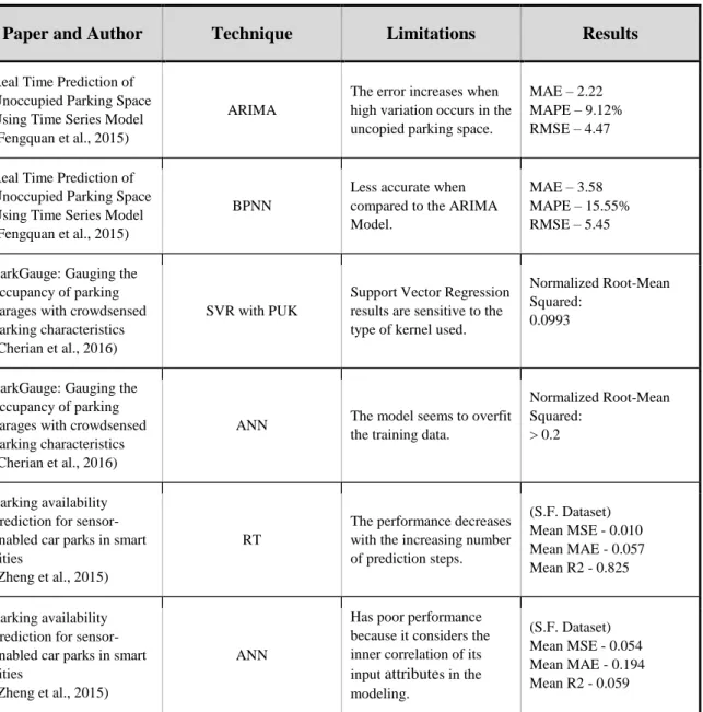
Paper and Author Technique Limitations Results
Real Time Prediction of Unoccupied Parking Space Using Time Series Model (Fengquan et al., 2015)
ARIMA
The error increases when high variation occurs in the uncopied parking space.
MAE – 2.22 MAPE – 9.12% RMSE – 4.47
Real Time Prediction of Unoccupied Parking Space Using Time Series Model (Fengquan et al., 2015)
BPNN
Less accurate when compared to the ARIMA Model.
MAE – 3.58 MAPE – 15.55% RMSE – 5.45
ParkGauge: Gauging the occupancy of parking garages with crowdsensed parking characteristics (Cherian et al., 2016)
SVR with PUK
Support Vector Regression results are sensitive to the type of kernel used.
Normalized Root-Mean Squared:
0.0993
ParkGauge: Gauging the occupancy of parking garages with crowdsensed parking characteristics (Cherian et al., 2016)
ANN The model seems to overfit
the training data.
Normalized Root-Mean Squared:
> 0.2
Parking availability prediction for sensor-enabled car parks in smart cities
(Zheng et al., 2015)
RT
The performance decreases with the increasing number of prediction steps. (S.F. Dataset) Mean MSE - 0.010 Mean MAE - 0.057 Mean R2 - 0.825 Parking availability prediction for sensor-enabled car parks in smart cities
(Zheng et al., 2015)
ANN
Has poor performance because it considers the inner correlation of its input attributes in the modeling.
(S.F. Dataset) Mean MSE - 0.054 Mean MAE - 0.194 Mean R2 - 0.059
Predicting Space Occupancy for Street Paid Parking 3. Case Study Background
3. Case Study Background
The following subchapters present the context of this study, starting by describing dataset context and collection method, analyzing what attributes and limitations are in it. The last subchapter describes the tools that analyzed the dataset, and the methods used to elaborate and evaluate the prediction models.
3.1 Dataset Context
The elaboration of this study is in the scope of the urban mobility and traffic management and associated with the MOBIN project application, namely by the use of the dataset made available through Empresa Municipal de Mobilidade e Estacionamento de Lisboa (EMEL), the main project partner to allow an initial exploration of the parking prediction tasks. This dataset contains 3 months of parking occupancy recorded by the on-street parking meters of two parking zones in the city of Lisbon.
3. Case Study Background Predicting Space Occupancy for Street Paid Parking
22
Figure 2 shows a map of Lisbon divided into parking zones, each one labeled with a number. EMEL administrates these zones, and their purpose is to establish the boundaries for the free parking permissions assigned to citizens. The dataset used contains parking data from the zone 1, Berna/Valbom, and zone 16, Campo Pequeno, both overlaid with red in Figure 2. It contains 3 months of parking registries collected between 01 September 2015 and 31 December 2015. The original dataset is a raw dump of the information registered in each multi-space parking meter, and they are operational 24 hours a day for 7 days in a week. Each registry corresponds to one parking payment. This is discussed in detail in chapter 4.
The parking zones are located in a central area of Lisbon, and these parking spaces are surrounded by residences, commerce, universities and event venues. These are heavy traffic areas, and consequently, the pollution reached levels above safe, having since 2011 the circulation restricted to vehicles that comply with the emission standard EURO 1.
Each parking zone contains one or more streets, and each street has several parking spaces that may be together or sparse through the street. The parking spaces may be parallel or angled, and they do not have individual parking meters, having instead a set of multi-space parking meters distributed along the street. Figure 3 shows a street with parking spaces and a multi-space parking meter.
Predicting Space Occupancy for Street Paid Parking 3. Case Study Background
After the driver parks the vehicle, he must search for the nearest parking meter and make the payment in advance. The amount to pay corresponds to the time that the driver wishes to park, and there is no refund if the driver leaves the parking earlier.
The parking meter emits a ticket after the payment indicating the park expiration time, and the driver must put this ticket visible on the vehicle dashboard. To increase the parking time a new payment has to be made, generating a new ticket. On the left of Figure 4 there is a detail view of a multi-space parking meter and on the right an example of a parking ticket in a dashboard.
Figure 4 – Detail of a multi-space parking meter and parking ticket
The parking paid time and price varies according to a color code assigned to each street as shown in Figure 5. A zone may have several different colors located at various places, and the paid time may have variations from street to street, having each street a sign indicating the color of that parking as shown in Figure 3.