Urban-rural relations in Europe
Urban-rural relations in Europe
Urban-rural relations in Europe
ESPON 1.1.2
ESPON 1.1.2
Final Report
Final Report
Edited by Christer Bengs & Kaisa Schmidt-Thomé
Edited by Christer Bengs & Kaisa Schmidt-Thomé
Centre for Urban and Regional Studies
Centre for Urban and Regional Studies
Helsinki University of Technology
Helsinki University of Technology
This report represents the final results of a research project conducted within the framework of the ESPON 2000-2006 programme, partly financed through the INTERREG programme.
The partnership behind the ESPON programme consists of the EU
Commission and the Member States of the EU25, plus Norway and Switzerland. Each partner is represented in the ESPON Monitoring Committee.
This report does not necessarily reflect the opinion of the members of the Monitoring Committee.
Information on the ESPON programme and projects can be found on
www.espon.lu”
The web side provides the possibility to download and examine the most recent document produced by finalised and ongoing ESPON projects.
ISBN number: 951-22-7244-X This basic report exists only in an electronic version.
© The ESPON Monitoring Committee and the partners of the projects mentioned. Printing, reproduction or quotation is authorized provided the source is acknowledged and a copy is forwarded to the ESPON Coordination Unit in
Foreword
This report presents the results of the project “Urban-rural relations in Europe”, which was conducted within the ESPON 2000-2006 Programme. The project was co-ordinated by the Centre for Urban and Regional Studies, Helsinki University of Technology, and included the following institutions (partners, subcontractors and observing partners) and persons:
• Centre for Urban and Regional Studies (CURS), Helsinki University of Technology (HUT):
Christer Bengs, Kaisa Schmidt-Thomé, Hanna Ristisuo, Marina Johansson, Anu Allt and Maëva Balay
• Centre for Urban Development and Environmental Management (CUDEM), Leeds Metropolitan University:
Simin Davoudi, Michelle Wishardt, Trevor Hart and Kevin Thomas • OTB Research Institute for Housing, Urban and Mobility Studies,
Technical University of Delft:
Wil Zonneveld, Dominic Stead and Bas Waterhout • TAURUS - Institute at the University of Trier:
Christian Muschwitz and Simone Reinhart
• TERSYN Agence Européenne Territoires et Synergies: Jacques Robert
• Centre for Geographical Studies (CEG) University of Lisbon:
Jorge Gaspar, Eduarda Marques da Costa, Ana Estevens, Mário Barroqueiro and Nuno Marques da Costa
• Regional Development and Policy Research Unit (RDPRU) University of Macedonia:
Lois Labrianidis and Stella Kyvelou
• Economic and Financial Studies and Quantitative Methods (Sefemeq), Faculty of Economics, University of Rome Tor Vergata:
Maria Prezioso, Nicola Lugeri and Alessandro Locatelli
• National Institute for Regional and Spatial Analysis (NIRSA), NUI Maynooth Jim Walsh and Jeanne Meldon
• Austrian Institute for Regional Studies and Spatial Planning (ÖIR): Friedrich Schindegger, Gabriele Tatzberger and Anton Hendrich • Nordregio: Jörg Neubauer
• Mcrit: Andreu Ulied and Laura Turró Bassols
• VÁTI, Hungarian Public Company for Regional Development and Town Planning: Erzsébet Visy
• Ljubljana Urban Institute (LUZ): Maja Simoneti
The report has a number of authors. They have based their contributions on the various working documents of the project. The editors, Christer Bengs and Kaisa Schmidt-Thomé, are responsible for the final selection of the material and for the possible contradictions with the original partner contributions. Selected working material from the various
The summary has been compiled by Christer Bengs & Kaisa Schmidt-Thomé.
The Chapter 1 has been written by Christer Bengs, except for subchapter 1.3, which has been written by Kaisa Schmidt-Thomé. The section of urban-rural functional relations draws heavily on the contribution of Dominic Stead as well as the section 1.3.1.Chapter 1.
The Chapter 2 is based on the Working Documents of the Workpackage 4, written by Simin Davoudi, Michelle Wishardt, Trevor Hart and Kevin Thomas (see also Annex 8 for links to material that is available online).
The Chapter 3 has been written by Christer Bengs. Jörg Neubauer has elaborated the statistics and maps on national definitions. Tomas Hanell has contributed in developing the methodology. Hanna Ristisuo has elaborated the statistics and maps on the interrelations of various criteria and the harmonised typology. Eduarda Marques da Costa has produced the factor analysis and Kaisa Schmidt-Thome has contributed comments all the way.
Chapter 4 has been written by Jim Walsh, Kaisa Schmidt-Thomé, Dominic Stead and
Eduarda Marques da Costa. The findings were summarized in 4.3 by Kaisa Schmidt-Thomé. The analysis is based on case studies (see Annex 7 for the authors), which are also
available online (see Annex 8 for the links). Chapter 5 has been written by Christer Bengs.
Chapter 6 has been compiled by Christer Bengs drawing on policy conclusions from the other chapters as well as various contributions of Jacques Robert, Simin Davoudi and Kaisa Schmidt-Thomé.
The Annexes have been compiled by Kaisa Schmidt-Thomé, Hanna Ristisuo and Maëva Balay, drawing partially on the Working Documents of the Workpackage 2, written by Simone Reinhart and Christian Muschwitz.
CURS wants to express its gratitude to all partners involved for a very pleasant and professional co-operation, to a number of ESPON projects that have always been eager to collaborate as well as to the Co-ordination Unit and the Commission for their great
assistance during the whole process. We also want to thank the national contact points, which have provided us with insightful comments.
The contents of this report are the responsibility of the authors and do not necessarily reflect the opinion of the ESPON Monitoring Committee.
CONTENT
Part One: Summary
Executive Summary 11
Main maps 29
Scientific summary 34
Report on networking 40
Report on further research issues and data gaps to overcome 42
Part Two: Results of the project
1 Spatial Europe 44
1.1 The spatial dimension 44
1.2 Urban Europe 46
1.2.1 Conceptual remarks 46
1.2.2 Theoretical remarks 50
1.2.3 Historical remarks 55
1.2.4 Functional integration and rank-size of urban centres in Europe 62
1.3 Rural Europe 67
1.3.1 Defining rural areas 68
1.3.2 Rural restructuring 77
1.3.3 Conclusions 85
1.4 Urban-rural relations 86
1.4.1 Conceptual remarks 86
1.4.2 European research on urban-rural relations 90
1.4.3 Governance and public interest 92
1.4.4 Partnership, public interest and policy recommendations 96
References 98
Appendix: Country-cases of urbanisation 104
2 Policies with relevance for urban-rural relations 117
2.1 Current EU policies affecting urban-rural relationships 117
2.1.1 Urban Policy 118
2.1.2 Agricultural and Rural Policy 120
2.1.3 Regional Policy 123
2.1.4 Community Initiatives 126
2.1.5 Article 10 Pilot Projects and Innovative Actions 131
2.1.6 Transport Policy 133
2.1.7 Environmental Policy 135
2.1.8 Spatial Policy 137
2.1.9 Summary 138
2.2 National policies affecting urban-rural relationships 139 2.2.1 The level of attention to urban-rural relations in national policies 141 2.2.2 Key themes and expected effects of the policies 144
2.3 Urban-rural initiatives in Europe 147
2.3.1 Primary focus, aims and activities of the initiative 148 2.3.2 The nature of the initiatives vs. urban-rural relationships 151
3 Typology of urban-rural characteristics 155
3.1 Introduction 155
3.2 National definitions of urban and rural 156
3.2.1 National criteria applied 156
3.2.2 Urban and rural population according to national criteria 157 3.2.3 National definitions compared to national averages 158
3.2.4 Typology based on national definitions 159
3.3 Factors of urban-rural relations 160
3.3.1 Methodological considerations 160
3.3.2 Choice of criteria: parallel factor analysis 160
3.3.3 Urban and rural characteristics 162
3.3.4 Correlations among criteria 165
3.3.5 Economic performance 167
3.3.6 Population change 168
3.3.7 Typology of development prospects 169
3.4 The harmonised urban-rural typology 169
3.4.1 High or low urban influence 170
3.4.2 High, medium or low human intervention 171
3.4.3 The six regional types of the typology 171
3.4.4 Overall distribution of NUTS3 areas, land, population and wealth 172
3.4.5 Population changes 1995-99 173
3.4.6 GDPpps per capita and changes 1995-99 173
3.4.7 Lagging regions 174
3.4.8 Accessibility to transport 175
3.4.9 Accessibility to knowledge 175
3.4.10 Tourism 176
3.4.11 Land use efficiency 176
3.5 National definitions and the harmonised typology 176 3.6 National applications of the harmonised typology 177
3.7 Summary 178
3.7.1 National definitions 179
3.7.2 Multivariate statistical analysis 179
3.7.3 Indicators of urban-rural characteristics 180
3.7.4 The harmonised typology 182
3.7.5 National definitions and harmonised typology compared 184 3.7.6 National applications of the harmonised typology 185
3.8 Policy implications 185
Maps, graphs and tables referred to in chapter 3
References 186
4 Socio-economic diversification
and interconnectedness of urban and rural areas 188
4.1 Socio-economic diversification and urban-rural relations 191 4.1.1 Comparison of country level case studies: France and Ireland 191
4.1.2 Findings from regional cased studies 196
4.2 Interconnectedness of urban and rural areas 200
4.2.1 Commuter catchments 200
4.2.2 The causes and effects of migration between urban and rural areas 203 4.2.3 Interconnections of functions in urban and rural areas 207
4.2.4 Changes in the use of resources 209
4.3. Summary of the findings of Chapter 4.1 and 4.2 211
References 216 Appendix“Blue City” in North East Groningen, the Netherlands 217
5 Land use: development and profitability 218
5.1 Introduction 218
5.2 Land and its profitability 220
5.2.1 Value of land 221
5.2.2 Unearned profits 222
5.2.3 Supply and demand 223
5.2.4 Conclusions 224
5.3 Spatial development and land use planning 224
5.3.1 The role of land use planning 225
5.3.2 Planning theory 228
5.3.3 Conclusions 229
5.4 Effects of land speculation: urban sprawl and urban containment 230
5.4.1 Urban sprawl 230
5.4.2 Urban containment 233
5.4.3 Conclusions 237
5.5 National cases: development and property markets in France,
Germany, Italy and the UK 238
5.5.1 France 238
5.5.2 Germany 239
5.5.3 Italy 240
5.5.4 The UK 241
5.5.5 Conclusions 242
5.6 Private-public partnership and urban sprawl: the Helsinki region 243
5.6.1 The theme 243
5.6.2 The socio-economical context 244
5.6.3 The policy context 245
5.6.4 The region 245
5.6.5 The dominance of the supply side 246
5.6.6 Contract based development 248
5.6.7 Speculative development 250
5.6.8 The rationale of contract based development 251
5.6.9 Conclusions 252
5.7 Public-private partnership and structural confinement:
the Stockholm region 253
5.7.1 Theme 253
5.7.2 The socio-economic context 254
5.7.3 The policy context 254
5.7.4 The region 254 5.7.5 Regional enlargement 256 5.7.6 Conclusions 256 5.8 Conclusions 258 References 261 6 Policy recommendations 265 6.1 Introduction 265
6.2 The policy context of the EU 266
6.4 Recommendations 272
6.4.1 Structural policies of the EU 273
6.4.2 Sectoral policies of the EU 274
6.4.3 Functional urban-rural relations 275
6.4.4 Structural urban-rural relations 277
Part Three: Annexes
Annex 1: List of maps, tables and graphs
Annex 2: List of indicators developed and datasets provided to the ESPON Database Annex 3: List of missing data
Annex 4: List of references, including the use of results from projects outside the ESPON programme
Annex 5: List of publications of the TPG members resulting from the research undertaken so far
Annex 6: Indication of performance indicators achieved Annex 7: Case studies of the project in brief
Annex 8: Working document and questionnaire of WP 4: Policy recommendations Annex 9: List of working material available online
4
Socio-economic diversification and
interconnectedness of urban and rural areas
This chapter extends the analysis of urban-rural relationships by the use of case studies. Through these studies more detailed information on processes and relevant policy initiatives are presented which complements the analysis undertaken at NUTS3 level. As urban-rural relations do not coincide with administrative boundary systems, analyses based on datasets organised according to such systems can only provide limited insights into the processes underlying and shaping urban-rural relationships.
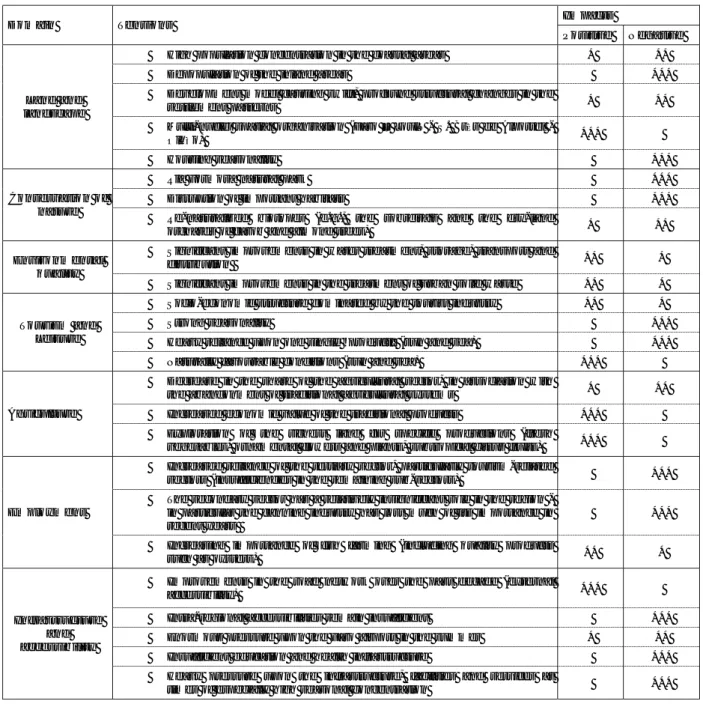
The case studies are representative of the different categories identified in the typology of urban-rural characteristics (presented in Chapter 3) and they address three different themes:
·
socio-economic diversification,·
territorial interdependence and·
land use profitability.The first two deal mainly with functional relations while the third deals primarily with structural and power relations. Table 4.1 summarises the location of each case study in a matrix based on the area types and the three themes. The findings of the two first case study themes are presented in the subchapters 4.1 and 4.2 – and summarized in 4.3. The questions of land-use profitability and urban sprawl are dealt with in Chapter 5. The case studies were prepared by project partners and some subcontractors, as well as by the two observing partners1. The case studies can be accessed at the website2 of the
project. Some key features of the cases are presented in Annex 7.
The case studies undertaken for this project build on the research undertaken for the Study Programme on European Spatial Planning (SPESP)3. The final report from the
SPESP project identified several dimensions of economic, socio-cultural and political transitions which were considered to be underpinning changes in contemporary urban-rural relationships. These are summarised in Table 4.2.
1 see Annex 7 for the names and institutes of the authors. 2 http://www.hut.fi/Units/Separate/YTK/research/ur/cases/. 3 SPESP 2000.
Socio-economic diversification Territorial interdependence Land use profitability Functional relations Structural relations Case study areas services,
production of tangible goods education/ knowledge production of intangible goods flows of people, commuting amenities (water, waste) land vs. population land prices, exploitation systems 1 Urban, high human intervention NL: Randstad & Green Heart + NL: Blue City D: Berlin, Barnim IT: Rome FI: Helsinki SE: Stockholm ES: St.Miquel de B. X X X X X X X X X X X 2 Urban, medium human intervention France Ireland X X X X 3 Urban, low human intervention France X X 4 Rural, high human intervention HU: Gyor X X X 5 Rural, medium human intervention UK: Ryedale FR: Albi IR: County Meath
X X X X X X X 6 Rural, low human intervention PT: Figueiro PT: Algarve SI: Dolenjska X X X X X X Table 4.1
Elaborated case studies according to type of area and main themes.
The SPESP case studies highlighted the need for new perspectives on urban-rural relationships with more attention to networking between places, more emphasis on the ‘drivers’ of the new relationships at different territorial scales and greater attention to policies and strategies that can facilitate new territorial relations. Furthermore, as a sum-mary of the case study work undertake, a list of key urban-rural relationships was identified:
·
home-work relationships·
central place relationships·
relationships between metropolitan areas and urban centres in rural and intermediate areas·
relationships between rural and urban enterprises·
rural areas as consumption areas for urban dwellers·
rural areas as open spaces for urban areas·
rural areas as carriers of urban infrastructureTheme / driver Trends Implications 1) Changing patterns of
economic activity
Industries are increasingly open to competition on a global scale.
Traditional economic linkages between rural areas and nearby towns are weakened. The significance of endogenous initiatives and new partnerships is upgraded.
Some activities are increasingly footloose and can avoid congested metropolitan areas. Vs. Some activities depend on the diversified milieus of the metropolises.
Territories find themselves positioned in a range of spatially-differentiated economic relations.
Growing concern with soft infrastructure investment in training, education, research and institution building.
Also rural towns need to find innovative approaches to develop new activities and partnerships.
2) Dynamics of innovation and learning
Territories able to remain competitive need to have local cultures which promote continual adjustment and innovation. In some activities information can be codified for production over distances – in others the innovation is bound up with tacit knowledge resources.
Relation between innovation capability and territory, and between urban and rural areas, is not straightforward.
It is difficult to avoid promoting spatial unevenness when fostering innovation capacity.
The critical role for territorial government is to promote the development of hard and soft infrastructures which promote learning capacity both in urban and rural areas. 3) Changing demographic
profile
The population is ageing and fertility rates fall. The participation of women in the labour markets increases. The society is increasingly mobile.
Certain metropolitan “escalator” regions continue to draw attraction with their diversity. In rural areas also minor flows of active population can be significant. 4) Social change and
differentiating lifestyles
The socio-spatial relations are increasingly diversified and fine-grained.
The mosaic of affluence and poverty is manifest in both urban and rural areas. The questions of lifestyle differentiation and
consumption patterns have an important role in the economy.
Various urban and rural localities with special qualities (landscape, services) start to attract certain groups (eg. the elderly).
5) New bases for culture, identity and citizenship
Successful territories should be able to provide both “safety-assets” and “opportunity assets”.
Many rural areas and small towns lack “opportunity assets”.
Design of place-identities (both “happy as sleepy” and “vital and dangerous”) becomes crucial.
New kind of professionalism within spatial planning needed.
6) Environmental sustainability as motivating concept
Need to address the environmental degradation is becoming more and more evident. Policies aiming at sustainability are being promoted.
The distinction between urban and rural areas are broken apart. Ecosystemic and biospheric ways of conceptualising territorial linkages come to the fore.
7) Challenge of government and policy-making.
Shift from rule-bound top-down government to multi-actor and multi-level governance is taking place.
The capacity of the sub-national government is crucial in building the urban-rural bridges.
Table 4.2
Key drivers of changes in urban-rural relationships
In the SPESP these relationships were given no specific geographical reference – they were not related to any spatial context but were rather floating in space. The current project highlights the importance of the long-term trends and ruptures in urbanisation tendencies in various parts of Europe, referring to the differential urbanisation theory. The purpose of this chapter is thus to revise the SPESP findings – to locate the various key trends in the differentiated urbanisation patterns of Europe and to identify the key tendencies behind the urban-rural settings that seem to be of importance from the
perspective of spatial policy making. This then leads to the discussion whether the ESDP policy goals can be promoted through operationalising them in the form of concrete urban-rural sensitive measures.
4.1
Socio-economic diversification and urban-rural relations
As discussed in Chapter 1, the restructuring of both urban and rural areas result from complex interplays of global/European, national and regional/local factors. Here the purpose is to draw together findings concerning socio-economic diversification and the implications of the restructuring process for urban-rural relations. Firstly, two national level case studies (France and Ireland) are presented and compared with each other. Then findings from the regional level case studies are discussed, using examples of the most illustrative cases concerning the socio-economic questions. The findings of the two themes 4.1 and 4.2 are presented jointly in chapter 4.3.
4.1.1 Comparison of country level case studies: France and Ireland
France
In France, a new classification of urban and rural areas that takes account of their interactions was introduced in 1996/97. Two broad territorial categories were introduced: (a) areas with dominating urban character and (b) areas with dominating rural character. Each broad category is further sub-divided into a total of eight area types extending from “urban poles” to “isolated rural areas”. Over the past two decades, significant contrasts have emerged in the demographic and labour market performances of the different area types. Urban poles experienced modest gains in population mainly because of negative migration flows while suburban municipalities that comprise peri-urban areas had significant gains in population mainly due to net in-migration. Within rural areas the main contrast is between ‘rural areas under slight urban influence’ and ‘isolated rural areas’ where population is declining. These adjustments according to the different area types have resulted in pronounced regional contrasts. The highest levels of population and employment increase occur in the west and south/southeast, which can be contrasted with declines in an axis extending from the northeast to the southwest, and also significant declines in older industrial areas especially in the northwest.
Detailed statistical analysis of the demographic and labour market performances of the different components of the urban system demonstrate the importance of socio-economic diversification trends. For example, industrial restructuring associated with the decline of traditional sectors has resulted in net out-migration and high unemployment in approximately 20 medium sized towns mainly in the northeast. The largest cities with a strong orientation to new economic sectors and significant administrative functions have experienced net-outmigration and low levels of employment increase. By contrast, medium sized towns with significant public functions and especially those located in the south of the country, had very high net-in migration and employment gains. Also there are numerous small towns in mainly coastal and mountain areas that are particularly attractive for retired people and for tourists. These areas have had above average gains in population and employment.
In 1999, there were 10.6 million persons (18 % of the total population) residing in the ‘areas with dominating rural character’. Net in-migration is the dominant demographic
factor in most of the rural areas including both those that are near urban centres and those that are isolated. Medium and small towns continue to be the main providers of public and private services for rural areas.
The trends noted for France are due to several factors that include the tendency for high level personal and business services to concentrate in cities, the deconcentration of industrial employment and lower level public services from urban to rural areas, and the increasing role of rural tourism in distinctive parts of the country.
A typology of the countryside (Map 4.1) has been developed, which identifies three basic categories:
·
The countryside of cities·
Multifunctional and economically diversified countryside,·
Declining countryside.Map 4.1: Typology of the French rural areas
(Source: Quelle France rurale pour 2020? DATAR 2003)
(Excluded from the typology)
Countryside of cities
Suburban areas with dom inating residential functions
Dense, residential and productive rur al areas
Declining countryside Urban areas
Countryside with ageing population and agricultural economy
Countryside with declining traditional industries
Multifunctional and economically diversified countryside
Rural ar eas striving towards multi-functionality
Rural ar eas with economy based on tourism
Rural areas attractive for r esidential functions and and enterpr ises
Small rural towns (Excluded from the typology)
Countryside of cities
Suburban areas with dom inating residential functions
Dense, residential and productive rur al areas
Declining countryside Urban areas
Countryside with ageing population and agricultural economy
Countryside with declining traditional industries
Multifunctional and economically diversified countryside
Rural ar eas striving towards multi-functionality
Rural ar eas with economy based on tourism
Rural areas attractive for r esidential functions and and enterpr ises
Small rural towns
Different types of urban-rural relations are associated with each category. The ‘country-side of cities’ consists of two sub-categories that represent different types of urban-rural relations. The first sub-category includes the first suburban ring of large and medium size urban areas, which are very densely populated and are continuing to grow rapidly as a result of in-migration. Many of the workers living in these areas are reliant on car-based commuting to work in the neighbouring urban centres. By contrast, in the outer suburban rings of the large and medium sized cities population densities are lower and a greater share of employment is in endogenous activities. Thus the urban-rural
interactions are less intense in terms of daily commuting, compared to those of the residents of the first suburban ring, but they may be more intense in terms of accessing deconcentrated public and private services.
The ‘multifunctional and economically diversified countryside’ can also be sub-divided into two sub-categories on the basis of the level of multifunctionality already achieved. For example, in the Mediterranean regions and, to a lesser extent, along the Atlantic coast and in the southwest there are many rural areas that are attractive for residential functions, tourism and enterprises. The dominant urban-rural relationship in these areas concerns the migration of retired people from cities as well as the interactions with medium size and large cities for the provision of services.
There are many rural areas, especially in the west, where primary agriculture and agri-food processing are still very important in terms of employment. Manufacturing employment is mostly located in small towns and is generally in decline. These areas are undergoing a rapid diversification towards mainly urban based tertiary activities. In these rural areas the dominant rural urban relations are generally over short distances to access services and employment opportunities.
The ‘declining countryside’ areas combine three handicaps: low population density, declining populations and mono-activities. Two sub-regions can be identified. The first are the mountain areas and hilly landscapes that are characterised by very low population density and an ageing population that is still heavily dependent on low productivity agriculture. Urban-rural relations in these areas are mainly concerned with the provision of basic services.
The second sub-category are rural areas with declining traditional industries and are found mainly in the northern half of the country. Employment has been heavily concentrated in traditional manufacturing sectors that are now in decline. The total population is ageing and declining due to natural decrease and net out migration. Urban-rural relations are mainly concerned with commuter flows between the countryside and small and medium sized towns in addition to interactions for access to basic services. In summary, recent experience in France points to the emergence of new forms of urban-rural relations in the 1990s. The traditional dualism between urban and urban-rural areas is being replaced in response to increasing economic diversification. New economic bases are now emerging related to residential functions and recreational activities. The growth of large agglomerations has slowed and a number of small and medium sized towns as well as rural areas have found new sources of prosperity.
Ireland
The Irish case study exemplifies many trends that are similar to those described for France. However, there are important contextual differences not the least being that the share of the population living in rural areas in Ireland, after allowing for differences in definition, is more than twice the level in France. In many respects Ireland is more akin to a region in France. Another significant contrast between Ireland and France is that since the early 1990s Ireland has undergone a fundamental socio-economic transformation. Unlike most other regions in Europe the economy of Ireland is exceptionally open and, therefore, the location patterns of enterprise and employment are disproportionately influenced by globalisation considerations. The socio-economic transformation is driven by several factors but for this analysis of urban-rural relations the most notable are, on
the one hand, the very high reliance on foreign direct investment in high value added sectors, which has been mostly concentrated in the larger urban centres and, on the other hand, the very significant decline in the role of primary agriculture and other traditional industries, especially in rural areas.
The socio-economic transformation since the early 1990s has significantly altered the traditional patterns of urban-rural relations. Distinctive peri-urban zones are evident around all of the major centres of population. More significantly the geographical extent of these zones has expanded since the mid 1990s in response to several factors. The single most important driver has probably been the cost of housing in the larger urban centres, especially Dublin. In a context of a very rapidly increasing work force and simultaneously changes in household structures (the total number of households increased much more quickly than the population) the supply of housing was unable to keep pace with demand, which resulted in spiralling house prices. In response increasing numbers of people opted for housing at very considerable distances from their places of employment. The deconcentration of population has been facilitated by increased levels of car ownership and by improvements in the road and commuter rail infrastructures. The dominant types of rural-urban relations in the expanding peri-urban areas are related to commuter flows and also longer distance movements for higher level personal and public services. There are also several locations on the fringes of the greater Dublin commuting hinterland that are in high demand for second homes and holiday homes, and thereby constituting another new type of rural urban relation, especially in the southeast of Ireland.
Beyond the expanded peri-urban zones approximately 14 % of the population reside at very low densities (average of 15 persons per sq km) in rural areas that cover just over half of the country. In these areas characterised by high dependence on low productivity agriculture, a weak urban system and low quality transport infrastructure there has been a long history of net out migration and population decline. Consequently rural urban relations are more localised and mainly confined to travel for low level public and private services as well as short distance commuting. However, there is one form of longer distance rural urban interaction that has broader and longer term consequences. It relates to movement of school leavers to universities and other third level educational institutions, which are mostly based in the larger urban centres. The majority of students from rural areas remain in the urban areas after they graduate into the labour market.
Finally, there are some relatively remote rural areas that have experienced a significant transformation in the 1990s. These are usually areas of outstanding natural beauty where strong tourism and recreation related economies have developed. These areas have also attracted large numbers of in-migrants, many of whom have set up new enterprises that are catering for markets that are frequently in very distant urban centres. Between 1991 and 2002 the total population of these rural areas, which to a large extent share the characteristics of new consumption spaces, had the highest levels of population and employment increase. The rural urban relations in these areas are frequently over long distances and take the form of visitor flows, migrant labour from urban areas outside of Ireland, and movements of high quality craft and other products to national and inter-national markets. At the same time for many of the indigenous traditional residents of these areas their urban-rural relations are mostly very local for access to basic services. One of the consequences of high levels of tourism related activities is a high demand for second homes, which increases the level of competition faced by local home buyers.
Rural Typology
Rural Typology
Urban Areas
Urban Areas
Peri-urban
Peri-urban
Very Strong
agriculture
Very Strong
agriculture
Strong Agricultural
Areas in need of
adjustment
Strong Agricultural
Areas in need of
adjustment
Structurally Weak
areas
Structurally Weak
areas
Marginal areas
Marginal areas
High Amenity
Consumption Spaces
High Amenity
Consumption Spaces
Motorway Secondary PrimaryThe policy responses to improving urban-rural relations in Ireland are contained in the White Paper on Rural Development and the National Spatial Strategy, which has recently been augmented by Strategic Planning Guidelines for each region. Considerable emphasis is placed on strengthening linkages between rural and urban areas and on developing local and regional capacities through a network of Gateways and Hub towns. In response to widespread public controversy concerning housing in the countryside, new planning guidelines have been prepared.
In summary, the high economic growth rates of globalising Dublin have contributed to the further supremacy of the capital. Around Dublin the urbanisation pressure is very high, resulting from the rapid increase of land prices in urban areas together with perception of enhanced quality of life in rural areas.
The development of rural population over recent decades shows an increasingly complex pattern. Declines are evident in the most marginal rural areas and increases are confined mostly to the commuting hinterlands of the larger urban centres. Increase is also occurring in some coastal zones where there has been evidence of greater economic diversification particularly in the tourism sector. The increase in consumption of leisure and tourism related services has given some rural areas new roles as consumption spaces that are vitally linked to often-distant urban centres. The areas with traditional agricultural sector
Map 4.2:
have been prone to decline. Efforts to compensate the loss of agricultural employment have resulted in increasing reliance on either farm based diversification or off-farm employment. These adjustments have taken place especially in the rural areas where linkages to urban areas can be established.
Summary
A distinction can be made between those new urban-rural relations that correspond with more or less irreversible flows and those which correspond to daily, weekly or more
regular mobility between urban and rural areas. The first category refers to flows associated
with out-migration from the cities to the countryside, and relocation of productive activities from large urban centres to smaller ones or to the suburban areas, and also to more distant rural areas that offer the prospects of a higher quality of life. The second category involves journeys to work, plus access to services and recreational facilities, motivated by perceptions of the attractiveness of places and the quality of life.
In both France and Ireland the long and short terms interactions correspond with broad classes of rural areas in the following way:
– Peri-urban zones: Interaction on the long term is about in-migration of both young families and retired population. In the scale of Ireland this concerns especially the peri-urban zone of major cities, whereas in France also most medium-sized cities have such zones. In the Dublin hinterland there is also an increasing demand for second homes and holiday homes. In terms of short term interaction the key question is the intense commuting. Also higher level personal and public services bring about movements over long distances.
– Low-density rural areas: What comes to long-term interaction, the movement of school-leavers to urban areas with higher level educational institutions is significant. The daily urban-rural relations are more localised , travelling for public and private services as well as short distance commuting. The pattern will be affected if the shift from the high dependency on low productivity agriculture towards farm based diversification of off-farm employment proceeds.
– Remote areas with natural beauty & Rural areas in coastal regions: Long-terms movements include in-migration to the new consumption spaces and establishment of new enterprises catering non-local markets. A special feature is the in-migration of retired people. Short-term movements include frequent flows of visitors, migrant labour and products to and from major cities or abroad. However, most indigenous traditional residents remain in the sphere of very local urban-rural interaction. It seems that several key features of the socio-economic restructuring are similar but the pace of change is more rapid in Ireland, where the viability of major centres is highly influenced by global players of the economy and where the primary agriculture is experiencing a very significant decline. In France also many medium-sized cities prosper, especially if they are located in attractive regions.
4.1.2 Findings from regional cased studies
Randstad and the Green Heart
The case study of the urban rural relationships in the Randstad and the Green Heart illustrates the role of spatial planning in managing the increasing pressures on the Green
Heart. In contrast to most of the case studies there are no parts of the Green Heart that may be regarded as inaccessible; it is estimated that 95 % of the land area is within a ten minute drive from a motorway. Improvements in accessibility coupled with a desire among a large segment of the population for rural living has placed the Green Heart under considerable pressures for many years. Since the 1960s planning strategies have sought to promote different forms of compact urbanisation while strongly supporting the preservation of rural open spaces. In 1977 the policy document on rural areas extended the role of the Green Heart from its primary function as an agriculture resource to also include the roles of leisure pursuits and nature conservation. Later plans highlighted the potential for functions such as tourism and recreation along with nature protection. One of the consequences of improvements in transport infrastructure is that there has been some relocation of employment to the edges of the cities, often to sites near motorway junctions, and also the emergence of the Randstad as almost a single regional labour market for some professions. Associated with these trends are high levels of commuting within the Randstad and also into and out of the polycentric zone enclosing the Green-heart. The case study illustrates that even a long term commitment to spatial planning and managing the tensions between urban and rural areas is difficult in a context of high densities of population.
The Algarve region in Southern Portugal
This case study illustrates very well the outcomes in respect of urban-rural relations from local economic restructuring resulting from increasing levels of international tourism in southern Europe. Analysis of demographic trends since the 1980s reveals significant contrasts between ‘repulsive areas’ (mostly inland mountainous areas) and the coastal areas. It is also evident that improvements in transport infrastructure and investments in selected seaside resorts beyond the core coastal areas are helping to revitalise some rural areas that were previously in decline.
There are several effects associated with the high reliance on tourism. The role of agri-culture is greatly diminished due to the dynamics of local labour markets which draw rural labour into urban based tourism services, and also due to the diminishing productivity of a residual ageing rural workforce, especially in the inland areas. Thus the traditional primary production based urban-rural relations have been severely reduced and replaced by new types of relations such as increasing supply and demand for seasonal homes. The role of the larger urban centres as the economic core areas and the principal employment locations is confirmed by data on commuting. These data point to the commuter hinterlands becoming more extensive and also to increasing levels of interaction between the urban centres contributing to the formation of urban axes as along the coast.
There are several effects associated with the high reliance on tourism. The role of agriculture is greatly diminished due to the dynamics of local labour markets which draw rural labour into urban based tourism services, and also due to the diminishing productivity of a residual ageing rural workforce, especially in the inland areas. Thus the traditional communities in these areas and weakens the capacity to provide urban based services to dispersed rural dwellers. By contrast, in the rapidly expanding areas associated with the influx of international tourists the landuse pressures are unsustainable in some cases. Already there is evidence that the process of urban expansion into formerly rural areas has brought about the irreversible destruction of important habitats. The seasonality of tourism gives rise to particular problems in relation to water and sewerage infrastructure
Ryedale in North Yorkshire
This cased study examines the effects of counter-urbanisation on the ‘remote rural’ district of Ryedale in North Yorkshire. The area is one of low density where the population of 51,000 has been increasing rapidly over the past twenty years. Net in-migration has been the dominant influence on the population dynamics, though much of the in-migration consists of elderly people. There is an on-going transition from agriculture and manu-facturing towards services. In contrast to some other rural areas experiencing counter-urbanisation the majority of the service jobs in Ryedale are in low paid part-time services. capacity that impact on both the visitors and the indigenous population. A summary of the functional and structural tensions in the area is contained in Table 4.3.
Table 4.3: Functional and structural tensions: impacts on urban-rural relations
(Based on: CCDR-ALGARVE 2004 and AMAL 1999)
Impacts Domain Tensions
Positive Negative
x High population concentration in the coastal areas * **
x Depopulation of the inland areas ***
x Development model causing swift, profound structural changes in the
settlement patterns * **
x Multi-nuclei spatial organisation (Faro – Loulé - S. Brás de Alportel -
Olhão) ***
Land and landscape
x Housing seasonality ***
x Ria Formosa natural park ***
x Disruption of important habitats ***
Conservation of
nature x Re-naturalized biotopes (e.g., the sobreirais and the dry-land
orchards of carob and almond trees) * **
x Significant improvements in water treatment, storage, transport and
distribution ** *
Environmental quality
x Significant improvements in the treatment of urban solid waste ** * x Socio-economic structure dominated by the tourist industry ** *
x Strong seasonality ***
x Heavy reliance upon one single “product” (sun and sea) ***
Tourism and Leisure
x Naturally favourable conditions (sun and sea) *** x Decrease in the share of the agricultural sector, in association with
the abandonment of traditional agricultural systems * ** x Increased economic value of the traditional products ***
Agriculture
x Exploration of the richest land for specific productions (fresh
vegetables, ornamental flowers and plants, subtropical citrus fruits) *** x Increased reliance of the tertiary sector, particularly tourism-related
sectors (insufficiencies in the remaining sub-sectors) *** x The secondary sector has a relatively insignificant role in the region -
in particular the canning industry has lost much of its importance in recent years
***
Employment
x Increasing importance of fish farming (including quality products
such as oysters) ** *
x Improvements in the road network over the past decade (external
accessibility) ***
x Intra-regional accessibilities remain insufficient *** x Enormous pressure upon the Faro airport in the summer * ** x Insufficient education and health infrastructure ***
Infrastructure and accessibility
x Heavy pressure upon the infrastructure, facilities and services at
One of the most notable features of Ryedale is the increasing demand for houses by in-migrants from the larger urban centres in the region. There is also an increasing demand for rural houses as second and holiday homes. The increased demand for second homes can lead to a number of undesirable outcomes such as local housing crises with members of the local population having to participate in more competitive property markets, and also in some areas further decline in the number of shops and other services as holiday / second home owners tend to make less use of local providers and since they are present in the area for only parts of the year. The evidence from north Yorkshire is that rural service providers are benefiting less than they might have expected from urban-rural migration.
The trends described in Ryedale are the outcome of several factors including more people willing to undertake car based longer journeys to work; the decline in job opportunities in rural areas and the increasing need for off-farm employment for members of farm households; planning restrictions on greenfield sites which encourages housing supply in the smaller urban centres; and for some the lure of the countryside as a venue for a higher quality of lifestyle.
The policy implications arising from the experience in North Yorkshire include the need for closer integration of rural and urban policies and for greater co-ordination of local and regional plans. In response to the local housing crises special measures have been introduced to selectively permit development of protected green field sites subject to a number of conditions. This is an attempt to encourage younger and lower income local people to remain in the area and to counteract the effects of urban-rural migration.
Region of Gyor in Hungary
The Region of Gyor in Hungary exemplifies the challenges for rural urban relations, and in particular the consequences of the political transitions since the early 1990s, in the former socialist countries of Eastern Europe. Pre 1990 economic development was mainly lead by state controlled heavy industries, which were located in the urban areas. The labour intensive growth of heavy industries involved the concentration of people in large housing estates in the cities. Much of the industrial labour force was made up of migrants from rural areas. Apart from the immediate hinterland of Budapest the populations of the rural settlements throughout Hungary were in decline.
Since 1991 there have been fundamental changes in the management of the economy and also in the distribution of powers between local and central administrations. As a result there have been some very significant changes in population distribution. Most notably there has been a large increase in the volume of out-migration from the larger urban industrial centres to the surrounding rural areas. Most of those moving were escaping from the gloomy housing conditions and the deteriorating inner cities. Others left the cities because they had lost their employment in the course of the industrial restructuring and could no longer afford the increasing costs of privatised housing. The increased level of political independence given to local governments in relation to land management made it more difficult to achieve co-operation in spatial planning.
Gyor is the largest city in the West-Transdanubian region and has been a major industrial centre. While the food and textile sectors have declined it remains a strong centre for the manufacturing of trucks. Since the late 1990s there has been a shift towards a knowledge based economy with the establishment of three major research centres. Gyor is also
favoured by its strategic location in the growth corridor connecting Budapest and Vienna and it is also a gateway city near the northwestern national border of Hungary.
In 2001 the municipalities in the region surrounding Gyor formed an association to promote co-operation between the urban and rural areas. Several new firms have been established in the municipalities neighbouring Gyor and there is a growing demand for housing in these districts. The housing market is also distorted by increasing levels of speculative (foreign) investment in property leading to an escalation in land prices.
Population in the neighbouring municipalities is increasing mainly due to in migration and approximately 70 % of the employees are commuting to work in the urban region of Gyor. There are also significant counterflows of workers on a daily basis as many urban employees work in the firms located in the hinterland, many of which are linked to the industries in the city. The relocation of some employment outside the city and the new patterns of migration have altered the traditional socio-economic divisions between the urban and rural areas leading to a convergence in socio-economic profiles. While the nature of urban-rural relations has changed the intensity of urban-rural integration is less than it might be due to deficiencies in the transportation systems and networks.
Summary
The link between global-local relations and urban-rural relations becomes highlighted also in several regional case studies. Especially the role played by international tourism in socio-economic restructuring of the Algarve region has had rather drastic urban-rural implications. The concentration of population in the multi-poled coastal zone on the cost of the more continental, rural areas has been rapid. If the hinterlands are to benefit from the tourist flows, their service providers must form alliances with the service providers in the major urban agglomerations and holiday resorts. The overcrowding facing the south may turn to the advantage of the north.
The role of leisure time is of increasing significance in the restructuring of the economy. Access to consumption spaces is an important aspect from the perspective of urban-rural relations. High quality environments are as magnets not only for residents but also for enterprises. However, the regional cases tell still more about relocations of enterprises to the outer rings of urban agglomerations than about moving to the more remote country-side. In this respect the decisions related to infrastructure investments play of decisive role.
4.2
Interconnectedness of urban and rural areas
4.2.1 Commuter catchments
The increasing reach of cities and towns into their hinterland is the consequence of a range of factors that are similar in most if not all of the case studies. Factors include the increasing ownership and use of the car, the development of new transport infra-structure, differences between urban and rural property prices, changes in information and communication technology (ICT), changes in the economy and the labour market, and environmental and quality of life factors (some of these factors are discussed in more detail in section 4.2.2) These factors have all contributed to trends in suburbanisation, periurbanisation and ‘rurbanisation’ and have led to the enlargement of functional urban regions and the increasing functional interdependence of urban and rural areas within
those regions. For many residents of rural areas without access to a car, employment opportunities have declined.
In 1850 the Green Heart (NL), was still difficult to cross and most new infrastructure was built around it. Since then, this picture has changed and a substantial amount of development has taken place, including housing, industry and road infrastructure. By the end of the 20th century, the Green Heart is no longer an inaccessible part of the country: more than 95 % of the land areas of the Green Heart was within a 10-minute drive from a motorway. During the 20th century, the relatively isolated position of the villages and towns within the Green Heart was replaced by high accessibility, with important consequences for urbanisation and development pressures. It meant for example that during the 20th century the Green Heart became a highly desirable place to live within reasonably close proximity to the Randstad’s cities.
In terms of accessibility to employment in the area, it has been reported4 that the number
of jobs within a 15-minute commute is highest in the Randstad’s urban centres: Amster-dam, RotterAmster-dam, the Hague and Utrecht. However, this picture changes when a longer commuting time is considered. The number of jobs within reach of a 30-minute commute is highest in suburban areas between the large urban centres. And within a 45-minute commute, the number of jobs within reach is quite similar for almost all parts of the Randstad, including the Green Heart. This leads van Ham et al to conclude that the Randstad is close to being a single regional labour market for some professions. Consequently, the Green Heart not only offers a pleasant residential environment, it provides a very attractive and convenient location for people who want to maximise their opportunities in the labour market, particularly those in higher income groups (long distance commuting is obviously less attractive for lower income groups). In addition, accessibility is likely to become more dependent on information and communication technology (ICT) for a growing group of people. As new developments in ICT take place, new possibilities for working and living at a distance may open up for an increasing
4 van Ham et al 2001.
Map 4.3:
Accessibility to jobs within the Randstad (Source: van Ham et al 2001).
(a) jobs within a 15-minute commute
(b) jobs within a 30-minute commute
(c) jobs within a 45-minute commute
number of people, with likely consequences for greater land use pressures on rural areas such as the Green Heart and further spatial fragmentation.
Another study5 suggests that although commuting time for residents of the Green Heart
did not change very substantially between 1980 and 1990, the mode of transport did. In 1980, 55 % of commuting journeys were car-based and ten years later 65 % of commuting journeys were by car. During the same period, the proportion of travel-to-work journeys by public transport decreased from 12 % to 7 % and the proportion of journeys by foot decreased from 4 % to 2 % (ibid.). The use of the bicycle for commuting journeys remained fairly unchanged between 1980 and 1990. Commuting trends of residents in the four main cities in the Randstad during this period were quite different to the situation in the Green Heart.
In an attempt to reinforce relations with the Barcelona Metropolitan Region (BMR) by constructing new roads and introducing of a faster train service, the case study of Sant Miquel de Balenyà (ES) has experienced the suburbanisation of population and employment. Similar trends can also be seen in the cases of Berlin and Barnim (DE). In Gyõr-Moson-Sopron (HU), suburbanisation and car commuting has increased whilst public transport services remain infrequent. New industries have been developed on greenfield sites while older industrial areas have become derelict, decentralising the pattern of employment and commuting. Various footloose industries have contributed to this trend, some of which have since moved away because of the end in tax exemptions and increases in the cost of labour (e.g. IBM in Székesfehérvár).
In Ryedale (UK), within the commuter belt of prosperous cities such as Leeds and York, increases in commuting are related to factors such as increasing car ownership and use and, more specifically, the declining costs of motoring compared to average income levels. The decline in ‘traditional’ rural employment such as agriculture and the lower financial returns from the sector have also led to shifts in the nature and location of employment that rural residents are now engaged in. An increasing number of residents have more than one job and these jobs are often in urban areas. Limited opportunities for local training also adds to increasing work-related travel. The situation in Ireland is quite similar in the fact that agricultural decline and urban prosperity has led to increasing commuter catchments from rural to urban areas. Differences in property prices have also had an important influence here. The rapid growth in the Irish economy during the 1980s and 1990s and the concentration of high value-added industries (e.g. electronics, pharmaceuticals, software design) and highly skilled employment opportunities in large urban areas, notably Dublin (IRL), has also resulted in the greater attraction of the urban areas for employment.
In the Algarve (PT), the decline in agriculture and manufacturing in rural areas and the growth in employment opportunities in urban areas (due for example to increases in tourism and the service sector) have been key influences on commuting change. Dolenjska (SI) has experienced similar declines in agriculture and manufacturing in rural areas. In the Algarve, urban areas have become substantially more prosperous in comparison to rural areas. Tourism has played a key role here. Large new developments, such as the University of the Algarve, have also created new functions for the region and increased the range of employment opportunities in the urban area. Cities in the region have reaffirmed their predominant role as employment centres (particularly in the case
of the service sector), drawing labour from far beyond their respective municipal boundaries. This phenomenon is clearly manifest in recent commuting patterns. This corroborates the idea that the influence of the cities can be felt in increasingly farther areas and that the level of inter-city interaction is growing. These changes are closely associated with the dynamics of employment and economic activity and, at the same time, with improvements in the accessibility and transport system and in the spatial mobility of the families.
Summary
The enlargement of the functional urban regions has contributed to an increasing flexibility what comes to employment opportunities, but it seems to come coupled with an increasing work-related travel. As the growth is in most cases associated with increasing ownership and use of private cars, the sustainability of the tendency is questionable.
4.2.2 The causes and effects of migration between urban and rural areas
Population change in many (but not all) of the case studies has experienced similar trends, although the time at which they have been experienced has not always been concurrent. The out-migration towards the suburban ring is a common feature in many of the case studies, including the British, Dutch, French, German, Hungarian, Irish and Slovenian cases. In the British, Dutch, French, German and Irish cases, population shifts beyond the suburbs into more rural areas has also taken place.
Almost half of the 49000 population of Rydale (GB) currently live in isolated rural dwellings and small villages. Over the last decade, population growth in this rural authority has been higher than in any other part of the surrounding region (Yorkshire and the Humber). The population of the region barely increased between 1982 and 2002 (<2 %), whilst Ryedale experienced a 18 % growth in population. These population changes are mainly attributable to migration than natural replacement. Furthermore, the area experienced some significant changes in the age structure of the population, with major increases in the older age groups and large decreases in the younger age groups (children and young adults). During this period, there has been a substantial amount of out-migration of young adults as a result of factors such as the lack of education, employment and training opportunities, and the scarcity of affordable housing. The area has a significant number of second homes: second homes account for more than 5 % of the total housing stock in the area and, in some villages, the proportion of second homes is as high as 40 % of the total housing stock. A wide variety of factors are thought to contribute to the recent population trends including quality of life issues, the growing prosperity of urban areas in the region (e.g. York and Leeds), new opportunities for home-working (via ICT for example), the declining costs of car ownership and use in comparison to average income, and the prevalence of dispersed employment and shopping areas.
The 1960s and 1970s saw substantial rates of population increase in the rural Green Heart (NL) and relatively low rates of population growth in the surrounding cities of the Randstad, despite the strategy of ‘concentrated deconcentration’ and the designation of overspill locations for new development. These increases in the growth of the rural population were fuelled by a variety of factors such as intense development pressures from the surrounding urban area and increasing levels of car ownership and use. From
the 1980s onwards, the growth in the population of urban areas was increased through a new policy approach that gave more emphasis to urban regeneration, the compact city and the control of development outside urban areas. By the mid-1990s, population growth in urban areas was approaching the national average growth rate, and growth in the Green Heart had almost been stemmed to the national average. However, a number a factors continued to make rural living more attractive, including environment and quality of life issues6. Researchers7 point to a policy inconsistency that has contributed to this
situation: national policies to restrict growth in the Green Heart being promoted at the same time as government initiated incursions into the Green Heart, such as a high speed train line and increases in motorway capacity.
In the 1970s and 1980s, population change in France was generally characterised by urbanisation and rural depopulation but this has now substantially changed. Since the early 1990s, the populations of many urban areas have not experienced further increases and there has been growth in certain rural areas such as ‘accessible rural’ areas and ‘attractive rural’ areas. ‘Accessible rural’ areas grew as a consequence of their proximity to urban areas (within commuting distance), whilst ‘attractive rural’ areas grew as a con-sequence of tourism and retirement (mainly in coastal and alpine regions). Substantial population increases have also taken place in suburban locations. Small and medium-sized towns also experienced growth in both population and prosperity. Many rural areas outside the ‘accessible rural’ and ‘attractive rural’ categories experienced population decline. Some second homes are being converted to ‘first’ homes, particularly in the vicinity of large urban areas and in the more popular retirement areas. Some of the reasons put forward to explain these population trends include the dispersal of employment from urban centres, ICT (and new possibilities for working), and increases in car ownership and use.
Because of the city’s recent history, population trends in and around Berlin (DE) are somewhat different (in timescale at least) when compared to many other German city regions. Nevertheless, the region has experienced some typical trends in population change, albeit over a shorter time period. Until German reunification in 1990, Berlin had been separated from its hinterland for decades. Thereafter, emigration to the surrounding region (Brandenburg) took place. The decision to relocate the German government and various state institutions in Berlin led to a large increase in commercial and residential developments in the 1990s. However, the total population of the city in 2002 was still lower (by 2 %) than a decade previously. A large number of people chose to move to suburban areas and smaller centres of Brandenburg where property prices were substantially lower than in Berlin. More recently still, the population has also increased in the more rural areas that are still within commuting reach of the city. As well as the difference in property prices between Berlin and the surrounding area, a number of other factors have contributed to these population changes. These include new transport connections and infrastructure, and quality of life issues.
During the 1970s, Hungary experienced both urban and rural depopulation, except in the major cities. The fastest rates of decline were experienced in the smallest settlements. These trends continued during the 1980s, during which time urban depopulation in the larger cities also took place. In the 1990s, a substantial amount of out-migration occurred
6 Stead & Hoppenbrouwer 2004 7 van der Valk & Faludi 1997
to the suburbs due to quality of life (e.g. urban pollution, poor housing conditions in urban areas), employment change (e.g. the closure of old industries) and increasing housing costs in urban areas. Between 1990 and 2001, the population of Hungary decreased by almost 2 %, whilst in the Gyõr-Moson-Sopron region, population increased by 1.5 %. During this period, the population of the city of Gyõr remained more or less constant, whereas the population in the Gyõr urban-region grew by 5 %. Settlements neighbouring Gyõr (mainly rural in nature) experienced population growth rates between 4 and 8 %: in-migration gain was the main reason for this growth. Housing development close to the city and along the main transport routes grew particularly fast. At present, around two-thirds of the employed population in the Gyõr urban region work in the city of Gyõr and around 70 % of the employed population living in the settlements around Gyõr commute to the city. The typical new residents in the settlements neighbouring Gyõr are young people in their first home.
In Ireland, two-fifths of the population reside in rural areas, making it still a relatively rural country in comparison to many other European member states. The population of rural Ireland is dispersed: housing is often in the form of single remote dwellings or small villages. Whilst there has been a significant decline in the rural population over the long term, the trend has been reversed in many areas over recent decades. There have been substantial population increases in the commuting hinterlands of the larger urban areas, especially in peri-urban areas, as well as in some coastal zones where there has been greater economic diversification, particularly tourism. The most marginal rural areas, on the other hand, have continued to experience population decline. The population of peri-urban areas has grown particularly rapidly in the last decade or so. Between 1996 and 2002, the population in peri-urban areas increased by 11 % compared with an increase of 7 % in all rural areas, 9 % in all urban areas, and 8 % across the country as a whole. In county Meath, for example, 74 % of the population increase between 1996 and 2002 was due to net in-migration. In a substantial number of cases, one or more members of these in-migrating households had work in Dublin. One of the principal reasons for the rapid growth of population in the peri-urban areas is related to the cost of housing. A large number of younger households are choosing to locate in these locations for cost and quality of life reasons and accepting the associated higher transport costs and longer journey times.
Over recent decades, Dolenjska (SI) experienced relatively high levels of urban growth (close to a doubling of population in urban areas between 1961 and 2000), suburbanisation (close to a 50 % increase in population between 1961 and 2000) and also some rural depopulation (more than a 10 % decrease in population between 1961 and 2000). Against this long term trend, however, a number of more recent and quite different trends can also be observed. Between 1991 and 2000, the urban population slightly decreased, whilst the suburban and rural populations both increased slightly, indicating that the growth of urban areas may have stopped, suburbanisation is continuing and rural repopulation may have recently begun. Dormitory towns have begun to emerge (together with increased commuting patterns) and there has been an increase in second homes for tourism purposes.
In the Algarve (PT) and Sant Miquel de Balenyà (ES), population change has ex-perienced somewhat different trends than those in the case studies mentioned above. In general, the Algarve has experienced rapid urbanisation near the coast, whilst areas further inland have experienced population decline, especially in the more rural parts.