Hydrodynamic and sediment fluxes through the inlets of the Ria Formosa
214
0
0
Texto
(2) Faculdade de Ciências e Tecnologia UNIVERSIDADE DO ALGARVE. Hydrodynamic and Sediment Fluxes through the Inlets of the Ria Formosa by André Miguel Duarte Pacheco. Dissertação apresentada à Universidade do Algarve para obtenção do grau de Doutor em Ciências do Mar, da Terra e do Ambiente, Ramo Ciências do Mar, especialidade em Oceanografia Física. Tese Orientada por: Óscar Ferreira (Universidade do Algarve) Jonathan Williams (Universidade de Plymouth, Reino Unido). FARO, 2010.
(3) Dedicado a Belmiro de Almeida e à Cheila, sua filha. À minha Família, pela vossa constante presença. “Life is one big road with lots of signs. So when you riding through the ruts, don't you complicate your mind: flee from hate, mischief and jealousy; don't bury your thoughts; put your vision to reality…Wake Up and Live” (Survival Album, “Wake Up and Live”, Bob Marley).
(4) Acknowledgements Above all, I would like to express my gratitude to my supervisor Óscar Ferreira. His character, comprehension, enthusiasm and friendship made this thesis possible. There aren’t enough words to express gratitude for his support and I only hope that we can work together for the coming years. A very special thanks to my other supervisor Jon Williams for giving me the opportunities I had in Plymouth, for all that I learnt with him and, above all, his friendship. Thanks also to Jon, Lu and Diego for the dinners, the parties, the fantastic walks and the good moments we shared together. A very special thanks to Ana Vila Concejo and Brad Morris, with whom I share the enthusiasm of doing what I do and from whom I learn so much. They both are, without doubt, two models of professionalism, dedication and good team spirit. Thanks also to Alveirinho Dias for his support and scientific advice. This thesis could not have been done without the financial support for the fieldwork given by the project IDEM-Inlet Dynamics Evolution and Management at the Ria Formosa, under contract POCI/MAR/56533/2004; and also the Parque Natural da Ria Formosa and the Instituto Portuário dos Transportes Marítimos, which were always extremely helpful on providing historical data. Thanks to all my colleagues who helped me during the thesis. The fieldwork, data processing, ideas on how to interpret the results, scientific discussions, relaxing moments, fieldwork trips, the early hours and long sunny days, the cold water and the endless summer times…well everything that builds up a thesis! This outcome is also their work. Here goes a list (and I hope no-one is missing!)…thank you: Aitana Vazquéz, Amaia Alegria, Ana Matias, Ana Rita Carrasco, Anna Zacharioudaki, Ángela Bouzas, Beta Berlow, Bruno Simeoni, Carlos Loureiro, Dae Dawson, Dan Buscombe, Davis Paula, Erwan Garel, Franscisca Rosa, Gerd Masselink, Jamie Mitchell, Javier Hydrodynamic and Sediment through the Inlets of Ria Formosa. v.
(5) Alcántara-Carrió, Juan Baztan, Júlio Cunha, Isabel Mendes, Margarida Ramirez, Mara Nunes, Maria Bezerra, Maria Suarez, Mihalis Vousdoukas, Nejema Zergaoui, Paula Salge, Piet Harens, Ricardo Sánchez, Saul Reynolds, Susana Costas, Tiago Garcia, Tim Scott, Umberto Andriolo, Veit Bachmann, and Yaris Quintana. In general, thanks to all the CIMA group. To Simon Connor for your friendship and for being always available for correcting my English! To Pedro Almeida, the colleague and friend who was always available for help and with whom I shared most of the fieldwork days. You deserve a special recognition! Also, not forgetting the boat skippers, thanks to: Marinho, Janaca and, of course, the great Esmeraldo. A special thanks to the people I love the most, the best friends any one can have, for their support, for helping me on the bad moments over the last 4 years (one was to lose part of my data…), and for sharing the good ones (and they were so many!). Thank you: Veiga and Laura, for being always there for me; Diogo, Mariana, Luís, Tomás, my friends from Porto; Joni, Inês, Fred, Catarina, Ricardo “Congo”, Roberto, Ponga, R1, Simon, Seve, Denis, Helena, Cláudia, Ana Luísa, Benjamin, Bea, for sharing such good moments in the Algarve, mainly the ones at “Fonte da Murta”; Gastone Biondini and Cláudio Geneli, for the fantastic holiday in Italy; Julien Barde and Jamie Mitchell, two of the most inspiring persons I met in the way; and finally, to Daniel, Margarida and the little Matilde…thanks really, you always made me feel at home. Thanks to Cheila for your support, love and endless friendship…I could not have made it without you :-)! And to my day-to-day company…my dog Reggae. Thanks to my family: Pai Alberto, Mãe Ilda, Avó Lídia, Marta, Pedro, Tiago, Aude, Atílio, Cristina, Rodriguinho and little Thomas. No words can express my gratitude, just a big smile!. Hydrodynamic and Sediment through the Inlets of Ria Formosa. vi.
(6) Abstract Research into the consequences of engineering works on the long-term behaviour of inlet systems has been hindered by the absence of suitable datasets, the shortcomings of existing formulae when applied to different inlets, and the difficulties particular to multi-inlet situations. Cross-sectional channel areas adjust to hydrodynamics and sediment transport conditions. The impacts of a new inlet on the adjacent shoreline can be unpredictable and are difficult to quantify. The coupling of morphology and hydrodynamics analysis should therefore be extended to all inlets in order to infer the stability of the overall system based on the distribution of the tidal prism through time and the patterns of inlet circulation and sediment transport. Within this thesis both historical and present-day hydrodynamic data collected using high frequency equipment are combined to analyse the recent evolution and equilibrium of a multiple-inlet system. Methods for calculating sediment budgets, analysing the evolution of inlet parameters and determining present hydrodynamic and sediment transport patterns are coupled together, with the aim of improving understanding and prediction of tidal inlet morphodynamics. The results augment existing knowledge about multiple-inlet systems and improve understanding of their short- to medium-term stability. The findings indicate that combining sediment budget calculation and inlet parameter analysis is useful for understanding historical sediment pathways and magnitudes, as well as for analysing the evolution of an inlet, or multiple-inlet system, towards equilibrium. Existing formulae for inferring inlet stability that relate crosssectional area to tidal prism should be revised with a view to including other external variables (e.g. stratigraphic controls) and making their application more flexible to cope with the range of different inlet conditions. Hydrodynamic and Sediment through the Inlets of Ria Formosa. v.
(7) Although it is generally acknowledged that most multiple inlets are unstable and cannot co-exist, detailed measurements of hydrodynamic variables obtained over complete spring and neap tidal cycles in a multiple-inlet system in Southern Portugal (Ria Formosa) indicate that the two main inter-connected inlets servicing an embayment (Faro-Olhão and Arrmona inlets) can coexist, at least over a time scale of several decades. Their coexistence cannot be explained simply using empirical equilibrium relations or inlet hydraulics. Residual flow between the inlets appears to play an important role in enhancing their stability. The morphology of the inner channels connecting the inlets can play an important role in inlet stability by controlling the interconnections between the inlets. The capacity to exchange large portions of the tidal prism, while maintaining independent behaviour for the majority of the neap-spring tidal cycle, can contribute to the stability of multiple inlets by altering residual flow and, consequently, transport capacity. This can be particularly important for tidal conditions in which inlets can drain each sub-basin independently. However, it is the availability of sediment stored in the ebb-tidal deltas (and its capacity to be carried into the inlets during storm events) that ultimately dictates the overall equilibrium, independently of hydraulic flushing capacity. If littoral drift is strong, ebb shoals trap significant quantities of sand. During periods of increased wave activity, the tide may not have the capacity to transport material away from the inlet mouth area, and the inlet will accumulate sand due to the shoreward migration of the ebb shoal. Such movement of sediment leads to the obstruction of the inlet channels, thereby affecting the hydraulic efficiency and eventually leading to inlet closure over the long term. The long-term equilibrium of sediment storage in the ebb-tidal deltas. Hydrodynamic and Sediment through the Inlets of Ria Formosa. vi.
(8) must therefore be considered when analysing the possible equilibrium of multiple-inlet systems. Regarding the techniques used, a statistical evaluation of the best method for extrapolating velocity measurements to the unmeasured areas of a vertical profile is presented. To calculate cross-sectional discharge, mean velocities and bed-friction velocities, custom Acoustic Doppler Current Profiler (ADCP) software makes use of theoretical models (e.g. 1/6 power-law and logarithmic law) to reconstruct velocity profiles based on models calibrated and tested for fixed current-meters The aim of this work was to define the best method to extrapolate velocities when using boat-mounted ADCPs, allowing the accurate calculation of the tidal prism, as well as increasing the reliability of the sediment transport estimations. The results revealed the logarithmic law to be more robust across different velocities and channel morphologies. Quantification of sediment transport in tidal inlets remains a fundamental requirement for developing both conceptual and numerical modelling of tidal inlet function and evolution. Well-established empirical formulae were used to estimate bedload, suspended load and total sediment transport rates. The results compared favourably with direct and indirect field observations of sediment transport rates. Although subject to a range of errors, the methods adopted have helped to quantify net accretion/erosion and enabled evaluation of both the flushing and bypassing capacity of tidal inlets in the system. The work has increased knowledge of sediment dynamics in multiple inlet systems and identified appropriate approaches for the prediction of sediment transport in these environments. They may therefore assist in identifying evolutionary trends for a single tidal inlet or a multi-inlet system. The approach and methodology followed in this study could be applied to other multiple-inlet systems around the world in an attempt to “design with nature”,. Hydrodynamic and Sediment through the Inlets of Ria Formosa. vii.
(9) combining an understanding of sediment movement in a region, development projects and regional sediment-management actions.. Hydrodynamic and Sediment through the Inlets of Ria Formosa. viii.
(10) Resumo Os sistemas de “ilhas barreira” caracterizam-se pela presença de barras de maré que constituem a conexão entre as zonas lagunares e o oceano. A complexidade dos processos nestes sistemas está associada à diversidade de morfologias, hidrodinamismo e padrões de transporte sedimentar. O conhecimento científico destes processos é essencial para uma correcta gestão das barras de maré e é particularmente complexo em sistemas de barras múltiplas, como é caso da Ria Formosa. Avaliar os impactes de longo termo da abertura artificial de uma barra requer séries de dados específicas e são difíceis de quantificar. A presente tese propõe-se colmatar estas ausências de informação, recorrendo ao desenvolvimento de novas metodologias de análise, obtenção e processamento de dados. A determinação dos padrões de circulação e dos fluxos de transporte sedimentares foi efectuada com recurso a equipamentos acústicos de alta-frequência e a formulações empíricas. O recurso à análise integrada de balanços sedimentares históricos, de parâmetros morfológicos e dos padrões actuais hidrodinâmicos permitiu avaliar a estabilidade do sistema e prever a sua evolução futura. Em particular, os resultados da presente tese indicam o sucesso da integração destas metodologias na compreensão dos padrões históricos e presentes de fluxos de transporte, quer de água quer de sedimentos. Estas metodologias provaram igualmente a sua utilidade na análise da evolução da estabilidade de sistemas individuais e múltiplos de barras de maré, e são aplicáveis a qualquer sistema com características semelhantes a nível mundial. Do decurso da presente tese, conclui-se que as formulações de equilíbrio que relacionam a área de secção com o prisma de maré devem ser revistas, de forma a incluir outras variáveis externas (tais como o controlo estratigráfico e a deriva litoral, Hydrodynamic and Sediment through the Inlets of Ria Formosa. ix.
(11) entre outros), de forma a permitir uma aplicação mais geral e flexível de acordo com as diferentes características das embocaduras e zonas costeiras adjacentes. De acordo com evidências sugeridas por diversos autores, adquiridas sobretudo com recurso à modelação numérica dos fluxos e à morfologia das áreas de secção, os sistemas de barras múltiplas são instáveis e não podem existir a longo-termo. Este facto deve-se sobretudo ao grau de conexão hidráulica das barras através dos canais interiores, que resultará na dominância de escoamento da barra principal e no fecho das barras secundárias a esta conectadas. As medições dos padrões hidrodinâmicos efectuadas para ciclos de maré completos em regime de maré-viva e maré-morta para todas as barras do sistema da Ria Formosa, indica que as duas barras principais do sistema, Faro-Olhão e Armona, estão sempre em conexão. A avaliação da morfologia de ambos os sistemas, bem como da linha de costa adjacente, indica estabilidade múltipla de ambas as barras, pelo menos para escalas temporais de médio a longo-termo. De acordo com as evidências decorrentes do trabalho efectuado, a avaliação do equilíbrio de barras múltiplas não pode ser efectuada com recurso a formulações empíricas ou à avaliação da capacidade hidráulica de uma barra. O transporte residual desempenha um papel importante, ao contribuir para a estabilidade destes sistemas, traduzindo-se em assimetrias de fluxo e na dominância enchente/vazante das barras. No entanto, são as elevadas quantidades de sedimentos armazenadas nos deltas de vazante, e os processos que contribuem para o seu transporte, que contribuem principalmente para a estabilidade morfológica das embocaduras e linha de costa adjacente. O transporte esporádico de elevadas quantidades de sedimentos para os canais interiores em períodos de elevada agitação marítima, condiciona a capacidade hidráulica das barras de maré e pode levar, inclusive, ao seu encerramento. Portanto, e face ao exposto, a avaliação do equilíbrio de sistemas de barras de maré, individuais ou múltiplos, requer. Hydrodynamic and Sediment through the Inlets of Ria Formosa. x.
(12) o estudo da volumetria de equilíbrio dos deltas de vazante, independentemente da capacidade hídrica das correntes de vazante de transportarem o sedimento para o largo. A avaliação das técnicas e metodologias utilizadas no decurso desta tese revela igualmente algumas conclusões importantes. O recurso a perfiladores acústicos com tecnologia Doppler, manuseados a bordo de embarcações, permite a aquisição rápida e de elevada frequência de dados de velocidade de corrente, assim como a aquisição em tempo real da batimetria e largura das secções medidas. No entanto, possui como desvantagem a não aquisição de dados em determinadas áreas da secção: zonas marginais, superficiais e junto ao fundo. Estas últimas são essenciais na determinação da velocidade de corte e indispensáveis no cálculo do transporte sedimentar. No sentido de resolver esta limitação, recorre-se a modelos de extrapolação, tais como a lei exponencial ou logarítmica. No decurso desta tese efectuou-se uma análise estatística dos resultados de ambos os modelos. Conclui-se que a lei logarítmica deve ser usada preferencialmente na extrapolação destas velocidades, revelando-se mais robusta para diferentes magnitudes e direcções de corrente, bem como para diferentes morfologias das secções analisadas. Os resultados de transporte de fundo e de suspensão, estimados com recurso a formulações empíricas calibradas localmente com dados de alta-frequência, e tendo em conta os processos de interacção ondas-corrente e rugosidade do fundo, comparam favoravelmente com as observações directas e indirectas de transporte para o sistema. Apesar da sua aplicação generalizada estar sujeita a uma série de erros, e de decorrer de simplificações várias, o método permite determinar a capacidade hidráulica das barras e estimar a capacidade destas na transposição de sedimentos provenientes da deriva litoral.. Hydrodynamic and Sediment through the Inlets of Ria Formosa. xi.
(13) O conhecimento histórico e actual do transporte de água e sedimentos associados às barras de maré, possibilita determinar quais as intervenções necessárias a efectuar (dragagens, abertura e localização de barras, realimentação de praias, transposição sedimentar entre sectores, entre outros). Desta forma, e com o objectivo de alcançar um equilíbrio dinâmico baseado no conhecimento científico do sistema, os resultados da presente tese contribuem para aprofundar o conhecimento do mesmo. Esta informação possibilitará aos gestores costeiros conhecimento base na gestão regional dos sedimentos recorrendo aos processos naturais.. Hydrodynamic and Sediment through the Inlets of Ria Formosa. xii.
(14) INDEX CHAPTER I I TRODUCTIO .............................................................................................................. 1 I.1 MULTIPLE INLET SYSTEMS ................................................................................................................. 2 I.2. THE RIA FORMOSA IN THE CONTEXT OF INTERNATIONAL RESEARCH ON TIDAL INLETS .................... 4 I.3 THESIS AIM ......................................................................................................................................... 6 I.4 THESIS OUTLINE ................................................................................................................................. 7 I.5 REFERENCES .................................................................................................................................. 9 CHAPTER II ASSESSME T OF TIDAL I LET EVOLUTIO A D STABILITY USI G SEDIME T BUDGET COMPUTATIO S A D HYDRAULIC PARAMETER A ALYSIS........ 12 Abstract ............................................................................................................................................ 13 II.1. INTRODUCTION ............................................................................................................................... 15 II.1.1 Sediment Budgets.................................................................................................................... 16 II.1.2 Inlet Hydraulics and Stability ................................................................................................. 18 II.1.3 Sediment Pathways in Tidal Inlets.......................................................................................... 19 II.2 SEDIMENT BUDGET COMPUTATION AND INLET STABILITY ANALYSIS: METHODOLOGICAL CONSIDERATIONS .................................................................................................................................. 20 II.2.1 Data Acquisition and Processing for Sediment Budget Computation .................................... 20 II.2.2 Cell Compartments and Computation .................................................................................... 21 II.2.3 Engineering Activities............................................................................................................. 25 II.2.4 Best Estimate and Uncertainty Analysis ................................................................................. 26 II.2.5 Using Inlet Hydraulic Parameters for Stability Analysis ....................................................... 28 II.3 CASE STUDY: FARO-OLHÃO INLET ................................................................................................. 29 II.3.1 Introduction and Setting ......................................................................................................... 29 II.3.2 Sediment Budget Computation and Stability Analysis............................................................ 32 II.3.2.1 Data Acquisition and Processing ........................................................................................ 32 II.3.2.2 Inlet Channel ....................................................................................................................... 34 II.3.2.3 Tidal-deltas.......................................................................................................................... 35 II.3.2.4 Barrier Island Evolution...................................................................................................... 39 II.3.3 Engineering Activities............................................................................................................. 43 II.3.4. Inlet Stability Parameters ...................................................................................................... 44 II.3.5. Best Estimate and Uncertainty Analysis ................................................................................ 47 II.3.6 Inlet Hydraulic Parameters and Stability Analysis................................................................. 50 II.4 DISCUSSION ..................................................................................................................................... 55 II.5 CONCLUSION ................................................................................................................................... 59 II.6 REFERENCES.................................................................................................................................... 62 CHAPTER III A STATISTICAL EVALUATIO OF MODELS FOR EXTRAPOLATI G CURRE T VELOCITIES FROM BOAT-MOU TED ADCP PROFILES...................................... 67 Abstract ............................................................................................................................................ 68 III.1 INTRODUCTION .............................................................................................................................. 69 III.2 METHODOLOGY ............................................................................................................................. 73 III.2.1 Data acquisition and post-processing ................................................................................... 73 III.2.2 Computation of cross-sectional velocity................................................................................ 74 III.2.3 Statistical analysis................................................................................................................. 76 III.3 RESULTS ........................................................................................................................................ 78 III.4 DISCUSSION ................................................................................................................................... 82 III.5 CONCLUSION .................................................................................................................................. 83 III.6 REFERENCES .................................................................................................................................. 84 CHAPTER IV HYDRODY AMICS A D EQUILIBRIUM OF A MULTIPLE-I LET SYSTEM87 Abstract ............................................................................................................................................ 88 IV.1 INTRODUCTION .............................................................................................................................. 89 IV.2 STUDY AREA .................................................................................................................................. 93 IV.2.1 General characteristics ......................................................................................................... 93 IV.2.2 Recent evolution of the inlets................................................................................................. 95 IV.2.3 Ria Formosa hydrodynamics................................................................................................. 97 Hydrodynamic and Sediment through the Inlets of Ria Formosa. xiii.
(15) IV.3 METHODS ...................................................................................................................................... 98 IV.3.1 Current and cross-section measurements.............................................................................. 98 IV.3.2 Data assimilation and processing ....................................................................................... 101 IV.3.3 Best estimate and error analysis.......................................................................................... 103 IV.4 RESULTS ...................................................................................................................................... 104 IV.4.1 Spring-tides.......................................................................................................................... 106 IV.4.2 3eap-tides............................................................................................................................ 109 IV.5 DISCUSSION ................................................................................................................................. 111 IV.6 CONCLUSIONS .............................................................................................................................. 116 IV.7 REFERENCES ................................................................................................................................ 117 CHAPTER V APPLICATIO OF SEDIME T TRA SPORT MODELS TO A MULTIPLE I LET SYSTEM ................................................................................................................................... 123 Abstract .......................................................................................................................................... 124 V.1 INTRODUCTION ............................................................................................................................. 125 V.2 FIELD SITE DESCRIPTION ............................................................................................................... 126 V.3 METHODS ...................................................................................................................................... 127 V.3.1 Bed sediment properties........................................................................................................ 128 V.3.2 Bed Shear Stress and Bed Roughness ................................................................................... 129 V.3.3 Sediment transport................................................................................................................ 132 V.4 RESULTS ....................................................................................................................................... 135 V.4.1 Bed Shear Stress and Bed Roughness ................................................................................... 135 V.4.2 Sediment transport – the Ancão tidal inlet test case and its application .............................. 139 V.5 DISCUSSION .................................................................................................................................. 144 V.5.1 Sediment transport in Ancão tidal inlet ................................................................................ 144 V.5.2 Application to the other inlets of the Ria Formosa ............................................................... 145 V.6 CONCLUSION ................................................................................................................................. 147 V.7 REFERENCES ................................................................................................................................. 151 CHAPTER VI LO G-TERM MORPHOLOGICAL IMPACTS OF THE OPE I G OF A EW I LET I A MULTIPLE I LET SYSTEM....................................................................................... 157 Abstract .......................................................................................................................................... 158 VI.I INTRODUCTION ............................................................................................................................. 159 VI.2 STUDY AREA ................................................................................................................................ 160 VI.2.1 General characteristics ....................................................................................................... 160 VI.2.2 Impacts of recent human intervention on the system ........................................................... 162 VI.2.3 Recent hydrodynamic behaviour ......................................................................................... 166 VI.3 METHODS .................................................................................................................................... 166 VI.3.1 The Evolution of Faro-Olhão Inlet ...................................................................................... 166 VI.3.2 Evolution of Culatra Island ................................................................................................. 169 VI.3.3 Evolution of Armona Inlet ................................................................................................... 169 VI.3.4 Data integration and analysis ............................................................................................. 170 VI.4 RESULTS ...................................................................................................................................... 171 VI.5 DISCUSSION ................................................................................................................................. 177 VI.6 CONCLUSION ............................................................................................................................... 179 VI.7 REFERENCES ................................................................................................................................ 181 CHAPTER VII....................................................................................................................................... 186 GE ERAL CO CLUSIO S ............................................................................................................... 186 VII.1 SUMMARY .................................................................................................................................. 187 VII.2 RECOMMENDATIONS FOR FURTHER WORK .................................................................................. 193 VII.3 REFEERENCES ............................................................................................................................. 194. Hydrodynamic and Sediment through the Inlets of Ria Formosa. xiv.
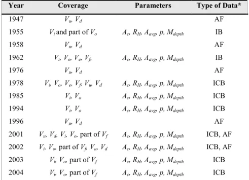
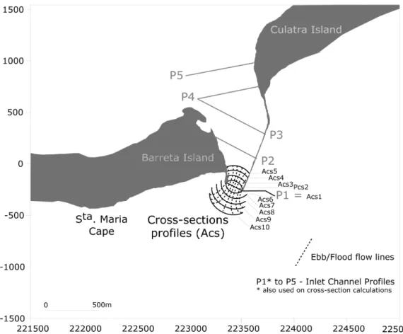
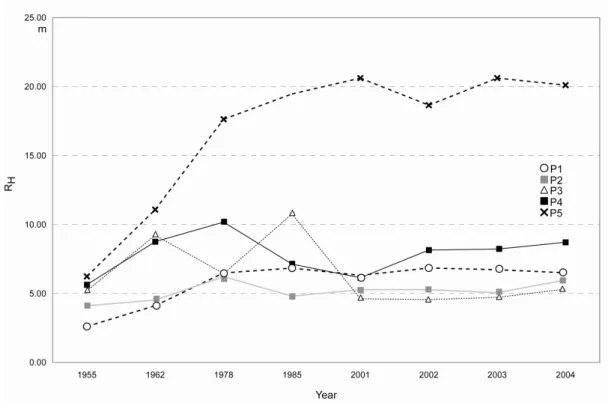
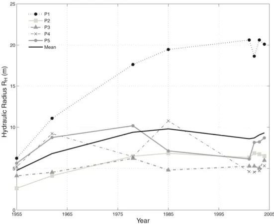
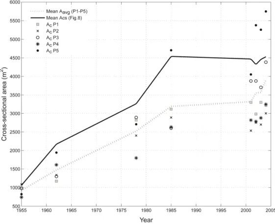
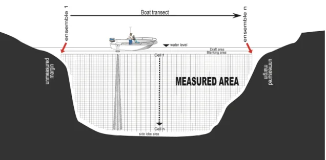
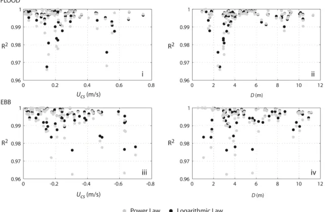
(16) List of Figures Figure II.1 Ebb- and flood-tidal delta boundaries used to perform volume calculations. Annotations include the landward limit (Ll), the seaward limit (Sl), the no-delta profile (3d), the ebb-delta profile (Ed), and the average thickness of both deltas (Ze and Zf) .................................................................................. 23 Figure II.2 Ria Formosa Barrier Island System, including the location of the Faro-Olhão Inlet and adjacent shoreline ...................................................................................................................................... 30 Figure II.3 Schematic representation of the compartments (cells) defined for volumetric computation. Coordinates refer to the Portuguese Military Grid ......................................................................................... 33 ................................................................................................................................................................... 35 Figure II.4 Digital topo-bathymetric maps for 1962, 1978, and 2001. Co-ordinates refer to the Portuguese Military Grid. Elevation is referred to msl................................................................................................. 35 Figure II.5 Ebb-tidal delta profiles, both North-South (PNS1-7) and East-West (PEW1-6), and flood-tidal delta profiles (PFl1-14), plotted over the digital contour map of 1978. Pe0 and Pf0 represent the no-delta profiles. Co-ordinates refer to the Portuguese Military Grid. Elevation is referred to msl ........................ 36 Figure II.6 Location of the shoreline normal profiles used to determine the shoreline evolution of the barrier islands............................................................................................................................................. 40 Figure II.7 Evolution of Barreta and Culatra islands between 1929 and 2001 .......................................... 42 Figure II.8 Configuration of five cross-section profiles along the inlet channel (P1-P5) and 10 equi-spaced cross-section profiles normal to the ebb and flood flow lines (Acs1 – Acs10). Co-ordinates refer to the Portuguese Military Grid ........................................................................................................................... 45 Figure II.9. RH evolution for profiles P1 to P5 between 1955 and 2004.................................................... 46 Figure II.10 Average cross-sectional area (Aavg) of inlet channel area (P1-P5) and minimum crosssectional area (Ac) of Faro-Olhão Inlet measured using the CEM method, 1955-2004............................. 47 Figure II.11 Faro-Olhão Inlet budget and rms uncertainty of the ΣQsource - ΣQsink balance for two study periods: 1962-1978 (A) and 1978-2001 (B) .............................................................................................. 49 Figure III.1 Schematisation of the ADCP measurement along a transect course, with explanation of the recorded ensembles, draft, blanking, sidelobe areas, and unmeasured and measured areas ...................... 70 Figure III.2 The Ria Formosa multi-inlet lagoon system (Southern Portugal) .......................................... 72 Figure III.3 Instantaneous velocity distribution of the flow structure through a cross-section at slack water (A), flood peak (B) and ebb peak (C) and adjustment of the 1/6 power and logarithmic law for three consecutive ensembles at each of the cross-sections ................................................................................. 79 Figure III.4 Coefficient of determination (R2) between computed cross-sectional velocities ( U cs ) using the raw data and both theoretical models for the six inlets, under both neap and spring tide conditions .. 80 Figure III.5 Distribution of coefficient of determination values (R2) comparing theoretical models and raw cross-section velocity ( U cs ), versus U cs magnitude and depth (D), for flood/ebb flow, for the six inlets ................................................................................................................................................................... 81 Figure IV.1 The Ria Formosa multiple-inlet system. Tide gauges and ADV location (adapted from Salles, 2001) and ADCP survey transect locations are shown .............................................................................. 94 Figure IV.2 (A) Faro-Olhão inlet cross-section evolution (adapted from Pacheco et al., 2008); (B) FaroOlhão Inlet Escoffier Curve; and (C) Armona Inlet width evolution (adapted from Andrade, 1990) ....... 96 Figure IV.3. Hydrodynamic data sampling scheme................................................................................... 99 Figure IV.4. Ria Formosa inlets at spring-tides: (A) tidal prism; (B) mean cross-section velocities; (C) residual discharge; and (D) mean residual velocity. In all cases, positive values refer to flood and negative to ebb ....................................................................................................................................................... 107 Figure IV.5 Ria Formosa inlets at neap-tides: (A) tidal prism; (B) mean cross-section velocities; (C) residual discharge; and (D) mean residual velocity. In all cases, positive values refer to flood and negative to ebb ....................................................................................................................................................... 109 Figure V.1 Ria Formosa Multi-Inlet System, Southern Portugal, showing the Ancão tidal inlet, equipment deployment location and sampling positions ........................................................................................... 126 Figure V.2 Offshore/inshore pressure transducer levels (A); τ0 (water slope method) and τ (mean of RS and TKE methods) (B); 1 s burst average values of UDA (C); Uw (D); τTKE and τRS (E); and τ components (F) ............................................................................................................................................................ 136 Figure V.3 Bedform morphology at the inner inlet channel, backbarrier side and at the updrift swash platform, Ancão Peninsula (A); height (A) and length (B) of bedforms determined empirically............ 137 Hydrodynamic and Sediment through the Inlets of Ria Formosa. xv.
(17) Figure V.4 Flood/ebb derived relations between ka and ks from Eq. 8 (A); 1 s burst average values ka and ks values (B); Cd (C); and Cf mean values determined by the XBeach (D)............................................. 138 Figure V.5 Mass suspended sediment rate through the tidal cycle at Ancão tidal inlet (A) and volumetric transport rate as a function of the depth-average velocity for current-only processes with eddy diffusion varying linearly; parabolically (B) with the flow; and for the current-wave interaction (C) ................... 140 Figure V.6 Interpolated values of UDA (A), qb (B) and qs (C) derived from the ADCP and sediment properties data for the spring-tide tidal cycle survey performed at Ancão tidal inlet .............................. 141 Figure V.7 Annual sediment transport estimates for the Ria Formosa inlets........................................... 143 Figure VI.1 (A) Study area comprising the Ria Formosa multiple inlet system, southern Portugal (Google Earth, aerial photo from 2006). (B) Detail of the location of the artificially-opened Faro-Olhão Inlet (prior to opening, superimposed on a 1923 map, adapted from Esaguy, 1986)................................................. 161 Figure VI.2 Faro-Olhão Inlet channel evolution from 1948-2006. Co-ordinate system: Datum 73, Portuguese Military Grid. ........................................................................................................................ 164 ................................................................................................................................................................. 165 Figure VI.3. Armona Inlet evolution 1873-2006 (adapted from Esaguy, 1984). ..................................... 165 Figure VI.4. (A) Location of channel profiles measured and analyzed (B) channel evolution and (C) minimum cross-sectional evolution of Faro-Olhão Inlet from 1948-2006. Co-ordinate system: Datum 73, Portuguese Military Grid. ........................................................................................................................ 172 Figure VI.5. Escoffier’s Curve (sensu Escoffier, 1977) for Faro-Olhão Inlet, where Um is given by the linear approach (from Dean and Dalrymple, 2002) and Ue is from Jarret (1976).................................... 172 Figure VI.6. (A) Digital Terrain Models of Culatra Island (Lidar Survey, November 2009). (B) Culatra Island evolution from 1947-2009............................................................................................................. 174 Figure VI.7. Evolution of Faro-Olhão Inlet cross-section Ac, Culatra Island area A, and Armona Inlet width W.................................................................................................................................................... 175 Figure VI.8. Ratio between Faro-Olhão Inlet Ac / Armona Inlet W and between Culatra Island A / Armona Inlet W....................................................................................................................... 176. Hydrodynamic and Sediment through the Inlets of Ria Formosa. xvi.
(18) List of Tables Table II.1 Cell coverage, measured parameters, and types of data used in the sediment budget computation for Faro-Olhão Inlet .............................................................................................................. 33 Table II.2 Best estimate (BE) values and uncertainties of the individual cells used to compute the sediment budget for the Faro-Olhão Inlet .................................................................................................. 35 Table III.1 General inlet characteristics and mean survey parameters: cross-section (Ac), channel depth (D), channel length (L), transect travel time (Tt) and collected ensembles per transect (Ens) .................. 73 Table IV.1 General characteristics of Ria Formosa inlets ......................................................................... 96 Table IV.2 Tide gauges and ADV deployment duration, data return, and average flood and ebb durations at each station for a complete lunar cycle (adapted from Salles, 2001)..................................................... 98 Table IV.3 Tide conditions for the survey days....................................................................................... 100 Table IV.4 Ria Formosa multiple-inlet system hydrodynamics (spring- and neap-tide conditions). Positive values refer to flood conditions and negative to ebb. Ac is cross-shore channel area; P is tidal prism; U is velocity; and T is duration ....................................................................................................................... 105 Table V.1 Summary of sediment parameters from analysis of samples and thresholds of motion derived from empirical formulae .......................................................................................................................... 134 Table V.2 Estimates of mass (kgm-1s-1) and volumetric (m3year-1) transport rates using different models for bedload and suspended transport for a ADCP tidal cycle performed at Ancão tidal inlet during springtides.......................................................................................................................................................... 142 Table VI.1. Data and methods used to evaluate Culatra Island (area and length) evolution and Armona Inlet (width) evolution ............................................................................................................................. 170 Table VI.2. Parameters used in the linear method (Dean and Dalrymple, 2002) approach to Keulegan (1967) for establishing an Escoffier (1977) curve for Faro-Olhão Inlet. ................................................. 173 Table VI.3. Compilation of Faro-Olhão and Armona inlets’ spring tidal prisms through time, and the methods used for the calculations. ........................................................................................................... 176. Hydrodynamic and Sediment through the Inlets of Ria Formosa. xvii.
(19) CHAPTER I. Introduction.
(20) Chapter I. Introduction. I.1 MULTI-I LET SYSTEMS Tidal inlets are located within barrier island systems and are found throughout the world in a variety of geologic and oceanographic settings, primarily on coastal plain shorelines (FitzGerald, 1988). An inlet is defined as a tidal inlet when the flow of water is dominated by the tide as opposed to river discharge (Escoffier, 1940). Despite being complex coastal systems and difficult to model, tidal inlets are of great importance as navigation routes, sediment sources for adjacent beaches, and conduits that allow exchange of nutrients between backbarrier systems and the coastal zone (FitzGerald 1996). Tidal inlets strongly influence the overall dynamics of barrier island shorelines because they interrupt the wave-induced transport of sediment along the coast, affecting both the supply of sand to downdrift shorelines and erosional-depositional patterns on adjacent beaches. The degree to which barrier islands are affected by inlet processes is dependent on the number of tidal inlets and their size (FitzGerald, 1988). The origin, morphology, hydrodynamics and stability of tidal inlets are highly variable due to a wide range in physical settings such as wave and tidal energy, sediment supply, origin of the backbarrier, bedrock geology, sea-level history, storm occurrence and anthropogenic factors (FitzGerald, 1996). Hayes (1979) was the first to recognize the important influence that tidal range has on tidal inlets and barrier morphology and, through the tidal range classification proposed by Davies (1964), he identified five general categories of shoreline and established their relationship with the presence or absence of barrier island systems and tidal inlets. According to Hayes’ (1979) classification, multiple tidal inlets can occur on microtidal coasts (mean tidal range < 1m), characterised by long, narrow, straight barriers with widely spaced inlets; whilst low mesotidal coasts (mean tidal range 1-2 m) are generally characterised by an increased number of small tidal inlets, normally wave dominated (FitzGerald, 1996),. Hydrodynamic and Sediment through the Inlets of Ria Formosa. 2.
(21) Chapter I. Introduction. and high mesotidal coasts (mean tidal range 2-3.5 m) may have abundant tidal inlets and the coast, although mixed-energy, is normally dominated by tidal processes. Along lowmacrotidal (mean tidal range 3.5-5 m) and macrotidal coasts (mean tidal range > 5 m), barriers do not develop. According to FitzGerald (1988), there is a strong correlation between barrier islands and tidal range/wave energy, which also controls the size and number of tidal inlets. The existence and persistence of multiple tidal inlets in coastal systems is fundamental for understanding issues such as flushing capability, navigability, and beach/barrier stability, as these depend on factors not found in single-inlet systems. According to Salles et al. (2005), multiple inlet systems should not be approached in terms of the stability of each inlet, but focus on their persistence through time. Multiple tidal inlet systems, such as the Ria Formosa, are hydrodynamically connected, and therefore a morphological change in a given inlet will/should/could modify the hydrodynamic behaviour of other inlets and adjacent channels. These include changes to the tidal prism, generation of residual discharge and alteration of the non-linear tidal distortion signal (Salles et al., 2005). These changes are, in general, a function of channel hydraulics, i.e. tidal prism, which is a measure of the water exchange through the inlet. Thus, when a new inlet is opened and stabilised, its tidal prism will increase until it reaches equilibrium between its cross-section and the volume of water flowing through the inlet. Morphological changes can occur in areas adjacent to the new inlet over years to centuries, and coastal response to engineering stabilisation may extend far updrift and downdrift of the inlet. In a multiple tidal inlet system the changes can be more dramatic because the current field will change completely, inducing short- and long-term impacts on water circulation through the other inlets.. Hydrodynamic and Sediment through the Inlets of Ria Formosa. 3.
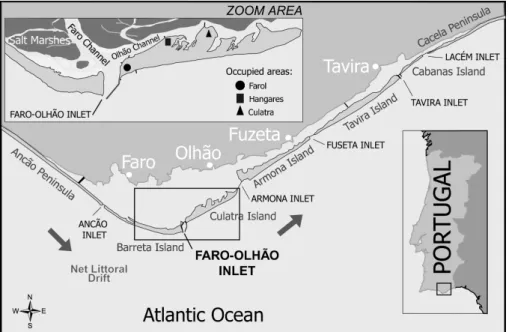
(22) Chapter I. Introduction. Lack of water oxygenation and nutrient fluxes, navigability constraints and coastal hazards are likely to occur as a result of human intervention.. I.2. THE RIA FORMOSA I THE CO TEXT OF I TER ATIO AL RESEARCH O TIDAL I LETS The Ria Formosa is a highly dynamic multi-inlet barrier island system located in the Algarve region of Southern Portugal. Several economic activities take place in the system, e.g. aquaculture, salt production, fishing, shellfish culture, shipping, mining and tourism. Presently, the Ria Formosa’s shellfish production represents 60 % of the Portuguese total . The combination of different and often competing economic activities makes management of the Ria Formosa a very difficult task for decision makers in the region. The origin of the Ria Formosa is not clear, and several geological hypotheses for the system’s genesis have been proposed (Dias, 1988; Pilkey et al., 1989; Bettencourt, 1994). Dias (1988) and Pilkey et al. (1989) followed the Hoyt (1967, cited in Pilkey et al., 1989) model, suggesting that the origin of the sand islands is related to changes in sea-level during and after the glacial period, i.e., the Ria’s Holocene evolution fits within the classical shoreface transgression model. The Ria Formosa system has been the subject of several PhD theses and scientific research papers, especially during the second half of the 20th century (Weinholtz, 1964; Dias, 1988; Pilkey et al., 1989; Andrade, 1990). Scientific interest in the Ria Formosa inlets is particularly related to the artificial relocation of the Ancão inlet in 1997 and the Fuzeta inlet in 1999. Inlet relocation is a novel coastal management tool that, when applied to a migrating inlet, consists of opening an inlet within the historic migration path of another inlet. These engineering interventions - the 3rd and 4th such relocations. Hydrodynamic and Sediment through the Inlets of Ria Formosa. 4.
(23) Chapter I. Introduction. in the world - and the subsequent publication of their implementation (i.e. Balouin, 2001; Morris et al. 2001, 2004; Salles, 2001; Salles et al., 2005; Vila-Concejo et al. 2002, 2003, 2004, 2006; Vila-Concejo, 2003; Williams et al. 2003a,b) made Portugal an international reference in tidal inlet studies. These publications are outcomes of the “Inlet Dynamics Initiative” (INDIA Project), supported by the European Commission (Contract MAS3-CT97-0106). INDIA’s aim was to gain a better understanding of the interactions between tides, waves, currents and sedimentary processes at work in the European coastal zone to better predict change. In the Algarve, fieldwork activities centred on the Ancão Inlet, using state-of-the-art field equipment to study present-day processes (Williams et al., 2003a,b) and a range of numerical models to extend the spatial and temporal range of the measurements. A doctoral thesis by Salles (2001) and a subsequent paper (Salles et al., 2005) are the two main studies on multiple inlet hydrodynamics and stability that focus on the Ria Formosa inlets. By combining a numerical simulation of inlet flow with a semiempirical approach of inlet equilibrium, numerical simulations of the hydrodynamics of the Ria Formosa multi-inlet system were performed. These numerical simulations were mainly based on creating realistic physical disturbance (changes to inlet cross-sections) and analysing the hydrodynamic response of the multi-inlet system to those disturbances. The authors showed the importance of nonlinear processes in the hydrodynamics of multi-inlet systems, such as tidal distortion, ebb/flood dominance and residual flow patterns, and reinforced the need to consider these factors when analysing inlet stability in such systems. Whilst these works greatly contributed to understanding the importance of nonlinear processes in the hydrodynamics of multi-inlet systems, the modelling results were not validated by field measurements, or in terms of current or sediment transport. The tidal prism and sediment transport through the inlets (i.e. trends. Hydrodynamic and Sediment through the Inlets of Ria Formosa. 5.
(24) Chapter I. Introduction. and magnitudes), which would allow the estimation of the present and historic sediment budget, was not presented in the works of Salles. Moreover, Salles’ scenarios for crosssectional changes do not accurately reflect the historical evolution of the system; neither achieving a state of “dynamic equilibrium”.. I.3 THESIS AIM As demonstrated in the previous section, knowledge about the Ria Formosa inlets has improved through the last few years. There have been studies on the migration and current behaviour of some of the inlets of the Ria Formosa; however, data on the tidal prism and sediment fluxes is scarce. Scientific knowledge of these processes is considered to hold the key to correct management of inlets and surrounding areas. As well as quantifying the sediment transport through the inlets, determining ebb or flood dominance for each inlet is another objective of the present thesis. This will enable sediment budgets to be determined and help predict the future evolution of these systems. The results are expected to show how dynamic equilibrium can be achieved, with potential applications for the formulation of integrated coastal management policies. Sediment budgets for coastal areas are an essential tool for determining the amount of sediment that can be removed from the system with minimal environmental impact. Additionally, the quantification of relationships between tidal prism and sediment fluxes in a multi-inlet system has never been previously attempted at this scale, and may therefore find application in other, similar systems worldwide. The thesis includes an in-depth study of the Ria Formosa inlets, determining tidal prism distribution and circulation patterns, sediment fluxes and recent historical evolution in relation to anthrophic influence. The main chapters of this thesis correspond to scientific papers that were all submitted to international scientific. Hydrodynamic and Sediment through the Inlets of Ria Formosa. 6.
(25) Chapter I. Introduction. journals. The advantage of presenting a thesis by articles is that each chapter can be read independently; however, this format has the disadvantage of repeating certain details (e.g. study area description). While it is acknowledged that this repetition may hinder the flow of the text, the format has been maintained to preserve the integrity of the original scientific papers.. I.4 THESIS OUTLI E Considering the importance of recent anthropogenic modifications in the Ria Formosa and the study of their impacts in the context of international research on inlet dynamics, the main objective of this thesis is to analyse evolutionary trends in the hydrodynamic and sediment fluxes of the system. The thesis comprises seven chapters:. •. A brief introduction is given in Chapter I, referring to the socio-economic importance of the Ria Formosa System and providing a scientific justification for the work undertaken;. •. Chapter II describes the various methods used to calculate sediment budgets on the basis of historical documents and gives an example of their implementation to the Faro-Olhão inlet, the main inlet of the Ria Formosa system. The work was published in Marine Geology on the 17th July 2007: Pacheco, A., Vila-Concejo, A., Ferreira, Ó., Dias, J.A., 2008. Assessment of Tidal Inlet Evolution and Stability Using Sediment Budget Computations and Hydraulic Parameter Analysis. Marine Geology 247, 104-127.. •. Chapter III evaluates methods for extrapolating velocity measurements to the unmeasured areas of Acoustic Doppler Current Meter (ADCP) profiles, selecting the best method for accurate tidal prism values, as well as increasing the reliability. Hydrodynamic and Sediment through the Inlets of Ria Formosa. 7.
(26) Chapter I. Introduction. of the sediment transport estimations. The work was submitted to Continental Shelf Research and is currently under review: Pacheco, A., Faísca, L., Almeida, L., Ferreira, Ó., Williams, J.J., Dias, J.A. (under review). A statistical evaluation of models for extrapolating current velocities from boat-mounted ADCP profiles. Continental Shelf Research.. •. Chapter IV focuses on tidal prism distribution through the multiple-inlet system, based on detailed current measurements taken at all of the inlets of the Ria Formosa, through which residual flows and flood/ebb dominance could be determined. It was published in Marine Geology on the 15th March 2010: Pacheco, A., Ferreira, Ó., Williams, J.J., Garel, E., Dias, J.A., 2010. Hydrodynamics and equilibrium of a multiple-inlet system. Marine Geology 274, 32-42.. •. Chapter V uses a combination of several transport models to estimate trends in net bedload, suspended and total transport, providing the basis for an annual sediment budget and a conceptual model. This work was recently submitted to Estuarine and Coastal Shelf Science, Elsevier, and builds on an earlier paper that was published in Journal of Coastal Research: Pacheco, A., Williams, J.J., Ferreira, Ó., Garel, E., Reynolds, S. (submitted). Application of Sediment Transport Models to a Multiple-Inlet System. Estuarine and Coastal Shelf Science. Pacheco, A., Williams, J.J., Ferreira, Ó., Dias, J.A., 2009. Evaluation of shear stress computation at a tidal inlet using different methods. Journal of Coastal Research 56, , 1385-1389.. •. Chapter VI examines multiple tidal-inlet stability based on historical morphological changes–to infer the equilibrium state and future evolution of the system, with particular emphasis on the impact of engineering modifications. This work was recently submitted to Earth Surface Processes and Landforms: Pacheco, A., Ferreira, Ó., Williams, J.J. (submitted). Long-term Morphological Impacts of the Opening of a New Inlet on a Multiple Inlet System. Earth Surface Processes and Landforms.. Hydrodynamic and Sediment through the Inlets of Ria Formosa. 8.
(27) Chapter I. Introduction. •. Chapter VII, the final chapter, presents the general conclusions of the study and proposes future directions for multiple tidal-inlet research, both nationally and internationally.. I.5 REFERE CES Andrade, C. F., 1990. O Ambiente Barreira da Ria Formosa, Algarve-Portugal. PhD Thesis, Universidade de Lisboa. 627 p. (in Portuguese). Balouin, Y., H. Howa, and D. Michel. 2001. Construction of the swash platform associated to an ebb-tidal delta during fair weather conditions, The Barra Nova inlet, South Portugal. J. Coast. Res. 17, 4784–791. Davies, J.L., 1964. A morphologic approach to world shorelines. Zeits Geomorphol., 8, 127-142. Dias, J.M.A. 1988. Aspectos geológicos do litoral algarvio. Geonovas (Lisboa), 10, 113128 (in Portuguese). FitzGerald, D.M., 1988. Shoreline erosional-depositional processes associated with tidal inlets. In: Hydrodynamics and Sediment Dynamics of Tidal Inlets. Lecture Notes on Coastal and Estuarine Studies 29, 186-225. FitzGerald, D.M., 1996. Geomorphic Variability and Morphologic and Sedimentologic Controls on Tidal Inlets. J. Coast. Res. SI 23, 47-71. Hayes, M.O., 1979. Barrier island morphology as a function of tidal and wave regime. In Leatherman, S.P., (Ed.), Barrier Islands: From the Gulf of St. Lawrence to the Gulf of Mexico. Academic Press, New York, N.Y., 1-27. Jarret, J.T., 1976. Tidal Prism-Inlet area relationships. GITI Report, vol. 3. U.S. Army Corps of Engineers, Waterways Experiment Station, Vicksburg, MS.. Hydrodynamic and Sediment through the Inlets of Ria Formosa. 9.
(28) Chapter I. Introduction. Morris, B.D., Davidson, M.A., Huntley, D.A., 2001. Measurements of the response of a coastal inlet using video monitoring techniques. Mar. Geol. 175, 251-272. Morris, B.D., Davidson, M.A., Huntley, D.A., 2004. Estimates of the seasonal morphological evolution of the Barra Nova Inlet using video techniques. Cont. Shelf. Res. 24, 263-278. O’Brien, M.P., 1969. Equilibrium Flow Areas on Inlets on Sandy Coasts. J. Waterw. Harb. Div. 95 (WW1), 43-52. Pilkey, O.H., Neal, W.J., Monteiro J.H., Dias, J.M.A., 1989. Algarve Barrier Islands: a noncoastal-plain system in Portugal. J. Coast. Res. 5(2), 239-261. Salles, P., 2001. Hydrodynamic Controls on Multiple Tidal Inlet Persistence. PhD Thesis, Massachusetts Institute of Technology and Woods Hole Oceanographic Institution, 272 pp. Salles, P., Voulgaris, G., Aubrey, D., 2005. Contribution of nonlinear mechanisms in the persistence of multiple tidal inlet systems. Estuar. Coast. Shelf. Sci. 65, 475-491. Vila-Concejo, A., 2003. “Sediment Dynamics and Tidal Inlet Relocation in MixedEnergy Settings: The case of Ancão Inlet (Algarve – Portugal). PhD Thesis, Universidade do Algarve. 197p. Vila-Concejo, A., Matias, A., Ferreira, Ó., Duarte, C., Dias, J.M.A., 2002. Recent Evolution of the Natural Inlets of a Barrier Island System in Southern Portugal. J. Coast. Res. SI 36, 741-752. Vila-Concejo, A., Ferreira, Ó., Matias, A., Dias, J.M.A., 2003. The first two years of an inlet: sedimentary dynamics. Cont. Shelf. Res. 23, 1425-1445. Vila-Concejo, A., Ferreira, Ó., Matias, A., Morris, B.D., Dias, J.A., 2004. Lessons from inlet relocation: examples from Southern Portugal”. Coast. Eng. 51 (10), 967-990.. Hydrodynamic and Sediment through the Inlets of Ria Formosa. 10.
(29) Chapter I. Introduction. Vila-Concejo, A., Matias, A., Pacheco, A., Ferreira, Ó., Dias, J.M.A., 2006. Inlet hazard determination in the Ria Formosa barrier island system. Cont. Shelf. Res. 26 (9), 1045-1060. Williams, J.J., Bell, P.S., Thorne, P.D., 2003a. Field measurements of flow fields and sediment transport above mobile beds. J. Geophy. Res. 108, NO. C4, 3109, doi:10.1029/2002JC001336. Weinholtz, M.B., 1964. Contribuição para o Estudo da Evolução das Flechas de Areia na Costa Sotavento do Algarve. Separata do Boletim Trimestral de Informação do D.G.S.H. 14. (in Portuguese). Williams, J.J., O’Connor, B.A.O., Arens, S.M., Abadie, S., Bell, P., Balouin, Y., Van Boxel, J.H., do Carmo, A.J., Davidson, M., Ferreira, Ó., Heron, M., Howa, H., Hughes, Z., Kaczmarec, L.M., Kim, H., Morris, B., Nicholson, J., Pan, S., Salles, P., Silva, A., Smith, J., Soares, C., Vila-Concejo, A., 2003b. Tidal inlet function: field evidence and numerical simulation in the INDIA project. J. Coast. Res. 19(1), 189211.. Hydrodynamic and Sediment through the Inlets of Ria Formosa. 11.
(30) CHAPTER II. Assessment of tidal inlet evolution and stability using sediment budget computations and hydraulic parameter analysis.
(31) Chapter II. Assessment of tidal inlet evolution and stability using sediment budget computations and hydraulic parameter analysis. Abstract Research into the response of coastlines to the opening and stabilisation of inlets has been limited by the availability of suitable data, the shortcomings of existing formulae when applied to different inlets, and the difficulties particular to multi-inlet situations. Our appraisal of methodologies for studying inlet dynamics leads us to formulate a new approach for investigating inlet evolution and stability based on combining sediment budget computations (using best estimates and uncertainty analysis) and inlet hydraulic parameter analysis. The approach developed is applied to a stabilised inlet, located within a multi-inlet system (Faro-Olhão Inlet, Ria Formosa, Southern Portugal), which was opened starting 1929 and has since been dredged periodically to maintain navigability. A series of digital maps was produced based on multi-year data acquired from charts, surveys, and aerial photos. The maps were used to compute sediment volumes for six coastal cells delineated on the basis of the morphological features of the inlet. Cell volumes and fluxes were calculated for three periods (1929-1962, 1962-1978, and 1978-2001), and overall sediment budgets were calculated for the latter two periods. Inlet hydraulic parameters measured included tidal prism, inlet channel cross-sectional area and hydraulic radius, and maximum depth of the inlet throat, and were tracked over 13 bathymetric surveys from 1947-2004. The computed budget reveals that the inlet is only at present reaching volumetric equilibrium. However, the analysis of channel cross-sectional area and radius indicates parameter stability around 1978-1985, 20-25 years before the inlet started to reach volumetric equilibrium. It is hypothesised that the observed stability in parameters for the. Hydrodynamic and Sediment Fluxes through the Inlets of Ria Formosa. 13.
(32) Chapter II. Assessment of tidal inlet evolution and stability using sediment budget computations and hydraulic parameter analysis. inlet post-1978 is related to the presence of fixed jetties and to a stratigraphic control that prevents further deepening, and not to the achievement of a dynamic equilibrium. The findings indicate that the coupling of sediment budget computation and inlet parameter analysis is useful for understanding historical sediment pathways and magnitudes, and for analysing the evolution of an inlet towards equilibrium. Although the analysis of inlet parameter evolution is valuable for examining the locational/geometrical stability of an inlet, it needs to be used in conjunction with sediment budget computations in order to properly infer inlet equilibrium. Moreover, existing formulae used to infer inlet stability, which relate cross-sectional area to tidal prism, should be reviewed with a view to including other external variables (e.g., stratigraphic controls) and to making their application more flexible to cope with the range of different inlet conditions. For multi-inlet systems, the coupling of morphology and hydrodynamics analysis should be extended to all inlets in order to infer the stability of the overall system based on the distribution of the tidal prism through time and the patterns of inlet circulation and sediment transport.. Keywords: tidal inlet; equilibrium; tidal prism; cross-section area; volume computation; sediment budget. Hydrodynamic and Sediment through the Inlets of Ria Formosa. 14.
(33) Chapter II. Assessment of tidal inlet evolution and stability using sediment budget computations and hydraulic parameter analysis. II.1. I TRODUCTIO. Tidal inlets rate among the most dynamic of coastal features. The complex temporal and spatial interactions of waves, tides, and currents create and constantly modify the morphology and the sedimentary structure of tidal inlets. Quantification of the magnitudes, rates, and patterns of geomorphic change is central to sediment budget calculations, to the estimation of dredging requirements, and to the assessment of the extent to which inlet dynamics affect adjacent beaches (Stauble, 1998). Better understanding of the dynamics and evolution of inlets can be achieved by comprehensive investigations of sediment budgets, which are essential for understanding complex inlets whether in natural or engineered condition (Rosati and Kraus, 1999). However, the main constraint on performing sediment budget computations is the paucity of good quality datasets (comprising frequent observations over long periods) and site information, as well as the need to estimate best values and their associated uncertainties which derive from a number of error sources. Research into the consequences of engineering works on the long-term behaviour of inlet systems has been hindered by the absence of such datasets. This paper investigates the importance of using sediment budget computation jointly with inlet parameter analysis in order to understand coastline changes resulting from the opening and stabilisation of tidal inlets. Existing methods used to examine inlet evolution are evaluated, and a new methodology is developed which is demonstrated with application to the artificially stabilised Faro-Olhão Inlet in Southern Portugal. The study applies new concepts developed by Rosati (2005) in order to compute a sediment budget, with an emphasis on uncertainty calculations. However, instead of using LST rates and computing several Hydrodynamic and Sediment Fluxes through the Inlets of Ria Formosa. 15.
(34) Chapter II. Assessment of tidal inlet evolution and stability using sediment budget computations and hydraulic parameter analysis. “representative budgets,” our approach is to consider the rate of longshore transport as incognito and immutable, coupling the obtained balanced budget with inlet parameter analysis in order to understand sediment pathways and accretion/erosion tendencies within each coastal cell.. II.1.1 Sediment Budgets A sediment budget is a computation of sediment gains and losses, or sources and sinks, within a specific control volume (or cell) over a given time, and can be expressed by. ∑ Q source − ∑ Qsin k − ∆V + PL − R = Re sidual. (II.1). where: Qsource and Qsin k are the sources and sinks to the control volume, respectively; ∆V is the net change in volume within the cell; PL and R are the amounts of material placed into and removed from the cell, respectively; and Residual represents the degree to which the cell is balanced (Rosati, 2005). The accounting for uncertainties in the various components that comprise the sediment budget yields an indicator of the reliability of the budget, as well as bounds for judging the range of values that might be taken by the more uncertain quantities (Kraus and Rosati, 1999). Several studies of sediment budget computations have applied Eq. II.1 to estimate values of the best-known variables and solve the lesser-known terms. A detailed review of the various methods used for estimating best values in order to perform sediment budget computations is provided by Rosati (2005). Rosati has also constructed a personal computer-based program, the Sediment Budget. Hydrodynamic and Sediment through the Inlets of Ria Formosa. 16.
(35) Chapter II. Assessment of tidal inlet evolution and stability using sediment budget computations and hydraulic parameter analysis. Analysis System (SBAS) (Kraus and Rosati, 1998; Rosati and Kraus, 1999), which enables sediment budget computations to be constructed and formulated within a georeferenced framework. The program relies on the importance given to the calculation of uncertainty, considered to be a central element of modern data treatment (Rosati, 2005). Uncertainty enters through limited knowledge of changes in ebb- and flood-tidal delta sand volumes, and of the paths and relative magnitudes of longshore sediment transport (LST). When a new inlet is formed, sand is withdrawn from the longshore transport system until the ebb-tidal delta attains an equilibrium volume. Over long time scales, the total amount of sand stored in an ebb-tidal delta is reasonably constant if the inlet is in equilibrium. However, measuring variation in the quantity of sediment stored in an ebbtidal delta over time requires historical datasets that are often either non-existent, unavailable, or unreliable. Sediment budgets often fail to present accurate values due to the difficulties in delimiting coastal cells and computing their volumes, assigning historical dredging and beach nourishment volumes and, most importantly, assigning values to Qsource and Qsin k , essential for determining rates of LST. Typically, the total (or gross) LST rate is computed using the Coastal Engineering Research Center (CERC) formula (SPM, 1984). However, the assumptions made in the development of the CERC formula, and its treatment of uncertainty, raise questions concerning its value for performing sediment budget computations.. Hydrodynamic and Sediment through the Inlets of Ria Formosa. 17.
(36) Chapter II. Assessment of tidal inlet evolution and stability using sediment budget computations and hydraulic parameter analysis. II.1.2 Inlet Hydraulics and Stability Tidal inlets display two types of stability: locational and geometrical (Mason, 1986). For inlets stabilised with two jetties, there is no migration and thus they possess locational stability. However, a stabilised inlet may have geometrical instability if its cross-sectional area (Ac), size, and shape change (O’Brien, 1969; Jarret, 1976). These geometrical changes are in general a function of variations in channel hydraulic parameters such as tidal prism (P), the volume of water exchanged between an estuary and the open sea during a tidal period. Several studies have presented empirical formulas relating Ac to P, including O’Brien’s (1969) equation which relates the minimum equilibrium cross-section area with the volume of water flowing into or out of an inlet in response to tidal prism fluctuations. A more precise method of prism determination is the cubature method (Jarret, 1976), which takes into account the time required for a tide to propagate through a bay, rather than assuming a uniform rise and fall of the bay tide. In the first analytical approach to inlet stability analysis, Escoffier (1940) proposed a diagram based on the plotting of two curves: the first being the maximum cross-sectionally averaged velocity (Um) curve, produced by varying Ac; and the second the equilibrium velocity curve (UE) (a stability criterion curve such as O’Brien’s (1969) and Jarret’s (1976) tidal-prism versus cross-section area relationship). These formulations are widely used for inlet stability evaluation and for engineering design projects. Bruun (1978) considered tidal inlet stability as a function of tidal prism and sediment inflow capacity, including (for the first time) littoral drift in inlet stability analysis. Gao and Collins (1994a; 1994b) followed this with several analytical approaches that included the effect of independent variables (e.g. flood- and ebb-tidal durations, tidal prism, longshore Hydrodynamic and Sediment through the Inlets of Ria Formosa. 18.
Imagem

+7
Documentos relacionados