www.solid-earth.net/2/107/2011/ doi:10.5194/se-2-107-2011
© Author(s) 2011. CC Attribution 3.0 License.
Solid Earth
Re-evaluation of the Mentelle Basin, a polyphase rifted margin
basin, offshore southwest Australia: new insights from
integrated regional seismic datasets
D. Maloney1, C. Sargent1, N. G. Direen2,3, R. W. Hobbs1, and D. R. Gr¨ocke1
1Department of Earth Sciences, Durham University, South Road, Durham DH1 3LE, UK 2School of Earth Sciences, University of Tasmania, Sandy Bay, Tasmania, 7000, Australia 3FrOG Tech Pty Ltd, Blackmans Bay, Tasmania, 7052, Australia
Received: 16 December 2010 – Published in Solid Earth Discuss.: 3 February 2011 Revised: 31 May 2011 – Accepted: 2 June 2011 – Published: 7 July 2011
Abstract.Vintage 2-D (two-dimensional) seismic reflection surveys from the sparsely explored Mentelle Basin (west-ern Australian margin) have been reprocessed and integrated with a recent high-quality 2-D seismic survey and strati-graphic borehole data. Interpretation of these data sets al-lows the internal geometry of the Mentelle Basin fill and depositional history to be reanalysed and new insights into its formation revealed. Basin stratigraphy can be subdivided into several seismically defined megasequences separated by major unconformities related to both breakup between India-Madagascar and Australia-Antarctica in the Valanginian-Late Hauterivian and tectonically-driven switches in depo-sition through the Albian.
Resting on the Valanginian-Late Hauterivian breakup un-conformity are several kilometre-scale mounded structures that formed during Late Jurassic to Early Cretaceous exten-sion. These have previously been interpreted as volcanic ed-ifices although direct evidence of volcanic feeder systems is lacking. An alternative interpretation is that these features may be carbonate build-ups. The latter interpretation carries significant climatic ramifications since carbonate build-ups would have formed at high palaeolatitude,∼60◦S.
Soon after breakup, initial subsidence resulted in a shal-low marine environment and deposition of Barremian-Aptian silty-sandy mudstones. As subsidence continued, thick suc-cessions of Albian ferruginous black clays were deposited. Internally, seismic megasequences composed of successions of black clays show previously unresolved unconformities, onlapping and downlapping packages, which reflect a
com-Correspondence to:D. R. Gr¨ocke ([email protected])
plex depositional, rifting and subsidence history at odds with their previous interpretation as open marine sediments.
Southwestwards migration of the Kerguelen hotspot led to thermal contraction and subsidence to the present day wa-ter depth (∼3000 m). This was accompanied by Turonian-Santonian deposition of massive chalk beds, which are un-conformably overlain by pelagic Palaeocene-Holocene sed-iments. This substantial unconformity is related to the di-achronous breakup and onset of slow spreading between Australia and Antarctica, which may have led to the reac-tivation and inversion of basement faults and was followed by rapid seafloor spreading from the Middle Eocene to the present.
1 Introduction
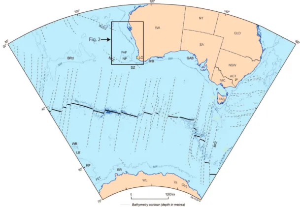
Fig. 1. Regional structural elements map of the Western Australian margin displaying the location of structural features that have led to the development of the Mentelle Basin. BRd = Broken Ridge; BR = Bruce Rise; DZ = Diamantina Zone; N = Naturaliste Plateau; NFZ = Naturaliste Fracture Zone; LC = Leeuwin Complex; BrB = Bremer Basin; GAB = Great Australian Bight; GC = Gawler Craton; BFZ = Balleny Fracture Zone; MR = Macquarie Ridge; WR = Williams Ridge; LB = Labuan Basin; KP = (southern) Kerguelen Plateau; WL = Wilkes Land; TA = Terre Ad´elie; GVL = George V Land. WA = Western Australia; NT = Northern Territory; SA = South Australia; QLD = Queensland; NSW = New South Wales; ACT = Australian Capital Territory; VIC = Victoria; TAS = Tasmania; PET = Princess Elizabeth Trough; WZFZ = Wallaby-Zenith Fracture Zone; PAP = Perth Abyssal Plain (modified from Direen et al., 2011).
A basement ridge in the southern part of the Naturaliste Plateau separates the Mentelle Basin from the Diamantina Zone (DZ) to the south (Halpin et al., 2008) (Fig. 1), whereas in the North, the basin merges with the Perth Abyssal Plain (Fig. 2). Interpretation of seismic and gravity data suggested that the Mentelle Basin probably formed dur-ing Late Jurassic-Early Cretaceous riftdur-ing (Borissova, 2002; Borissova et al., 2010a, b; Johnston et al., 2010).
In this study, we present the results of the reprocessing and interpretation of the older S18, “Petrel” and S280 2-D data sets, which are combined with more recent high-quality 2-D multi channel seismic data. Interpretation of this revised and expanded dataset allows an appraisal of the structural history of the Mentelle Basin with a greater degree of accuracy and certainty in comparison to previous studies, which were un-dertaken on a regional scale (Borissova, 2002; Bradshaw et al., 2003). In addition, we have provided insights into pale-oenvironemntal conditions prior to, during, and subsequent to Gondwana fragmentation in the Late Cretaceous.
2 Geological setting
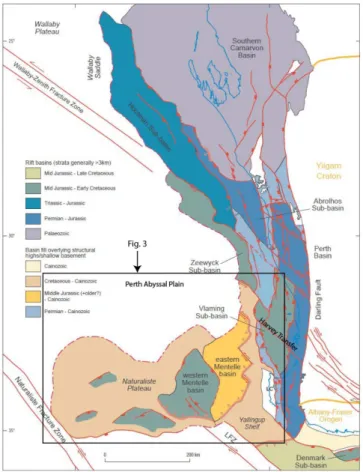
Fig. 2. Structural elements map of the area surrounding the Mentelle Basin. LFZ = Leeuwin Fracture Zone (modified from Bradshaw et al., 2003).
The Argo AP – Wallaby-Zenith Fracture Zone rifted mar-gin to the north is volcanic in nature (Planke et al., 2000; Direen et al., 2007, 2008) (Figs. 1 and 2). South of the Houtman Sub-basin (Fig. 2) this margin becomes more com-plex, stepping westward across the basement-controlled Har-vey Transfer Zone (Bradshaw et al., 2003), into the Mentelle Basin and the southern part of the Perth Basin (Fig. 2). The Vlaming Sub-basin is separated from the true margin by the crystalline basement high of the Leeuwin Complex and the Yallingup Shelf (Figs. 1 and 2).
This Valanginian-Late Hauterivian Australian-Antarctic conjugate rifted margin with India then stepped westward again to the western side of the Naturaliste Plateau-Bruce Rise and originally continued into the Princess Elizabeth Trough (Fig. 1) and farther west into the Enderby Basin. Here, the oldest true seafloor spreading anomalies are M9 (133 Ma – Hauterivian: timescale of Gradstein et al., 2004) (Stagg et al., 2004, 2005, 2006; Gaina et al., 2007), which are associated with seaward dipping reflector sequences (indica-tive of a volcanic margin) from the western flank of Bruce Rise to the Princess Elizabeth Trough (Stagg et al., 2006) (Fig. 1). These latter features predate Kerguelen Plateau vol-canism and are associated with anomaly “M4” (= M5 of Ogg and Smith, 2004,∼130 Ma: Barremian).
The character of the Perth margin to the north of the Mentelle Basin is not well constrained (Bradshaw et al., 2003), but is characterized by distribution of on and offshore volcanic rocks of the Bunbury Basalt (Frey et al., 1996; Cof-fin et al., 2002; Ingle et al., 2004; Gorter and Deighton, 2002) and is also considered to be a volcanic margin (e.g. Menzies et al., 2002). The Bunbury Basalt contains two geochemical age groupings: the older “Casuarina type” is 132.2±0.3 Ma (Hauterivian) and the younger “Gosselin type” is 123 Ma (Aptian) (Frey et al., 1996). The Gosselin type has been cor-related with the Rajmahal Traps of eastern India (Coffin et al., 2002), which are dated at 118.1±0.3 Ma (Kent et al., 1997, 2002) and are thought to be linked to mantle plume ac-tivity associated with the formation of the Kerguelen Plateau (Kent et al., 1997, 2002; Coffin et al., 2002).
From the Middle Jurassic during rifting and breakup of Greater India from Australia-Antarctica, the proto-Southern Rift System (SRS) (Stagg et al., 1990) situated south and east of the Mentelle Basin was undergoing extension. Syn-rift successions were deposited in the SRS at this time (Totterdell et al., 2000) and on the Naturaliste Plateau (Burkle, 1967; Borissova, 2002).
At around 95 Ma (Cenomanian) (Duncan, 2002; Coffin et al., 2002) there was mafic volcanism and the onset of rift-ing of the Broken Ridge microcontinent from the Kerguelen Plateau, west of the Naturaliste Plateau (Royer and Coffin, 1992; Tikku and Cande, 1999, 2000). Final breakup be-tween these features appears to have taken place at C34 time (Coniacian-Santonian: ∼85 Ma) (Tikku and Cande, 2000; Tikku and Direen, 2008). This ultimately resulted in the gradual propagation of the Southeast Indian Ridge System (e.g. Royer and Coffin, 1992; Gaina et al., 2007) to the southeast, forming a new magma poor margin and a con-tinent ocean transition zone in the Diamantina Zone, south of the Mentelle Basin (Direen et al., 2008; Beslier et al., 2004) (Figs. 1 and 3), younging to the east (Tikku and Di-reen, 2008). In summary, the Mentelle Basin is a rifted continental margin basin, located at the southern end of the Hauterivian-Barremian volcanic margin formed between In-dia and Australia-Antarctica. To the south, the Mentelle Basin is cross-cut by the younger Turonian-Maastrichtian magma-poor margin formed between Australia and Antarc-tica.
3 Geophysical data 3.1 Data acquisition
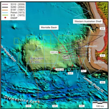
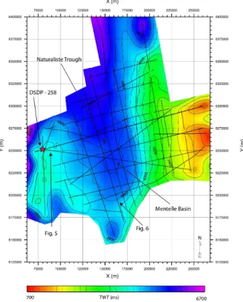
Fig. 3. Bathymetric map of the Mentelle Basin situated off-shore Cape Leeuwin. The positions of the 2-D seismic surveys together with borehole locations are shown (modified from Bor-rissova, 2002).
transparent sedimentary cover above the acoustic basement defined by a rough, strongly reflecting surface (Petkovic, 1975). The first dense seismic program was the 1972 re-gional Geoscience Australia Continental Margins Survey 18. This survey consisted of a continuous set of seismic pro-files, 8 orientated north-south and a further 9 aligned east-west (Fig. 3), supplemented with continuous gravity, mag-netic and bathymetric data. In the following year, the Shell Petrel Development Survey acquired four long profiles in ap-proximately north-south orientations across the Naturaliste Plateau and Mentelle Basin (Fig. 3). These profiles were in-tersected by two east-west trending profiles that terminated on the Yallingup Shelf and are a subset of the Petrel survey that comprised a large series of overlapping profiles around the western and southern Australian margins. The older Shell Petrel Development Survey was acquired with a 1090 in3 air-gun array and a digital recording streamer, yielding a nom-inal fold of coverage of 24 with a 50 m common midpoint spacing image. No further seismic data was collected until 1997, when a single deep (16 s TWT) profile was undertaken as part of Geoscience Australia Survey 187, shot across the Diamantina Zone up on to the Naturaliste Plateau (Fig. 3).
Geoscience Australia survey S280 was acquired in 2004 using a tuned 4900 in3 airgun array energy source and a 636 channel 7950 m seismic streamer digital recording sys-tem yielding a nominal fold of coverage of 80 with a 6.25 m common midpoint spacing. Seismic profiles extend onto the Western Australian Shelf and across the crystalline Yallingup
Shelf into the heavily faulted Vlaming Sub-basin (Figs. 2 and 3). Some seismic profiles pass close to borehole DSDP-258 on the eastern edge of the Naturaliste Plateau (Fig. 3), pro-viding an important geological correlation tie-point for the fi-nal processed seismic stacked sections. In 2009, Geoscience Australia survey S310 was acquired (Borissova et al., 2010a). The S310 seismic survey was integrated with the older S280, S18 and Petrel surveys (Fig. 3) and borehole data to reap-praise the stratigraphy, structural and depositional history of the Mentelle Basin. All seismic profiles displayed within have a vertical scale in s TWT.
4 Methodology
4.1 Seismic data processing
Raw shot records for the S18, “Petrel” and S280 seismic re-flection surveys (Fig. 3) were reprocessed. Firstly, we present the processing sequence applied to the high-quality S280 sur-vey that yielded high-resolution images of the sub-surface geology for subsequent re-interpretation (Fig. 4). Secondly, we present the processing of the older S18 and “Petrel” seis-mic surveys that gave poorer, but still significantly improved, final time-migrated stacked sections, which were used for closing the loops of interpreted horizons.
The acquisition set-up of the S280 survey produced a high-quality dataset; however, the raw shots had to be conditioned with a 5 Hz @ 48 dB/octave low-cut filter to curtail spuri-ous low-frequency internal instrumentation noise and ran-dom swell noise bursts. Using a minimum of processing steps, the objective was to maximise the temporal resolution of the thick Mentelle Basin sedimentary succession.
Two non-standard zero-phase filters were designed to re-move the secondary source bubble pulse and frequency limit-ing ghost notches from the seismic data. In a stacked section, the secondary source bubble pulse is exhibited as a broad event sub-parallel to the seabed reflection cross-cutting pri-mary geological reflections and potentially can be misinter-preted as a methane hydrate layer. The source debubble fil-ter was applied to all shot records early in the processing sequence before demultiple, whereas the deghost filter was convolved with un-migrated post-stack data producing a flat amplitude spectrum of up to 4 octaves.
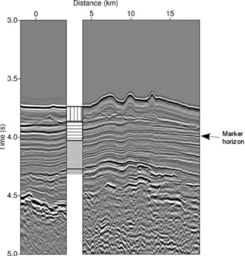
Fig. 4.DSDP-258 borehole data tied to the S280-501 seismic pro-file (seismic propro-file marked Fig. 5 in Fig. 3). The seismic propro-file to the left of the borehole represents the original data quality be-fore reprocessing. The seismic profile to the right of the borehole shows the improved quality after data reprocessing. The marker horizon highlighted at about 4 s TWT marks a reflection doublet that is not resolvable on the original data, which after reprocessing is seismically resolvable across the whole Mentelle Basin. Within the lithological interpretation, vertical hatching represents 114 m of Miocene deepwater carbonates and oozes; horizontal hatching 171 m of limestones and chalks interdispersed with chert bands; wavy hatching Cretaceous black clays and the basal stippled region represents 11 m of Lower Cretaceous glauconitic sands (from Sar-gent et al., 2011).
reflection point smear was reduced by a Fourier domain im-plementation of dip moveout (Hale, 1984). The optimum P-wave stacking velocity field was interactively picked at 1 km intervals post-dip moveout. Post-stack time and spatially varying bandpass filtering suppressed unwanted spurious low and high-frequency noise, whereas spherical divergence and absorption wave energy loss was compensated by applying a smooth inverse amplitude decay curve along the length of each profile. The Kirchhoff time-migration algorithm was well suited to smooth Mentelle Basin P-wave stacking ve-locity field (Yilmaz, 2001). Prior to the time-migration pro-cess FX deconvolution (Canales, 1984) was required to pre-vent the relocation of out-of-plane diffractions destroying the continuity of the shallow geology.
The processing sequence applied to the Shell Petrel De-velopment Survey was the same as that developed for the S280 survey, although the parameters were tailored to suit
the lower data quality and narrower frequency bandwidth. The short 2400 m streamer favoured the use of the Karhunen-Lo`eve transform (Jones and Levy, 1987) to suppress multi-ple energy, rather than Radon demultimulti-ple. To aid the geo-logical interpretation, the Petrel final time migrated sections were amplitude, phase and time matched to the S280 survey (Bishop and Nunns, 1994).
The Geoscience Australia Continental Margins Survey 18 raw 6-channel shot records dataset are of very low quality. Filters were designed to compress the complex 100 ms long 12 KJ sparker energy source wavelet. Additional temporal resolution improvement was provided by post-stack zero-phase spiking deconvolution. Sophisticated demultiple or dip moveout processing was not applied to the S18 dataset.
5 Seismic observations
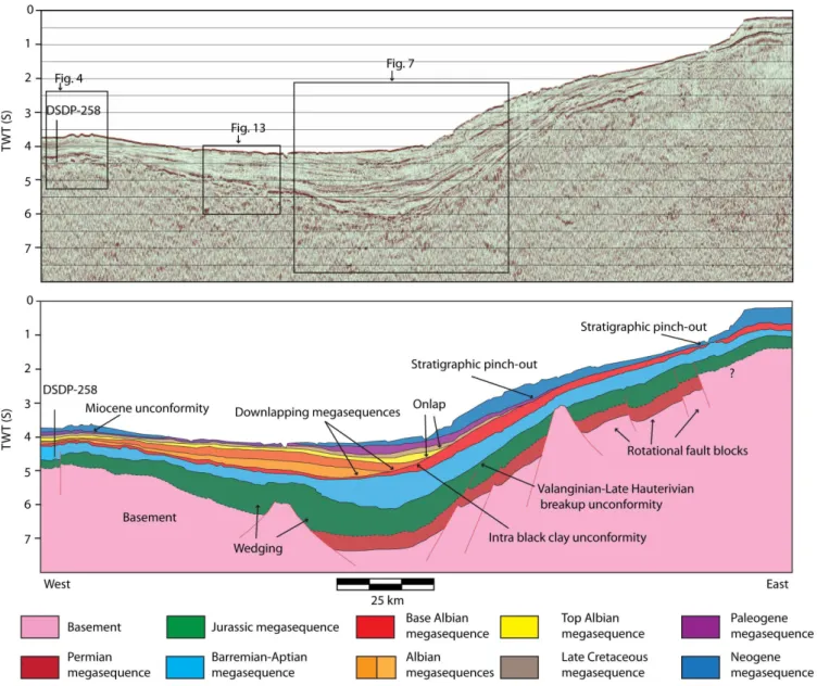
The newly processed seismic data reveal at least 6.6 s TWT and up to a maximum of 7.8 s TWT of sedimentary column within the Mentelle Basin (Figs. 5 and 6). Major uncon-formities and seismic packages through the section that can be tied to the DSDP-258 borehole, together with regional variations in seismic character, have allowed us to divide the stratigraphy into major seismically derived tectonostrati-graphic megasequences (Figs. 5 and 6). We describe each of these seismic megasequences and major unconformities be-low with regard to the stratigraphy and geological history of the Mentelle Basin from youngest to oldest respectively.
5.1 Neogene (Miocene-Quaternary) megasequence
The youngest megasequence in the Mentelle Basin com-prises low-amplitude, thin, seafloor parallel reflections (Fig. 5). Seismic data analysis corroborates the borehole data that Neogene beds are regionally unconformable with under-lying Cretaceous sediments. Neogene sediments are associ-ated with deepwater carbonate oozes and pelagic sedimen-tation across the Mentelle Basin region. This megasequence typically forms a thin veneer across the basin reaching a max-imum thickness of 0.5 s TWT within the main depocentre.
5.2 Miocene unconformity
Fig. 5. (A) Uninterpreted dip section through the Mentelle Basin and (B) interpreted section of (A) depicting the architecture and char-acteristic of seismic megasequences, which constitute the Mentelle Basin fill. Basement structure is also displayed. A series of major unconformities are located within the centre of the Mentelle Basin upon which numerous megasequences onlap and pinchout.
low-resolution old vintage S18 and Petrel surveys. The geological time difference across this unconformity varies, reaching a maximum of ∼10 My in the central area of the Mentelle Basin where thin Oligocene reflections terminate against the Miocene unconformity (Fig. 7).
5.3 Palaeogene megasequence
Adjacent to the slope of the Yallingup Shelf, a ∼350 ms TWT thick sub-basin, consisting of Oligocene and Eocene sediments, is seen to onlap onto the underlying Cretaceous megasequence (Fig. 7). Within this sub-basin, Eocene sedi-ments are represented by a series of dipping reflections with a decreasing easterly dip, whose upper surfaces abruptly
Fig. 6.(A) Uninterpreted and (B) interpreted strike line through the Mentelle Basin depicting the architecture of both the basement structure and seismically defined megasequences. Note the presence of a large inverted basement fault block situated close to the centre of the strike line.
sub-basins aside, the Palaeogene megasequence is character-istically thin across the Western Australian Shelf, draped un-conformably on the underlying Cretaceous megasequences.
5.4 Late Cretaceous- Eocene megasequences
In the vicinity of the DSDP-258 borehole (Fig. 3) situated at ∼3.5 s TWT are a couplet of high-amplitude reflection com-binations, which are identified as Turonian-Santonian chalk beds from the DSPD-258 borehole (Figs. 4 and 5). Region-ally, these beds are relatively thin, ranging from close to
Fig. 7.(A) Uninterpreted and (B) interpreted seismic line showing the seismic characteristics and architecture of megasequences within the central Mentelle Basin.
reflections downlapping onto a sharp high-amplitude event whose acoustic impedance contrast is caused by Albian black clays and Turonian-Santonian chalk beds.
Immediately underlying the high-amplitude chert and chalk bands are a series of low amplitude parallel reflections. The contact between the Turonian-Santonian chalk and un-derlying black clays, dated Albian in age, is seismically dif-fuse. Close to borehole DSDP-258 the contact is represented by a 30 m gradational interface resulting in this boundary
Fig. 8.TWT map of the basal reflection that defines the Base Albian megasequence.
The basal sedimentary succession intersected by borehole DSDP-258 is dated as Barremian-Aptian in age. On seis-mic data this succession is represented by washed-out sub-parallel seismic events of variable amplitudes (Figs. 4 and 5). DSDP-258 borehole data indicate that this succession is com-posed of interbedded silty sandy mudstones (Fig. 4). This succession thickens eastward to∼1 s TWT at the base of the main Mentelle Basin depocentre (Fig. 7). The Barremian-Aptian megasequence can be correlated to adjacent con-temporaneous sediments: a Cretaceous shale logged in the Vlaming Sub-Basin (e.g. Fig. 2). The Barremian-Aptian megasequence pinches out on the eastern slopes of the Nat-uraliste Plateau, although equivalent age deposits are inter-preted to be in small discrete rift basins present on the Nat-uraliste Plateau (Borissova, 2002). These deposits probably have a different lithology since they are expressed seismi-cally by a stronger, more defined reflection character when compared to Barremian-Aptian sediments imaged around DSDP-258 borehole (Figs. 5 and 7).
The internal architecture of the Cretaceous megasequences is not as homogeneous as it appears in the stratigraphy in-tersected by the DSDP-258 borehole, or on seismic profiles adjacent to it. The Cretaceous megasequences all wedge and thicken eastwards within the central Mentelle Basin depocenter and display considerable heterogeneity in their
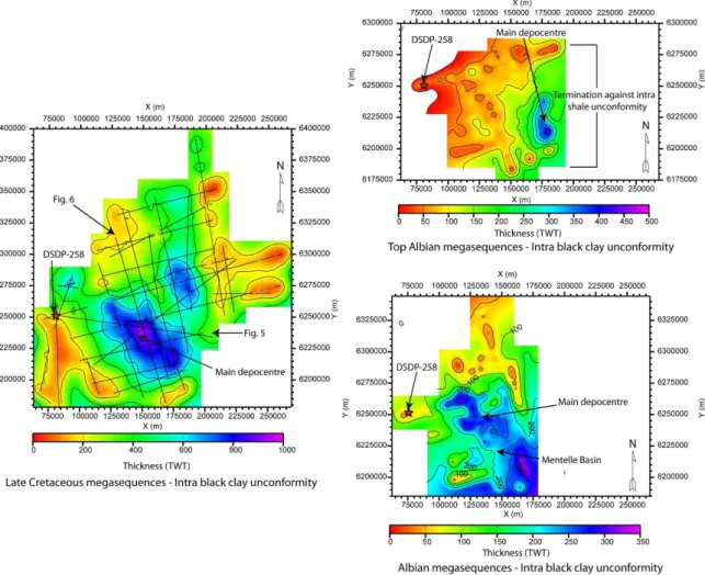
internal architecture as numerous unconformities, down-lapping and ondown-lapping reflection terminations are imaged. Where the combined thicknesses of the Cretaceous megase-quences reach a maximum thickness of 900 ms TWT, within the central depocentre (Fig. 9), a thick succession of organic rich black clays has been deposited, which correlates with Albian black marine mudstones within the DSDP-258 bore-hole.
Overlying the base Albian black clay reflection in the cen-tral Mentelle Basin is a high-amplitude reflection combi-nation, which dramatically cuts up-section over the West-ern Australian Shelf and typically separates underlying high-amplitude reflections from overlying eastward dipping, poorly resolved seismic reflections (Figs. 7 and 10). These eastward dipping reflections can be subdivided into three packages that onlap, downlap and terminate against the high-amplitude reflection combination. This marks the high-amplitude reflection combination as a major unconformity within the Albian clay, which does not coincide with the cor-related base Albian clay interval. From herein this uncon-formity will be referred to as the “intra black clay unconfor-mity”, based upon its location within the stratigraphy. This unconformity pinches-out upon the Western Australian Shelf (Fig. 10).
The Late Cretaceous megasequence in the central Mentelle Basin onlaps and terminates against a distinct, high-amplitude reflection which continues up and over the Yallingup Shelf (Fig. 7). This megasequence is bound by both the top reflection defining the underlying downlapping megasequence and the intra black clay unconformity. It reaches a maximum thickness of 0.5 s TWT in the central depocentre and thins and pinches out over the Western Aus-tralian Shelf. Reflections situated internally within this pack-age terminate against the top reflection of the underlying downlapping megasequence, which locally, also marks this top defining reflection as an unconformity within the central Mentelle Basin.
The three downlapping Cretaceous megasequences all thin westward, with reflections terminating upon the intra black clay unconformity. Cumulatively these three downlapping megasequences reach a maximum thickness of 0.8 s TWT in the main depocentre (Fig. 9). Here, the internal seismic character of the Albian black clays has a staccato appearance, reflection events are discontinuous and offset vertically on the millisecond scale at frequent intervals laterally (Fig. 7). These small scale features are the 2-D seismic representation of three-dimensional (3-D) polygonal faults that are common in thick deposits of fine grained materials (e.g. Cartwright and Dewhurst, 1998).
Fig. 9.Isochron maps for the Cretaceous black clay megasequences. Representative thickness changes highlighted within each isochron are interpreted to reflect changes in thermal contraction (flexure), subsidence and accommodation space.
5.5 Valanginian-Late Hauterivian breakup unconformity
A high-amplitude reflection situated at∼4.5 s TWT (Figs. 5 and 7) is observable laterally across the Mentelle Basin (Fig. 11). This reflection displays numerous breaks in lateral continuity and is vertically offset indicating the presence of faults. This extensive horizon is interpreted as a Valanginian-Late Hauterivian unconformity associated with the breakup between India-Madagascar and Australia-Antarctica (Borissova, 2002; Direen et al., 2008). This un-conformity is thought to constitute a layer of volcanics, an interpretation that is reinforced from P-wave velocity analy-sis. P-waves travel typically through the Neogene-Paleogene pelagic deposits, Turonian-Santonian chalk beds and Al-bian black clays at∼2000 ms−1and through the Barremian-Aptian silty sandy mudstones at ∼2500 ms−1 (Fig. 12). The base of the Barremian-Aptian silty sandy mudstones is marked by a dramatic increase in P-wave velocity to ∼4000 ms−1, which is interpreted to reflect a hard crystalline lithology. Isolated high-amplitude reflections that curl up
at the edges often overlie the Valanginian-Late Hauterivian breakup unconformity. The nature of these reflections is dis-cussed further below.
Fig. 10. TWT map of the intra black clay unconformity (within the Base Albian megasequence) upon which younger Cretaceous megasequences onlap.
5.6 Jurassic megasequence
A series of sub-parallel reflections are imaged below the high-amplitude Valanginian-Late Hauterivian breakup un-conformity (Figs. 5 and 7). Seismic resolution below the Valanginian-Late Hauterivian breakup unconformity drops rapidly as a consequence of the overlying volcanic deposits. The Jurassic megasequence has a thickness of∼0.8 s TWT and displays numerous breaks in lateral reflection continu-ity. Reflections are vertically offset along high angle dis-continuities that indicate the presence of normal fault traces. The upper tip points of faults appear to terminate at the Valanginian breakup unconformity. These vertical reflection discontinuities resemble the geometry of rotated fault blocks. Jurassic reflection packages wedge and thicken into the hang-ing walls of fault blocks and are interpreted to be deposited during fault growth, coeval with Jurassic syn-rift extensional structures. Overlying contacts appear erosional where they terminate against the Valanginian-Late Hauterivian breakup unconformity (Fig. 6). This megasequence is laterally dis-continuous throughout the Mentelle Basin, highly rotated and primarily situated within major depocentres. We in-terpret this Jurassic section to be contemporaneous with the Perth Basin fluvial sediments, the Eneabba Formation through to the cyclical muddy sandstone beds of the Yara-gadee Formation (Iasky, 1993; Song and Cawood, 2000).
Fig. 11. TWT map of the Valanginian-Late Hauterivian breakup unconformity. This extensive unconformity can be mapped across the entire basin and marks a change from volcanic associated rifting to thermal subsidence and eventual deposition of black clays.
5.7 Permian megasequence
Fig. 12. Stacking and interval velocity trends for a typical depth profile through the Mentelle Basin. Note the significant increases in interval velocity associated with the Valanginian-Late Hauteriv-ian breakup unconformity (volcanic composition) and deeper buried more compacted Jurassic sediments.
thickens. This thickening is interpreted to represent growth strata, identifying that deposition was synchronous with rift-ing, indicative of the increase in accommodation created in the hanging walls of normal faults. As intervals at this depth are generally dominated by seismic noise, where Permian age reflections are interpreted the contact with underlying Permo-Triassic deposits and/or the crystalline basement is approximated where coherent reflections are absent.
6 Interpretation
6.1 Structural reappraisal of the Mentelle Basin
Improving the seismic resolution of the older 2-D seismic data sets through reprocessing and combining reprocessed data with recently acquired 2-D data allowed the accurate definition of seismic megasequences to be correlated across the Mentelle Basin. This enabled the structural history of the Mentelle Basin to be reconstructed. Deep seated Juras-sic and Permian megasequences are coincident with an early period of rifting and basin extension, wedging growth ge-ometries show that Jurassic and Permian deposition was syn-kinematic with respect to fault growth. Erosional con-tacts between Permian and Jurassic megasequences and the Valanginian-Late Hauterivian breakup unconformity sug-gests subareal exposure of the India-Australian margin be-fore breakup began.
The increase in P-wave velocity across the Valanginian-Late Hauterivian breakup unconformity is consistent with the occurrence of an igneous lithology, likely to be basaltic in composition. The Valanginian-Late Hauterivian breakup unconformity is related to major rifting and volcanism in-volving the separation of India-Madagascar and
Australia-Antarctica. The isolated high-amplitude reflections that lie above the Valanginian unconformity displaying “smiles” are interpreted to be sills associated with breakup volcanism (Di-reen et al., 2008). The thickness of the basalt is assumed to be relatively thin, based on the fact that underling Permian and Jurassic megasequences are imaged, and because thick basaltic flows are known to degenerate seismic signal dra-matically. Experience from the north-west Atlantic shows that hard compact basaltic horizons are difficult to seismi-cally penetrate without special seismic acquisition param-eters (Maresh and White, 2005) and/or special processing (Gallagher and Dromgoole, 2008).
It is conceivable that the high-amplitude kilometre-scale structures imaged upon the Valanginian-Late Hauterivian breakup unconformity reflection (Fig. 13) are of volcanic origin, contemporaneous with the Casuarina-type Bunbury Basalts, which have been dated at 132 Ma (Hauterivian) (Frey et al., 1996), 4 to 8 m.y. younger than the Valanginian-Late Hauterivian breakup age. Similar structures are ob-served in seismic data from the northern Perth Basin and have been interpreted as volcanic cinder cones (Gorter and Deighton, 2002). Degradation of the seismic signal occurs in places beneath the kilometre-scale structures; however, no volcanic feeder systems (dykes, climbing sills) (Direen et al., 2008) have been imaged. Coherent layer parallel reflections are imaged beneath some of these mounds, suggesting that such igneous intrusive features may be absent, although we caution that at the scale of observation and in the limitations of the signal to noise ratio that such features may be essen-tially undetectable, especially if they are sub-vertical.
Fig. 13. Seismic line depicting moundal structures lying above the Valanginian-Late Hauterivian breakup unconformity. The extensive differential compaction system that has developed above the moundal structures implies that they are composed of a hard compact lithology.
area (Fig. 9). Beyond borehole DSDP-258, this sediment package pinches out on the eastern flanks of the Natural-iste Plateau, suggesting the latter feature may have been sub-aerial throughout the Barremian and Aptian.
The post breakup phase is represented by the thick succes-sion of Cretaceous black clays. A critical observation is the presence of the downlapping and onlapping seismic megase-quences and major unconformities, which define the internal architecture of Albian black clay megasequences in the cen-tral Mentelle Basin (Figs. 5 and 6). Previously, the Albian clays were interpreted to have been deposited in a thermally subsiding, open marine environment (Borissova, 2002), but the seismic megasequences imaged clearly show that basin history was more complex.
The Aptian-Barremian megasequence saw a change in de-position to open marine with the dede-position of silty mud-stones. Through the Albian, the Mentelle Basin was un-dergoing extension and subsidence as a consequence of the underlying the Kerguelen hotspot. The Kerguelen hotspot was particularly active throughout the Albian with an es-timated magma flux of 0.9 km3yr−1 (Coffin et al., 2002), which rapidly built-up a massive basaltic platform. Heat flux from the Kerguelen hotspot is a possible cause for the thin continental crust in the vicinity of the Mentelle Basin as predicted by Direen et al. (2008). By the time of max-imum magma output, plate motion resulted in the Kergue-len hotspot moving westwards relative to the Mentelle Basin
leading to thermally relaxation-induced subsidence creat-ing the central depocenter. Sediment input initially began from the east, with ferruginous source material eroded from the Bunbury Basalts, as determined by geochemical analy-sis (Luyendyk and Davies, 1974). The Aptian-Barremian megasequence is relatively thin and its upper surface is char-acterised by the intra black clay unconformity. This uncon-formity reflects a distinct change from open marine condi-tions and represents either: (1) a brief lowstand event, which led to an influx of coarse grained turbiditic material into the basin; or (2) margin flexure, as a consequence of thermal subsidence and/or sediment loading, which could have gen-erated a turbidity flow in shelfal regions if accommodation was low.
Throughout the Cenomanian, the region rapidly subsided to the present water depth of ∼3000 m. This event is recorded in the stratigraphy in borehole DSDP-258 as a 30 m transition zone from black clays to chalk beds (Fig. 4). It is hypothesised that rapid subsidence was caused by a loss of thermal buoyancy as the Kerguelen hotspot continued to move southwestwards (Weis et al., 2002).
The regional Eocene unconformity represents the breakup between Australia and Antarctica, an event that was highly diachronous (Tikku and Direen, 2008). South of the Mentelle Basin, breakup appears to have started prior to ∼95 Ma (Beslier et al, 2004) and on the southern flank of the Natu-raliste Plateau is recorded as a hiatus between Palaeocene-Eocene deposits and underlying Turonian-Santonian chalk beds (Fig. 7) as detailed near borehole DSDP-258 (Fig. 4).
A later tectonic event disturbed the Mentelle Basin and surrounding region more dramatically. Middle Eocene mag-netic anomalies present in the oceanic crust south of the east-west orientated 250 km wide Diamantina Zone (Tikku and Cande, 1999) (Figs. 1 and 3) correspond to the separation of the Diamantina Zone and the Labuan Basin and the onset of fast spreading between Australia and Antarctica (Cande and Mutter, 1982; Royer and Coffin, 1992). The rapid northward motion of Greater India began∼70 Ma and once Greater In-dia slowed in its northward migration (∼50 Ma) the onset of fast spreading between Australia and Antarctica initiated (Cande and Mutter, 1982). The Middle-Eocene fast spread-ing event is interpreted to have tilted the Mentelle Basin re-gion to the north. Tilting also appears to have reactivated some basement faults, including those controlling the ge-ometry of the main depocentre within the Mentelle Basin. Figure 6 shows apparent inversion of a basement fault block where Jurassic sediments are in contact with Albian age sed-iments.
Subsequent to the establishment of the Eocene fast spread-ing, Australia’s southern margin became a stable trailing margin (Totterdell et al., 2000). Miocene to Holocene de-posits form a thin (200 ms TWT) veneer across the Mentelle Basin and Naturaliste Plateau and are interpreted to have been deposited on the stable trailing margin.
7 Discussion
7.1 Climatic implications
Geological records show that the Jurassic through to the Cre-taceous was an exotic world compared to the present day. Tropical sea surface temperatures in the Late Albian to Tur-onian may have reached 35◦C (Wilson et al., 2002); high-latitude sea surface temperatures were possibly in excess of 20◦C (Huber et al., 1995). Atmospheric CO2concentrations are thought to have been greater than 4000 ppm (Bice and Norris, 2002) approximately 10 times the present day CO2 level. However, the existence of substantial carbonate
pro-duction at high palaeolatitude∼60◦S, if proven, would
pro-vide key insights into local oceanographic conditions during rifting. Climate modelling predicts temperatures of∼30◦C
in the interior of the Australian-Antarctic land mass during the Early Cretaceous winter months (Fluteau et al., 2007). The high latitude Albian section within the Mentelle Basin may record such cycles, but this remains to be tested more fully.
8 Conclusions
Integration of new and vintage 2-D seismic datasets from the Mentelle Basin provided additional insights into the structural evolution of this poorly known and underexplored basin and has revealed hitherto unknown tectonostratigraphic features. Coherent seismically resolvable reflections form-ing the basal seismically defined megasequences are nested Jurassic-Lower Cretaceous and Permian rift basins. Truncat-ing these meagasequences is a major regional angular uncon-formity, the Valanginian-Late Hauterivian breakup unconfor-mity, which is overlain by constructional mounds that may be carbonate reefs, as opposed to a more conventional interpre-tation of volcanic features.
Above the Valanginian-Late Hauterivian breakup uncon-formity are a series of Cretaceous megasequences, which are separated by major unconformities. A thick succession of Albian age black clays is punctuated by the intra black clay unconformity. The intra black clay unconformity may reflect significant but short-lived lowstand event or margin flexure before a return to open marine conditions. Black clay de-position reflects the thermal contraction of the rifted margin basin, punctuated by thermal thinning events due to the pres-ence of the Kerguelen plume; breakup in the Southern Rift System to the south; and the onset of Middle-Eocene fast spreading in the Australian-Antarctic Basin. The geological architecture of the Mentelle Basin was determined by this complex rifting history and its proximity to the migrating Kerguelen hotspot.
The presence of substantial Cretaceous carbonate buildups at high palaeolatitude, if proven, would also provide valu-able data on local oceanographic conditions during and sub-sequent to continental breakup.
Dave Stevenson and Gary Wilkinson. We also thank Steven Cande and Gary Wilson for their constructive comments, which helped improve the quality of this manuscript.
Edited by: V. Sallar`es
References
Beslier, M. O., Royer, J. Y., Girardeau, J., Hill, P. J., Boeuf, E., Buchanan, C., Chatin, F., Jacovetti, G., Moreau, A., Munschy, M., Partouche, C., Robert, U., and Thomas, S.: Une large tran-sition continent-ocean en pied de marge sud-ouest australienne: premiers resultats de la campagne MARGAU/MD110, Bulletin Societe geologique Francaise, 175, 629–641, 2004.
Bice, K. L. and Norris, R. D.: Possible atmospheric CO2 ex-tremes of the Middle Cretaceous (late Albian-Turoninan), Pale-ooceanography, 17(4), doi:10.1029/2002PA000778, 2002. Bishop, T. N. and Nunns, A. G.: Correcting amplitude, time and
phase miss-ties in seismic data, Geophysics, 59, 946–953, 1994. Borissova, I.: Geological framework of the Naturaliste Plateau,
Geoscience Australia Record, 2002/20, 2002.
Borissova, I., Bradshaw, B. E., Nicholson, C, Struckmeyer, H. I. M., and Payne, D.: New exploration opportunities on the southwest Australian margin-deep-water frontier Mentelle Basin, APPEA J., 50, 1–13, 2010a.
Borissova, I., Bradshaw, B. E., Nicholson, C., Payne, D., and Struckmeyer, H. I. M.: Mentelle Basin – tectonic evolution con-trolled by of the combined extensional history of the Southwest-ern and SouthSouthwest-ern Australian margins, ASEG-PESA 21st Con-ference and exhibition, Sydney, 22—26 August 2010, Extended abstracts, 2010b.
Bradshaw, B. E., Rollet, N., Totterdell, J. M., and Borissova, I.: A revised structural framework for frontier basins on the south-ern and southwestsouth-ern Australian continental margin, Geoscience Australia Record, 2003/03, 2003.
Burkle, L. H., Saito, T., and Ewing, M.: A Cretaceous (Turonian) core from the Naturaliste Plateau. Deep-Sea Res., 14, 421–426, 1967.
Canales, L.: Random noise reduction: 54th Annual International Meeting, Society of Exploration Geophysicists, Expanded Ab-stracts, 525, 1984.
Cande, S. C. and Mutter, J. C.: A revised identification of the oldest sea-floor spreading anomalies between Australia and Antarctica, Earth Planet. Sci. Lett., 58, 151–160, 1982.
Cartwright, J. A. and Dewhurst, D. N. Layer-bound compaction faults in fine-grained sediments, GSA Bull., 110, 1242–1257, 1998.
Coffin, M. F., Pringle, M. S., Duncan, R. A., Gladczenko, T. P., Storey, M., M¨uller, R. D., and Gahagan, L. A.: Kerguelen hotspots magma output since 130 Ma, J. Petrol., 43, 1121–1139, 2002.
Direen, N. G., Borissova, I., Stagg, H. M. J., Colwell, J. B., and Symonds, P. A.: Nature of the continent-ocean transition zone along the southern Australian continental margin: a comparison of the Naturaliste Plateau, SW Australia, and the central Great Australian Bight sectors, in: Imaging, mapping and modelling continental lithosphere extension and breakup, edited by: Karner,
G. D., Manatschal, G., and Pinheiro, L. M., Geological Society (London) Special Publication, 282, 235–261, 2007.
Direen, N. G., Stagg, H. M. J., Symonds, P. A., and Colwell, J. B.: The architecture of volcanic rifted margins: new insights from the Exmouth-Gascoyne margin: Western Australia, Aust. J. Earth Sci., 55, 325–347, 2008.
Direen, N. G., Borissova, I., Stagg, H. M. J., Colwell, J. B., and Symonds, P. A.: Nature of the continent – ocean transition zone along the southern Australian continental margin, in: Imaging, mapping and modelling continental lithosphere extension and breakup, edited by: Karner, G. D., Manatschal, G., and Pinheiro, L. M., Geological Society (London) Special Publication, 282, 235–261, 2007.
Direen, N. G., Stagg, H. M. J., Colwell, J, B., and Symonds, P. A.: Dominant Symmetry of a Conjugate Southern Australian and East Antarctic MagmaPoor Rifted Margin Segment. Geochem. Geophys. Geosys., (G3) 12(2) doi:10.1029/2010GC003306, 2011.
Duncan, R. A.: A time frame for construction of the Kerguelen Plateau and Broken Ridge, J. Petrol., 43, 1109–1119, 2002. Fluteau, F., Ramstein, G., Besse, J., Guirand, R., and Masse, J.
P.: Impacts of palaeogeography and sea level changes on Mid-Cretaceous climate, Palaeogeogr., Palaeocl., Palaeoecol., 247, 357–381, 2007.
Frey, F. A., McNaughton, N. J., Nelson, D. R., delaeter, J. R., and Duncan, R. A.: Petrogenesis of the Bunbury Basalts, Western Australia: interaction between the Kerguelen plume and Gond-wana lithosphere?, Earth Planet. Sci. Lett., 176, 73–89, 1996. Gaina, C., Mueller, R. D., Brown, B., Ishihara, T., and Ivanov, S.:
Breakup and early seafloor spreading between India and Antarc-tica, Geophys. J. Internat., 170, 151–169, 2007.
Gallagher, J. W. and Dromgoole, P. W.: Seeing below the basalt – offshore Faroes, Geophys. Prospect., 56, 33–45, 2008.
Gorter, J. D. and Deighton, I.: Effects of igneous activity in the offshore northern Perth Basin – evidence from petroleum explo-ration wells, 2-D seismic and magnetic surveys, in: Western Aus-tralian Basins Symposium III, edited by: Keep, M. and Moss, S. J., PESA, Perth, 875–899, 2002.
Gradstein, F. M., Ogg, J. G., and Smith, A. G.: A Geological Time Scale, Cambridge University Press, New York, 2004.
Hale, D.: Dip moveout by Fourier transform, Geophysics, 49, 749– 757, 1984.
Halpin, J. A., Crawford, A. J., Direen, N. G., Coffin, M. F., Forbes, C. J., and Borissova, I.: Naturaliste Plateau, offshore Western Australia: A submarine window into Gondwana assembly and breakup, Geology., 36, 807–810, 2008.
Hawkins, L. V., Hennion, J. F., Nafe, J. E., and Thyer, R. F.: Geo-physical investigation in the area of the Perth Basin, Western Australia, Geophysics., 30, 1026–1052, 1965.
Hayes, D. E., Frakes, L. A., and Barrett, P. J.: Shipboard site reports, site 264. Initial reports of the Deep Sea Drilling Project, Leg 28, Washington, D.C., U.S. Government Printing Office, 1975. Huber, B. T., Hodell, D. A., and Hamilton, C. P.: Middle-Late
Cre-taceous climate of the southern high latitudes: Stable isotopic ev-idence for minimal equator-to-pole thermal gradients, Geol. Soc. Am. Bull., 107, 1164–1191, 1995.
Geol., 209, 83–106, 2004.
Iasky, R. P.: A structural study of the Southern Perth Basin, Western Australia, Geological Survey of Western Australia, Report 31, 1993.
Johnston, S., Hackney, R., and Nicholson, C., Distribution of vol-canic facies and results from potential field modelling of the Mentelle Basin, southwestern Margin, Australia, ASEG-PESA 21st Conference and exhibition, Syndey, 22–26 August 2010, Extended abstracts, 2010.
Jones, I. F. and Levy, S.: Signal-to-noise ratio enhancement in mul-tichannel seismic data via the Karhunen-Lo`eve transform, Geo-phys. Prospect., 35, 12–32, 1987.
Jongsma, D. and Petkovic, P.: The structure of the Naturaliste Plateau and trough, The APPEA J., 17 Part 1, 3–12, 1977. Kent, R. W., Saunders, A. D., Kempton, P. D., and Ghose, N. C.:
Rajmahal basalts, eastern India: mantle sources and melt distri-bution at a volcanic rifted margin, in: Large Igneous Provinces: Continental, Oceanic and Planetary Flood Volcanism, edited by: Mahoney, J. J. and Coffin, M. F., American Geophysical Union Geophysical Monograph, 100, 145–182, 1997.
Kent, R., Pringle, M. S., M¨uller, R. D., Saunders, A. D., and Ghose, N. C.:40Ar/39Ar geochronology of the Rajmahal basalts, India and their relationship to the Kerguelen Plateau, J. Petrol., 43, 1141–1153, 2002.
Luyendyk, B. P. and Davies, T. A.: Shipboard site reports, site 258. Initial reports of the Deep Sea Drilling Project, Leg 26, Wash-ington, D.C., U.S. Government Printing Office, 1974.
Maresh, J. and White, R. S.: Seeing through a glass, darkly: strate-gies for imaging through basalt, First Break., 23(5), 27–33, 2005. Markl, R. G.: Further evidence for the Early Cretaceous breakup of Gondwanaland off southwestern Australia, Mar. Geol., 26, 41– 48, 1978.
Menzies, M. A., Klemperer, S. L., Ebinger, C., and Baker, J.: Char-acteristics of volcanic rifted margins, in: Volcanic Rifted Mar-gins, edited by: Menzies, M. A., Klemperer, S. L., Ebinger C., and Baker J., Geological Society of America Special Paper, 362, 1–14, 2002.
Metcalfe, I.: Gondwanaland dispersion, Asian accretion and evolu-tion of eastern Tethys, Aust. J. Earth Sci., 43, 605–624, 1996. Mihut, D. and Mueller, R. D.: Volcanic margin formation and
Mesozoic rift propagators in the Cuvier abyssal plain off West-ern Australia, J. Geophys. Res, B, Solid Earth and Planets., 103, 27135–27149, 1998.
Mutter, J. C., Larson, R. L., Buhl, P., Diebold, J. B., Alsop, J., Lorenzo, J. M., Mithal, R., Hopper, J., Falvey, D. A., Williamson, P. E., Brassil, F., and Northwest Australia Study Group: Exten-sion of the Exmouth Plateau, offshore northwestern Australia; deep seismic reflection/refraction evidence for simple and pure shear mechanisms, Geology., 17, 15–18, 1989.
Ogg, J. G. and Smith, A.: The geomagnetic polarity timescale, in: A Geologic Time Scale, edited by: Gradstein, F. M., Ogg, J. G., and Smith A., Cambridge University Press, pp. 589, 2004. Petkovic, P.: Origin of the Naturaliste Plateau, Nature, 253, 30–33,
1975.
Planke, S., Symonds, P. A., Alvestad, E., and Skogseid, J.: Seis-mic volcanostratigraphy of large volume basaltic extrusive com-plexes on rifted margins, J. Geophys. Res., 105, 19335–19351, 2000.
Powell, C. M., Roots, S. R., and Veevers, J. J.: Pre-breakup conti-nental extension in East Gondwanaland and the early opening of the eastern Indian, Ocean. Tectonophysics., 155, 261–283, 1988. Rafaelsen, B., Elvebakk, G., Andreassen, K., Stemmerik, L., Col-paert, A., and Samuelsberg, T. J.: From detached to attached carbonate buildup complexes-3D seismic data from the upper Palaeozoic, Finnmark Platfrom, southwestern Barents Sea, Sed. Geol., 206, 17–32, 2008.
Royer, J.-Y. and Coffin, M. F.: Jurassic to Eocene plate tectonic reconstructions in the Kerguelen Plateau region, in: Proceedings of the Ocean Drilling program, edited by: Wise, S. W., Schlich, R., and Julson, A. A. P., Scientific Results, 120, College Station, 1992.
Russell, B., Hampson, D., and Chun, J.: Noise elimination and the Radon transform: The Leading Edge, 9(10), 18–23, 1990. Sargent, C., Hobbs, R. W., and Gr¨ocke, D. R.: Improving the
inter-pretability of air-gun seismic reflection data using deterministic filters: A case history from offshore Cape Leeuwin, southwest Australia, SEG, 76(3), B113–B125, doi:10.1190/1.3554396, 2011.
Song, T. and Cawood, P. A.: Structural styles in the Perth Basin as-sociated with the Mesozoic break-up of Greater India and Aus-tralia, Tectonophysics., 317, 55–72, 2000.
Stagg, H. M. J., Willcox, J. B., Needham, D. J. L., O’Brien, G. W., Cockshell, C. D., Hill, A. J., Thomas, B., and Hough, L. P.: Basins of the Great Australian Bight region: geology and petroleum potential. Continental Margins Program Folio 5. Bu-reau of Mineral Resources, Geology and Geophysics and Depart-ment of Mines and Energy, South Australia, 1990.
Stagg, H. M. J., Alcock, M. B., Bernardel, G., Moore, A. M. G., Symonds, P. A., and Exon, N. F.: Geological framework of the outer Exmouth Plateau and adjacent ocean basins, Geoscience Australia Record, 2004/13, 2004.
Stagg, H. M. J., Colwell, J. B., Direen, N. G., O’Brien, P. E., Bernardel, G., Borissova, I., Brown, B. J., and Ishihara, T.: Ge-ology of the continental margin of Enderby and Mac. Robertson Lands, East Antarctica, Insights from a regional data set, Mar. Geophys. Res., 25, 183–219, 2005.
Stagg, H. M. J., Colwell, J. B., Borissova, I., Ishihara, T., and Bernardel, G.: The Bruce Rise Area, East Antarctica: Forma-tion of a Continental Margin near the Greater India – Australia – Antarctica Triple Junction, Terra Antarctica., 13, 3–22, 2006. Tikku, A. A. and Cande, S. C.: The oldest magnetic anomalies in
the Australian-Antarctic Basin, Are they isochrons? J. Geophys. Res., 104, 661–677, 1999.
Tikku, A. A. and Cande, S. C.: On the fit of Broken Ridge and Kerguelen Plateau, Earth Planet. Sci. Lett., 180, 117–132, 2000. Tikku, A. A. and Direen, N. G.: Comment on “Major Australian-Antarctic Plate Reorganization at Hawaiian-Emperor Bend Time”, Science, 321, 490–491c, 2008.
Totterdell, J. M., Blevin, J. E., Struckmeyer, H. I. M., Bradshaw, B. E., Colwell, J. B., and Kennard, J. M.: A new stratigraphic framework for the Great Australian Bight: starting with a clean slate, APPEA J., 40, 95–117, 2000.
Verschuur, D. J., Berkhout A. J., and Wapenaar, C. P. A.: Adap-tive surface-related multiple elimination, Geophysics., 57, 1166– 1177, 1992.
Weis, D., Frey, F. A., Schlich, R., Schaming, M., Montigny, R., Damasceno, D., Mattielli, N., Nicolaysen, K. E., and Scoates, J. S.: Trace of the Kerguelen mantle plume: Evidence from seamounts between the Kerguelen Archipelago and Heard Is-land, Indian Ocean. Geochem. Geophys. Geosys., G3 3(6), 1033, doi:10.1029/2001GC000251, 2002.
Wilson, P. A., Norris, R. D., and Cooper, M. J.: Testing the Cre-taceous greenhouse hypothesis using glassy foraminiferal calcite from the core of the Turonian tropics Demerara Rise, Geology., 30, 607–610, 2002.