Página | 775
https://periodicos.utfpr.edu.br/rbpd
Luis Guillermo Castillo Gonzalez
[email protected] Natural Resources and the Environment Study Center (CEMARNA). University of Pinar del Río. Pinar del Río Province, Cuba
Libys Martha Zúñiga Igarza [email protected] Faculty of Engineering, Civil Engineering degree. University of Holguín. HolguínProvince, Cuba
Iselys González López [email protected] Direction of International Relations. University of Pinar del Río. Pinar delRíoProvince, Cuba Niurka Castillo Rocubert [email protected] Natural Resources and the Environment Study Center (CEMARNA). University of Pinar del Río. Pinar del Río Province, Cuba
Vinelia Cordova Vázquez [email protected] Natural Resources and the Environment Study Center (CEMARNA). University of Pinar del Río. Pinar del Río Province, Cuba
Planning of the green system in Cuban
human settlements
ABSTRACT
Addressing the issues of landscape, agriculture, the green system, sustainability and its relations with urban and rural systems is an extremely complex task in itself, due to the characteristics of the development models implemented by humanity up to the present. A methodological instrument of territorial planning is proposed, contextualized in the Cuban reality, where agricultural areas are considered an important part of urban and peri-urban greening. This isbased on the principles of landscape ecology. The current urban and peri-urban agricultural development strategy is assumed by the territorial order as a process, which can transform the traditional urban model of Cuban cities and relations with their territories (city-countryside relationship); in parallel, agriculture takes on a multifunctional character in itself from the processes of urban and peri-urban agricultural transformation. From this perspective, it contributes to an edge for a sustainable city model, based on the ecosystem integration between urban and rural areas, built upon a local development that enables the protection of the territory.
Página | 776
INTRODUCTION
The themes of the landscape, agriculture, the green system and sustainability, are related to current environmental problems, based on the existing philosophical and conceptual relationship between the city and the countryside. The high degree of fragmentation and isolation that characterizes the green areas of cities requires an approach permittingthe creation of a network basedon natural and ecosystem relations; of green spaces at different scales, based on the natural ecological network, that dictates the structure of the site, as well as the landscape ecology approach, that conceptually allows a coherent and organic dialogue between the city and nature.
In the international debate and in political discourses, sustainability is becoming more pronounced, goingthrough and with a sense of urgency from a chimera to a paradigm in theory; however, there are few examples of implementation of sustainable development models given the complexity of the issue and the dependence on traditional structures (VENDITTELLI, 2000).
Particularly, the urban models of development and settlements in general are one of the most notable examples of human actions that according to the progress and civilization have ignored the complex laws that relate the society with nature. The so-called road to modernity makes cities today one of the most accurate ways for the destruction of the planet. In this expansion process they have gone from the compact metropolitan structures to the so-called diffuse city, which does not turn out to be a city because it is not urban or rural, expressing the decline, the marginality, the change in nature and the form not only of the city, but also of the agricultural territory that it invades.
Similarly, the high degree of fragmentation and isolation that characterizes urban green areas, require the formation of networks, from natural and ecosystem relationships at different scales depending on an ecological structure of the site.
Traditionally, the study of green areas in Cuba has been carried out within the evaluation of public spaces for the purposes of physical planning. One of the responses to the economic crisis and particularly the energy crisis has been the development of an urban and peri-urban agricultural model, whose scenarios are closely related to cities. In practice, part of the urban and peri-urban landscape of many cities has become productive agricultural zones without formally forming part of the public spaces within the green system.
The spontaneity of the process of introducing agriculture into the cities, in the face of urgent economic needs, did not allow for the elaboration of coherent urban or peri-urban projects by the institution responsible for territorial ordering in Cuba. Over the years, the committed areas have acquired important levels of engagement to their cities to which they provide fresh vegetables and vegetables at zero kilometer, materializing what an utopia means for any large city of the so-called developed societies, in addition to that peri-urban agriculture grows, develops and implements.
Currently, green spaces within cities are residual elements isolated and without connections, with peri-urban and extra-urban areas when they should be connected, interconnected and complemented from the territorial and the urban (SOCCO, 2015). On the other hand, there are no methodological tools designed to
Página | 777
respond to the needs of the new economic policy of agriculture in urban and peri-urban scenarios. For this, the development of territorial and urban projects with economic, environmental and social dimensions that lead to a process of transformation are demanded, therefore highly important; at a time when the Cuban economic model is being updated.
For these reasons, this contribution relates on one hand the way in which the system of green spaces is studied and managed, the limits established for the analysis and the components or elements that are evaluated; on the other hand, the search for methodological instruments related to the planning, projection and research of models that allow the construction, the efficient maintenance of green spaces structured on the continuity of natural relations, as part of the territorial ordering based on the landscape ecology.
CONCEPTIONS FOR A METHODOLOGICAL APPROACH TO URBAN-TERRITORIAL GREEN PLANNING
Starting from the development of the Green Strategic Plan project of the city of Pinar del Río, and its territory in Cuba (CASTILLO, 2010) and from the Cuban reality, it is considered useful to make a more contemporary methodological adaptation to the situation and current context, with the evaluation, adaptation and incorporation of conceptions from the systemic approach in the territorial ordering, the evaluation and the reading of the territory as landscape, the landscape ecology in terms of urban and extra-urban planning, as well as the consideration of the ecological agricultural activity as part of the urban and extra-urban green system as a new model in the relationship between the countryside and the city. In this sense, four theoretical assumptions are proposed to support this new approach.
The systemic approach in land use planning
The multitude of perspectives from which the territory can be observed as a physical scenario where all human activities take place has given rise over time to a wide variety of disciplines and intervention instruments, each of them focused on one aspect particular. Although, this fragmentation of knowledge has been translated into irremediably autistic visions, in which each party has ended up replacing the whole, reducing more and more the spaces of overlapping and dialogue. (VERDAGUER C. and VIANA C., 2000).
The reference to the systemic approach implies considering, in the planning, the different dimensions that are at stake in nature, in a simplified way, they can be related to the social, environmental and economic aspects. Therefore, the territory should be considered as a system of systems, or as the total space of the life of man and nature, and the territorial project as a systemic project.
In the same way, the transition from a conservation policy centered on the protected natural spaces as isolated units, to a system conception, implies the consideration of the territory as a whole. That is, it is necessary to evaluate the connectivity functions and the maintenance of ecological processes, as well as the interrelationships and conflicts between land uses. This conception supposes, in administrative terms, the coordination of sector-based policies.
Página | 778
In this sense, it is insufficient to analyze the city itself without taking into account the complexity of the site where it is located, so it is of vital importance to carry out territorial projects. These must evaluate the city's relations with its territory and the correspondence and interdependence between the ecosystems present in the area, also marked by the functioning of the landscape and by the characteristics of each of the ecosystems. Starting from the assumptions of the systemic approach, the green system is only one; therefore, the scales of work to identify systems and subsystems are fictitious.
What does exist and is ignored or not evaluated in its proper dimension is the complexity of the territory and the scales must be only an instrument to decipher and understand that complexity, hence, the territorial project must be worked on in different dimensions.
Accordingly, the model of green and its structure must be ruled by the relationships and connections between ecosystems. For this purpose, it is inevitable and essential to reorient the management of green spaces in cities based on ecosystem complexity based on the rehabilitation of the ecological network of the territorial system, connecting the green system at all project scales and enabling agriculture to recover its function as a landscape-forming activity.
The evaluation and reading of the territory as landscape
The landscape represents the real synthesis of complex processes; in its being, it is expressed according to who reads it and understands it as the form and result of that which has occurred, the culture and social organization that produced it, the culture of who sees it and discusses it, being the expression of the systemic unit (VENDITTELLI, 2006).
In this respect, to evaluate the territory as a landscape means to read and understand the system, that is to say, the product of the relations of the elements that make up a system and not its summation. That is why, in the analysis of the current situation, once the characterization of the physical environment is made, and the main elements of the geo-ecological and anthropic structure of the territory are identified, the diagnosis of the green system in the urban landscape must be made, peri-urban and rural, as a way of identifying the expression of the systemic unity avoiding a sector-based view of reality. It is also an element of vital importance in the evaluation, the issue of institutional and non-institutional participation, taking into account that the landscape is a social construction and that these are tools that combine efforts and resources for the benefit of the urban environment.
The ecology of the landscape, based on urban and extra-urban planning
The ecology of the landscape can be considered as the study of the relationships between landscape patterns and ecological processes, specifically the influence of such patterns on the flow of water, energy, nutrients and the environment. This science makes two fundamental contributions to address the management of ecosystems at a territorial scale. First, it establishes relationships between landscape structure and the relevant ecological processes, for
Página | 779
constituting environmental goods and services; second, it provides a hierarchical framework for interpreting structure, function, change and stability, considering the scale of analysis and establishing relationships between the different levels of work.
It is essential to consider the scientific and the transdisciplinary perspective of the ecology of landscape planning, which understands and helps to solve some of the main contemporary environmental challenges related to the conservation of natural and cultural heritage, starting from the study of the interactions between temporal and spatial aspects of the landscape, and its components of flora, fauna and culture. Within the ecology of the landscape, the concept of ecological networks was born, as a reaction to the fragmentation of habitats caused by development. This notion is a model of territorial protection that optimizes the relationships between habitats, species and populations, with the aim of guaranteeing the conservation of biodiversity, understood as the complex of different factors such as diversity of species, habitats, landscape, etc.
Ecological networks are fundamentally territorial structures, which attribute specific functions to different areas of a territory, according to their ecological value, potential, resources and characteristics. Once the limitations of conservation policies have been established, based on the protection of specific spaces and species, greater importance is attached to the maintenance of essential ecological processes throughout the territory (GURRUTXAGA, 2005). The basic model of an ecological network proposes a protection structure as a mesh based on three elements: core zones or nodes, buffer zones and connection zones (corridors). The basic zoning model contains the following components:
- Core zones or conservation nodes: these are the areas that maintain a greater ecological value. Spaces characterized by a high diversity and by concentrating biotopes of interest;
- Buffer zones: these are transition spaces aimed at attenuating the disturbances and threats that the core areas may suffer. These zones are located around the nuclear zones and, sometimes, the main connective elements to protect them and guarantee their integrity;
- Connection areas (corridors): these are spaces that link the different cores together. They constitute the key pieces of ecological connectivity, relating some spaces with others. In their layout, they sometimes intersect areas of smaller dimensions and functionality than the nucleus zones, which are called linking areas.
Within the diagnosis, it is essential to include the argument of ecological networks from the ecology of the landscape. This should makes possible the identification of the ecosystems present in the study area, their potentialities and restrictions, which allow issuing the necessary indications to improve the functioning of the ecological network, the territorial and urban system. They must balance as well as correct balances and imbalances, broken and established relationships between different ecosystems. This responds to part of a basic zoning model that must be built, based on the correct functioning of the landscape.
Página | 780
Ecological agricultural activity, as part of the urban green system - extra urban and a new model in the relationship between the countryside and the city
The surpluses of agriculture less than 10,000 years ago gave rise to cities and civilizations. Agriculture provoked the first great revolution that the man carried out. Today, conventional agriculture has become less and less sustainable in the last 50 years, due to the use of chemical pesticides, fertilizers and hybrid seeds, among other factors that have destroyed the diversity of wild fauna and flora, ruined the soil and crops, and intoxicated the population. As an alternative to this situation, organic farming has become one of the anthropic forms closest to nature, representing the expression of a new quality agriculture, which aims to ensure food through sustainable exploitation, without compromising the needs of farmer’s future generations.
The most contemporary trends related to the planning and management of green areas in the world are considering agriculture as an element that is part or should be part of the green system of cities, thus enabling a spatial continuity from the rural landscape to the urban landscape, passing through the peri-urban landscape.
The urban and peri-urban modalities of organic farming can contribute to sustainability trying to influence a change in the traditional model of Cuban cities. Currently, these modalities have a growing role on the international agenda given the recognition they have had as an essential part of a global strategy, which seeks to face the challenges of rapid urban growth in developing countries, as well as its growing impact as a means of healthy eating, in the developed economies.
Obviously, the way in which urban areas and agricultural systems are related determine the agri-food model (pattern of production, distribution and consumption of food) and this, in turn, has an effect on the urban model and its sustainability.
In this regard, methodological instruments and concepts such as agricultural park, anthropic parks, multi-functionality in agriculture and visions of agriculture as a territorial project, landscape project and as a public space can put the primary reproduction process to work, in a new relationship that is not subordinated to the urban process, as a territorial reconstruction strategy through a new agriculture and new lifestyles.
From these conceptions are taken as premises:
A)To locate, in the foreground, the interrelations between the phenomena and the processes of the new ecological paradigm. This contributes to palpably highlight the ecosystem relationship between urban and rural uses, from the role of green spaces (in its broadest conception) as an alternative of sustainability, in the Cuban context. From this perspective, in spite of the official nature of the agricultural policy and the progression of the current agricultural development strategy, in urban and peri-urban scenarios the traditional model of cities and their relations with their territories can be transformed.
B) To re-site the agricultural uses in the center of the reflection and of the urban debate, inserting them actively as part of the economic dynamics associated to the urban-territorial sustainability, it constitutes an urgent task for
Página | 781
the model of development of the Cuban agriculture like policy of intervention in the urban and suburban area.
C) To reason the structural role of agriculture as an option and a factor in the reconstruction of the territory, in the search of a balance between the city and the open spaces that allow the conduction of a territorial and urban reordering process, which takes into account the multi-functionality of the agricultural activity, ecological, recreational, educational, health, economic, social and landscape from the local character of the landscape and its context.
D)To consider as an opportunity the novel experience of urban and peri-urban agriculture that takes place in Cuba, provided that the necessary relations between the ecology of the landscape and the territorial and urban system are established. Its multifunctional character is developed by itself and becomes part of the city, as a definitive land use. To the same extent, the peri-urban landscape becomes an area of productive and recreational resources with the development of peri-urban agriculture, producing a synergy that can be the vehicle for the emergence of a new city model, which aims at sustainability from the conditions of a poor country.
PROPOSAL FOR PLANNING THE GREEN SYSTEM IN CUBAN HUMAN SETTLEMENTS
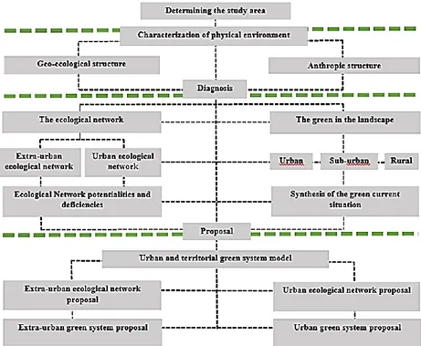
The planning proposal was applied in the Strategic Plan of Green Areas of the city of Pinar del Río and its territory, carried out in 2010 in the Municipal Direction of Physical Planning of Pinar del Río, in Cuba. It was structured in four stages: determination of the study area, characterization of the physical environment,diagnosis of the current situation and proposal, as shown in Figure No. 1.
Página | 782
Figure No 1. Methodological structure for the green system
Source: Castillo, González LG. (2011) Doctoral dissertation: Agriculture, Green System and Sustainability. The city of Pinar del Río and its territory. University of Mediterranean Studies of Reggio Calabria, Italy.
Stage 1: Determination of the study area
In this first stage, the scope and objectives of the study in general must be determined, identifying the regional framework and delimiting the area to be evaluated in the urban and extra-urban areas. The delimitation of the area to be considered in the evaluation must be done, taking into account, mainly, the structure of the hydrographic basin (s), as a physical space delimited by nature itself and particularly by the limits imposed by the zones of runoff from surface waters (falls due to precipitation) and converging towards the same channel.
Stage 2: Characterization of the physical environment
The study aims at knowing the characteristics of the environment and assessing the natural resources based on the traditional approach that is usually carried out on this subject, referred to the knowledge of the geo-ecological structure and the anthropic structure of the site. This case, in addition to the urban area, includes the delimited extra-urban area, where the analysis, inventory and mapping of the biotic and abiotic elements must be carried out.
In the geo-ecological structure the elements of climate, geology, geomorphology, soils, hydrography and landscape are evaluated, the latter being through the traditional method of landscape evaluation from the physical-geographical point of view, conceived as the so-called natural territorial
Página | 783
complexes (CTN), which are no more than the territorial system composed of components and complexes of lower rank that allow to determine the functioning of natural ecosystems.
For the anthropic structure, the elements of the use and tenure of the general soil, the system of population settlements and the productive structure of agriculture are evaluated in the way that is commonly carried out by the related entities.
Stage 3: Diagnosis of urban, peri-urban and extra-urban green
The diagnosis is based on the analysis of the green system in the urban, peri-urban and rural landscape of the entire study area, as well as the ecological network, introducing the most contemporary concepts of landscape and those of landscape ecology. The diagnosis of this green system in the urban landscape, evaluates the elements of urban land use and the structure of the city, as well as the state of that system, its relations with the water surface, urban agriculture, social services, transportation infrastructure, and free spaces, which are inventoried in detail from the catalog of free spaces. From the identification of the different landscape units, which characterize particular sectors of the peripheries of the cities, the predominant pressure factors and their main characteristics are identified.
In the case of the diagnosis in the rural landscape, the extra urban land use inventory is carried out, identifying the character of the landscape, as the expression of the identity of the site. For the ecological network, the main elements of the analysis commonly carried out by landscape ecology are examined. This is based on the identification of the ecosystems present in the study area, as a way for the evaluation of the territorial ecological system and the urban ecological system, from which its potentialities and criticalities must be determined, as well as establishing the indications to improve and enhance its operation.
Stage 4: Proposal of the territorial green system
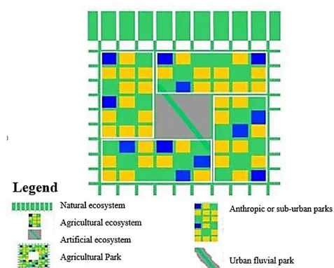
The proposal of the territorial green system should have an ecosystem character and should be built on the rehabilitation of the ecological network of the territorial system, which connects the green areas at all possible scales so that the agriculture recovers its function as an activity that shapes the landscape and diminishes the fragmentation caused by anthropic activity from an ecosystem perspective, as shown in Figure No 2.
Página | 784
Figure No 2. Ecosystem proposal of territorial Green
Source: Castillo, González LG. (2011) Doctoral dissertation: Agriculture, Green System and Sustainability. The city of Pinar del Río and its territory. University of Mediterranean Studies of Reggio Calabria, Italy.
In practice, it is a question of structuring a green system proposal that structurally connects the agricultural ecosystem (formed by the agricultural areas that surround the city) and artificial (the urban area itself) with the natural ecosystem (represented by the areas of greatest naturalness) through the natural biological corridors (rivers and streams) that enable ecological connectivity, relating some spaces with others, also relying on the possibility of using the extensive network of roads and highways, properly wooded. From this perspective, the agricultural ecosystem that surrounds the city will be structured as a large agricultural park, which in turn will be made up of several anthropic parks, shaped by the appreciation of the territorial heritage and local culture.
Página | 785
Figure No 3. Conceptual theoretical model of the territorial green system
Source: Castillo, González LG. (2011) Doctoral dissertation: Agriculture, Green System and Sustainability. The city of Pinar del Río and its territory. University of Mediterranean Studies of Reggio Calabria, Italy.
Within the artificial ecosystem (city) an urban ecological network is structured, articulated from an urban fluvial park that connects to the system of public spaces and the plots of urban agriculture.
CONCLUSIONS
The experience applied to the City of Pinar del Río identified the environmental status of the study area; it territorialized the current situation of the green spaces in the urban, peri-urban and city surroundings establishing a proposal for the green space system in the territory. This was possible from the ecological potentialities and deficiencies that restore the urban, extra-urban and rural ecological network and its concatenation with a system of agricultural, anthropic, urban and peri-urban parks that make possible the creation of a productive and recreational green ring for the city of Pinar del Río. It is connected to the proposals of re-fictionalization of the main public spaces of the city and what will be the main urban river park of this city: the Guamá River Park, which also includes a proposal that provides the insertion of agricultural gardens.From this practice it was evident that:
- Cuban cities, based on the nature of their landscape and their context, need to assess the structural role of agriculture as an option and as a factor in the reconstruction of the territory, in the search for a balance between the city and open spaces; in addition, the obtaining food based on its multifunctional nature;
Página | 786
- The proposal establishes all the elements so that the territory has an instrument that defines and facilitates the work of planning its green system, at the same time it is the driving line for other actions;
-The ordering and management of the system of green areas is also strengthened from a systemic vision of other areas of territorial and urban planning by acquiring a new dimension, including the systemic approach of planning through the elements of landscape ecology, which enables ecosystem relations that includes and considers agriculture as part of the urban and peri-urban green system that elevates the green system from the category of fragments to the system category.
Página | 787
REFERENCES
CASTILLO GONZÁLEZ, L.G. (2010). Strategic plan for the city of Pinar del Río and its territory. Pinar del Río: Municipal Direction of Physical Planning of Pinar del Río. Cuba.
CASTILLO GONZÁLEZ, L.G. (2011). Landscape, agriculture, green system and sustainability. The city of Pinar del Río and its territory. Reggio Calabria Italy: Doctoral dissertation, Faculty of Architecture, University of Mediterranean Studies of Reggio Calabria. Italy.
GURRUTXAGA, M. (2005). Network of Ecological Corridors of the Autonomous Community of Euskadi. Department of the Environment and Territorial Planning. Direction of Biodiversity and Environmental Participation. Vasco government.
IMPERIOM.yVENDITTELLI,M. (2006).Complessitàdelterritorioe progettiambientali,FrancoAngeli,Milano.
MAGNAGHI A. (2005), La rappresentazioneidentitariadel territorio.Atlanti, codici, figure, paradigmiperilprogettolocale, Alinea,Firenze.
NOGUE J. en Franco, Zagari, (2006); Questo è paesaggio: 48 definizione.
Mancoso Editore.
SOCCOC., CAVALIEREA.,GUARINIS.,M. MONTRUCCHIO (2005). La natura dellaCitta. Il Sistema del verde urbano e periurbano. OsservatorioCittaSostenibili, DipartimentoInterateneo Territorio Politecnico e Universita di Torino. FRANCO ANGELI, Milano.
VENDITTELLI, M. (2000). IlPaesaggio da chimera a paradigma, FrancoAngeli,Milano, 2000.
VERDAGUER C., VIANA C., (2000). Peri-urban agriculture as a factor of urban-territorial sustainability. Preliminary conclusions of the case study from the perspective of urban planning. / www.governo.it.es/Cities for a more sustainable future.
ZÚÑIGA L. and PEREZ C. (2013). The resources built of heritage value in an urban environmental management model. Eure Magazine. Vol 39 (not 117, May 2013) pp.69-90.
ZÚÑIGA, IGARZA L. M. (2012). Methodology: Urban environmental management of resources built of heritage value. Application in Gibara, Holguín. Doctoral dissertation, Higher Institute of Technologies and Applied Sciences (InSTEC). Science, Technology and Environment. Cuba.
Página | 788
Recebido: 12 jago. 2018.
Aprovado: 20 set. 2018.
DOI: 10.3895/rbpd.v7n5
Como citar: GONZALEZ, L. G. C.; IGARZA, L. M. Z.; LÓPEZ, I. G.; ROCUBERT, N.C.; VÁSQUEZ,V.C.
Planning of the green system in Cuban human settlements. R. bras. Planej. Desenv., Curitiba, v. 7, n. 5, p. 755-788, Edição Especial Desenvolvimento Sustentável Brasil/Cuba, out.. 2018.Disponível em:
<https://periodicos.utfpr.edu.br/rbpd>. Acesso em: XXX.
Correspondência:
Luis Guillermo Castillo Gonzalez A 4, Pinar del Río, Cuba
Direito autoral: Este artigo está licenciado sob os termos da Licença CreativeCommons-Atribuição 4.0