Edited by
Jaime Aníbal, Ana Gomes, Isabel Mendes & Delminda Moura
RIA FORMOSA
Challenges of a coastal lagoon
in a changing environment
RIA FORMOSA
Challenges of a coastal lagoon
in a changing environment
Edited by
Jaime Aníbal
Ana Gomes
Isabel Mendes
Delminda Moura
Centre for Marine and Environmental Research (CIMA)
University of Algarve, Portugal
Campus de Gambelas, 8005-139, Faro
Title:
RIA FORMOSA. Challenges of a coastal lagoon in a changing environment
Editors:
Jaime Aníbal, Ana Gomes, Isabel Mendes & Delminda Moura
Cover image
Schematic representation of Ria Formosa lagoon (2015)
Credits
Sónia Oliveira (CIMA)
Graphic Design
Grácio Editor
1st Edition: July 2019
ISBN: 978-989-8859-72-3
Depósito legal nº: 455364/19
To cite a chapter of this book:
Name of the author/s (2019). Title of the chapter. In: Aníbal, J., Gomes, A., Mendes, I. & Moura, D. (eds.), Ria Formosa: challenges of a coastal lagoon in a changing environment. 1st edition. University of Algarve. Faro, ISBN 978-989-8859-72-3, pp. pages of the chapter
Persistent identifier: https://sapientia.ualg.pt/handle/10400.1/12475 © Centre for Marine and Environmental Research (CIMA)
University of Algarve, Portugal Campus de Gambelas, 8005-139, Faro
CONTENTS
Acknowledgments ...7
Contributors...7
Foreword...9
Preface...11
Miguel Marques
1. Introduction...13
Delminda Moura, Jaime Aníbal, Isabel Mendes & Ana Gomes
2. Backbarrier shores along the Ria Formosa lagoon...17
A. Rita Carrasco & Ana Matias
3. Role of the Ria Formosa inlets on the physical, chemical
...
and biological exchanges with the adjoining ocean ...29
Alexandra Cravo & José Jacob
4. The role of Ria Formosa as a waste water receiver...47
Filipe Veríssimo, Flávio Martins & João Janeiro
5. Role of microbes in the Ria Formosa lagoon...67
Helena M. Galvão, Pedro J. Mendes, Sandra M. Caetano,
...
John D. Icely & Alice Newton
6. Ecological dynamics of green macroalgae
Ulvales
...
in Ria Formosa: a tale of blooms and shapes ...83
7. Metal contamination in Ria Formosa saltmarsh
...
sediments and halophyte vegetation ...99
Manuela Moreira da Silva, Duarte Duarte & Luís Chícharo
8. Human impact in the Ria Formosa lagoon ...109
Maria João Bebianno, Patrícia Pedro, Ângela Serafim,
...
Belisandra Lopes & Alice Newton
9. Marine energy prototype testing at Ria Formosa...125
André Pacheco, Eduardo Gorbeña & Cláudia Sequeira
10. The application of remote sensing for monitoring the Ria Formosa:
...
the sentinel missions...139
Sónia Cristina, John Icely & Alice Newton
GLOSSARY ...153
ANNEXES...165
Contributors
In addition to the authors of the various chapters, other scientists contributed to this book.
Scientific reviewers
C
láudia Dias SequeiraCentro de Investigação Marinha e Ambiental (CIMA) Instituto Superior de Engenharia
Universidade do Algarve [email protected]
Cristina Maria de Almeida Bernardes
Departamento de Geociências
CESAM - Centro de Estudos do Ambiente e Mar Universidade de Aveiro
Joaquim Manuel Freire Luís
IDL - Instituto Dom Luís Universidade do Algarve [email protected]
Lúcia Maria das Candeias Guilhermino
Instituto de Ciências Biomédicas de Abel Salazar da Universidade do Porto e
CIIMAR - Centro Interdisciplinar de Investigação Marinha e Ambiental
Manuela Falcão
Ex-Instituto Português de Investigação Marítima (IPIMAR)
CRIP Sul-Olhão
Maria Adelaide de Pinho Almeida
Departamento de Biologia e Centro de Estudos do Ambiente e do Mar
CESAM - Centro de Estudos do Ambiente e Mar Universidade de Aveiro
Maria Jacinta da Silva Fernandes
CEPAC - Centro de Estudos em Paisagem, Património e Construção
Faculdade de Ciências e Tecnologia Universidade do Algarve
Miguel José Martins Caetano
IPMA - Instituto Português do Mar e da Atmosfera Division of Oceanography and Marine Environment [email protected]
Paulo Miguel da Costa Zaragoza de Oliveira Pedro
Centro de Investigação Marinha e Ambiental (CIMA) Universidade do Algarve
Acknowledgments
This book results from the research done in CIMA with national funds from FCT-Foundation for
Science and Technology (Portugal) [UID/MAR/00350/2013CIMA].
Foreword
The Centre for Marine and Environmental Research (CIMA) is a multidisciplinary research centre of the University of Algarve. In addition to the scientific research and technological innovation, CIMA is involved in service delivery, graduate training and knowledge transference to the society. The CIMA researchers develop their scientific activity using a multidisciplinary approach, which contributes to produce an integrate knowledge of the ecosystems’ behaviour and to understand the evolution resulting from global changes and anthropogenic impacts. These activities are developed in several territorial foci, of which the Ria Formosa is one of the most intensely studied by the CIMA researchers.
More than 60 titles of scientific papers published so far in journals of international circulation contain the designation of Ria Formosa. Many other dozens of scientific articles are also devoted to the study of the Ria Formosa barrier-island system without including this designation in the title. Dozens of master's and doctoral theses from various national and foreign universities have investigated Ria Formosa's ecology, biology, morphology, hydrodynamics, evolution and socio-economy. Thus, why CIMA decided to publish this book over the Ria Formosa? Precisely because of the intrinsic scientific value of this extraordinary wet zone located in the southern coast of the Algarve, and also several researchers of the CIMA investigate or have investigated the Ria Formosa in its multiple aspects as we can see throughout the chapters of this book.
The scientific dissemination is the main goal of this book. It synthesizes part of the scientific knowledge undertaken by various researchers allowing an integrated view of the Ria Formosa coastal lagoon. The book does not pretend to be exhaustive, as many other works have been carried out. However, we think that readers will find information for an integrated view of the Ria Formosa coastal lagoon. We have tried to convey some of our knowledge, in a simple but scientifically correct language. This compromise is sometimes difficult to achieve. Hence, we have included in each chapter text boxes that explain the less common concepts and also a glossary at the end of the book.
Other scientists named in this book, to whom the editors and authors are grateful, have reviewed the chapters and illustrated some annexes. It is our hope that this book may contribute to the dissemination of the scientific knowledge, which is a common objective of the University of Algarve and the Centre for Marine and Environmental Research (CIMA: http://www.cima.ualg.pt/).
Preface
Miguel Marques
Economist, Specialist in Marine Affairs
This book entitled "RIA FORMOSA. Challenges of a coastal lagoon in a changing environment" is an astonishing exercise of disclosing the main challenges of Ria Formosa, a vital lagoon for the Algarve Region and for Portugal as a whole.
Coastal interface areas between sea and land are very important, rich, sensitive and extremely dynamic areas. There are multiple and complex changes that, either by nature or by human action, occur in coastal zones, from erosion to silting phenomena, from changes in currents to floods ...
This lagoon system, protected by barrier-islands with dunes, is the support of relevant economic
activities. Apparently, these barrier-islands were born in the sea and are in permanent movement, towards the continent. The movement is visible, within a decade, there are areas of sand that are decreasing dangerously and others to gain more sand.
The example of the Ria Formosa reminds us of the need for any planning of activities, industrial or non-industrial, using the coastline should always keep in mind the respect for the environment and should foresee, as far as possible, the physical dynamics that the natural marine resource will have in the future. Failure to take account of the high probability of changes in the coastline, motivated by nature or human beings, means that there may be considerable economic, social and environmental damage that can be avoided.
Congratulations to the authors of this book, that invested their time and deep knowledge to bring to light relevant challenges that Ria Formosa faces and suggestions to overcome the identified risks. The need to implement specific integrated procedures devoted to the management of the back barrier shores. The understanding of the interconnectivity between the lagoon and the sea that does not depend exclusively on tides but also on other driving forces acting on the coast, such as wind and associated oceanographic processes, either inner countercurrent or upwelling. The importance of the use of mathematical
modelling of waste water plumes is a tool that enables the prediction of water quality. The continuous observation of microorganism’s activity enabled by the development of epifluorescence microscopy and sensitive radioisotope techniques is key. The intertidal areas of Ria Formosa are systems with low Ulvales herbivory, meaning that they are not top-down controlled. Phytoremediation on wetlands can be considered an important type of eco-services to society, based on ‘green’ technologies and low energy consumption. The presence of hazardous substances such as metals, persistent organic compounds, and polycyclic aromatic hydrocarbons and emerging contaminants including personal care products and pharmaceutical compounds is a cause of concern for the sustainability of the lagoon. The opportunity to test a floatable tidal energy converter at the lagoon and the application of remote sensing for monitoring the Ria Formosa is shown in this book.
One of the most important lessons I have learned in my many travels around the world to analyse human development across the ocean is that this resource is much less homogeneous than it seems. Each point in the sea is different (in terms of temperature, depth, currents, nutrients ...). In this context, it is
fundamental to study very well all the physical characteristics of the sea in order to be able to develop, in a sustainable way, this fantastic resource. This book is a fundamental contribution to the sustainable development of the oceans, not only because it studies very well the specific characteristics of a place, but also because it analyses in an integrated way the multiple challenges that blue growth has to face in the future.
1. Introduction
Delminda Moura
1, Jaime Aníbal
1, Isabel Mendes
1& Ana Gomes
21
Centre for Marine and Environmental Research (CIMA), University of Algarve, Campus de
Gambelas, 8005-139 Faro, Portugal
2
Interdisciplinary Center for Archaeology and Evolution of Human Behaviour, University of
Algarve, Campus de Gambelas, 8005-139 Faro, Portugal
[email protected]; [email protected]; [email protected]; [email protected]
Ria Formosa is one of the most important weatlands of the Portuguese territory. Its rarity and ecological value led to the creation of the Ria Formosa Natural Park (law-Decree 373/87, 9thDecember). Ria Formosa
hosts a remarkable diversity of habitats and biodiversity. It is of fundamental importance for several species of migratory birds and, some species in decline find here the optimal conditions for nesting. This is the case of the species Porphyrio porphirio that is the symbol of the Ria Formosa Natural Park. Due to protective measures of this species, its population has increased in recent years.
The natural system named Ria Formosa is a shallow coastal lagoon (average depth of 2 m) protected from the direct impact of marine waves by a barrier-island system formed by five islands and two peninsulas facing the sea along ca. 55 km (Figure 1.1). The Ria Formosa barrier islands are narrow and elongated morphosedimentary features that diverge NW and NE orientated from the Cape St. Maria (Figure 1.1). St. Maria de Hárune, later on renamed as St. Maria de Fárão, were the names of the city of Faro, after the Arab domination, during which was Ibne-Hárune (Guerreiro and Magalhães, 1983). The lagoon with extensive marshes and tidal channels (total area of 18000 ha) maintains connections with the sea through six inlets, which guarantees daily renewal of water and nutrients at the pace of tides.
The maintenance of efficient inlets is of fundamental importance for the biodiversity and ecosystem services preservation. Due to the highly dynamic of the hydrosedimentary processes, the inlets tend to migrate eastward drived by the alongshore drift. This was why the Ancão and Fuseta inlets were
relocated. At the east and west ends, the barrier-island system connects with the mainland through two peninsulas (spits), respectively the Cacela and Ancão peninsulas. The remarkable morho-hydrodynamism of the overall system, is also expressed on the landward migration of the backbarrier provoking a
shrinking of the lagoonal area (e.g., Andrade et al., 2004; Ferreira et al., 2016; Kombiadou et al., 2018). Dunes are important forms of the Ria Formosa, which sedimentary dynamic is the main mechanism for the barrier-islands evolution (Ferreira et al., 2016).
One of the great questions about the barrier-islands of the Ria Formosa lagoon, is the origin of such amount of sand necessary to form them. Even today the source of the sands remains open. The fluvial origin of the sediments is discarded since there are no important rivers that flow to the system (Dias et al., 2004; Andrade et al., 2004). However, in the geological past, the rivers and streams, had different shapes and sizes from what we are observing today. Thus, some of the sand of the barrier islands can be inherited from those distant times thereafter reworked by waves and currents. The scarcity of fluvial sediment contribution is one feature that distinguishes the Ria formosa from other coastal lagoon worldwide. In addition, those low fluvial inputs combined with the groundwater discharges into the
lagoon and the high rate of water renewal through the inlets are responsible for the high values of salinity of the lagoonal water (mean salinity = 35.25 g/kg; Newton and Muge, 2003) and for other chemical characteristics of the system (Bebianno, 1995; Andrade et al., 2004; Leote et al., 2008).
Figure 1.1.
Ria Formosa lagoon and barrier island system (Credits: Sónia Oliveira).
Regardless the questions about the source of the sand that forms the barrier islands, the most accepted conceptual model of the genesis of the Ria Formosa, points the mean sea level rise as the main forcer (e.g., Pilkey et al., 1989). During the Last Glacial Maximum (LGM) ca. 18000 years ago, the mean sea level was 120 m lower than the present. Several sandy bodies roughly parallel to the past coastline were formed and migrated landward to form islands, as the mean sea level rose after the LGM. Those islands reached their current position ca. 7000 years ago (Sousa et al., 2014; 2018) (Figure 1.2). Since then, the barrier morphology and evolution were mainly controlled by waves, tides, extreme events (e.g., storms and tsunami) and mean sea level rise.
Barrier islands are among the most vulnerable natural systems to the mean sea level rise, extreme events, and anthropic activities. In this way, a sustainable coastal management is required to mitigate these effects. The Ria Formosa lagoon has been a very attractive area for human occupation, since the
Paleolithic period, due to mild conditions, and living and non-living resources availability. While the first settlements in the 19thand early 20thcenturies were fishermen, since the 1960s the increasing occupation
by buildings and parkings have contributed to the sedimentary imbalance of the barrier island system. This situation is particularly worrisome at the Faro beach, peninsula of Ancão (Ceia et al., 2010).
Beaches, dunes and marshes lead to different habitats therefore to high biodiversity in the Ria Formosa. A high percentage (ca. 90%- Andrade et al., 2004) of the lagoon area is composed by intertidal
morphosedimentary forms (Figure 1.1). According to the elevation of these forms, the environmental variables such as sediment, salinity, thermal amplitudes, insolation and time of submergence are quite different determining a well defined phytozonation (Arnaud-Fasseta et al., 2006; Oliveira, 2014).
Figure 1.2.
Conceptual diagram of the evolution of the Ria Formosa lagoon.
The ecological, morphological, hydrological and socioeconomic values of the Ria Formosa lagoon are dynamically interconnected (see http://www.cima.ualg.pt/cimaualg/index.php/pt/ciencia-para-a-sociedade/aplicacoes-didaticas) and will be further explored along this book.
References
Andrade, C., Freitas, M.C., Moreno, J. & Craveiro, S.C., 2004. Stratigraphical evidence of Late Holocene barrier breaching and extreme storms in lagoonal sediments of Ria Formosa, Algarve, Portugal. Marine Geology, 210 (1-4), 339-362. https://doi.org/10.1016/j.margeo.2004.05.016
Arnaud-Fasseta, G., Bertrand, F., Costa, S. & Davidson, R., 2006. The western lagoon marshes of the Ria Formosa (Southern Portugal): Sediment-vegetation dynamics, long-term to short-term changes and perspective. Continental Shelf Research 26, 363-384. https://doi.org/10.1016/j.csr.2005.12.008
Bebianno, M.J., 1995. Effects of pollutants in the Ria Formosa Lagoon, Portugal. The Science of the Total Environment, 171, 107-115. https://doi.org/10.1016/0048-9697(95)04672-9
Ceia, F.R., Patrício, J., Marques, J.C. & Dias, J.M., 2010. Coastal vulnerability in barrier islands: the high risk áreas of the Ria Formosa (Portugal) system. Ocean & Coastal Management 53, 478-486.
https://doi.org/10.1016/j.ocecoaman.2010.06.004
Dias, A., Ferreira, Ó, & Moura, D., 2004. Livro Guia da Excursão: II Reunião Científica da Rede CYTED-XVII /3º SIPRES, Interdisciolinary Symposium on wetlands, Faro, Maio, 2004, 18p. Available in:
Ferreira, Ó., Matias, A. & Pacheco, A., 2016. The east coast of Algarve: a barrier island dominated coast. Thalassas, 32 (2), 75-85. https://doi.org/10.1007/s41208-016-0010-1
Guerreiro, M.V. & Magalhães, J.R., 1983. Duas Descrições do Algarve no Século XVI. In: Sá da Costa (Edit.), Lisboa, 46 p.
Kombiadou, K., Matias, A., Carrasco, R., Ferreira, Ó., Costas, S., & Vieira, G., 2018. Towards assessing the resilience of complex coastal systems: exemples from Ria Formosa (south Portugal). Journal of Coastal Research, SI 85, 646-650, https://doi.org/10.2112/SI85-130.1
Leote, C., Ibánhez, J.S. & Rocha, C., 2008. Submarine Groundwater Discharge as a nitrogen source to the Ria Formosa studied with seepage meters. Biogeochemistry, 88 (2), 185-194.
https://doi.org/10.1007/s10533-008-9204-9
Newton, A. & Mudge, S.M., 2003. Temperature and salinity regimes in a shallow, mesotidal lagoon, the Ria Formosa, Portugal. Estuarine, Coastal and Shelf Science, 57 (1-2), 75-85.
https://doi.org/10.1016/S0272-7714(02)00332-3
Oliveira, S., 2014. Incorporação de software multimédia e de informação em sistema de informação geográfica: o exemplo da aplicação didática ForDid (Ria Formosa). Trabalho de Projecto do Mestrado em Geomática, Ramo- Análise de Sistemas Ambientais, Universidade do Algarve, 114 p. Available in
https://sapientia.ualg.pt/.../UALG_Sonia_O%20exemplo%20da%20aplicação%20didát...
Pilkey, O.H., Neal, W.J., Monteiro, J.H. & Dias, I.A., 1989. Algarve barrier islands: a noncoastal- plain system in Portugal. Journal of Coastal Research, 5 (2), 239-261.
Sousa, C., Boski, T., Gomes, A., Pereira, L. Lampreia, J. & Oliveira, S., 2014. Holocene reconstruction of the Ria Formosa coastal lagoon (south Portugal) based on a pre-Holocene paleosurface digital model. Comunicações Geológicas 101, Especial I, 635-639.
http://www.lneg.pt/iedt/unidades/16/paginas/26/30/185
Sousa, C., Boski, T. & Pereira, L., 2018. Holocene evolution of a barrier island system, Ria Formosa, South Portugal. The Holocene, 1-3. https://doi.org/10.1177/o959683618804639
2. Backbarrier shores along the Ria Formosa lagoon
A. Rita Carrasco & Ana Matias
Centre for Marine and Environmental Research (CIMA), University of Algarve, Campus de
Gambelas, 8005-139 Faro, Portugal
[email protected]; [email protected]
2.1. Low-energy environments and backbarrier shores: where can we find them?
Low energy beaches are located in sheltered and fetch-limited environments. The fetch, also called the fetch length, is the uninterrupted distance over the sea surface for which the wind can blow without a change in direction and affects the growth of wind-waves. Fetch-limited beaches are found in estuaries and bays (e.g. Chesapeake Bay, USA), behind ocean barriers (e.g. Pamlico Sound, USA), adjacent to inlets (e.g. Tapora Bank, New Zealand), deltas (e.g. Menderes River, Turkey), eroding thermokarst (e.g. Yensei Bay, Russia), and glacial outwash fans (e.g. Canal Baker, Chile; Cooper et al., 2007). In the case of barrier island systems, the back of barrier islands facing the lagoon environments i.e., backbarrier shores are fetch-limited environments. A barrier is an elongated ridge that is composed predominantly of unconsolidated sand and/or gravel and protect the adjacent mainland from open-water processes (Figure 2.1). From the sea to the mainland, the barriers are generally composed of the shoreface, dune and backbarrier environments, and they are separated alongshore by tidal inlets (Figure 2.1). Barrier islands are dynamic systems, constantly on the move, migrating under the influence of waves, tides, currents, storms, and changing mean sea levels. The backbarrier is a narrow, elongated, intertidal landform that is located on the lagoon or estuary side of the barrier island and can take the form of sandy beaches, tidal flats or salt marshes (Figure 2.1). Backbarrier beaches tend to be morphodynamically reflective (according to the classification of Wright & Short, 1984), with steep narrow foreshores that have smaller seasonal variations than open ocean beaches. The tidal flat is bound to the foreshore and might end in a salt marsh fringe. Salt marshes are among the most productive ecosystems on earth. Backbarriers provide critical ecosystem services to coastal populations (see Box 2.1.).Figure 2.1.
2.2. Ria Formosa backbarriers
The Ria Formosa is a highly dynamic multi-inlet barrier island system located in the Algarve region, Southern Portugal (Figure 2.3). The Ria Formosa backbarrier forms a continuum system, ranging from linear sand bodies morphologically indistinguishable from transgressive open-ocean barriers (Pilkey et al., 2009) to extensive fans of tidal marshes, intercepted by very small tidal channels.
The entire Ria Formosa lagoon covers an area of 8.4×10⁷m2(Andrade, 1990), and is characterised by i)
extensive salt marsh areas, with a dense distribution of shallow meanders composed of silt and fine sand (Bettencourt, 1994); ii) large sand flats, partially flooded and reworked during spring tides (Pilkey et al., 1989); and iii) a complex network of natural and partially-dredged channels, which get narrower and shallower towards the upper regions of the system (Andrade et al., 1998). The lagoon is a very shallow area with a maximum depth of 2 m (below mean sea level, Figure 2.3), supporting substantial
sedimentary and morphological variability (Andrade, 1990).
Box 2.1. Backbarrier ecology: the importance of salt marshes
Salt marshes are among the most productive ecosystems on earth and have great ecological value, namely in flood risk management and erosion, nutrient regeneration, primary
production, habitat for wildlife species, and as shoreline stabilizer (e.g. Costanza et al., 1997; Caçador et al., 2016). Salt marshes ecological role have been formally recognised by its inclusion in the Water Framework Directive.
Over time, salt marshes accumulate organic material, forming a dense layer called peat. Salt marshes and tidal flats also play an important role in capturing carbon (especially Zostera noltii tidal plains in Figure 2.2), by absorbing in biomass the gaseous carbon – carbon dioxide. Carbon fixation in the soil is highly beneficial to slow global warming and other harmful effects of high carbon content in the atmosphere. When a marsh is destroyed, usually because of human impact, and the organisms die, the carbon that had been absorbed and stored in the biome will be released back into the air as carbon dioxide.
Figure 2.2.
View of the ecological marsh succession, from the low marsh dominated by Spartina maritima and the tidal flat dominated by Zostera noltii (in the Culatra Island backbarrier; photo by A. Rita Carrasco, 2017).
The barrier system comprises five islands and two peninsulas, separated by six tidal inlets. The barrier system is extremely dynamic which has been related with tidal inlet evolution (Pacheco et al., 2010; Vila-Concejo et al., 2006), shoreline evolution (Garcia et al., 2002), longshore drift (Ciavola et al., 1997),
overwash processes (Matias et al., 2008), dune formation (Gomes et al., 1994), backbarrier processes (Carrasco et al., 2011) and artificial nourishment actions (Dias et al., 2003).
The backbarrier system receives minimal ocean swell and is dependent on local winds for wave
development. Most backbarrier shores face fetch distances shorter than 2 km (see example Figure 2.4A), and therefore they are exposed to small waves and are characterised by low, narrow sandy beaches (Figure 2.4B), alternating with portions of tidal flats, salt marshes, and washover plains (flat areas
generated by large overwash events and breaches). Occasionally, intertidal bars are attached to the beach foreshore (sand banks in Figure 2.4C), suggesting that there is sediment exchange between the low-tide terrace and the foreshore (see beach segmentation in Figure 2.4D).
Evolutionary trends calculated from historic aerial photograph analysis show that the extremities of the system (both peninsulas) are immature (recent and under construction), while the rest of the system is characterised by a predominance of mature backbarriers (Carrasco et al., 2008). The overall evolutionary trend of the Ria Formosa backbarrier indicates a shrinking of the lagoon (coastal squeeze) due to the landward displacement of the backbarrier together with a decrease in the extent of the backbarrier coastline (Carrasco et al., 2008).
From the view point of conservation, the Ria Formosa lagoon was designated a Natural Reserve in 1978, a Natural Park in 1987, and is now part of the Natura 2000 network, with the aim of achieving a rational and sustainable exploitation of its resources (see Box 2.2.). The system hosts high faunal diversity, with
national importance as a nest-building zone and international relevance for bird migration. Moreover, it is considered a worldwide noteworthy wetland area, protected by the RAMSAR and BERNA conventions. Ria Formosa resources protection and exploitation involves a complex web of cultural habits, economic constraints, and legal and political perceptions, amongst other issues, making management a difficult task.
Figure 2.3.
(A) Ria Formosa barrier system (coordinates WGS84; elevation referred mean sea level). (B) View of the two main environments in the backbarrier shores, namely sandy beaches and salt marshes (photos by A. Rita Carrasco, 2017).
Figure 2.4.
(A) Example of fetch distribution behind Praia de Faro;
(B) view of the foreshore (dune and beach face, photos by A. Rita Carrasco, 2008); (C) view of an intertidal bar attached to the tidal flat (sand bank);
(D) example of a typical profile segmentation in sandy backshores at Ancão Peninsula backbarrier composed of dune, beach-face, tidal flat and sand bank.
2.3. Morphological Evolution
Backbarrier beach profile characteristics include a narrow foreshore (~35 m wide, slope ≅ 0.07), with reflective swash zones and a low gradient terrace acting as a wave energy filter (Figure 2.4 (B) and (C)). The tidal flat has a gentle slope (slope ≅ 0.01; Figure 2.4 (C) and (D)), ending in a small flat parallel sand bank (30 m of length, slope ≅ 0.06). The tidal flat is mainly sandy (mean grain size, dmean = 0.3 mm) with 9 % of mud. The beach face and sand bank are coarser (dmean of 0.9 mm and 0.4 mm, respectively).
Site-specific factors related to geomorphologic settings and hydrodynamics, for example the proximity to a tidal inlet, shape beach evolution. Backbarrier beaches face almost the same forcing mechanisms as
Box 2.2. The importance of the Ria Formosa backbarrier and lagoon
to the local economy
Besides being an important element of the overall coastal system, the backbarrier and lagoon serve as the main ‘feeder’ of the local marine economy, with economic activities such as aquaculture, fishing, shipping, sand mining and tourism, coexisting in a fragile and often-competing combination. The shellfish and clams harvest, which takes place in most of the backbarrier shores and inside the lagoon, is the most important addition to the local economy as they are a high-value crop, representing more than 90% of the national clam harvest. It is estimated that about 5000 people depend on the clam industry, out of the about 100,000 people total population around the lagoon (Cristina et al., 2006). Urban development in the Ria Formosa backbarrier is concentrated in 5 villages, namely Praia de Faro, Farol, Hangares, Culatra e Armona (Figure 2.5).
Figure 2.5.
Example human development and activities on the backbarrier of Culatra Island (photo by A. Rita Carrasco, 2006).
oceanic beaches, but at a relatively lower magnitude (Figure 2.6). For instance, wind and wave-setup are much reduced in backbarrier beaches, when compared with wind and wave-setup acting on oceanic beaches; wave-runup is almost null in backbarrier beaches (Figure 2.6).
Figure 2.6.
Comparison between forcing mechanism action in oceanic beaches and backbarrier beaches.
Medium time-scale analysis (days to years) demonstrates that volumetric beach response is slow and continuous (less than tens of cubic meters of change between months), similar to other sheltered mesotidal beaches described in literature (Carrasco et al., 2012; Figure 2.7A and B). Short-term dataset analysis (minutes to days) confirmed the limited sediment transport, with daily rates of change below 0.05 m3/m, occurring mostly on the beach face (see example Figure 2.7B). The beach face and the
nearshore (sand bank) act as independent morphological sub-systems. Contrary to most oceanic beaches, backbarrier beaches lack cyclic changes, with a slow response to hydrodynamic forcing (Figure 2.8).
Figure 2.7.
(A) Volumetric variations at the backshore, beach face, tidal flat and sand bank zones, over two years of analysis in a backbarrier portion of Ancão Peninsula (datasets from BERNA project, financed by Fundação para Ciência e Tecnologia under reference
POCTI/CTA/45431/2002); (B) sand accumulation in the backshore driven by wind, and embryonic berm formation as result of wind-induced waves (associated to relative higher energetic conditions or storm conditions; photos by A. Rita Carrasco, June 2006 and February 2008, respectively).
2.3.1. Wind, waves and tidal currents on the backbarrier beaches of Ria Formosa
Since most backbarriers of the Ria Formosa are nearby- or under the direct influence of tidal channels and inlets, the tidal currents are the principal source of energy for sediments mobilization and transport (Carrasco et al., 2011). Average local tidal currents are within the order of 0.3 m/s, with maximumvelocities of 0.5 m/s; these values are closely dependent on the distance to inlets. Backbarrier beaches are not very reactive to wind intensity fluctuations and the sand availability is an important factor for beach modulation. Figure 2.8 shows the lack of correlation between beach morphological changes and wind variability (Figure 2.8; Carrasco et al., 2012). During relatively high-energy events (e.g. winter), mudflats can even prevent most waves from reaching the barriers and reduce the energy of the few waves that reach the shore (as suggested by Lewis et al., 2007); other factors as wakes present minor influence to
morphology (see Box 2.3.). Wakes are small waves generated by the passage of boats on channels.
Figure 2.8.
Example of beach volume variations at a backbarrier beach exposed to N-NE winds, in comparison with changes in the local wind patterns (wind direction and wind intensity); dashed line represents the averaged beach volume during three years of analysis.
Box 2.3. Do you know that…
The generation, propagation, attenuation and forces related to boat generated wake waves are being recently investigated due to increasing concerns regarding their impact on backbarriers beaches and salt marshes. Boat wakes have been shown to have erosive effects on shorelines (e.g. Ellis et al., 2002), scour the bottom of the shoreface, and temporarily decrease of water clarity (Kurennoy et al., 2011). In addition, boat wake impacts include
vegetative damage and disruption of faunal communities. They are most destructive in shallow and narrow waterways because wake energy does not have the opportunity to dissipate over distance. Numerous waves within these ranges were documented in the Praia de Faro backbarrier and all around the lagoon, especially inside the main navigational channels.
2.3.2. The role of human interventions on the backbarrier shores
Permanent or seasonal human modifications, such as urban development or marine exploitation, are conspicuous on many backbarrier shores in the world (Nordstrom et al., 1996). Many human-altered beaches around the world bear little resemblance to their potential state under natural conditions, and many others were created where none would occur naturally. There are numerous types of impacts, and several have profound effects for many years, for instance, natural sediment deposits in backbarrier marshes, tidal creeks or other lagoon environments, behind barrier islands and spits, have been used in the past for beach nourishment. Dredging operations have removed sediments inside the lagoons, with consequences to the sediment supply of backbarrier shores. This occurred during the last years in the Ancão Peninsula backbarrier, where a dramatic morphological change is noticeable between 1947 and ~2007 (Figure 2.9). The main reasons for the observed changes are artificial operations to manage the Ancão Channel. The dredging of Ancão Channel after 1976 and the relocation of Ancão Inlet in 1996, lead to a shoreline advance (i.e. backbarrier shoreline displacement towards the lagoon), development of a detached morphology (sand bank, Figure 2.9), while the channel reduced its width and its margins enlarged (development of a tidal flat). Human activities left a strong local imprint and consequent inheritance, instilling morphological changes that were neither erased nor counteracted by the cumulative backbarrier evolution trends (Figure 2.9).
2.3.3. The role of sea-level rise in the sedimentary processes of backbarriers
Although the overall understanding of how barrier islands respond to climate change continues to improve, very few details are known about how the backbarrier shores will evolve to rising sea levels (Carrasco et al., 2016), including the behaviour of Ria Formosa under sea-level rise. Literature predicts that under such conditions, backbarrier shores will lose sub-areal extent and the sea-level rise will gradually change the hypsometry of the barrier, transforming supratidal areas into intertidal and open-water environments. Inside the lagoons, the inundation of the tidal flats and salt marshes will probably increase, leading to the conversion of sub-areal areas on backbarrier to open waters (Carrasco et al., 2016).Backbarriers composed of salt marshes, appear to be less vulnerable to rising sea level because marsh can
Figure 2.9.
Aerial views of long-term evolution of the Ancão Peninsula backbarrier (aerial photos from CIMA/UAlg database). Inside the red square, from 1947 to 2007, a sandy platform developed, that differentiated trough time into three sandy morphologies: foreshore, tidal flat and sand bank.
accommodate vertical accretion up to a certain rate (Carrasco et al., 2016; see Box 2.4.), although results are not conclusive.
On the frontier with ocean, sea-level rise may cause changes in inlets geometry or in tidal forcings (Smith, 2001), affecting the baseline level of sediment transport arising to backbarrier shores. It is still, however, difficult to make accurate predictions of coastal change due the non-linearity of sedimentary processes, and the uncertainty on their ‘downscaling’. Even if detailed descriptions exist of the responses of barrier chains and inlets to sea-level rise, as well as various attempts to systematize the foreseen impacts, a deficiency remains in the conceptualization of expected morphological changes.
Box 2.4. The role of seagrass in the long-term sedimentary
processes of backbarrier salt marshes
Seagrass meadows (see Figure 2.10) can stabilise sediments and help to facilitate surface elevation accretion (Fonseca, 1996). When seagrass occupies the entire water column, current velocities are reduced, and sediments tend to accumulate.
The impact of seagrasses is remarkably strong, with average sediment accumulation differences up to 30 mm per year between seagrass and unvegetated areas (e.g. Potouroglou et al., 2017). The capacity of seagrasses for balancing the deposition of
suspended sediment and resuspension is highly dependent on the development stage and health of the plants, as well as local hydrological conditions.
Figure 2.10.
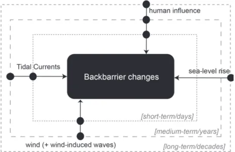
Figure 2.11 summarizes the main drivers and respective timescales of interaction, acting on the backbarrier shores of Ria Formosa. Tidal currents, wind and wind-induced waves, rising sea level and human interventions, are the main natural and anthropogenic forcing mechanisms that drive changes at backbarrier shores (Figure 2.11). Each driving factor operates at different timescales; for instance, human interventions affects the short- to long-term evolution of backbarrier shores, whilst the tidal currents, but at the long-term their effect can be counteracted.
2.4. Coastal management and ecosystem-based approach
Although the Ria Formosa lagoon is protected under the designation of a Natural Park, so far there are no policies devoted specifically to manage its backbarrier shores. Backbarriers are of local great ecological importance (see Box 2.1), and their management requires integrated coastal studies and management strategies linking not only biodiversity and conservation, but also natural evolution and human usage. Because the exploitation of the Ria Formosa backbarrier and lagoon resources have a relevant
contribution to the local economy (see Box 2.2), scientific improvements should look up to the balance between the coastal morphological dynamics and the ecological functions that are hosted by these environments, in an attempt to maintain ecosystem services.
Based on the tendencies highlighted on the previous sections, we propose a simple ecosystem-based management scheme settled in a two-pillar structure, that includes (1) the morphology (type and evolution), and (2) the function (number of functions; e.g. ecological, economic, recreation, amongst others). In Figure 2.12, backbarrier functioning is defined by a flux of sediment (and energy) from the morphology type to the function/service provided. This flux is controlled by internal processes, as small-to long-term behaviours that regulates the morphology type and evolution, and by the environmental characteristics that determines its functioning or provided service (Figure 2.12). External controls account with human interventions that governs the morphological evolutions, and direct uses linked to the provided service. This scheme considers the existence of a dynamic equilibrium crossing the morphology and the function/service, controlled by internal and external processes (Figure 2.12). The scheme
illustrates what we consider the most important factors affecting the management of backbarrier shores. It traduces the idea that despite the lower variability of backbarrier shores, and the uncertainty about its future evolution under external environmental changes (as sea-level rise), and equilibrium between backbarrier morphology and related functions is needed to ensure the ecosystem future maintenance.
Figure 2.11.
Summary of the main drivers and respective timescales acting on the backbarrier shores of Ria Formosa.
Figure 2.12.
Ecosystem-based scheme for the backbarrier shores along the Ria Formosa lagoon.
Acknowledgements
This is a contribution for the EVREST project (PTDC/MAR-EST/1031/2014). A. R. Carrasco was supported by the grant SFRH/BPD/88485/2012.
References
Andrade, C., Cunha, J. M. & Paulino, J., 1998. Geochemical signature of extreme marine flooding in the Boca do Rio lowland (Algarve, Portugal). Proceedings of V Congresso Nacional de Geologia. IGN, SGP, Lisboa, p. C-51/C-54.
Carrasco, A. R., Ferreira, O., Davidson, M. A., Matias, A. & Dias, J. A., 2008. An evolutionary categorisation model for backbarrier environments. Marine Geology 251:156-166.
Carrasco, A. R., Ferreira, Ó., Matias, A. & Freire, P., 2012. Natural and human-induced coastal dynamics at a back-barrier beach. Geomorphology 159-160:30-36.
Carrasco, A. R., Ferreira, Ó., Matias, A., Pacheco, A. & Freire, P., 2011. Short-term sediment transport at a backbarrier beach. Journal of Coastal Research 27:1076-1084.
Carrasco, A. R., Ferreira, Ó. & Roelvink, D., 2016. Coastal lagoons and rising sea level: A review. Earth-Science Reviews 154:356-368.
Ciavola, P., Taborda, R., Ferreira, Ó. & Dias, J. A., 1997. Field measurements of longshore sand transport and control processes on a steep meso-tidal beach in Portugal. Journal of Coastal Research 13:1119-1129.
Cooper, J.A.G., Pilkey, O. H.& Lewis, D. A., 2007. Islands behind islands: an unappreciated coastal landform category. Journal of Coastal Research SI50:907-911.
Dias, J. A., Ferreira, Ó., Matias, A., Vila-Concejo, A. & Sá-Pires, C., 2003. Evaluation of soft protection techniques in barrier islands by monitoring programs: case studies from Ria Formosa (Algarve-Portugal). Journal of Coastal Research SI35:117-131.
Ellis, J. Y., Sherman, D. J., Bauer, B. O. & Hart, J., 2002. Assessing the impact of an organic restoration structure on boat wake energy, Journal of Coastal Research SI36:256-265.
Garcia, T., Ferreira, Ó., Matias, A. & Dias, J. A., 2002. Recent Evolution of Culatra Island (Algarve – Portugal), In: EUROCOAST (Ed.), Littoral 2002, The Changing Coast. EUCC-Porto - Portugal, pp. 289-294.
Kurennoy, D., Parnell, K. E. & Soomere, T., 2011. Fast-ferry generated waves in Southwest Tallinn Bay. Journal of Coastal Research SI64:165-169.
Lewis, D. A., Cooper, J. A .G., Pilkey, O. H. & Short, A. D., 2007. Fetch-limited barrier islands of Spencer Gulf, South Australia, Journal of Coastal Research SI50:912-916.
Matias, A., Ferreira, Ó., Vila-Concejo, A., Garcia, T. & Dias, J. A., 2008. Classification of washover dynamics in barrier islands. Geomorphology 97:655-674.
Nordstrom, K. F., Jackson, N. L., Allen, J. R. & Sherman, D. J., 1996. Wave and current processes and beach changes on a microtidal lagoonal beach at Fire Island, New York, USA In K.F. Nordstrom and C.T. Roman (eds.) Estuarine Shores. London: John Wiley & Sons, Ldt. pp. 213-232.
Pacheco, A., Ferreira, Ó., Williams, J. J., Garel, E., Vila-Concejo, A. & Dias, J. A., 2010. Hydrodynamics and equilibrium of a multiple-inlet system. Marine Geology 274:32-42.
Pilkey, O. H., Cooper, J. A. G. & Lewis, D. A., 2009. Global distribution and geomorphology of fetch-limited barrier islands. Journal of Coastal Research 25:819-837.
Potouroglou, M., Bull, J. C., Krauss, K. W., Kennedy, H. A., Fusi, M., Daffonchio, D., Mangora, M. M., Githaiga, M. N., Diele, K. & Huxham, M., 2017. Measuring the role of seagrasses in regulating sediment surface elevation. Scientific Reports 7:11917.
Smith, N. P., 2001. Seasonal-scale transport patterns in a multi-inlet coastal lagoon. Estuarine Coastal and Shelf Science 52:15-28.
Vila-Concejo, A., Matias, A., Pacheco, A., Ferreira, Ó. & Dias, J. A., 2006. Quantification of inlet-hazards in barrier island systems. An example from the Ria Formosa (Portugal). Continental Shelf Research 26:1045-1060.
Wright, L. & Short, A., 1984. Morphodynamic variability of surf zones and beaches: a synthesis. Marine Geolgy 56:93-118.
3. Role of the Ria Formosa inlets on the physical,
chemical and biological exchanges with the
adjoining ocean
Alexandra Cravo
1,2& José Jacob
1,21
Centre for Marine and Environmental Research (CIMA), University of Algarve, Campus de
Gambelas, 8005-139 Faro
2
Faculty of Sciences and Technology, University of Algarve, Campus de Gambelas, 8005-139
Faro, Portugal
[email protected]; [email protected]
3.1 What is this Chapter about?
A coastal lagoon is a “shallow coastal water body separated from the ocean by a barrier, connected at least intermittently to the ocean by one or more restricted inlets” (Kjerfve, 1994). Coastal lagoons are typically found along low-lying coastlines, affected by a tidal range < 4 m and generally
< 5 m deep (Bird, 1994; Kjerfve,1994).
Coastal lagoons are important ecosystems because these support a wide range of natural services, highly valuable for society. These complex systems provide food, storm protection, tourism, among others. So, they contribute to the overall productivity of coastal waters by sustaining a variety of habitats, including salt marshes, seagrasses, and/or mangroves particularly important for many fish and shellfish species. Water quantity and quality in a lagoon is influenced by the rate at which the lagoon loses or gains water from exchange with the ocean, surface runoff, evaporation, precipitation and groundwater (Allen et al., 1981). Lagoon–ocean exchange is mainly driven by tides, responsible for the lagoon water balance (see Box 3.1.).
Box 3.1. Do you know what tides
are?
The tide is a periodic movement of rising and falling of the water resulting from the
combination of gravitational attraction forces exerted by the moon and sun on the rotating Earth and the centrifugal forces generated in the Earth's rotation around the centre of mass of the system Earth-Moon-Sun. In addition to the gravitational and centrifugal forces, when we want to study and understand the tide we must consider two additional forces, the Coriolis force which is an inertial force due to the Earth's rotation about its own axis, and the frictional force due to the movement of the water with respect to its boundaries.
The magnitude of tidal inputs and patterns of circulation/hydrodynamics are key physical properties that control the residence time of water and associated compounds (see Box 3.2.). Inner areas of the lagoons usually have low flushing rates because of restricted exchange with the ocean. However, close to the inlets the water renewal is promoted, depending on the size and shape of the lagoon, the level of connectivity with
Box 3.2. Did you know what
residence time is?
Residence time is the time a particle spends in a reservoir. Residence time is defined as the amount of water in a reservoir divided by either the rate of addition of water to the reservoir or the rate of loss from it. The various reservoirs in the water cycle have different water residence times. The oceans have a water residence time of 3000 to 3230 years; this long residence time reflects the large amount of water in the
oceans. In the atmosphere the residence time of water vapour relative to total evaporation is only about 10 days. Lakes, rivers, coastal lagoons, ice, and groundwaters have residence times lying between these two extremes and are highly variable. In the case of a coastal lagoon such as Ria Formosa, the residence time is determined by tidal exchange and is
commonly defined as the tidally-averaged time that a Lagrangian particle remains entrained within it.
the ocean, tidal range, and freshwater flow.
Coastal lagoons and coastal oceans are closely interconnected ecosystems, where the interplaying processes (physical-chemical-biological) with the ocean are pivotal for the ecosystem functioning. There, water characteristics are not controlled just by tidal cycles and other relevant processes like upwelling (see Box 3.3.), but also remineralisation in water column, benthic-pelagic interaction, land runoff and point wastewater discharges must be considered acting as driving mechanisms in the coastal waters. The availability of nutrients, relative high residence time and light penetration in shallow lagoons lead to a high rate of primary productivity (phytoplankton and aquatic plants) in water column specially between Spring and Autumn seasons (Barbosa, 2010). This leads to an increase of rates of primary production and supports high rates of secondary production compared to other aquatic ecosystems (Nixon, 1995). For the systems where tidal influence is relevant, this play a key role on renewal and circulation of the water in the lagoon contributing to avoid eutrophication processes.
Those processes and driving mechanisms should be understood to gain insights into how present and future changes will affect the behaviour of coastal lagoons, which ultimately affect the society. Regardless the advances on observational programs focused on processes occurring in coastal lagoons, a large gap
Box 3.3. Do you know what is coastal upwelling and why is it
important?
Coastal upwelling is an oceanographic phenomenon that involves wind-driven motion of dense, cooler, deeper and usually nutrient-rich water towards the ocean surface (Figure below), in response to winds blowing parallel to the coast, more frequent towards the
equator, replacing the warmer, usually nutrient-depleted surface water. This process induces a surface current and a water mass transport – Ekman transport - respectively at 450and 900to
the right of the wind in the North Hemisphere (left in the South Hemisphere). The offshore directed movement of surface waters leads to the lowering of the sea level along the coast. The nutrient-rich upwelled water stimulates the growth and reproduction of primary
producers such as phytoplankton. Due to the biomass of phytoplankton and presence of cool water in these regions, upwelling zones can be identified by cool sea surface temperatures (SST) and high concentrations of chlorophyll a.
Conceptual explanation of coastal upwelling in the northern hemisphere (source:
http://www.seos-project.eu/modules/oceancurrents/ocea ncurrents-c04-s01-p01.html; accessed 23 October 2018).
Box 3.4 - Do you know what mass
exchanges /transport mean?
Systems can exchange a physical property between them across a boundary. When a system such as Ria Formosa exchanges water mass with the adjacent ocean through an open boundary such as one of the tidal inlets, this exchange can be quantified through a quantity called mass transport whose units in the International System are kg/s. Dividing the mass transport by the density of the water we obtain the volume transport, with units in m3/s. In confined flows such
as in rivers, channels or tidal inlets the volume transport can be called discharge. Moreover, in a water flow if we know the concentration of a given dissolved compound and
suspended particles in the water we can calculate the mass transport of these compounds by the flow.
still exists to quantify exchanges, interactions and dynamics between these environments and adjoining ocean. Coupling
multidisciplinary data acquired from observations and remote sensing is fundamental to better understand the functioning of these ecosystems.
In the Ria Formosa, the most important coastal lagoon in the south of Portugal, like in other similar systems, the water and
Box 3.6. Do you know the importance of spring and neap tides?
Spring tides are semidiurnal tides of increased range, which occur approximately twice a month, near the time of new and full moon, when the moon is in syzygy (when the moon, earth and sun are in line). Neap tides are tides of small range occurring between spring tides, near the time of the first and last lunar quarters, when the moon is in quadrature. The fortnightly modulation in semidiurnal tidal amplitudes is due to the various combinations of lunar and solar semidiurnal tides. At spring tides the lunar and solar forces combine together, but at neap tides the lunar and solar forces are out of phase and tend to cancel. In practice the observed spring and neap tides lag the maximum and minimum of the tidal forces, usually by one or two days. In tidal inlets connecting coastal lagoons to the sea and estuaries spring tides have associated stronger tidal currents and neap tides have
associated weaker tidal currents. mass exchanges/transport (see Box 3.4.) derive primarily from interaction with the ocean, through the tidal influence, and channel morphology inside the Ria. The geomorphological characteristics of the Ria Formosa, are presented in section 3.2. Information about the tidal signal and tidal prims (see Box 3.5.) at the main inlets and their influence and contribution for the water circulation of the western sector is described in section 3.3, at spring and neap tidal conditions (see Box 3.6.). The sampling strategy to understand the
hydrodynamics and characterise the water quality at the main inlets are reported in section 3.4. The main patterns of variability at the three inlets of the western sector, on high and low
water, for nutrients and chlorophyll a (a proxy of the phytoplankton growth) during the Autumn season in 2011 under a spring tidal cycle (when the variability is maximum) is shown in section 3.5. The role of lagoon-seawater exchanges through the main inlet of Ria Formosa, the Faro-Olhão inlet, on nutrients, chlorophyll and suspended solids in Autumn 2012, at neap and spring tides, as well as the effect of upwelling on it and consequence upon phytoplankton development, in this shallow system, where nutrients and light are easily available is addressed in section 3.6. The final section 3.7 emphasises those dynamic features that makes the Ria Formosa a peculiar, productive system and one of the most
important lagoons in Portugal. Here, is presented for the first time the exchanges through the three inlets of the western sector, promoted in a specific temporal “window”, in 2012, under upwelling during the Spring season. This corresponds to a period when the phytoplankton development generally increases and during spring tidal conditions when the exchanges are maximum.
Box 3.5. What does tidal signal and
tidal prism mean?
In a record of a seawater property such as the sea level, the tidal signal corresponds to the variability due to the various tidal harmonics. The tidal prism of an estuary or lagoon is the volume of water between the surface levels of high tide and low tide. We can distinguish between the flood prism, the volume of water flowing from the ocean into the estuary or lagoon over the flood period of a semi-diurnal tide, and the ebb prism, the volume of water flowing out of the estuary or lagoon, into the ocean, over the ebb period of a semi-diurnal tide. The difference between the flood and ebb tidal prisms of a semi-diurnal tidal cycle is the residual tidal prism or net transport of water.
3.2. Geographic context and morphology of the Ria Formosa Lagoon
The Ria Formosa is a shallow coastal lagoon system, with a triangular shape, of about 100 km2, 55 km long,
with 6 km of maximum width and an average depth less than 2 m, located in the south coast of Portugal (Fig. 3.1). It is a mesotidal system with a mean tidal range of approximately 2 m, varying from 1.5 m to 3.5 m. Ria Formosa is dominated by the semi-diurnal component of the tide and has six permanent
connections to the ocean (Ancão, Faro-Olhão, Armona, Fuseta, Tavira and Cacela), which provide a great water renewal. These six inlets delimit three hydrodynamically distinct sectors: the eastern sector that includes Cacela; the central sector that includes Fuseta and Tavira inlets; and the western sector that is the most important one in terms of water circulation, encompassing Ancão, Faro-Olhão and Armona inlets. The Ria Formosa is well-mixed vertically due to reduced freshwater inputs and predominance of the tidal forcing in the water circulation inside it (Cravo et al., 2014).
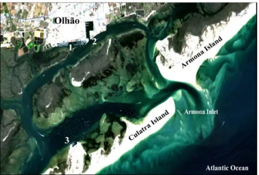
The western sector of Ria Formosa represents approximately 90% of the total tidal prism of the entire lagoon (Pacheco et al., 2010). This sector includes three inlets (Fig. 3.1), the Ancão inlet at the western flank of the barrier system, the Faro-Olhão and Armona inlets at the eastern flank of this sector and several channels and creeks. The two main channels of this sector are the Faro channel connecting the Faro-Olhão inlet to the city of Faro and the Faro-Olhão channel connecting the same inlet to the city of Faro-Olhão.
Figure 3.1.
Ria Formosa lagoon location and its western sector with the three main inlets (Ancão, Faro-Olhão and Armona) and the two main channels, Faro and Olhão. Isobathymetric lines of 50, 100 and 200 m deep are also indicated.
The Ancão inlet is a small inlet with a cyclic eastward migration behaviour. The last cycle began after its artificial relocation on 23 June 1997 in a location 3500 m west of its closing position (Vila-Concejo et al., 2003). During this cycle, storm events breached the barrier updrift (2005) and downdrift (2010 and 2015) of the Ancão inlet position, opening a new inlet that competed with the older one for dominance of the tidal prism (Popesso et al., 2016). While in 2005 the new inlet remained open for only three weeks and then closed naturally, in 2010 the new inlet captured a greater volume of the tidal prism and forced the older inlet to close (Popesso et al., 2016). Finally, the new opening of 2015 was still active in November 2015 while the oldest had already closed. The cycle ended in 29 November 2015 with a new relocation of the inlet to a position close to 1997. The relocation was necessary to improve water exchange in the western part of Ria Formosa because in its migration towards the closing position, the Ancão inlet loses hydraulic efficiency, resulting in a decrease of tidal prism.
Faro-Olhão inlet was artificially opened and stabilised with jetties in the period 1929-1955. A
consequence of these processes was the capture by this inlet of a large tidal prism from the Armona inlet (Ferreira et al., 2016).
Armona inlet is the only naturally stable inlet of the system (Pilkey et al., 1989). It was the dominant natural inlet in the system, but the evolution of the Faro-Olhão inlet greatly reduced the flow through the Armona inlet resulting in a shift in tidal prism dominance from Armona to Faro-Olhão (Pacheco et al., 2011). Moreover, Armona inlet has been narrowing with time (Pacheco et al., 2010; Fabião et al., 2016) and still now there is no evidence that it stopped.
3.3. Tidal influence on the water circulation of the western sector- spring vs. neap
tidal conditions
The total tidal prisms for the three inlets of the western sector of Ria Formosa in Autumn of 2011 and Spring of 2012 are compared with those previously obtained in campaigns carried out between 2004 and 2007 by Pacheco et al. (2010), considered as a reference for this study (Fig. 3.2). The total tidal prism of the western sector of Ria Formosa is of the order of 108m3in spring tides and decrease to values around 6 x 10⁷ m3in
neap tides. The total tidal prism remains relatively stable over time in spring tides, with oscillations that can be related to the range of the specific tides considered. However, this estimate shows a temporal increase in neap tides, particularly evident in flood conditions. The lowest tidal prisms were estimated in Ancão inlet, in the order of 2-8x10⁶m3, followed by Armona and Faro-Olhão inlets, in the order of 107m3(Fig. 3.2).
From these results is was estimated that Ancão inlet contribution is less than 6% of the total tidal prism in spring and neap tide conditions in both seasons (Jacob et al., 2013; Jacob & Cravo, 2016). Faro-Olhão inlet contributes from 59% to 71% and Armona inlet from 25% to 37%, in neap and spring tide, respectively. These results are in accordance with the previous calculations conducted by Pacheco et al. (2010) some years before. Following the evolution of the relative tidal prisms, the Ancão inlet lost tidal prism in spring tidal conditions to Armona inlet during flood and to both Faro-Olhão and Armona inlets during ebb (Jacob & Cravo, 2016). In neap tidal conditions the tidal prism remained stable in Ancão inlet both during flood and ebb, increased during flood and decreased slightly during ebb in Armona inlet, and increased in Faro-Olhão during flood and ebb.
Figure 3.2.
Absolute tidal prisms at the cross sections of the inlets of the western sector of Ria Formosa, An – Ancão inlet, FO – Faro-Olhão inlet and Ar – Armona inlet: results from 2004-2007, considered as reference values from Pacheco et al. (2010) (white bars) in comparison with COALA field experiments, Autumn 2011 (grey bars) and Spring 2012 (black bars).
Box 3.7. Do you know what
measures an ADCP?
Acoustic current meters utilize the Doppler Effect which is the change in frequency of sound reflected by a moving object to measure the velocity of the currents in moving fluids (Fig. 3.3a). The Acoustic Doppler Current Profiler (ADCP) is an acoustic current meters that emits a beam of sound of known frequency that is reflected in small particles moving with the water. The beam reflected back to the receiver will have a change in frequency proportional to the speed of the particles and thus the current speed. One sound beam will give the component of current in the direction of the beam. However, three orthogonal components are needed to get the true current vector so an ADCP utilizes more than one beam. Four beams are typically used to obtain a redundant velocity measurement for data checking and improved instrument reliability. ADCPs measure water speed at multiple water depths or 'range cells' along the path of the acoustic beams.
It is also important to mention that the studied cross-sectional area at Faro-Olhão inlet was much higher than those at the other two inlets of the western sector. During spring tides, when the tidal range is maximum, the sectional area for Faro-Olhão inlet had about 6000 to 6150 m2, in comparison with 3000 to
3300 m2at Armona inlet and 360 to 480 m2at Ancão inlet.
The water exchanges between the main inlets of the western sector of Ria Formosa lagoon and the adjoining ocean play a key role on the productivity of both zones also depending on the
interconnectivity between them through the main channels as presented in the sections 3.4 and 3.5.
3.4. Sampling strategy to understand the hydrodynamics and to characterize the
water quality at the main inlets
To understand the dynamics of the nutrients and chlorophyll a and quantify the exchanges through the main inlets of the western sector several field campaigns along complete tidal cycles were conducted in the last 10 years. The velocity of the currents in the selected sections of the three inlets were measured through an Acoustic Doppler Current Profiler (see Box 3.7.) (Fig. 3.3a), model ADP Sontek, 1500 kHz, bottom track boat mounted (Fig. 3.3b). To quantify the exchanges through the main inlets it was assumed that:
mass transport = concentration of (chemical and biological) parameters × discharge
and discharge represents the water volume transport
water volume transport =velocity normal component × area of the cross section
Figure 3.3.
a) Illustration of a boat-mounted acoustic Doppler current profiler (ADCP) measuring discharge using the moving-boat technique. Source: Mueller et al. (2013); b) Exemplification of the ADCP with bottom tracking; side-mounted on the boat used, synchronized with a global positioning system (GPS Garmin GPSMAP 78S) (Photo by J. Jacob, November 2011).
To determine the nutrients, chlorophyll a and suspended solids concentrations, water samples were collected along the water column (surface, mid water and bottom) using 5 L Niskin Bottles
(Fig. 3.4, (see Box 3.8.). Simultaneously, a water characterisation was conducted in situ at the same levels of depth along the water column, by using a multiparametric probe (Fig. 3.5) that measures
simultaneously temperature, salinity, pH and dissolved oxygen with only one device, through specific sensors.
Figure 3.4.
Equipment and use of Niskin Bottle to collect water samples (Photo by J. Jacob, October 2012).
Box 3.8. Do you know what a
Niskin Bottle is?
A Niskin Bottle is a polyvinylchloride (PVC) sampling bottle with water tight closures at top and bottom, used to collect seawater samples for discrete chemical and biological
measurements. It is equipped with a
subsampling spigot and an air vent and can be triggered at pre-determined depths to collect samples. The PVC material is an unreactive substance, to minimize possible contamination of highly sensitive measurements.
Figure 3.5.
Multiparametric probe used to measure in situ: temperature, salinity, pH and dissolved oxygen (in concentration and in
percentage of saturation) (Photograph by J. Jacob, December 2011).
Afterwards on the laboratory, the water samples were processed, filtered and kept frozen until further analysis using specific analytical methods (Fig. 3.6).
Figure 3.6.
Laboratorial processing of samples (filtration, Photo by J. Jacob, December 2011) (left) and subsequent analytical procedures to determination of nutrients and chlorophyll a concentration (centre and right; Photos by C. Correia, January 2012).
3.5. Variability of nutrients and chlorophyll a in spring tidal conditions of Autumn
2011 through the main inlets of the western sector of Ria Formosa
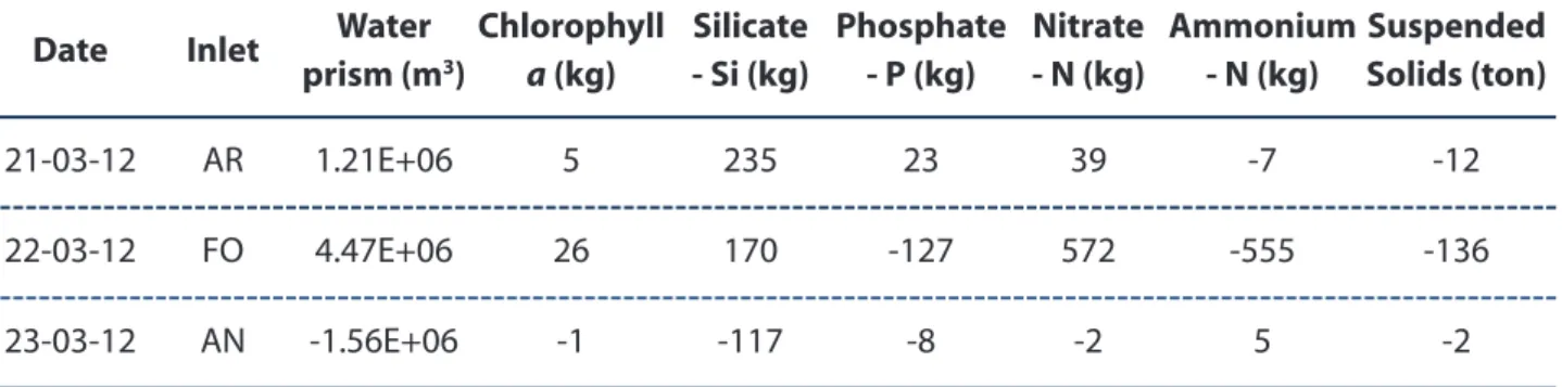
In the last years, several tidal cycles field experiments have been conducted quasi-synoptically at the three inlets on the western sector of Ria Formosa, in the periods of increased phytoplankton activity, i.e. in Spring and Autumn seasons. Here, we present below data for the tidal peaks - low and higher water, on nutrients (Fig. 3.7a) and chlorophyll a (Fig. 3.7b) for the Autumn campaigns of 2011 conducted under a spring tidal cycle, when the differences of water characteristics along the cycle are more evident.
Observations of the water quality at low- and high-water during tidal periods of contrasting ranges allow to assess the importance of exchanges between the lagoon and the ocean. The conditions at those periods may be particularly different in Ria Formosa, since the water volume exchanged is large, in the order of 107m3in each tidal cycle, as shown in Fig. 3.2 of section 3.3.
The nutrients and chlorophyll a concentration (Fig. 3.7), together with measurements taken in situ (temperature, salinity, pH and dissolved oxygen; not shown) along the water column of the three inlets showed no significant differences (p>0.05), confirming that the water column is well mixed.
The range of values at the three inlets was similar, with the smallest variability at Faro-Olhão inlet and the highest concentrations at Ancão inlet. The values measured at high tide were relatively uniform and low, while the differences among inlets were more evident at low water of the spring tide. The differences between at high and low water, is illustrative of the dilution effect caused by the incoming of ocean water during the flood period, usually poorer in nutrients than the lagoon water. In each tidal cycle, the highest values obtained at low water reflect clearly the effect of benthic-pelagic processes, as referred in other studies developed in this lagoon (Falcão and Vale, 2003; Newton et al., 2005; Cravo et al., 2013, 2014). The maximum nutrients concentration observed at Ancão inlet, the smallest and shallowest inlet of the western sector, particularly for nitrate and silicate could be associated with a more intense effect of
sediment diffusion and remineralisation. Phosphate at low water is similar between the three inlets, maybe due to its peculiar behaviour, with strong affinity to be adsorbed to the sediments (Falcão and Vale, 1998).
Figure 3.7.
Mean concentration and standard deviation of: a) nitrate-NO3, phosphate-PO4, silicate-SiO4 and b) chlorophyll a-Chl a, at high and low water in a spring semidiurnal tidal cycle (22-24 November 2011) at Ancão inlet, Faro-Olhão inlet and Armona inlet.
Chlorophyll a was relatively low (< 1 μg/l) and for these tidal conditions the variability among inlets was higher than for the nutrients indicating a less uniform distribution inside the lagoon. The higher mean