IOP Conference Series: Earth and Environmental Science
PAPER • OPEN ACCESS
Urban Design Project Focused On River Sports
To cite this article: Ana Virtudes et al 2019 IOP Conf. Ser.: Earth Environ. Sci. 221 012155
Content from this work may be used under the terms of theCreative Commons Attribution 3.0 licence. Any further distribution of this work must maintain attribution to the author(s) and the title of the work, journal citation and DOI.
Published under licence by IOP Publishing Ltd
World Multidisciplinary Earth Sciences Symposium (WMESS 2018) IOP Conf. Series: Earth and Environmental Science 221 (2019) 012155
IOP Publishing doi:10.1088/1755-1315/221/1/012155
1
Urban Design Project Focused On River Sports
Ana Virtudes1, Gerda Palaityte2, Monika Liaudnskaite2, Dominyka Svarauskaite2,
Ana Carrico3
1 CIAUD, Research Centre for Architecture, Urbanism and Design, University of Lisbon, Portugal.
2 Gediminas Technical University, Vilnius, Lithuania 3 Municipality of São Pedro do Sul, Portugal
Abstract. Touristic activities are growing all-over the world. The number of people traveling
abroad to visit places and having adventures is increasing. Even though the most popular cities and countries in touristic terms are the most visited places, the small cities in rural areas are also defining strategies in order to improve their performances in tourism. The Portuguese city of São Pedro do Sul, very well-known because of its thermal baths with roots in the Roman times, is not an exception on this domain. This is a high potential area for touristic purposes linking the consolidated urban fabric of the city with the river Vouga banks. Therefore, it has all required features to become a touristic spot focused on river sport activities. In this sense this paper aims to present an urban design project having has pivotal goal to promote the sport activities related with the river. This solution was the result of an international team background (Portugal, Slovakia, Brazil, Greece, Poland and Lithuania) with their different understandings about the sensitive areas such as the river banks in an urban context. The conclusions show that the historical buildings can have a new life and use, which was the case of the nineteen-century train station transformed into a multicultural centre. The proposal main strategy is the creation of a set of facilities and public spaces such as the camping or a nautical centre in order to promote the touristic activities related with the river.
1. Introduction
The urban design project that is going to be presented along to this article consists of analysing and creating a new recreational area for people near to the Vouga river in the central region of Portugal. The case study area in a part of the urban fabric of the town of São Pedro do Sul, which is very-well known by its relaxation places and thermal water areas. It refers to the nineteen-century train station building surroundings. Nowadays the train is not coming to this town anymore and part of the train track line was converted into an eco-path for bicycles and pedestrians. The urban design solution was developed in the Unit of Urban Planning of the year four of the Master Degree in Architecture at the University of Beira Interior in Covilhã, Portugal. It was the result of an agreement with the local authority which has required to this university team an urban design proposal focused on the river sport activities such as kayaking. São Pedro do Sul is a small city with a huge presence of natural elements, greenery and low density in terms of the urban fabric and inhabitants. The touristic activities play an important role at the economy of the city based on the visitors of the thermal baths good for skin problems among others. In this sense, the water as an object of the territory is dominating the urban project in functional and beauty perspectives. Therefore, the urban design solution aims to give more importance to the river, which
World Multidisciplinary Earth Sciences Symposium (WMESS 2018) IOP Conf. Series: Earth and Environmental Science 221 (2019) 012155
IOP Publishing doi:10.1088/1755-1315/221/1/012155
could become the main goal for the working team of students. All attentions and functions of the case study area were held regarding the Vouga river bank. Therefore, the case study area was divided in three parts, in order to create different activities which were planned to be the following: sleeping, eating and water sport activities places. All these areas are going to be connected with the main project elements which are the proposed bridges over the river. This proposed set of several bridges aims to become a pivotal element and landmark in the future landscape and simultaneously a place to keep canoes safe, which are pivotal elements of the sport activities.
2. Features of the case study area in São Pedro do Sul 2.1 Environmental analysis
Firstly, in methodological terms there was the need of making an environmental analysis on a small scale of study in order to understand more about the features of the place, considering all surrounding area. Therefore, some axes were designed, related with natural elements and urban fabric characteristics. The area was organized in two main sides, the urban part (on the city side of the river) and the nature part (on the opposite side of the river). In both sides exist some elements which have a crucial importance for the project development. An existent factory, the nineteen-century train station building and the Vouga river are those main elements. Nowadays is possible to notice that all these dots or landmarks are not connected with each other. Therefore, one of the main goals of the urban design solution is to promote a better communication system in between all urban elements. The existing eco-path for pedestrians and bicycles is a good example of an element that links to the river water front and that connects the surroundings (Figure 1, Figure 2, Figure 3 and Figure 4).
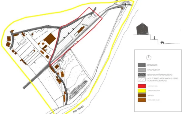
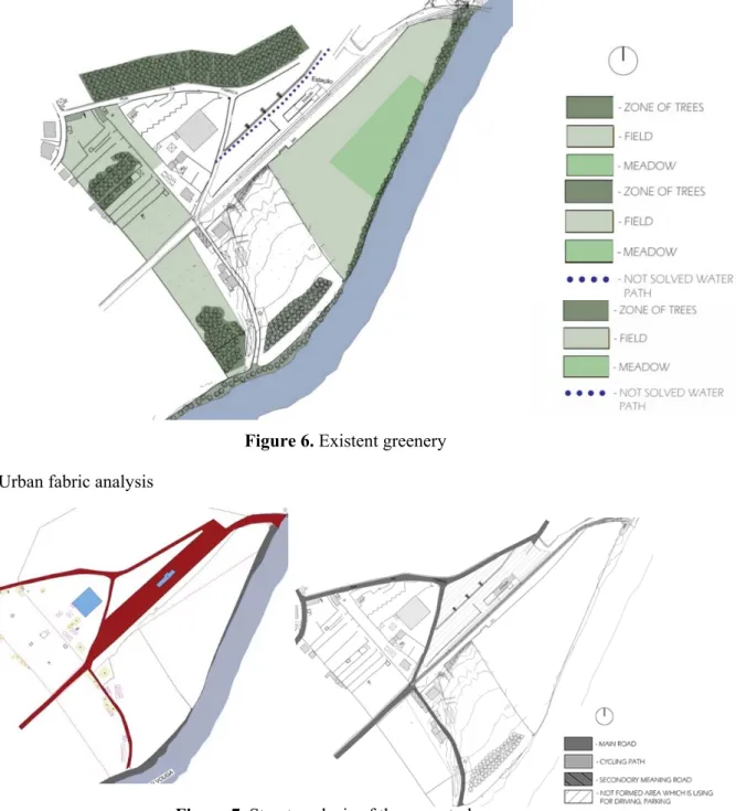
Figure 1. Localization of the case study area: Train station surroundings in São Pedro do Sul, Portugal The case study area limits were defined in order to give an answer to the Municipality expectations for the train station surroundings. The rules of the Municipal Master Plan of São Pedro do Sul has to be followed by the students in their projects [1]. It comprises a central area near to the train station (in red on the Figure 5) and the surroundings until the Vouga river (in yellow on the Figure 5). The greenery is a really strong feature of this place, which is a pleasant space for inhabitants and visitors, giving a sense of closeness with nature (Figure 6). However, there are no planned green areas such as gardens or parks.
World Multidisciplinary Earth Sciences Symposium (WMESS 2018) IOP Conf. Series: Earth and Environmental Science 221 (2019) 012155
IOP Publishing doi:10.1088/1755-1315/221/1/012155
3
Figure 2. Case study area in São Pedro do Sul
World Multidisciplinary Earth Sciences Symposium (WMESS 2018) IOP Conf. Series: Earth and Environmental Science 221 (2019) 012155
IOP Publishing doi:10.1088/1755-1315/221/1/012155
Figure 4. The city side of the river banks and the nature part on the opposite side of the Vouga bank All green elements (Table 1) in this area were formed naturally such as forest (with a surface of 5152 m2), meadows (with 1811 m2) or agriculture fields (with 27314 m2) part of them are included at the reserve for agriculture purposes where the urbanization process is not allowed [2]. These green areas are not suitable for human recreational purposes and many of them are nowadays abandoned and with no use. Thus, is important to restore them and to make them suitable for human activities, improving the tourism and the local people quality of life.
Figure 5. Limits of the case study area: Train station surroundings in São Pedro do Sul, Portugal Table 1. Surface of the existent greenery.
Green elements Surface (m2)
Fields 27 314
Forest 5152
World Multidisciplinary Earth Sciences Symposium (WMESS 2018) IOP Conf. Series: Earth and Environmental Science 221 (2019) 012155
IOP Publishing doi:10.1088/1755-1315/221/1/012155
5
Figure 6. Existent greenery 2.2 Urban fabric analysis
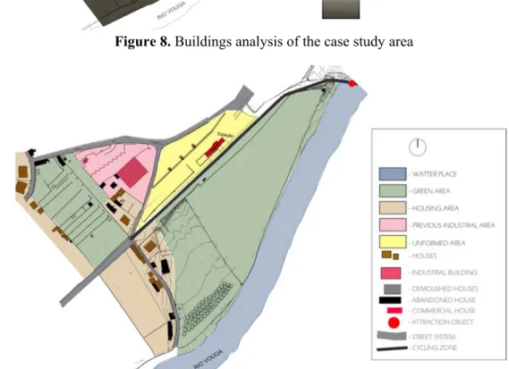
Figure 7. Street analysis of the case study area
Regarding a street analysis of the urban fabric (Figure 7), is possible to notice that there are several problems which need to be solved. A positive aspect is the cycling path which works as an eco-infrastructure with potential for touristic purposes, providing nice river views. However, in this area, there are no formed and suitable paths for pedestrians nor car parking places. This is the first problem, which needs to be solved in terms of public spaces. Some roads like main and secondary streets are nowadays used by local people to reach their homes, however with no proper car lanes nor sidewalks. There is no big variety of activities in this area. The main activity is housing based on the architectonic typology of single-houses. There is only one service activity, which is the cafe in the former train station building. There is as well an abandoned building which was used for industry purposes. Big part of the area is not used at all. So, is important to expand service activities and facilities in order to attract tourism, with no needs of creating more housing buildings. The existent housing is organized in a
low-World Multidisciplinary Earth Sciences Symposium (WMESS 2018) IOP Conf. Series: Earth and Environmental Science 221 (2019) 012155
IOP Publishing doi:10.1088/1755-1315/221/1/012155
density neighbourhood with a maximum of three floors buildings which are the tallest constructions of this area (Figure 8). This means that the character of the landscape is not really effected by built urban fabric. Another thing that is noticed is the different platforms of the terrain used for agriculture fields of grapes plantations on the opposite side of the Vouga river banks. These platforms would be a good feature to be used as a mirror effect for the connection of both sides of the river. Also, these different levels could be used for separating infrastructures from housing to services activities.
Figure 8. Buildings analysis of the case study area
Figure 9. Global map of the existent situation at the case study area
Analysing the Global Map (Figure 9) of the case study area is possible to identify four types of zones which are the following: green area, low density housing neighbourhood, old industrial area and a huge space which does not have usage purposes at the moment. After the analyses of the existing buildings there is the evidence that the majority of them have no value and are not in good conditions (46%). Mostly of them are housing. The biggest space of the area is taken for greenery but it is not organized. In Portugal the Municipal level of the public realm is the main responsible for planning the cities and
World Multidisciplinary Earth Sciences Symposium (WMESS 2018) IOP Conf. Series: Earth and Environmental Science 221 (2019) 012155
IOP Publishing doi:10.1088/1755-1315/221/1/012155
7
designing the urban fabrics, using three figures of spatial planning instruments: Municipal Master Plan, Urban Development Plan and Detailed Local Plan [3] [4].
3. The main ideas of the urban design project.
The main solution of the urban design project is connecting the urban side with the nature side of the case study area, creating spaces for river sports. The core of the area is the old train station which stands according to the project proposal. Given that this town is famous because of its relaxation realm, this project aims to reinforce this aspect creating a huge recreational urban park. Considering another famous aspect of São Pedro do Sul which is the thermal water, the project considers this natural element very important for the urban design solution. The river water front is the most organizing element of this place in territorial terms. Therefore, the main challenge of the solution was the connection of the urban life and nature. In order to achieve this goal, the project proposes long paths for pedestrians symbolizing the nature connection to the busy urban life. Considering the sport activities, the project proposes active kayaks in the river. All the planning solution for the area is based around to this activity and its needs. Usually people who is practicing kayak sports like relaxation contacting with nature, staying there longer than half of day. Thus, the idea came to make three levels of activities based on how active the users want to be, creating the following spaces: zones for kayaking sports, zones for resting, and zones for sleeping, going from a more active to a more passive action (Figure 10 and Figure 11). The first of these levels is the river which is the most active element for kayaking sports. The second place is the zone in between the urban life and the river water front, where there is a relief slightly rising, giving an amazing view of the landscape. Therefore, this place was considered the best one for resting purposes, running away from the busy city life, being called the relaxation zone. The third zone is for greenery (forest), being the calmest place, projected as sleeping zone.
Figure 10. Urban project solution: linking the urban side with the nature side, creating three levels for kayaking sports (active zone, relaxation zone and sleeping zone).
The core of this place is the old train station building. Therefore, the project proposes a restaurant and a place where people can eat, creating a patio where people can spend a good time outside in the summer time, observing the landscape view. The biggest advantage of this place is that people who are
World Multidisciplinary Earth Sciences Symposium (WMESS 2018) IOP Conf. Series: Earth and Environmental Science 221 (2019) 012155
IOP Publishing doi:10.1088/1755-1315/221/1/012155
eating and relaxing can see, at the same time, the beautiful water front panorama in a huge greenery spot. In fact the Portuguese spatial planning system requires a minimum area for greenery in urbanization processes [5]. Some of the other students proposals were precisely focused on the greenery and the ecological development of the area [6], presenting solutions of soft mobility as their main suggestions [7].
Figure 11. Existing situation / Proposal map with the urban design solution for the case study area
World Multidisciplinary Earth Sciences Symposium (WMESS 2018) IOP Conf. Series: Earth and Environmental Science 221 (2019) 012155
IOP Publishing doi:10.1088/1755-1315/221/1/012155
9
At the upper part of the case study area, we can find building which blends together with the terrain relief (Figure 12). This is the place where the information centre and storage are located. Up to the left there is the car parking and behind it starts the housing neighbourhoods. In order to make a pleasant connection in between the car parking and the residential area, the project proposes a green belt of trees. They will help to reduce the noise pollution. The top part of the case study area is for people who comes to spend a longer period of time near to the river. For achieving this goal the project is planning a camping park comprising two sizes of camp fields. There are as well small houses (bungalows) with around 50 m2 each designed for visitors who do not want to stay in the camping park.
Figure 13. Urban design project solution: View of the network of bridges over the Vouga river and for kayaks storage – São Pedro do Sul
World Multidisciplinary Earth Sciences Symposium (WMESS 2018) IOP Conf. Series: Earth and Environmental Science 221 (2019) 012155
IOP Publishing doi:10.1088/1755-1315/221/1/012155
Speaking about the more interesting part of the urban design solution and going down to the river direction, the project considers a network of walking paths, which is also used for the storage of kayaks and as footbridges over the Vouga river, from which visitors can start their kayak journeys. Between the walking paths there is a green zone in which people can spend their leisure time and enjoy the nature with the river view. Different play grounds and small pergolas terraces are also planned for this zone (Figure 13). As a synthesis of the urban design project there is the idea that the proposal takes the biggest part of the case study area for public zones, which takes almost all part of the train station surroundings (Figure 14). The buildings are planned in a low density in terms of construction and the most important task is to create public zones for tourists and locals, focused on the river sport activities. This area was planned to be a leisure time place, with a buildings low intensity, quite green areas and walking paths. 4. Conclusions
As the previous analysis aimed to show, the strongest proposal of this urban design solution was the challenge of connect the Vouga riversides creating a sport area in contact with the nature, able to attract tourists. Regarding the analysis of the case study area, the main existent problems were the following: the unformed green areas, the lack of activities diversity for tourism and local people community or abandoned territory and buildings. Therefore, the most important goal was to connect the urban side with the nature, without doing any harm to it. The proposed set of bridges over the river functioning as well as kayak storages, with an architectonic option based on light wooden constructions is the landmark and the novelty of this project. Finally, the opportunity of analysing a case study area in a real working environment, trying to give answers for the local authority of São Pedro do Sul expectations, considering the strain station surroundings, was an amazing and unique experience for this group of Lithuanian students, attending to the Unit of Urban Planning, on behalf of the ERASMUS exchange programme. Acknowledgments
This publication was supported by the CIAUD, the Research Centre for Architecture, Urbanism and Design, University of Lisbon, financed by FCT, the Portuguese Foundation for Science and Technology. References
[1] Municipal Master Plan of São Pedro do Sul, D.R. no. 237, 13 October 1995.
[2] Law-Regime of the Portuguese National Reserve for Agriculture Purposes, D.L. no. 73/2009, 31 March.
[3] Law-Regime of the Portuguese Spatial Planning System, D.L. no. 380/99, 22 September. [4] Law-Regime of the Portuguese Policy of Land Uses, Spatial Planning and Urbanism, D.L.
no.80/2015, 14 May.
[5] Law-Regime of Portuguese Requirements for Public Spaces Measurements, Portaria no. 218-B/2008.
[6] Virtudes, A., Azevedo, H., Abbara, A., Sá, J. Soft Mobility as a Smart Condition in a Mountain City, 2017 IOP Conference Series: Materials Science and Engineering 245(5),052095
[7] Sá, J., Virtudes, A. Towards Rural Land Use: Challenges for Oversizing Urban Perimeters in Shrinking Towns, 2017, IOP Conference Series: Earth and Environmental Science, 95(5),052016