Brasília-DF: agosto de 2019
Universidade de Brasília Instituto de Ciências Humanas Departamento de Geografia
Programa de Pós-graduação em Geografia
UNIVERSIDADE DE BRASÍLIA
PÓS-GRADUAÇÃO EM GEOGRAFIA
AMAZÔNIA LEGAL: ESTUDO DA RELAÇÃO DO DESMATAMENTO COM A POSSE DA
TERRA NO ESTADO DO MATO GROSSO
Daniella Tiemi Sasaki Okida
Dissertação de Mestrado
Brasília-DF: agosto de 2019
UNIVERSIDADE DE BRASÍLIA
PÓS-GRADUAÇÃO EM GEOGRAFIA
AMAZÔNIA LEGAL: ESTUDO DA RELAÇÃO DO DESMATAMENTO COM A POSSE DA
TERRA NO ESTADO DO MATO GROSSO
Daniella Tiemi Sasaki Okida
Orientador: Osmar Abílio de Carvalho Junior
UNIVERSIDADE DE BRASÍLIA
PÓS-GRADUAÇÃO EM GEOGRAFIA
AMAZÔNIA LEGAL: ESTUDO DA RELAÇÃO DO DESMATAMENTO COM A POSSE DA
TERRA NO ESTADO DO MATO GROSSO
Daniella Tiemi Sasaki Okida
Dissertação de Mestrado submetida ao Departamento de Geografia da Universidade de Brasília,
como parte dos requisitos necessários para a obtenção do Grau de Mestre em Geografia, área de
concentração Gestão Ambiental e Territorial, opção Acadêmica.
Aprovado por:
Osmar Abílio de Carvalho Júnior, Doutor (GEA-UNB)
(Orientador)
Arnaldo Yoso Sakamoto, Doutor (UFMT)
(Examinador externo)
Jeater Waldemar Maciel Correa Santos, Doutor (UFMT)
(Examinador externo)
Ficha catalográfica
É concedida à Universidade de Brasília permissão para reproduzir cópias desta
dissertação e emprestar ou vender tais cópias somente para propósitos acadêmicos
e científicos. O autor reserva outros direitos de publicação e nenhuma parte desta
dissertação de mestrado pode ser reproduzida sem a autorização por escrito do autor.
Daniella Tiemi Sasaki Okida
2. Amazônia Legal
4. Certificação
Programa de Pós-graduação em Geografia –
Dissertação de Mestrado --
Universidade de Brasília, 2019
1. Desmatamento
3. Sistemas Cadastrais
Okida, Daniella Tiemi Sasaki
Amazônia Legal: Estudo Da Relação Do Desmatamento Com A Posse Da Terra No
Estado Do Mato Grosso/ Daniella Tiemi Sasaki Okida; orientador Osmar Abílio de
Carvalho Júnior -- Brasília, 2019.
Agradecimentos
Agradeço ao meu orientador, Dr. Osmar Abílio de Carvalho Júnior, aos professores Dr. Roberto Arnaldo Trancoso Gomes e Dr. Renato Fontes Guimarães, pelo apoio conferido ao longo da dissertação e pela presteza em ajudar e sanar minhas dúvidas no decorrer do tempo. Agradeço também à Dra. Ana Paula Ferreira de Carvalho, pela atenção e solicitude.
Ao João Augusto Martins de Santana, pela paciência e ajuda constantes ao longo do desenvolvimento do trabalho.
À Coordenação de Aperfeiçoamento de Nível Superior (CAPES) pela bolsa concedida durante o curso de mestrado.
Aos colegas de curso pelo compartilhamento de informações. À minha família, pelo constante apoio.
Resumo: Esta pesquisa examina as relações entre a redução das Florestas e a certificação de propriedades no Estado do Mato Grosso. A área de estudo abrange 483.469 km² do bioma Amazônia no estado do Mato Grosso, que é inteiramente contido dentro da Amazônia Legal Brasileira, localizada no “Arco do desmatamento”, onde a agropecuária compete com a cobertura vegetal nativa. O monitoramento e os sistemas cadastrais de certificação de propriedades são algumas das políticas públicas que o Brasil tenta implementar para enfrentar esses desafios ambientais. Nesse contexto, cruzamos os dados do Instituto Nacional de Reforma Agrária (INCRA) com o programa anual de monitoramento do desmatamento (PRODES), do Instituto Nacional de Pesquisas Espaciais (INPE). O sistema cadastral que utilizamos é o Sistema de Gestão Fundiária (SIGEF) que foi lançado em 2013. Realizamos a análise de 2013 a 2017 com propriedades públicas e privadas e avaliamos as dinâmicas no comportamento de desmatamento de pequenos proprietários e grandes proprietários. Os resultados mostram que a certificação da terra causa um impacto maior no desmatamento das pequenas propriedades (menores de 100ha ). O SIGEF é relativamente novo e, portanto, é necessário mais tempo para estabelecer uma tendência de conservação consolidada.
Abstract: This research examines the relations between forest decrease and property legal security in Mato Grosso State. The study area encompasses 483.469 km² of Amazonian biome in the Mato Grosso State, which is entirely contained within the Brazilian Legal Amazon-BLA, located at the “Arc of deforestation” where agriculture and cattle ranching compete with the native vegetation cover. Cadastral monitoring and certification of productive land plots are some of the public policies Brazil tries to implement to tackle these environmental challenges. In this context, we crossed the data from the National Institute for Agrarian Reform (Instituto Nacional de Colonização e Reforma Agrária - INCRA) with the annually deforestation monitoring program (Programa de Monitoramento da Floresta Amazônica por Satélite – PRODES) from Brazilian National Institute of Space Research (Instituto Nacional de Pesquisas Espaciais - INPE). The cadastral system we used is the SIGEF (Land Management System) and was launched in 2013. We performed the analysis from 2013 to 2017 with public and private land plots and evaluated the differences in the deforesting behavior of smallholders and large landowners. The results show that there is a small impact within the predatory behavior when land tenure security is enforced, and small properties are greater impacted in the deforestation rates. The SIGEF system is relatively new and therefore more time is needed to establish a consolidated conservation trend.
Sumário:
CAPÍTULO I – APRESENTAÇÃO GERAL ... 9
1.1. Introdução ... 9
1.2. Revisão metodológica ... 10
1.3. Objetivos ... 11
1.4. Estruturação da dissertação ... 11
CAPÍTULO II – BRAZILIAN LEGAL AMAZON: RELATIONS BETWEEN DEFORESTATION AND LAND TENURE SECURITY IN MATO GROSSO STATE ... 14
Lista de figuras:
Fig 1. Location map of the study area ...18
Fig 2. Mato Grosso Annual Deforestation Rate. (INPE, 2018) ...19
Fig 3. SIGEF Processes (INCRA, 2013). ...20 Fig 4. Variation of Forest Cover Decrease from 2012 to 2017 in the Study Area and in the certified properties (%). ...22 Fig 5. Variation of Forest cover (m²) by year of certification in private and public properties. ...23
Fig 6. Example of Forest Cover evolution from 2013 to 2017 ...23
Fig 7. Forest Cover (%) by size per year after certification. Note: y-axis in logarithmic scale ...25
Lista de tabelas:
Table 1. Summary of the Brazilian Legal Amazon Legislation ...15
Table 2. Properties certified from 2013 to 2017……….21
Lista de abreviaturas:
IBAMA Instituto Brasileiro do Meio Ambiente e dos Recursos Naturais Renováveis
IBGE Instituto Brasileiro de Geografia e Estatística
INCRA Instituto Nacional de Colonização e Reforma Agrária
INPE Instituto Nacional de Pesquisas Espaciais
LANDSAT Land Remote Sensing Satellite
MCTI Ministério da Ciência, Tecnologia e Inovação
MDA Ministério do Desenvolvimento Agrário
MMA Ministério do Meio Ambiente
PRODES
Monitoramento do Desmatamento da Floresta Amazônica Brasileira por Satélite
SIGEF Sistema de Gestão Fundiária
CAPÍTULO I – APRESENTAÇÃO GERAL
1.1.
IntroduçãoO Brasil enfrenta o desafio de equilibrar o avanço da produção agrícola com as áreas de proteção ambiental (GIL et al., 2015). Nesse contexto, a implementação do Novo Código Florestal de 2012, que flexibiliza as regras em comparação com a lei anterior de 1965, representa um grande desafio para a administração nacional (KROGER, 2017). O Brasil se destaca como parte significativa da produção mundial de produtos agrícolas. Uma preocupação para as próximas décadas é a capacidade de suprir demanda do mercado por alimentos combustíveis e energia, levando em consideração a necessidade de expansão agrícola e pecuária sem ameaçar as áreas de proteção ambiental (NEPSTAD et al., 2009).
Em regiões de floresta tropical, o desenvolvimento tradicional segue o modelo de fronteiras, onde as florestas são substituídas por outros tipos de usos, considerados mais relevantes para a produção e para os ganhos econômicos. (BECKER, 2001). Observa-se que a especulação financeira da terra nesses locais é comum e o mercado não depende da presença da titulação formal do imóvel (HOLLAND et al., 2016; CARRERO e FEARNSIDE, 2011; MERRY
et al., 2008).
Wood et al. (2000), em seu estudo, evidencia que a posse de título sobre a terra desestimulava a exploração de madeira e promovia o reflorestamento. L’Roe (2016) demonstra que o registro formal de propriedades levou à diminuição do desmatamento em fazendas de 100ha a 300ha.
Políticas de titulação de propriedades são conceitualmente derivadas de um entendimento mais geral, oriundo das ciências econômicas, conhecido como o “paradigma do direito à propriedade” (ALCHIAN e DEMSETZ, 1973). De acordo com o paradigma do direito à propriedade, o estudo de Wood (2000) entende que a insegurança sobre a posse da terra significa que os fazendeiros não tem certeza se irão colher os benefícios do seu próprio comedimento e investimento. Sob estas circunstâncias, espera-se que os fazendeiros sem título da terra prefiram o consumo imediato dos seus recursos, ao invés de um comportamento de investimento a longo prazo. Assim, acabam minando sua terra e extraindo seus recursos (extrativismo de madeira) ao invés de se dedicarem a estratégias de produção sustentáveis.. Brown (2016) indica que o tipo de ocupação da terra e o desmatamento na Amazônia Brasileira estão correlacionados.
Pacheco (2009) pondera que a reforma agrária pode reduzir as taxas de desmatamento quando o pequeno proprietário recebe terras que, em outras circunstâncias, seria rapidamente degradada por médios e grandes fazendeiros, através de plantações de soja e pastos para pecuária. Em contraste, o efeito da reforma agrária no desmatamento é negativo à medida que induz o assentamento em áreas de baixo interesse/pressão de outros agentes de desmatamento. Assim, para Pacheco (2009), o resultado da reforma agrária no desmatamento depende muito da
configuração socioeconômica e geográfica das fronteiras pré-existentes.
1.2.
Revisão metodológica1.2.1.
Área de estudoA área de estudo é composta por 483.469km², referentes à porção do estado do Mato Grosso com o bioma amazônia, conforme o Mapa de Biomas do Brasil (IBGE, 2017) porque o estudo utilizou como elemento de comparação a classificação Floresta do PRODES. O Mato Grosso é o terceiro maior Estado do Brasil, com 903.198,091km², 141 municípios e corresponde a 10,61% da área total do Brasil (IBGE, 2017).
O Novo Código Florestal (BRASIL, 2012) flexibiliza alguns pontos referentes às áreas de reserva legal. As regras determinam que, em imóveis rurais localizados na Amazônia Legal, a reserva será de 80% da propriedade nas áreas de florestas; 35% nas de cerrado; e 20% para os imóveis em áreas de campos gerais.
O Mato Grosso, estado sensível do “Arco de Desmatamento” onde a agricultura encontra-se em rápida expansão e onde os sistemas de produção pecuária local são muito dependentes da terra, com baixa densidade e por isso contribui com o aumento da pressão sobre a terra e sobre sua mudança de uso (COHN et al., 2014). Considerando que o Mato Grosso é o maior produtor de soja e gado do país e se encontra adjacente à porção mais densa da floresta Amazônica, Fearnside (2003) ressalta que as grandes fazendas possuem mais tendência a desmatar para implementar áreas de pastos do que os pequenos fazendeiros, apesar de haver exceções. As evidências encontradas são de que a maior parte do desmatamento é feito pelos médios e grandes fazendeiros. Fearnside (2002) conclui que o investimento em subsídios e na intensificação da pecuária na Amazônia Brasileira não oferece indícios de que resultaria em diminuição de desmatamento e que fatores como a especulação imobiliária da terra e a segurança da posse da terra poderiam ser mais relevantes nas ações de diminuição do desmatamento.
1.2.2.
SIGEF e PRODESO Sistema de Gestão Fundiária (SIGEF) é uma ferramenta eletrônica desenvolvida pelo Instituto Nacional de Colonização e Reforma Agrária (INCRA) e pelo Ministério do Desenvolvimento Agrário (MDA) para auxiliar na governança fundiária do território nacional. O sistema é responsável pela recepção, validação, organização, regularização e disponibilização das informações georreferenciadas de limites de imóveis rurais, públicos e privados.
O estudo utilizou as informações de 1.065 propriedades públicas certificadas/registradas entre 2014 e 2017 e 13.351 propriedades particulares certificadas/registradas entre 2013 e 2017. A responsabilidade de georreferenciar o imóvel (identificar seus limites e representá-los por meio de coordenadas) é do Profissional Credenciado e a responsabilidade sobre o estabelecimento de direitos reais é do Registro de Imóveis, enquanto a responsabilidade do
INCRA é receber os dados de cada imóvel e certificar que não se sobrepõem e que obedecem ao mesmo padrão técnico.
O projeto PRODES realiza o monitoramento por satélite do desmatamento por corte raso na Amazônia Legal e disponibiliza anualmente as taxas de desmatamento na região. O PRODES utiliza imagens de satélites da classe LANDSAT (20 a 30 metros de resolução espacial e área mínima mapeada de 6,25 hectares). O projeto PRODES conta com a colaboração do Ministério do Meio Ambiente (MMA), do Instituto Brasileiro do Meio Ambiente e dos Recursos Naturais Renováveis (IBAMA) e é subordinado ao Ministério de Ciência, Tecnologia e Inovação (MCTI). Dados do PRODES foram usados em vários estudos nos últimos anos para pesquisas (BROWN, 2016; JUSYS, 2016; MÜLLER et al., 2016).
1.3.
ObjetivosO objetivo deste estudo é analisar a relação entre a certificação da propriedade do banco de dados SIGEF com o desmatamento observado pelo projeto PRODES entre os anos de 2013 a 2017 no bioma amazônia no estado do Mato Grosso.
1.4.
Estruturação da dissertaçãoEsta dissertação foi elaborada no formato de apresentação de artigos científicos segundo as diretrizes estabelecidas para o Programa de Pós-graduação em Geografia da Universidade de Brasília.
No capítulo I foi apresentada uma breve descrição do tema, contendo o problema em questão, o objetivo do trabalho e as fontes de dados utilizadas
No capítulo II será apresentado o artigo intitulado “Brazilian Legal Amazon: relations
between deforestation and land tenure security in Mato Grosso State”.
No capítulo III serão discutidas algumas conclusões e considerações sobre o desenvolvimento do trabalho juntamente de algumas recomendações finais.
Referências
ALCHIAN, A. A.; DEMSETZ, H. The Property Right Paradigm. v. 33, n. 1, p. 16–27, 1973. BECKER, B. Revisao das políticas de ocupaçao da Amazônia: é possível identificar modelos
para projetar cenários? Parcerias Estratégicas, n. 12, p. 135–159, 2001.
BRASIL. Diário da República, 1a série - no 116, n. Pdr 2020, p. 3901–3902, 2012.
BROWN, D. S.; BROWN, J. C.; BROWN, C. Land occupations and deforestation in the Brazilian
Amazon. Land Use Policy, v. 54, p. 331–338, 2016.
CARRERO, G. C.; FEARNSIDE, P. M. Forest clearing dynamics and the expansion of landholdings in Apuí, a deforestation hotspot on Brazil’s Transamazon Highway. Ecology and Society, v. 16, n. 2, 2011.
COHN, A. S. et al. Cattle ranching intensification in Brazil can reduce global greenhouse gas emissions by sparing land from deforestation. Proceedings of the National Academy of Sciences, v. 111, n. 20, p. 7236–7241, 2014.
FEARNSIDE, P. M. Can pasture intensification discourage deforestation in the Amazon and
Pantanal regions of Brazil? Deforestation and Land Use in the Amazon, n. February, p. 283–364,
2002.
FEARNSIDE, P. M. Deforestation Control in Mato Grosso: A New Model for Slowing the Loss of Brazil’s Amazon Forest. Ambio, v. 32, n. 5, p. 343–345, 2003.
GIL, J.; SIEBOLD, M.; BERGER, T. Adoption and development of integrated crop-livestock-forestry systems in Mato Grosso, Brazil. Agriculture, Ecosystems and Environment, v. 199, p. 394–406, 2015.
HOLLAND, T. G.; COOMES, O. T.; ROBINSON, B. E. Evolving frontier land markets and the
opportunity cost of sparing forests in western Amazonia. Land Use Policy, v. 58, p. 456–471,
2016.
IBGE. Brasil em Números [Brazil in figures] - 2017. v. 10, p. 376, 2017.
JUSYS, T. Fundamental causes and spatial heterogeneity of deforestation in Legal Amazon. Applied Geography, v. 75, p. 188–199, 2016.
KRÖGER, M. Inter-sectoral determinants of forest policy: the power of deforesting actors in
post-2012 Brazil. Forest Policy and Economics, v. 77, p. 24–32, 2017.
L’ROE, J. et al. Mapping properties to monitor forests: Landholder response to a large
203, 2016.
MERRY, F.; AMACHER, G.; LIMA, E. Land Values in Frontier Settlements of the Brazilian
Amazon. World Development, v. 36, n. 11, p. 2390–2401, 2008.
MÜLLER, H. et al. Beyond deforestation: Differences in long-term regrowth dynamics across
land use regimes in southern Amazonia. Remote Sensing of Environment, v. 186, p. 652–662,
2016.
NEPSTAD, D. et al. The End of Deforestation in the Brazilian Amazon. Science, v. 326, n. 5958, p. 1350–1351, 2009.
NOLTE, C.; AGRAWAL, A.; BARRETO, P. Setting priorities to avoid deforestation in Amazon protected areas: Are we choosing the right indicators? Environmental Research Letters, v. 8, n. 1, 2013.
PACHECO, P. Agrarian Reform in the Brazilian Amazon: Its Implications for Land Distribution
and Deforestation. World Development, v. 37, n. 8, p. 1337–1347, 2009.
WOOD, C.; WALKER, R. Tenure security, investment decisions and resource use among
CAPÍTULO II – BRAZILIAN LEGAL AMAZON: RELATIONS BETWEEN
DEFORESTATION AND LAND TENURE SECURITY IN MATO GROSSO STATE
Abstract: This research examines the relations between forest decrease and property legal security in Mato Grosso State. The study area encompasses 483.469 km² of Amazonian biome in the Mato Grosso State, which is entirely contained within the Brazilian Legal Amazon-BLA, located at the “Arc of deforestation” where agriculture and cattle ranching compete with the native vegetation cover. Cadastral monitoring and certification of productive land plots are some of the public policies Brazil tries to implement to tackle these environmental challenges. In this context, we crossed the data from the National Institute for Agrarian Reform (Instituto Nacional de Colonização e Reforma Agrária - INCRA) with the annually deforestation monitoring program (Programa de Monitoramento da Floresta Amazônica por Satélite – PRODES) from Brazilian National Institute of Space Research (Instituto Nacional de Pesquisas Espaciais - INPE). The cadastral system we used is the SIGEF (Land Management System) and was launched in 2013. We performed the analysis from 2013 to 2017 with public and private land plots and evaluated the differences in the deforesting behavior of smallholders and large landowners. The results show that there is a small impact within the predatory behavior when land tenure security policies are enforced, and small properties are greater impacted in the deforestation rates. The SIGEF system is relatively new and therefore more time is needed to establish a consolidated conservation trend.
2.1. Introduction
Land tenure rules define how property rights to land should be allocated within societies and are an essential part of social, political, and economic structures (FAO, 2002). According to Demsetz (1967), property rights influence land-use choices and practices; for example, the owner of a private right focuses his acts on future benefits and costs opportunities. On the other hand, public land would tend to suffer from hunting and overwork in a short period because no one would privately own the land. Like the idea “no one washes a rental car” attributed to many authors, landowners treat their properties (in terms of improving soil against erosion) more responsibly than tenant farmers (Sklenicka
et al., 2015). Land ownership is related to welfare (Rao, 2018) and deforestation rates (Brown, 2016;
Nolte et al., 2013). Goldstein et al. (2018) evidence that investments affect increased tenure security in the early stages of formalizing land ownership in Benin, West Africa. In Ethiopia, land security/property rights are the most significant factors in farmers’ decision to invest in reforestation (Legesse et al., 2018).
The definition of Brazilian Legal Amazon was by law in 1953, with 5,020,000 km² (IBGE, 2014) under the legislation of the Superintendence of the Economic Valorization Plan of Amazon (SPVEA) aimed to promote sustainable development of the Amazon region through the integration of the regional economy. In 1966, the government extinguished SPVEA and created the Superintendence of the Amazon Development (SUDAM) of the Regional Development Ministry (Brazil, 1966). Table 1 present a summary of the Brazilian Legal Amazon legislation.
One of the current challenges in Brazilian Legal Amazon is to balance the expanding agricultural frontier with forest preservation (Gil et al., 2015, Arvor et al., 2016). Sant’Anna (2017) shows that deforestation in the Amazon is related to the process of land inequality and land occupation in Brazil. The 2012 revised Brazilian Forest Code established a series of changes concerning the protection of forests and the flexibilization of the ruling over deforesting farmers, including the amnesty for illegal deforestation in private properties before 2008 (Arima et al. 2014, Soares Filho, 2014, Stickler et al., 2013). Besides, the current Forest Code as a governance tool intends to support the agricultural development in already deforested areas while protecting still standing native vegetation through legal reserves (RL), areas of permanent protection (APP), and compulsory rural environmental registry
(CAR) (Arvor et al., 2016; Azevedo et al., 2017, Bircol et al., 2018, Santiago et al., 2018).
Table 1.
Summary of the Brazilian Legal Amazon Legislation
Date Law nº Description
1953, January 6th
1.806
Defines the Economic Valorization Plan of Amazon (SPVEA) and establishes the region considered Brazil’s Legal Amazon. Only part of Mato Grosso state is considered into the Legal Amazon region.
1966, October
27th 5.173
Extinguishes the SPVEA and creates the Superindence of the Amazon Development - SUDAM.
1977, October 11th 31 (Supple mentary Law)
Creates the State of South Mato Grosso by dividing the original area of Mato Grosso into two smaller areas: Mato
Grosso and South Mato Grosso.
Establishes that the new configuration of Mato Grosso is under the regulations of SUDAM and the Legal amazon legislation.
2001,
May 4th 2.146-1 Extinguishes the SUDAM and creates de Amazonian Development Fund. 2001,
August
28th 10.267
Put into effect the Certificate of Rural Property Registry - CCIR. Creates the National Rural Property Registry - CNIR. Reinforces the National Rural Registry System - SNCR. 2006,
July
24th 11.326
Establishes the guidelines for the National Familiar Agricultural Policy. 2007, January 3rd 124 (Supple mentary Law)
Re-establishes the Superindence of the Amazon Development - SUDAM as a financially independent special autarchy, under the National Integration Ministry and part of the Federal Planning and Budget System.
2009, June
25th 11.952
Set the rules for land ownership regularization in the Legal Amazon Territory.
2009, October 28th
6.992
Regulates the law nº 11.952 (June 25th, 2009). Provides the legal mechanisms for land regularization in the Brazilian Legal Amazon where the state of interest - Mato Grosso is located.
2009, Decem ber 29th
12.187 Institutes the National Policy on Climate Change - PNMC.
2012, May
25th 12.651
The Presidency established the current rules for native vegetation protection. This law is also known as the Native Vegetation Protection Law (NVPL).
2017, July 11th
13.465 Institutes mechanisms to enhance the process that enables the disposal of Federal lands. Set the rules for Land Regularization in rural and urban areas.
However, land tenure insecurity problems in Brazil is a challenge for public policies in both urban (Ferreira and Avila, 2018) and rural environments (Duchelle et al., 2014, Araujo et al., 2009, Jepson, 2006), worsening in the Brazilian Legal Amazon because of territorial extension. In this context, the Brazilian National Institute for Colonization and Agrarian Reform (INCRA) and the Ministry for Agrarian Development (MDA) developed a web-based tool named Land Management System (Sistema de
Gestão Fundiária – SIGEF) to subsidize land governance in the national territory. The SIGEF system
manages the information of Brazilian rural properties, receiving, validating, and organizing the data. Therefore, this system controls land regularization processes and provides the georeferenced boundaries of the certified properties (INCRA, 2013). In the Brazilian Legal Amazon, smallholder farmers and large landowners impact differently on land use, and the relationship changes continually with economic and demographic pressures. Large landholders are more sensitive to economic changes (interest rates, financial returns, government subsidies, agricultural credit, inflation rate, and land prices) (Fearnside, 2003). Studies have shown a relationship between land registration with forest preservation in the Brazilian Amazon (Alix-Garcia et al., 2018, L’roe et al., 2016, Araujo et al., 2009). This research aimed to analyze the dynamics of the land regularization system (SIGEF) with the deforestation rate monitored by the Amazon Deforestation Monitoring Project (PRODES) project from 2013 to 2017 within the Amazon biome in the Brazilian State of Mato Grosso. One of the aims of this study is the verification of the influence of certification in the deforesting behavior within the public and private properties.
2.2. Data and methods 2.2.1. Study area
Mato Grosso State has an area of 903,202 km² (IBGE, 2017) and is in the southern Brazilian Legal Amazon within the “Arc of Deforestation”, where occurs the expansion of agriculture and cattle ranching (Stickler et al., 2013, Pacheco, 2012, Fearnside, 2003). The estimated population of the state is of 3.035.122 people with a population density of 3,36 (people per km2), according to the latest
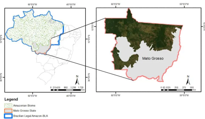
census (IBGE, 2010). This state has 141 municipalities and harbors springs and rivers from three river basins: (1) Upper Paraguay, (2) Araguaia-Tocantins, and (3) Amazon. The Mato Grosso contains three biomes: (1) Amazon, (2) Cerrado (Brazilian Savannah), and (3) Pantanal (Wetlands). The study area corresponds to the Amazon rainforest areas within the Mato Grosso, covering a total area of 483,469 km² (Fig. 1).
Fig. 1. Location map of the study area.
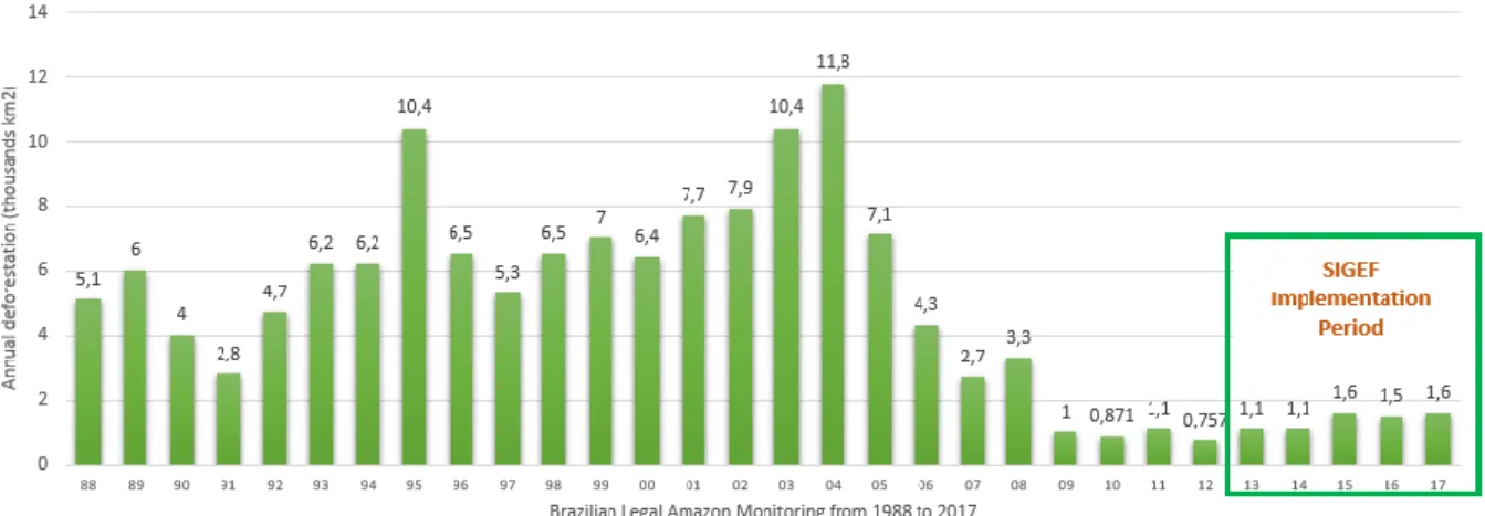
Mato Grosso State has the largest large farms, with over 75% of the agricultural and livestock areas maintained on farms larger than 1,000 ha (Richards and VanWey, 2015). In the period 1998-2017, the Mato Grosso State deforested about 142,967 km² (Fig 2), corresponding to 33.3% of all deforestation in the Brazilian Amazon (PRODES, 2018). The deforestation rates reached a maximum peak in 2004. The launch of the near-real-time deforestation detection system in the Brazilian Amazon (DETER) led to a reduction in rates. Therefore, between 2004 and 2007 occurred a significant deforestation decrease, attributed to the application of public policy enforcement, monitoring systems, and supply chain interventions, slowing down the advance of the agricultural frontier (Nepstad et al., 2014). In 2009 was implemented a program of land regularization in Legal Amazon named Terra Legal Program, coordinated by the Ministry for Agrarian Development and operated by the National Institute for Agrarian Reform (INCRA), whose legal landmark was the establishment of the Law n°11.952/2009.
Cattle ranching, followed by soybean planting, was the main deforestation factor in Mato Grosso (Silva and Lima, 2018, Maranhão et al., 2019). However, the public and private policies have been able to reduce large-scale deforestation in the major soy-and-cattle frontiers of South America (Nolte
efforts to reduce the loss of its primary forest (Arima et al.2014).
Fig. 2. Mato Grosso Annual Deforestation Rate. (INPE, 2018)
2.2.2. SIGEF and PRODES database
The INCRA introduced in 2013 the Land Management System (SIGEF) to process and validate land regularization protocols and publish georeferenced data on a web-based platform (Fig.3). The extinct Ministry for Agrarian Development coordinated the development of the SIGEF project with a partnership with INCRA, which contributed the previously accumulated knowledge to the automated certification (e-Certifica). The SIGEF certifies the properties boundaries (Brazil, 1973) and manages georeferencing contracts within the public administration. SIGEF documents have digital signatures and certificates used in the registry, which configures a further property legal security to the landowner. The rural land certification is an exclusive activity of the INCRA (Brazil, 2001), ensuring the legal and technical requirements of property limits and eliminating overlap. Management through the SIGEF system (Fig. 3) englobes: (i) professional accreditation for rural certification; (ii) digital authentication within the platform; (iii) standardized georeferenced data; (iv) automatized validation of the information in compliance with the technical requirements; (v) automatized generation of technical documents; (vi) electronic management of rural plot of land requirement files; (vii) possibility of online updated information inclusion; (viii) georeferencing services and contract management with the public administration; and (ix) open access to information about certified land plots and accreditation procedures.
Fig. 3. SIGEF Processes (INCRA, 2013).
Since 1988, the Brazilian National Institute of Space Research has provided annual clear-cut deforestation data for every State of the Brazilian Legal Amazon. PRODES data production uses Landsat satellite imagery (30-meter resolution and revisiting each 16 days), measuring increments higher than 6.25 ha, and disregarding forest growth after deforestation (Câmara, 2001).
In the present study, the class named ‘Forest’ by PRODES was used, including the following vegetations: (i) Dense Ombrophilous Forest; (ii) Open Ombrophylous Forest; (iii) Seasonal Deciduous Forest; (iv) Alluvial Vegetation; (v) Campinarana; and (vi) Ecological Tension Areas (forest/savanna) with predominance of Forest Physiognomy (Mines and Energy Ministry, 1978). The high accuracy of PRODES data (Hansen et al., 2013; Valeriano et al., 2012) allows its extensive use in social and natural surveys (Brown, 2016; Jusys, 2016; Müller et al., 2016). Therefore, these data had applications in the following programs: (i) agribusiness supply chain certification, for example the soy moratorium; (ii) international agreements such as the UN Climate Change Conference in Paris (COP21); and (iii) supporting information for financial aid through the Amazon Fund (Brazilian Ministry of Environment, 2016).
2.2.3. Data Processing
This research used the SIGEF data of certified rural plots during the period 2013-2017 of the Mato Grosso State, evaluating the following characteristics: public and private plots, land plot size (<100 ha, 100–250 ha, 250–1,000 ha; 1,000–5,000 ha, and >5,000 ha) (Richards et al., 2015), and certification year within the land regularization system. Besides, the methodology considered the preservation condition of the area: (i) evolution of deforestation in the period 2012-2017; (ii) forest cover rate inside and outside certified public/private plots between 2013 and 2017; and (iii) deforestation by the size of certified parcels in the period 2013-2017. Table 2 shows the evolution of certification in the SIGEF from 2013 to 2017. In the SIGEF system, there is a difference between certification and registration terms. Registered status has fully complied with the Public Registry requirements. However, the certified status already means that the land has been successfully in identification and processing steps, and there is legal property security.
Table 2. Properties certified from 2013 to 2017 in the SIGEF.
The number of public and private properties registered in SIGEF are different, while privately owned land corresponds to 13.351 inputs in the system, public plots correspond to 1.065 properties with 7% of the total (Table 2). The deforestation impact of the public property area is also smaller when compared with the area of private land plots. The total area of certified private properties from 2013 to 2017 is 91.752,15km², and the total area of public lands within the program is 28.235,01km², which corresponds to 23% of the total. Although public units have smaller quantities, they are considerably larger. The number of entirely deforested properties ranged from 18% to 38%, a considerable amount for the Amazon Biome, where the Brazilian Forest Code (2012) establishes a
Legal Reserve of 80% (or maximum of 20% of deforestation permitted per plot).
2.3. Results
2.3.1. Forest cover from 2012 to 2017
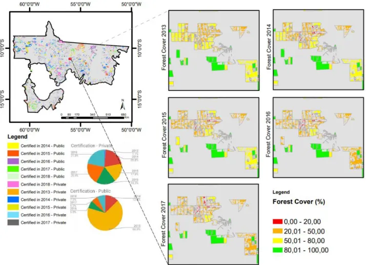
In the period 2012-2017, there was a forest loss of 5963km². In 2017, the forest cover corresponded to 52% of the study area. Figure 4 shows the forest cover decrease detected from 2012 to 2017 in the study area and within the certified properties during the SIGEF implementation process.
Fig. 4. Variation of Forest Cover Decrease from 2012 to 2017 in the Study Area and in the certified properties (%).
2.3.2. Forest cover within and outside the certified properties
Between 2013 and 2017, deforestation was 240,70 km² inside certified public plots and 14771,39 km² inside certified private plots. We observe a consistent and regular deforestation rate through the years in the public plots. In the private plots, there was a slight increase in the deforestation rate from 2014 to 2017. Whilst 2015 had the highest record of deforestation in the study area, deforestation within the public plots found its peak at 2016. In private properties, the highest deforestation record was in 2015, which is consistent with the overall data. In 2015, private plots certified in 2015, 2016 and 2017 presented a deacceleration in the monitored deforestation behavior.(Fig. 5).
Fig. 5. Variation of Forest cover (m²) by year of certification in private and public properties.
We verify that private plots certified in 2015 slowed down the deforestation process after obtaining the certification. Private plots certified in 2013 maintained a stable behavior, while private plots certified in 2014 and 2016 had accelerated deforestation. Certification of public plots only showed a decline in deforestation in 2014. In 2015, public plots that received certification in 2016 slowed deforestation but resumed the increased deforestation rate in the following years. Figure 6 shows the evolution of forest cover degradation from 2013 to 2017 in the study area. Public plots only showed signs of the relation between certification and a decrease in deforestation in 2014.
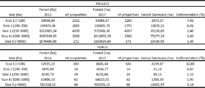
Fig. 6. Example of Forest Cover evolution from 2013 to 2017 2.4.3 Forest cover by property size
Table 3 presents the area deforested in the period 2013-2017 by the size of the rural property. Property size distribution is not homogeneous, especially in public properties, where the smallest properties (<100 ha) corresponds to around 80% of the total. The percentage of deforestation on the
smallest public properties is more than eight times the largest public properties (>5,000 ha). However, the deforested area on the largest properties is five times bigger than the smallest properties in the analyzed period.
Figure 7 shows the variation of forest cover by size and year after the certification. Most properties maintained stable deforestation behavior in the first years after certification. Private property sizes 2, 3, 4, and 5 have accelerated deforestation over the years. Size 1 was the only identified case where certification and decrease in deforestation had a positive relation. In public plots, Size 1 was the only case where we found a sharp decline in deforestation between the first and second years after certification. Figure 8 brings the frequency distribution of Forest cover (from 0% total deforestation to 100% entire forest cover). Most property categories have a peak concentration in forest cover from 0%-10%, which is alarming within the Brazilian Legal Amazon territory. The private and public properties of size 5 behave very differently, with strong indications that most of the large public land plots do not comply with the preservation of native vegetation. Small landowners (private or public) had a higher rate of deforestation over the years analyzed than the large landowners, although the total area deforested be higher in large owners.
Fig. 7. Forest Cover (%) by size per year after certification. Note: y-axis in logarithmic scale.
In 2016 and 2017, there was no difference in the public land plots forest cover observed within the PRODES database for Size 1 farms. The positive relation with the deforestation rate is resumed after 2017.
Figure 8 comprises the frequency distribution of the five different properties sizes in both public and private land plots in 2013 and 2017. We observe that public land plots presented a distinctive behavior from private plots in sizes 1 and 5. Whilst private size 1 and 5 presented preservation of 80% or more since the beginning of the analysis and kept the preservation in compliance with the Forest Cover in some cases, in public plots this amount of almost zero since 2013. We did not find evidence of reforestation over the three years of the study (within the SIGEF implementation timeframe).
2.4. Discussion
Brazil is currently facing several interconnected challenges such as land tenure insecurity, certification through land registration and management systems, misappropriation of public lands, reduction of productive potential, agrarian conflicts, and deforestation (Alix-Garcia et al., 2018; Marra
et al., 2015). Our results suggest that secure land tenure rights through certification in the SIGEF had
an impact factor for controlling forest degradation only in specific cases – related to the size of the property, where small landowners seem to be more susceptible to these public policies. These results agree with McIndewar (2016), who considers that registration in the national land programs contributes to higher territory governance and a reduction of deforestation in Brazil. Studies in the state of Pará developed by L'roe et al. (2016) also confirm that land ownership may be one factor associated with forest degradation behavior. This relationship between ownership and land-use practices occurs even in developed countries. Heide (2019) describes in Austria an increase of this relationship when the rent is insecure or short term, a situation compatible with the Brazilian scenario. The Brazilian Constitution (1988) establishes that "the Union, the states, the Federal District and the municipalities, in common, have the power: VII – to preserve the forests, fauna and flora," which indicates the importance of the forest preservation in the national legal system. Although the rules are clear, our research shows that obedience is a challenge to overcome. The current law has the potential to combat illegal deforestation but faces significant difficulties: economic viability for enforcement and international pressure for food production. Enforcement activities utilize satellite data on the land cover but need improved monitoring systems and regulations to ensure the legal security effectiveness (Nunes et al., 2019; Azevedo et al., 2017; Assunção et al., 2015).
Large public forest areas are susceptible to the failure of federal and state government policies to allocate those areas into social and environmental protection projects because of the difficulties of public supervision and governance enforcement, especially in agriculture and cattle ranching frontiers existent in Mato Grosso State (Azevedo-Ramos and Moutinho, 2018; Schielein and Börner, 2018).
Deforestation behaviors differ according to property size. In the first four years after the implementation of the SIGEF certification, smallholders showed a decrease in the deforestation pace compared to the size of larger properties. Considering that large properties have more area available for restoration than small farms, those findings strengthens the necessity for better initiatives supporting smallholder production (Thaler et al., 2019; Stefanes et al., 2018).
Sparovek (2019) found that 44.2% of Brazilian lands are private, 36.1% are public, and 16.6% are unregistered or with unknown tenure, and there is up to 50% of overlaps among land tenure categories, a cause for concern because SIGEF system methodology does not allow overlaps. The SIGEF timeframe is still recent, and further studies are necessary to establish the parameters for a native vegetation conservation trend.
2.5. Conclusion
This study used a GIS analysis to evaluate the impact of certification of public and private properties with deforestation within the Amazonian biome in Mato Grosso State. We found that private properties certified in 2015 slowed deforestation rate in the subsequent years. Certification of public plots did not give strong signs of influence in the deforestation behavior, where we found a positive relation only in 2014.
Smaller landholders (less than 100ha) represent most of the system (SIGEF) inputs, corresponding, in 2017, to 22,4% of all properties (public and private). Still, their impact on deforestation rates is significantly lower when compared to large landowners that represent only 2,5% of all properties but concentrates 78% of the forest loss in 2017. Size 1 properties, both in public and in private land plots, were the only cases where we found a positive relationship between certification and decrease in the deforestation behavior over the years after the implementation of the SIGEF database.
Land tenure inequality and the still narrow timeframe of the SIGEF database challenged the present research. We were able to identify signs of the relation between certification and deforestation increase when we compared our analysis with the deforestation rates of non-certified/out of SIGEF properties in the Amazonian biome of Mato Grosso.
Acknowledgments
This work benefited from support of the Coordination for the Improvement of Higher Education Personnel (CAPES) and Brazilian National Council for Scientific and Technological Development (CNPq).
References
Alix-Garcia, J., Rausch, L. L., L’Roe, J., Gibbs, H. K., & Munger, J. (2018). Avoided Deforestation Linked to Environmental Registration of Properties in the Brazilian Amazon. Conservation Letters, 11(3), 1–8. https://doi.org/10.1111/conl.12414
Araujo, C., Bonjean, C. A., Combes, J. L., Combes Motel, P., & Reis, E. J. (2009). Property rights and deforestation in the Brazilian Amazon. Ecological Economics, 68(8–9), 2461–2468. https://doi.org/10.1016/j.ecolecon.2008.12.015
Arima, E. Y., Barreto, P., Araújo, E., & Soares-filho, B. (2014). Land Use Policy Public policies can reduce tropical deforestation : Lessons and challenges from Brazil, 41, 465–473.
Arvor, D., Daugeard, M., Tritsch, I., De Mello-Thery, N. A., Thery, H., & Dubreuil, V. (2016). Combining socioeconomic development with environmental governance in the Brazilian Amazon: the Mato Grosso agricultural frontier at a tipping point. Environment, Development and Sustainability, 20(1), 1–22. https://doi.org/10.1007/s10668-016-9889-1
Assuncąo, J., Gandour, C., & Rocha, R. (2015). Deforestation slowdown in the Brazilian Amazon: Prices or policies? Environment and Development Economics, 20(6), 697–722.
https://doi.org/10.1017/S1355770X15000078
Azevedo, Andrea A., Rajão, R., Costa, M. A., Stabile, M. C. C., Macedo, M. N., dos Reis, T. N. P., … Pacheco, R. (2017). Limits of Brazil’s Forest Code as a means to end illegal deforestation.
Proceedings of the National Academy of Sciences, 114(29), 7653–7658.
https://doi.org/10.1073/pnas.1604768114
Azevedo-Ramos, C., & Moutinho, P. (2018). No man’s land in the Brazilian Amazon: Could undesignated public forests slow Amazon deforestation? Land Use Policy, 73(January), 125–127. https://doi.org/10.1016/j.landusepol.2018.01.005
Bircol, G. A. C., Souza, M. P. de, Fontes, A. T., Chiarello, A. G., & Ranieri, V. E. L. (2018). Planning by the rules: A fair chance for the environment in a land-use conflict area. Land Use Policy, 76(April), 103–112. https://doi.org/10.1016/j.landusepol.2018.04.038
Brasil. (1953). Lei n° 1.806, de 6 de janeiro de 1953, 1–3. Brasil (1966). Presidência da República, 1–13.
Brasil (1988). Constitution of the Federative Republic of Brazil.
Retrieved from https://dre.pt/application/file/67508032
Brazilian Ministry of Environment. (2016). Planos de Ação para a Prevenção e o Controle do Desmatamento Documento base : Contexto e análises. Planos Setoriais de Mitigação e
Adaptação, 199. Retrieved from
http://combateaodesmatamento.mma.gov.br/images/conteudo/Planos_ultima_fase.pdf
Brazilian Institute of Geography and Statistics (IBGE). (2010). Census 2010: Characteristics\nof the population and househol. Retrieved from http://www.censo2010.ibge.gov.br/
Brown, D. S., Brown, J. C., & Brown, C. (2016). Land occupations and deforestation in the Brazilian Amazon. Land Use Policy, 54, 331–338. https://doi.org/10.1016/j.landusepol.2016.02.003
Câmara, G., & Monteiro, A. M. V. (2001). Configurações Espaciais do Processo de Desflorestamento da Amazônia. Programa de Ciência e Tecnologia Para Gestão de Ecosistemas Ação "Métodos,
Modelos e Geoinformação Para a Gestão Ambiental”.
Demsetz, H. (1967). Toward a Theory of Property Rights. American Economic Review, 57(2), 347–359. https://doi.org/10.1126/science.151.3712.867-a
Duchelle, A. E., Cromberg, M., Gebara, M. F., Guerra, R., Melo, T., Larson, A., … Sunderlin, W. D. (2014). Linking forest tenure reform, environmental compliance, and incentives: Lessons from redd+ initiatives in the brazilian amazon. World Development, 55, 53–67.
https://doi.org/10.1016/j.worlddev.2013.01.014
FAO - Food and Agriculture Organization. (2002). Land Tenure and Rural Development. FAO land
tenure studies,. https://doi.org/9251048460
Fearnside, P. M. (2003). Deforestation Control in Mato Grosso: A New Model for Slowing the Loss of Brazil’s Amazon Forest. Ambio, 32(5), 343–345. https://doi.org/10.1639/0044-7447(2003)032[0343:DCIMGA]2.0.CO;2
Ferreira, F. P. M., & Ávila, P. C. (2018). Who has secure land tenure in the urban areas of Brazil? Evidence from the state of Minas Gerais. Land Use Policy, 75(April), 494–504. https://doi.org/10.1016/j.landusepol.2018.03.054
Gil, J., Siebold, M., & Berger, T. (2015). Adoption and development of integrated crop-livestock-forestry systems in Mato Grosso, Brazil. Agriculture, Ecosystems and Environment, 199, 394–406. https://doi.org/10.1016/j.agee.2014.10.008
Goldstein, M., Houngbedji, K., Kondylis, F., O’Sullivan, M., & Selod, H. (2018). Formalization without certification? Experimental evidence on property rights and investment. Journal of Development
Economics, 132(January), 57–74. https://doi.org/10.1016/j.jdeveco.2017.12.008
Hansen, M. C. C., Potapov, P. V, Moore, R., Hancher, M., Turubanova, S. A. a, Tyukavina, A., … Townshend, J. R. G. R. G. (2013). High-Resolution Global Maps of. Science, 342(November), 850– 854. https://doi.org/10.1126/science.1244693
Heidi, L., Penker, M., & Salhofer, K. (2019). Do farmers care about rented land? A multi-method study on land tenure and soil conservation. Land Use Policy, 82(August 2018), 228–239. https://doi.org/10.1016/j.landusepol.2018.12.006
IBGE. (2014). Mapa da Amazônia Legal. Diretoria de Geociências - Coordenação de Geografia, 75.
Retrieved from
ftp://geoftp.ibge.gov.br/cartas_e_mapas/mapas_regionais/sociedade_e_economia/amazonia_leg al/amazonia_legal_2014.pdf
IBGE, (2017). Brasil em Números [Brazil in figures] - 2017, 10, 376.
INCRA. (2013). Norma de Execução No 107 de 23 de agosto de 2013, 2013.
Grosso, Brazil. Economic Geography, 82(3), 289–316.
https://doi.org/10.1111/j.1944-8287.2006.tb00312.x
Jusys, T. (2016). Fundamental causes and spatial heterogeneity of deforestation in Legal Amazon.
Applied Geography, 75, 188–199. https://doi.org/10.1016/j.apgeog.2016.08.015
L’Roe, J., Rausch, L., Munger, J., & Gibbs, H. K. (2016). Mapping properties to monitor forests: Landholder response to a large environmental registration program in the Brazilian Amazon. Land
Use Policy, 57, 193–203. https://doi.org/10.1016/j.landusepol.2016.05.029
Legesse, B. A., Jefferson-Moore, K., & Thomas, T. (2018). Impacts of land tenure and property rights on reforestation intervention in Ethiopia. Land Use Policy, 70(April 2017), 494–499. https://doi.org/10.1016/j.landusepol.2017.11.018
Leonhardt, H., Penker, M., & Salhofer, K. (2019). Do farmers care about rented land? A multi-method study on land tenure and soil conservation. Land Use Policy, 82(August 2018), 228–239. https://doi.org/10.1016/j.landusepol.2018.12.006
Maranhão, R. L. A., de Carvalho Júnior, O. A., Hermuche, P. M., Gomes, R. A. T., McManus Pimentel, C. M., & Guimarães, R. F. (2019). The Spatiotemporal Dynamics of Soybean and Cattle Production in Brazil. Sustainability, 11(7), 2150. https://doi.org/10.3390/su11072150
Marra, T., Barbosa, K., & Oliveira, E. (2015). Brazil towards an effective cadastre with sigef thiago marra , kilder barbosa , eduardo oliveira. FIG Working Week 2015, (May 2015), 17–21.
McIndewar, L. (2016). Regularização Fundiária e Efeitos do Programa Terra Legal no Desmatamento, (February 2017), 2–4. https://doi.org/10.13140/RG.2.2.17389.38881
McManus, C., Barcellos, J. O. J., Formenton, B. K., Hermuche, P. M., de Carvalho Jr, O. A., Guimarães, Gianezini, M., Dias, E. A., Lampert, V. N., Zago, D., & Neto, J. B. (2016). Dynamics of cattle production in Brazil. PloS one, 11(1), e0147138. https://doi.org/10.1371/journal.pone.0147138 Ministério das Minas e Energia. (1978). Projeto RADAMBRASIL. Retrieved from
http://biblioteca.ibge.gov.br/visualizacao/livros/liv24022.pdf
Müller, H., Griffiths, P., & Hostert, P. (2016). Long-term deforestation dynamics in the Brazilian Amazon—Uncovering historic frontier development along the Cuiabá–Santarém highway.
International Journal of Applied Earth Observation and Geoinformation, 44, 61–69.
https://doi.org/10.1016/j.jag.2015.07.005
Nepstad, D., Mcgrath, D., Stickler, C., Alencar, A., Azevedo, A., Swette, B., … Hess, L. (2014). and Soy Supply Chains. Science, 344(6188).
Nolte, C., Agrawal, A., & Barreto, P. (2013). Setting priorities to avoid deforestation in Amazon protected areas: Are we choosing the right indicators? Environmental Research Letters, 8(1). https://doi.org/10.1088/1748-9326/8/1/015039
Nolte, C., le Polain de Waroux, Y., Munger, J., Reis, T. N. P., & Lambin, E. F. (2017). Conditions influencing the adoption of effective anti-deforestation policies in South America’s commodity
frontiers. Global Environmental Change, 43, 1–14.
https://doi.org/10.1016/j.gloenvcha.2017.01.001
Nunes, S., Barlow, J., Gardner, T., Sales, M., Monteiro, D., & Souza, C. (2019). Uncertainties in assessing the extent and legal compliance status of riparian forests in the eastern Brazilian
Amazon. Land Use Policy, 82(December 2018), 37–47.
https://doi.org/10.1016/j.landusepol.2018.11.051
Pacheco, P. (2012). Actor and frontier types in the Brazilian Amazon: Assessing interactions and outcomes associated with frontier expansion. Geoforum, 43(4), 864–874.
https://doi.org/10.1016/j.geoforum.2012.02.003
ownership and wellbeing through the lens of ‘capability.’ Land Use Policy, 72(October 2017), 74– 84. https://doi.org/10.1016/j.landusepol.2017.12.033
Richards, P. D., & VanWey, L. (2015). Farm-scale distribution of deforestation and remaining forest cover in Mato Grosso. Nature Climate Change, 6(4), 418–425.
https://doi.org/10.1038/nclimate2854
Richards, P., Pellegrina, H., VanWey, L., & Spera, S. (2015). Soybean development the impact of a decade of agricultural change on urban and economic growth in Mato Grosso, Brazil. PLoS ONE,
10(4), 1–19. https://doi.org/10.1371/journal.pone.0122510
Sant’Anna, A. A. (2017). Land inequality and deforestation in the Brazilian Amazon. Environment and
Development Economics, 22(1), 1–25. https://doi.org/10.1017/S1355770X1600022X
Santiago, T. M. O., Caviglia-Harris, J., & Pereira de Rezende, J. L. (2018). Carrots, Sticks and the Brazilian Forest Code: the promising response of small landowners in the Amazon. Journal of
Forest Economics, 30, 38–51. https://doi.org/10.1016/j.jfe.2017.12.001
Schielein, J., & Börner, J. (2018). Recent transformations of land-use and land-cover dynamics across different deforestation frontiers in the Brazilian Amazon. Land Use Policy, 76(April), 81–94. https://doi.org/10.1016/j.landusepol.2018.04.052
Silva, C. A., & Lima, M. (2018). Soy Moratorium in Mato Grosso: Deforestation undermines the
agreement. Land Use Policy, 71(September 2017), 540–542.
https://doi.org/10.1016/j.landusepol.2017.11.011
Sklenicka, P., Molnarova, K. J., Salek, M., Simova, P., Vlasak, J., Sekac, P., & Janovska, V. (2015). Owner or tenant: Who adopts better soil conservation practices? Land Use Policy, 47, 253–261. https://doi.org/10.1016/j.landusepol.2015.04.017
Soares-Filho, B., Rajão, R., Macedo, M., Carneiro, A., Costa, W., Coe, M., … Alencar, A. (2014). Cracking Brazil’s Forest Code LAND USE. Science, 344. https://doi.org/10.1126/science.1246663 Sparovek, G., Reydon, B. P., Guedes Pinto, L. F., Faria, V., de Freitas, F. L. M., Azevedo-Ramos, C., … Ribeiro, V. (2019). Who owns Brazilian lands? Land Use Policy, 87(March), 104062. https://doi.org/10.1016/j.landusepol.2019.104062
Stefanes, M., Roque, F. de O., Lourival, R., Melo, I., Renaud, P. C., & Quintero, J. M. O. (2018). Property size drives differences in forest code compliance in the Brazilian Cerrado. Land Use
Policy, 75(November 2016), 43–49. https://doi.org/10.1016/j.landusepol.2018.03.022
Stickler, C. M., Nepstad, D. C., Azevedo, A. A., & McGrath, D. G. (2013). Defending public interests in private lands: compliance, costs and potential environmental consequences of the Brazilian Forest Code in Mato Grosso. Philosophical Transactions of the Royal Society B: Biological Sciences,
368(1619), 20120160–20120160. https://doi.org/10.1098/rstb.2012.0160
Thaler, G. M., Viana, C., & Toni, F. (2019). From frontier governance to governance frontier: The political geography of Brazil’s Amazon transition. World Development, 114, 59–72. https://doi.org/10.1016/j.worlddev.2018.09.022
Valeriano, D. M., Mello, E. M. K., Moreira, J. C., Shimabukuro, Y. E., & Duarte, V. (2012). Monitoring tropical forest from space: the PRODES digital project. Photogrammetry, Remote Sensing and
CAPÍTULO III – CONCLUSÕES E CONSIDERAÇÕES FINAIS
Conclui-se que o Sistema de Gestão Fundiária (SIGEF) é uma ferramenta eletrônica recente e por isso estudos futuros poderão estabelecer parâmetros e diretrizes de governança fundiária para subsidiar políticas de regularização fundiária e manejo de fronteiras.
Destaca-se que foram avaliados três aspectos do monitoramento do desmatamento em propriedades rurais: as propriedades públicas x privadas, a área de estudo fora do SIGEF e as propriedades divididas em cinco intervalos de tamanho: Size 1 (<100 ha); Size 2 (100–250 ha); Size 3(250–1,000 ha); Size 4 (1,000–5,000 ha) e Size 5(>5,000 ha).
No contexto do desmatamento na região do bioma Amazônia no Estado do Mato Grosso, de 2013 a 2017, sob o âmbito da política de regularização de imóveis rurais do SIGEF, o estudo verificou que: (i) Existe uma heterogeneidade entre a evolução do desmatamento em propriedades públicas e privadas, sendo as públicas mais vulneráveis à políticas de governança, controle da fronteira agrícola e apresentou maior variação nas taxas de floresta, especialmente em propriedades maiores; (ii) As propriedades fora do SIGEF apresentaram variação na área de floresta maior do que nas propriedades com certificação, porém não foi possível identificar relação direta com a gradativa implementação do SIGEF e (iii) Propriedades menores apresentaram uma relação positiva identificável entre a obtenção da certificação e a diminuição da taxa de desmatamento nos anos subsequentes, porém, o impacto da soma das suas áreas desmatadas ainda é menor que o desmatamento observado nas grandes propriedades, o que fortalece a argumentação de que boa parte da responsabilidade com o desmatamento observado na Amazônia Legal deve ser endereçada aos grandes proprietários, considerando também que, em 2013, mais de 20% das propriedades certificadas já não possuíam áreas de floresta identificadas pelo PRODES.
Espera- se que este estudo possa servir como fonte de auxílio para futuros trabalhos sobre o desmatamento na Amazônia Legal Brasileira e que os resultados aqui encontrados sirvam como fonte de motivação para a realização de outras pesquisas.