The place behind the case: leptospirosis
risks and associated environmental conditions
in a flood-related outbreak in Rio de Janeiro
O lugar do caso: leptospirose e riscos associados
a condições ambientais durante o surto de 1996
na Zona Oeste do Rio de Janeiro
1 Departamento de Informações em Saúde, Centro de Informação Científica e Tecnológica, Fundação Oswaldo Cruz. Av. Brasil 4365, Rio de Janeiro, RJ 21045-900, Brasil. xris@fiocruz.br 2 Departamento de Doenças Endêmicas Samuel Pessoa, Escola Nacional de Saúde Pública, Fundação Oswaldo Cruz. Rua Leopoldo Bulhões 1480, térreo, Rio de Janeiro, RJ 21041-210, Brasil.
Christovam Barcellos 1
Paulo Chagastelles Sabroza 2
Abstract The environmental context in which a leptospirosis outbreak took place during the summer of 1996 in the Rio de Janeiro Western Region was examined by using spatial analysis of leptospirosis cases merged with socio-demographic data using Geographic Information System (GIS). Risk areas were mapped based on flood and solid waste accumulation information for the region. Incidence rates were calculated for each area by the division of number of cases per total population in the specific areas. Higher rates were observed for census tracts inside the flood risk area and in the vicinities of waste accumulation sites. These findings are in agreement with the expected risk of leptospirosis, evidencing the role of environmental and collective factors in the determination of the disease.
Key words Leptospirosis; Spatial Analysis; Geographical Information Systems; Disease Out-breaks; Sanitation
Resumo Neste trabalho foi averiguado o contexto ambiental do surto de leptospirose ocorrido no verão de 1996, na Zona Oeste do Rio de Janeiro, utilizando-se o Sistema de Informações Geo-gráficas (SIG). As áreas de risco foram estabelecidas segundo o mapeamento das regiões sujeitas à inundação e de zonas em que há acumulação de lixo doméstico. Foram calculadas taxas de in-cidência da doença pela razão entre o número de casos e a população total em cada uma dessas áreas. Maiores taxas de incidência foram verificadas dentro da região sujeita à inundação e em torno daquelas de acumulação de lixo. Os resultados evidenciam o papel de fatores de risco am-bientais e coletivos na determinação da doença.
Introduction
Identification of risk areas and disease clusters is a painstaking but indispensable task for en-vironmental epidemiology. However, environ-mental sources of risk and high disease inci-dence areas are rarely coincident in space. For instance, human poisoning may occur far from pollution sources depending on the sort of en-vironmental and social processes that disperse or concentrate pollutants and intensify the ex-posure of specific population groups (Briggs, 1992; Sexton et al., 1992). Spatial analysis may help explain disease risks by integrating social, environmental, and demographic data (Kolsky & Blumenthal, 1995). One flaw in epidemiolo-gy’s theoretical framework is the often poorly used geographic approach, failing to account for the extension of space to be considered in analyzing health events. Discrete division of space according to administrative or physical boundaries is an important step to the estima-tion of epidemiological indicators and makes possible the linkage between environment and health data (Nurminen, 1995; Croner et al., 1996). The relationship between sanitation conditions and health outcome has been stud-ied through the type of methodologies that consider interactions between individuals and their environment, although water-related dis-eases could be better described as a combina-tion of social, environmental, and educacombina-tional conditions (Gesler et al., 1997; Heller, 1997).
During February 1996 there was heavy rain-fall all over Rio de Janeiro, causing persistent flooding in several areas of the city. Hundreds of leptospirosis cases were reported during the subsequent weeks, accounting for the largest epidemics in the city’s history. These cases mainly concentrated in the city’s western and southern lowlands. Leptospirosis is an acute disease commonly affecting the liver and kid-neys. Rats (mainly Rattus norvegicus) and dogs are important urban reservoirs for leptospiro-sis (Lacaz et al., 1972). Human infection results from cutaneous or oral contact with the lep-tospira, during which contaminated water and animal excrement play an important role (Katz et al., 1991). Case fatality can reach 20% if cas-es are not promptly diagnosed and treated (Be-nenson, 1997). Leptospirosis is an endemic dis-ease in the city of Rio de Janeiro, presenting a baseline incidence of 30 to 50 cases per year, i.e., around 1 case per 100,000 inhabitants (SMS, 1997) and sporadic disease outbreaks, mainly after floods (Lacaz et al., 1972), due to the high prevalence of infection in rodents as verified in
ease event thus refers back to a sequence of en-vironmental conditions involving solid waste accumulation, proliferation of rodents, and vul-nerability to floods, all of which are avoidable or controllable through public health promo-tion and sanitapromo-tion policies.
A previous study examined the socio-envi-ronmental determinants of leptospirosis, iden-tifying conditions characterizing sectors near the location of cases (Barcellos & Sabroza, 2000). Poor sanitation conditions and flood risk were identified as the main variables or deter-minants distinguishing areas with leptospiro-sis cases. In the current article, on the contrary, we analyze the spatial distribution of leptospiro-sis cases according to the location of these en-vironmental risk factors. We then propose a model for the disease’s endemic and epidemic dynamics.
Methodology
condi-Figure 1
Population distribution and main roads in the Rio de Janeiro western region.
0 2.5
km 5 Sepetiba Bay
Sepetiba Bay
Studied region
Atlantic Ocean City of Rio de Janeiro main roads
railway
main rivers
Population density (inhab. per sq. km)
more than 50.000
10.000 to 50.000
5.000 to 10.000
limits of the Rio de Janeiro western region
2.000 to 5.000
less than 2.000
Rural area
Mangrove Industrial area
Mountain
Mountain
Military area Sepetiba
Santa Cruz
meida et al., 1994). A total of 87 leptospirosis cases were located in the western region be-tween the 8th and 14th epidemiological weeks of 1996. This period corresponds to 10 to 54 days after the heavy rainfall starting on Febru-ary 13. Coordinates for reported case resi-dences were obtained by interpolation of street segments. This procedure allowed for the loca-tion of 73 residences.
Flood risk areas constitute a second infor-mation layer, obtained by digitizing polygons in which low terrain slope and rain water con-vergence increase flood occurrence probability (IPLANRIO, 1995). These spatial data were dis-posed on and merged to the basis of the 276 census tract (CT) polygons. Census data for 1991 and 1996 were obtained from the Brazil-ian Census Bureau (IBGE, 2000) and associated with CT polygons using a common code.
Solid waste accumulation is an important factor for urban rodent feeding and sheltering strategies. Due to the absence of reliable data on rodent distribution in the city, waste accu-mulation was used as an indicator of probable rat presence in the region. Accumulated solid waste was calculated for each CT, based on ex-isting data on population, area, and solid waste collection, according to the following equation:
Pa= 365 . L. Pop(1 - Col) 1000 . Area
Where:
Pa= Annual net solid waste load (in ton. km-2.year-1);
L= Municipal solid waste production per capita(in kg.inhab-1.day-1);
Pop= Total CT population;
Col= Percentage of residences whose solid waste is collected;
Area= CT area (in km2).
High net waste load values may lead to both waste accumulation in dumps and the prolifer-ation of disease vectors. The indicator is a di-rect function of demographic density, as can be deduced from the equation. Solid waste pro-duction by CT was estimated based on CT pop-ulation and a mean per capita waste produc-tion of 0.6 kg.inhab–1.day–1(Phillipi Jr., 1980).
Net waste load was obtained by subtracting the percentage of collected waste from gross waste production.
These data were gathered by the overlay of different layers containing relevant informa-tion for this study: CT, represented by polygons associated with socio-demographic data; flood areas, represented by polygons; and points
rep-Sectors presenting a waste accumulation rate greater than 10 ton.km2.year-1or inside
flooded areas were considered risk areas for leptospirosis. Population and cases contained in each of these risk areas were calculated us-ing layer overlay techniques, as a GIS function (Vine et al., 1997). Incidence rates, as number of cases per 100,000 inhabitants, were calculat-ed bascalculat-ed on these estimates.
Results and discussion
Temporal evolution of leptospirosis cases in the Rio de Janeiro western region is shown in Figure 2. The number of leptospirosis cases be-fore and after the outbreak is slight. A typical common-source epidemic pattern can be ob-served, with increasing case numbers from the 3rd to the 5th week after the flood (9th to 11th epidemiological week, respectively).
Most households in the urban area are served by regular municipal waste collection. Population density often imposes restrictions on the delivery of this service, which is virtual-ly absent in rural areas. Furthermore, waste collection suffers severe restrictions in slums. Urban areas in Santa Cruz and Sepetiba are ac-tually covered by regular waste collection. Pe-ripheral and mountainous areas present diffi-culties in accessing sanitation services, aggra-vated by the poor-quality water supply and lack of sewage disposal. Sectors where waste is like-ly to accumulate are situated on the periphery of the large urban centers. Rural and industrial areas located in the eastern mountainous and western lowland tracts, respectively, present lower waste accumulation and probably a low-er rat population due to the low population den-sity. Meanwhile, urban centers (Sepetiba and Santa Cruz) present a high proportion of solid waste collection, avoiding solid waste accumu-lation, despite the high population density in these tracts.
Areas at risk of flooding occupy a large cen-tral portion of the region, as shown in Figure 3, covering mainly the middle stretches of local rivers. These rivers drain the Pedra Branca mountain, and water outflow may be ham-pered in the lower-altitude stretches. Sediment accumulation and high tides in the river estu-aries are identified as factors contributing to the increased probability of floods in the Sepe-tiba Basin (Argento et al., 1995).
cases on the outskirts of Sepetiba and Santa Cruz, where concentration of human and vec-tor populations together with land vulnerabili-ty to floods form a scenario of susceptibilivulnerabili-ty to leptospirosis outbreaks. Cases are virtually ab-sent in the hilly and rural areas, characterized by low population density, steep terrain, and insufficient coverage of sanitation services.
Table 1 shows the different leptospirosis in-cidence rates calculated for census tracts ac-cording to the boundaries of flood risk areas. Leptospirosis case numbers are compared in-side and outin-side the flood risk areas. Tracts sit-uated outside the flood risk areas are indeed more populous. The incidence rate in these ar-eas is twice that observed outside. This differ-ence is statistically significant according to a chi-square test considering a Poisson distribution. Table 2 shows the calculated incidence rates for different distance ranges around waste ac-cumulation sites. Table 2 shows the high lep-tospirosis incidence rates surrounding waste
Figure 2
Weekly distribution of leptospirosis cases in the Rio de Janeiro western region after intensive rainfall during the 4th epidemiological week.
0 5 10 15 20 25 30 35
14 epidemiological week 13
12 11 10 9 8
number of cases
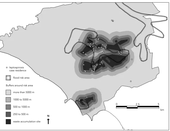
Figure 3
Boundaries of risk areas. Flood risk area and influence areas (buffers) around waste accumulation sites.
leptospirosis case residence
flood risk area
Buffers around risk area
more than 5000 m
1000 to 5000 m
500 to 1000 m
250 to 500 m
waste accumulation site N
0 2.5
accumulation sites. For distances greater than 1,000 m from these sites, incidence rates de-crease towards values comparable to endemic periods. The highest rate is observed not at the core of waste accumulation sites, but surround-ing these sites (at a distance of 250 to 500 m). This difference is statistically significant ac-cording to a chi-square test considering a Pois-son distribution of cases. Surprisingly, based on the map (Figure 3), most cases occurred in areas that do not present waste accumulation problems. On the contrary, critical areas, where suspected disease foci are located, contain a negligible number of cases.
A combination solid waste accumulation and flood conditions is the most appropriate theoretical explanation for leptospirosis. Inci-dence rates for each class of combined situa-tions for these risk areas are shown in Figure 4. Observed incidence rates decrease with the distance from waste accumulation sites. Higher incidence rates are observed for census tracts
from waste accumulation sites. However, the combined effect of waste accumulation and flooding is more intense in the vicinity of the suspected foci. The lowest incidence rate is ob-served for census tracts outside flood risk areas and far from waste accumulation sites. When compared to these tracts, higher risk areas show a tenfold incidence rate.
The outbreak mainly affected the popula-tion residing close to waste accumulapopula-tion sites. However, residents of census tracts outside flood risk areas were protected from the disease. The spatial gap observed between disease clusters and environmental risk factors can be explained by immunological, geographic, and exposure characteristics. First, leptospirosis cases under flood conditions can occur far from the sus-pected foci due to individual immunological protection in inhabitants of these foci. People living at distances greater than 1000 m from fo-ci are probably protected against rodents and the infectious agent due to the limited disper-sion capacity during the flood. Conversely, peo-ple living close to risk areas are expected to have had contact with the infectious agent pri-or to the flood, thus acquiring immunity due to the proximity of suspected foci (Pavlowsky, 1988). In this sense, slums can be considered endemic areas for leptospirosis, yet displaying low incidence rates during the outbreak. A sur-vey performed in one of the lowland Rio de Ja-neiro slums demonstrated a human serological prevalence as high as 25 %, with an infection rate of 1% per year (Pereira & Andrade, 1990). In such cases, infection is found to be related to occupational and behavioral factors, pre-senting a typically endemic evolutionary pat-tern (Velazquez et al., 1984).
Second, the range between risk factors and location of case residence may be an artifact produced by errors involved in the location of geographic features in GIS. This is probably a refutable reason, due to the technical features of GIS. The average CT area is 0.28 km2, with an
average radius of 210 m. The location error of GPS equipment (Global Position System, a satellite-based coordinate acquirer) is between 20 and 40 m. The average length of street seg-ments is 150 m. As the reported case residences were located by interpolation in street seg-ments, a maximum error of 75 m is expected for coordinates of the recording position. These distances are considerably greater than the lin-ear resolution of the CT base map, which has an expected error of 2.5 m. Values are related to the scale on which the cartographic base was constructed. Each working scale induces a
res-Table 1
Population, number of cases, and incidence rate in and outside the flood risk area.
Population Leptospirosis Incidence cases rate*
Inside flood risk area 83241 35 42.05 Outside flood risk area 192407 38 19.75
Total 275648 73 26.48
* statistically different according to chi-square test.
Table 2
Population, number of cases, and incidence rate according to the distance from waste accumulation sites.
Distance from foci (m) Population Leptospirosis Incidence cases rate
Less than 250 49003 11 22.45
250 - 500 51092 40 78.29a
500 - 1000 35364 8 22.62
1000 - 5000 36337 8 22.02
More than 5000 103852 6 5.78b
Total 275648 73 26.48
Figure 4
Leptospirosis incidence rate according to distance from suspected foci and flood areas in the Rio de Janeiro western region, in cases per 100,000 inhabitants.
0 10 20 30 40 50 60 70 80
inside flood area
outside flood area
more than 5000m distance (m) 500 to 5000m
less than 500m
incidence rate
obtained from the map. In this study, the dis-tance at which poor sanitation services influ-ence location of leptospirosis cases is consid-erably greater than the pertinent geo-referenc-ing errors.
Finally, contact between the infectious agent and susceptible individuals can occur distant from the supposed foci or the case residence because of rodent and human circulation, es-pecially during floods. As mentioned before, the 1996 summer flood persisted for several days, and people may have been exposed to contaminated floodwater and mud on their way to work and shopping, although living in a well-served and non-inundated area. Unfortu-nately, GIS often works with a static represen-tation of geographic entities, although space is composed of a system of objects and actions (Santos, 1996).
A disease production model for flood situa-tions is summarized in Figure 5. During dry pe-riods, high leptospira concentrations in the soil are limited to a few meters around waste accumulation sources. During floods, the in-fectious agent spreads and reaches distant ar-eas under the impact of water. This same flood dilutes both the agent and also its infectivity at great distances from the source. This disper-sion promotes the agent’s contact with popula-tion groups, i.e., individuals with no previous contact with the bacteria. Individuals living close to foci are believed to have more frequent contact with the agent, given the higher preva-lence of infection there. Thus, a shift in seropos-itivity can be predicted in flood situations. Some infected individuals (approximately 30%) may develop the disease, depending not only on in-dividual immunological conditions, but also the exposure route and dose (Benenson, 1997).
Final comments
Leptospirosis cases result from a combination of negative social and environmental condi-tions. This same environment is also the stage for collective health measures such as sanita-tion practices. In the case of Rio de Janeiro’s western region, high incidence rates were iden-tified in areas that had precarious sanitation conditions and were vulnerable to floods. This relationship is not direct, nor does one observe the exact location where environmental risks are concentrated. Densely populated urban ar-eas displayed an excess of leptospirosis cases around waste accumulation sites. Rural and mountainous areas and those with sewage and waste collection services are protected against
Figure 5
Conceptual model of leptospirosis spread during flood situations. Variation of risk indicators as a function of distance to solid waste source.
distance distance
estimated waste accumulation
expected rodent density
expected leptospire concentration before the flood
expected leptospire concentration during the flood
expected seroprevalence before the flood
expected seroprevalence during the flood
Acknowledgments
Epidemiological data were kindly provided by the Rio de Janeiro State Health Secretariat. Other field and cartographic information was gathered by Simone M. dos Santos and Maria de Fátima Pina. The authors wish to thank the useful collaboration of Celia Leitão Ramos on the paper review. This research was sup-ported by the National Research Council (CNPq). the proliferation of rodents and pathogenic
mi-croorganisms. Urbanization thus plays a dou-ble role of promoting education and sanita-tion, but increasing interactions of infectious agents and the population by overcrowding and pollution (Williams, 1990).
Exposure to infectious agents is an environ-mental and therefore collective process. The environmental conditions fostering diseases are impossible to retrieve through the aggrega-tion of individual data, but may more likely be obtained from bases other than strictly epi-demiological data (Vine et al., 1997; Diez-Roux, 1998). Individual response to environmental exposure is complementary and may diverge from collective data. For instance, most of the investigated cases deny contact with solid waste, despite living near areas with deficient municipal waste collection. Such areas are la-tent disease foci, and even when a residence
References
ALMEIDA, L. P.; MARTINS, L. F.; BROD, C. S. & GER-MANO, P. M., 1994. Seroepidemiologic survey of leptospirosis among environmental sanitation workers in an urban locality in the southern re-gion of Brazil. Revista de Saúde Pública, 28:76-81. ARGENTO, M. S.; CARVALHO Jr., W.; CRUZ, C. B. M. & MAYR, L. M., 1995. Impactos ambientais de gran-des empreendimentos: O caso de Sepetiba. In: IV Congresso Brasileiro de Defesa do Meio Ambien-te, Anais, pp. 323-333, Rio de Janeiro: Editora da Universidade Federal do Rio de Janeiro.
BARCELLOS, C. & SABROZA, P. C., 2000. Socio-envi-ronmental determinants of the leptospirosis out-break of 1996 in western Rio de Janeiro: A geo-graphic approach. International Journal of Envi-ronmental Health Research.
BENENSON, A. S., 1997. Manual para el Control de las Enfermedades Transmisibles. Washington, D.C.: Organización Panamericana de la Salud. BRIGGS, D. J., 1992. Mapping environmental
expo-sure. In: Geographic and Environmental Epidemi-ology: Methods for Small-Area Studies(P. Elliot, ed.), pp. 158-176, Tokyo: Oxford University Press. CRONER, C. M.; SPERLING, J. & BROOME, F. R., 1996.
Geographic Information Systems (GIS): New per-spectives in understanding human health and environmental relationships. Statistics in Medi-cine, 15:1961-1977.
DIEZ-ROUX, A. V., 1998. Bringing context back into epidemiology: Variables and multilevel analysis.
American Journal of Public Health, 88:216-222. GESLER, W. M.; BIRD, S. T. & OLJESKI, A. S., 1997.
Dis-ease ecology and a reformist alternative: The case of infant mortality. Social Science and Medicine, 44:657-671.
HELLER, L., 1997. Saneamento e Saúde. Brasília: Or-ganização Panamericana da Saúde.
IBGE, 2000. SIDRA – Sistema IBGE de Recuperação Automática. March 2000 <http://www.sidra.ibge. gov.br>.
IPLANRIO (Empresa Municipal de Informática e Pla-nejamento), 1995. Anuário Estatístico da Cidade do Rio de Janeiro.Rio de Janeiro: IPLANRIO. KATZ, A. R.; MANEA, S. J. & SASAKI, D. M., 1991.
Lep-tospirosis on Kauai: Investigation of a common source of waterborne outbreak. American Journal of Public Health, 81:1310-1312.
KO, A. I.; GALVÃO-REIS, M.; RIBEIRO-DOURADO, C. M.; JOHNSON, W. D. & RILEY, L. W., 1999. Urban epidemic of severe leptospirosis in Brazil. Lancet, 354:820-825.
KOLSKY, P. J. & BLUMENTHAL, U. J., 1995. Environ-mental health indicators and sanitation-related disease in developing countries: Limitations to the use of routine data. World Health Statistics Quarterly, 48:132-139.
LACAZ, C. S.; BARUZZI, R. G. & SIQUEIRA Jr., W., 1972. Introdução à Geografia Médica do Brasil. São Paulo: Editora Edgard Blucher.
NURMINEN, M., 1995. Linkage failures in ecological studies. World Health Statistics Quarterly, 48:78-84.
PAVLOWSKY, E., 1988. Natural nidality of transmissi-ble diseases in relation to landscape epidemiolo-gy of zooanthroponoeses. In: The Challenge of Epidemiology. PAHO Scientific Publication No. 505, pp. 401-405, Washington, D.C.: Pan Ameri-can Health Organization.
PEREIRA, M. M. & ANDRADE, J., 1988. Epidemiologi-cal aspects of leptospirosis in a slum area in the city of Rio de Janeiro, Brazil. Search for leptospiro-sis and specific antibodies in rodents. Transac-tions of the Royal Society of Tropical Medicine and Hygiene, 82:768-770.
PEREIRA, M. M. & ANDRADE, J., 1990. Human lep-tospirosis in a slum area in the city of Rio de Janeiro, Brazil – A serological and epidemiologi-cal study. Memórias do Instituto Oswaldo Cruz, 85:47-52.
PHILIPPI Jr., A., 1988. Saneamento do Meio. São Paulo: Editora Fundacentro.
SANTOS, M., 1996. Técnica, Espaço, Tempo. São Paulo: Editora Hucitec.
SEXTON, K.; WAGENER, D. K. & LYBARGER, J. A., 1992. Estimating human exposures to environ-mental pollutants: Availability and utility of exist-ing databases. Archives of Environmental Health, 47:398-407.
SMS (Secretaria Municipal de Saúde), 1997. Série His-tórica da Leptospirose no Rio de Janeiro. Rio de Ja-neiro: Superintendência de Saúde Coletiva, Se-cretaria Municipal de Saúde.
VELAZQUEZ, J. Z.; CANTARELL, K. P.; CASTILLO, M. F. & CENTENO, A. G. D., 1984. La leptospirosis en Yucatán. Estudio serológico en humanos y ani-males. Salud Pública de México, 26:254-259. VINE, M. F.; DEGNAN, D. & HANCHETTE, C., 1997.
Geographic information systems: Their use in en-vironmental epidemiologic research. Environ-mental Health Perspectives, 105:598-605. WILLIAMS, B. T., 1990. Assessing the health impact of